|
Other Archaeological Sites / The Neolithic of the Levant (500 Page Book Online) Arsinoe Arsinoë Arsinoę Arsinoé --- Serapiu Serapeum --- Pihahiroth Read Page 225 in Dictionary of Greek and Roman Geography by William Smith (1854) Arsinoë in the Perseus Digital Library (Tufts University)
ProofRead and Updated April 8th 2020
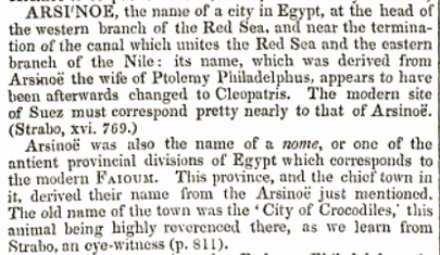
Arsinoé, the name of a city in Egypt at the head of the western branch of the Red Sea and near the termination of the canal which unites the Red Sea and the eastern branch of the Nile: its name, which was derived from Arsinoé the wife of Ptolemy Philadelphus, appears to have been afterwards changed to Cleopatris. The modern site of Suez must correspond pretty nearly to that of Arsinoé (Strabo Geography, Book XVI, Chapter 4, Note 208)
See: Page 406 in The Penny Cyclopedia (1833)
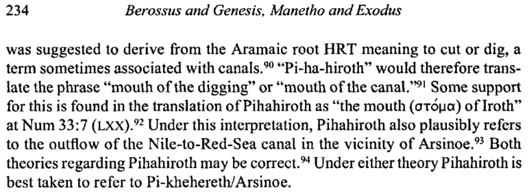
Berossus and Genesis -- Manetho and Exodus: Hellenistic Histories
Page 10 in An Atlas of Ancient Egypt --- Egypt Exploration Fund (1894)
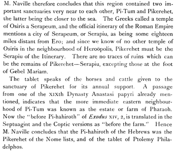
Naville therefore concludes that this region contained two important
sanctuaries very near to each other -- Pi-Tum and Pikerehet --
the latter being the closer to the sea. The Greeks called a temple
of Osiris a Serapeum and the official itinerary of the Roman Empire
mentions a city of Serapeum or Serapiu as being some eighteen
miles distant from Ero; and since we know of no other temple of
Osiris in the neighbourhood of Heroopolis, Pikerehet must be the
Serapiu of the Itinerary. There are no traces of ruins which can
be the remains of Pikerchet -- Serapiu excepting those at the foot
of Gebel Mariam. The tablet speaks of the horses and cattle given to the sanctuary of Pikerehet for its annual support. A passage from one of the xixth Dynasty Anastasi papyri already mentioned indicates that the more immediate eastern neighbourhood of Pi-Tum was known as the estate or farm of Pharaoh. Now the "before Pi-hahiroth” of Exodus xiv 2 is translated in the Septuagint and the Coptic versions as "before the farm”. Hence Naville concludes that the Pi-hahiroth of the Hebrews was the Pikerehet of the Nome lists and of the tablet of Ptolemy Philadelphos.
The Geography of Strabo --- Loeb Classical Library Edition 1932
(804) There is another canal which empties into the Red Sea and the Arabian Gulf near the city Arsinoę, a city which some call Cleopatris. It flows also through the Bitter Lakes, as they are called, which were indeed bitter in earlier times but when the above-mentioned canal was cut they underwent a change because of the mixing with the river and now are well supplied with fish and full also of aquatic birds. The canal was first cut by Sesostris before the Trojan War -- though some say by the son of Psammitichus, who only began the work and then died -- and later by Dareius the First, who succeeded to the next work done upon it. But he too, having been persuaded by a false notion, abandoned the work when it was already near completion; for he was persuaded that the Red Sea was higher than Aegypt and that if the intervening isthmus were cut all the way through Aegypt would be inundated by the sea. The Ptolemaďc hands however cut through it and made the strait a closed passage so when they wished they could sail out without hindrance into the outer sea and sail in again. But I have already discussed the levels of the bodies of water in my first commentaries. The History of the Ancient Near East Electronic Compendium |