THE
NEOLITHIC
OF
THE
LEVANT
A.M.T.
Moore
University
College
Volume
1
Thesis
submitted
for the
Degree
of
Doctor
of
Philosophy,
Oxford
University
1978
-
1
-
CONTENTS
Volume
1
page
CONTENTS
FIGURES
AND
TABLES
ABSTRACT
ACKNOWLEDGEMENTS
INTRODUCTION
Chapter
1
THE
ENVIRONMENT
OF
THE
LEVANT
IN
THE
LATE
PLEISTOCENE
AND
EARLY
HOLOCENE
Late
Pleistocene
Summary
Early
Holocene
Summary
Chapter
2
THE
MESOLITHIC
OF
THE
LEVANT
Mesolithic
1
Settlement
patterns
Economy
and
society
Mesolithic
2
Settlement
patterns
Economy
and
society
Chapter
3
NEOLITHIC
1
Distribution
of
sites
Economy
Discussion
Chapter
k
NEOLITHIC
2
Middle
Euphrates
West
Syria
Palestine
Relationships
between
Palestinian,
West
Syrian
and
Middle
Euphrates
sites
in
Neolithic
2
Mt.
Carmel
Jordan
valley
Judean
hills
Negev
and
Sinai
TransJordan
plateau
IV
vii
viii
1
11
21
25
31
37
hh
^
61
63
Qk
133
136
1U9
160
161
190
211
226
230
231
237
-
11
-
Contents
(continued)
Chapter
k
(continued)
page
Principal
cultural
characteristics
of
Neolithic
2
settlements
Distribution of
sites
Economy
Middle
Euphrates
sites
West
Syrian
sites
Palestinian
sites
Discussion
256
260
265
272
273
286
Volume
2
Chapter
5
NEOLITHIC
3
Middle
Euphrates
North Syria
South
Syria
Lebanese
coast
Beka'a
Damascus
basin
Palestine
South
Palestine
North
Palestine
Principal
cultural
characteristics
of
Neolithic
3
settlements
Timespan
of
Neolithic
3
Distribution
of
sites
Economy
Discussion
Chapter
6
NEOLITHIC
South
Syria
Lebanese
coast
Beka'a
Damascus
basin
Palestine
South
Palestine
North
Palestine
West
Palestine
Distribution
of
sites
296
299
329
3^2
355
358
359
367
379
382
38U
387
397
>*08
UU8
U65

-
Ill
-
Contents
(continued)
page
Chapter
6
(continued)
Economy
Community
organization
and
trade
^-75
Chapter
7
CONCLUSION
^79
APPENDIX
Carbon
1U
dating
^96
NOTES
500
BIBLIOGRAPHY
502

-
iv
-
FIGURES
AND
TABLES
All
artifacts
drawn
full size
unless
otherwise
indicated
page
Volume
1
Fig.
1
The
Levant
1
Fig.
2
A
reconstruction
of
vegetation
zones
c.
9000
B.C.
23
Fig.
3
A
reconstruction
of
vegetation
zones
c.
6000
B.C.
31
Fig.
k
A
reconstruction
of
vegetation
zones
c.
UOOO
B.C.
32
Fig.
5
Distribution
of
Mesolithic
1
sites
^2
Fig.
6
Distribution
of
Mesolithic
2
sites
61
Fig.
7
Jericho
Proto-Neolithic
-
flint
borers and burins
93
Fig.
8
Jericho
Proto-Neolithic
-
flint
scrapers
9^-
Fig.
9
Jericho
Proto-Neolithic
-
flint
sickle
blades
and
adze
95
Fig.
10
Jericho
PPNA
-
flint
scrapers,
borers
and
burins
96
Fig.
11
Jericho
PPNA
-
flint
adze
and
sickle
blades
96
Fig.
12
Neolithic
1
village
at
Nahal
Oren
(after
Stekelis
and
Yizraely)
100
Fig.
13
Nahal
Oren
Neolithic
1
flint
tools
102
Fig.
1U
Nahal
Oren
Neolithic
1
flint
tools
103
Fig.
15
a
-
El
Khiam
points (after
Perrot)
107
b
-
Harif
points
(after
Marks)
Fig.
16
Mureybat
IB-Ill
-
flint
arrovheads
and
adze
(after
Cauvin)
121
Fig.
17
Distribution
of
Neolithic
1
sites
133
Fig.
18
Extent
of
Neolithic
2
settlement
160
Fig.
19
Neolithic
2
Middle
Euphrates
sites
161
Fig.
20
Environs
of
Tell
Abu
Hureyra
163
Fig.
21
Tell
Abu
Hureyra
-
contour
plan
16U
Fig.
22
Tell
Abu
Hureyra
-
butterfly
beads
166
Fig.
23 Tell
Abu
Hureyra
-
double-ended
flint
cores
167
Fig.
2U
Tell
Abu
Hureyra
-
flint
arrowheads
168
-
v
-
Figures
and
Tables
(continued)
page
Fig.
25
Tell
Abu
Hureyra
-
Amuq
arrowheads
168
Fig.
26
Tell
Abu Hureyra
-
flint
scrapers
168
Fig.
27
Tell
Abu
Hureyra
-
flint
burins
169
Fig.
28
Tell
Abu Hureyra
-
flint
borers
169
Fig.
29
Tell
Abu
Hureyra
-
flint
sickle
blades
169
Fig.
30
Tell
Abu
Hureyra
-
bone
tools
171
Fig.
31
Tell
Abu
Hureyra
-
polished
stone
axes
and
chisel
172
Fig.
32
Neolithic
2
West
Syrian
sites
190
Fig.
33
Neolithic
2
Palestinian
sites
211
Fig.
3^
Beidha
-
Level
II
buildings
(after
Kirkbride
and
Perrot)
2h6
Volume
2
Fig.
35
Extent
of
Neolithic
3
settlement
295
Fig.
36
Neolithic
3
North
Syrian
sites
299
Fig.
37
Horns
-
Amuq
points
(after
de
Contenson)
305
Fig. 38
Pattern-burnished
vessels
310
a
-
Tell
Judaidah
(after
Braidwood
and
Braidwood)
b
-
Byblos
(after
Dunand)
Fig.
39
Neolithic
3
South
Syrian
sites
328
Fig.
hO
Byblos
-
Ne"olithique
Ancien
houses
(after
Dunand)
331
Fig.
hi
Byblos
Neolithique
Ancien
333
a
-
sickle
blades
(after
Cauvin)
b
-
Byblos points
Fig.
h2
Byblos
-
Neolithique
Ancien
jars
(after
Dunand)
335
Fig.
h3
Byblos
-
Ne"olithique
Ancien
bowls
(after
Dunand)
336
Fig.
hh
Neolithic
3
Palestinian
sites
359
Fig.
lj-5
Distribution
of
Neolithic
h
sites
U12
Fig.
h6
Byblos
-
N£olithique
Moyen
flint
tools
(after
Cauvin)
Ul6
Fig.
hj
Byblos
-
Ne"olithique
Recent
flint tools
(after
Cauvin)
U17
Fig.
U8
Byblos
-
Ngolithique
Moyen
jars
(after
Dunand)
-
vi
-
Figures
and
Tables
(continued)
page
Fig.
h9
Byblos
-
Ngolithique
Re*cent
bowls
and
jars
(after
Dunand)
Fig.
50
Neolithic
h
South
Syrian
sites
Fig.
51
Neolithic
U
Palestinian
sites
Fig.
52
Jericho
-
Pottery
Neolithic
B
vessels
Fig.
53
Palestine
-
supplementary Neolithic
3
and
k
sites
Fig.
5U
Estimated
14
C
calibration
curve
to
10,000
B.C.
Table
1
Percentages
of
obsidian
in
each
cultural phase
at
Tell
Abu
Hureyra
171
Table
2
1*98
-
vii
-
ABSTRACT
THE
NEOLITHIC
OF
THE
LEVANT
A.M.T.
Moore
University
College
Doctor
of
Philosophy
Hilary
Term
1978
The
archaeological
evidence
for
the
Neolithic
of the
Levant,
considered
to
have
lasted
from
c.
8500
to
3750
B.C.,
is
presented
and
an
attempt made
to
explain
its
origins
and
development.
The
discussion
is
concerned
with
four
principal
themes:
(1)
the
transition
from
a
hunter-gatherer
to
a
farming
economy,
(2)
the
social
evolution
that
accompanied
this
economic
development,
(3)
population
growth
immediately
"before
and during the
Neolithic
and
(U)
the
modifications
in
settlement
patterns
which followed
these other
changes.
The
environmental
changes
which
occurred
at
the
end
of
the
Pleistocene
and
early
in
the
Holocene
are
believed
to
"be
of
fundamental
importance.
The
degree
of
their
influence
on
the
four
main
themes
is
examined.
The
effects
of
man's
own
changing
activities
upon
his
environment
are
also
considered.
The
Neolithic
of
the
Levant
is
divided
into
four
stages,
designated
Neolithic
1
to
U,
on
the
evidence
of changes
in
economy,
population,
settlement
patterns
and
cultural
remains.
Regional
groups
of
sites,
defined
"by
their
cultural
material,
may
"be
discerned
and
their
evolution
followed
from
one
stage
to
the
next.
The
detailed archaeological
evidence
is
examined
principally
for
the
light
it
throws
upon
the
development
of
the
four
main
themes
of
the
thesis and
the
contemporary
changes
in
environment.
It
is
argued
that
the
amelioration
of
the
environment
in
the
late
Pleistocene
created
a
greater supply of
wild
foods
for
man
which
stimulated
population
growth.
This
was
accompanied
by
increased
sedentism
and
the
development
of
agricultural
techniques.
In
Neolithic
2
agriculture
was
intensified
and
the
population
grew
further.
After
6000
B.C.
the
population
of
the
Levant
lived
in
permanent
settlements
supported
"by
agriculture
"but
these
were
concentrated
only
in
the
more
fertile
and
well-watered
areas of
the
Levant.
This
new
way
of
life
permitted
another
increase
in
population
in
Neolithic
^
despite
a
deterioration
in
the
environment.
-
viii
-
ACKNOWLEDGEMENTS
This
thesis
was
written between
1975
and
1977
but
much of
the
information
I
have
used
was
obtained
in
studies
carried
out
as
far
back
as
1969
when
I
first
went
to
the
Near
East to
begin
research.
Throughout
I
have
benefited
from
the
encouragement and
advice
of
my
supervisor,
Dame
Kathleen
Kenyon.
She
introduced
me
to
Near
Eastern
Archaeology
by
inviting
me
to
participate
in
her
excavations
in
Jerusalem
in
1966.
She has
allowed
me to
study
all the
available
Neolithic
material
from
her
excavations
at
Jericho
and
to
use
whatever
information
I
needed
from
the
records
of
the
excavation.
Her
firm
criticism
has
clarified
my
thinking
and
writing
while
her
generous
praise
has
given
welcome
support.
I
owe
her
much.
I
studied under
Professor
J.D.
Evans
at
the
Institute
of
Archaeology
of
London
University
from
1967 to
1969.
It
was he
who
stimulated
my
interest
in
prehistory
and
the
problems
of
the
Neolithic.
His
humane
approach to
the
study
of
prehistory
has
influenced
my
own
work
and
I
am
grateful
to
him
for his
continued
interest
in
the
progress
of
my
research.
The
Queen's
College,
Oxford
awarded
me
a
Randall
Maclver
Studentship
from
1969
to
1971
and
the
British
School
of
Archaeology
in
Jerusalem
made
me
their
Annual
Scholar
from
1969
to
1970.
These
two
studentships
enabled
me
to
spend
a
year
and
a
half
travelling
through
much
of
the
Near
East,
visiting
ancient
sites
and
studying
museum
collections.
During
this
period
I
formed
a
working
knowledge
of
the
available
archaeological material
which
I
have
used
in
preparing
this
thesis.
In
1973
I
was
awarded
a
Gerald
Averay
Wainwright
Research
Fellowship
in
Near
Eastern
Archaeology
at
Oxford.
This
Fellowship
has
supported
me
while
I
prepared
the
text
of
the
thesis;
it
has also
allowed
me
to
continue
work
on
my
other research
projects,
in
particular
my
excavation
of
Tell
Abu
Hureyra.
I
wish
to
thank
the
Curators
and
staff
of the
Pitt
Rivers
Museum
and
Dr.
D.A.
Roe
of
the
Donald
Baden-Powell Quaternary
Research
Centre
for
-
ix
-
affording
me
facilities
and
practical
help
during
the
preparation
of
this
thesis.
In
all
my
sojourns
in
the
Levant
the
Directors
and
staff
of
the
Depart-
ments
of
Antiquities
in
each
country
have
readily
granted
me
permission
to
carry
out
my
research.
The
Curators
of
all
the
major
museums have
also
allowed
me full
access
to the
collections
of
material
in
their
charge.
It
will
be
evident
that
I
could have
accomplished
little
without
this
help.
These
authorities
have
also
frequently
given
me
much
other
practical
assistance
and
generous
hospitality
for
which
I
offer
my
grateful
thanks.
Very
many
other
people
from
high
officials
to
simple
peasants
and
nomads
have
helped
me
in
my
travels
so
putting
me
in
their
de~bt
in
ways
that
cannot
be
repaid.
It
is
a
pleasure
to
recall
and
acknowledge
these
innumerable
kindnesses
here
which
have
been
given
so
freely
in
the
true
tradition
of
Levantine
hospitality.
Many
archaeologists
and
other
scholars
in
several
countries
have
allowed
me
to
study
material
from
their
excavations
or
from
collections
in
their
care.
Much
of
this
information
has
been
incorporated
in
the
thesis.
Others
have
helped
me
by
analysing
samples
submitted
to
them.
All
have
willingly
answered
my
questions
and
discussed
matters
of
common
interest.
I
wish
to
thank
them
all
and
in
particular
the
following:
Prof.
E.
Anati
for
showing
me
his
material
from
Tell
Abu
Zureiq;
Prof,
and
Mrs.
Braidwood
for
showing
me
their
material
from
the
Amuq
tells,
Tell
Fakhariyah,
Tabbat
el
Hammam
and
other
sites
as
well
as
much
helpful
discussion;
M.
and
Mme
J.
Cauvin
for
showing
me
their
excavations
at
Mureybat
and
material
from
the
site,
and
for
several
useful
discussions;
M. H.
de
Contenson
for first
introducing
me
to
the
archaeology
of
Syria,
for
allowing
me
to
participate
in
his
excavations
at
Tell
Aswad
in
1971
9
for
access
to material
he
has
excavated
from
other
sites
and
for
many
other
kindnesses;
Mrs.
L.
Copeland
for
numerous
discussions
on
the
prehistory
of
the
Levant
and
much valuable
help
and
advice given
over
many
years;
Dr.
R.
Dornemann
for
allowing
me
to
study
his
material
from
El Kum;
M. M.
Dunand
for
permitting
me to
study
material from
Byblos
,
showing
me
his
excavations
-
x
-
and
much
kind
hospitality;
Prof.
R.
Dyson
for
allowing
me
to
see
material
in
the
University
Museum
of
the
University
of
Pennsylvania;
Pe"re
H.
Fleisch
S.J.
for
giving
me
free
access
to
the
collections
in
the
Universite*
Saint-
Joseph,
Beirut and
for
much
valuable
information;
Dr.
D.H.
French
for access
to
the
collections
of
the
British
Institute
of
Archaeology
in
Ankara;
Dr.
J.B.
Hennessy
for
showing
me
his
material from
Teleilat
Ghassul
and
for
much
other
help
in
Jerusalem;
G.
Hillman
for
analysing
the
plant
remains
from
my
excava-
tion
at
Tell
Abu
Hureyra;
P£re
F.
Hours
S.J.
for
information
about
his
excavations
at
Jiita,
help
in
the
Universite"
Saint-Joseph, Beirut
and
many
valuable
discussions;
J.
Kaplan
for
allowing
me
to
study
material from
several
of
his
excavations;
L.H.
Keeley
for
examining
several
tools
from
Tell
Abu
Hureyra
for
traces
of
microwear;
Prof.
C.C.
Lamberg-Karlovsky
for
access
to
the
collections
of
the
Peabody
Museum,
Harvard
University;
A.J.
Legge
for
information
about
his
work
at
Nahal
Oren
and
for
examining
the
faunal
remains
from
Tell
Abu
Hureyra;
Prof.
A.E.
Marks
for
allowing
me to
study
material
from
his
excavations
at
Southern
Methodist
University,
Dallas;
Prof.
M.J.
Mellink
for
access
to
the
material
from
Tarsus
kept
at
Bryn
Mawr
College;
Mrs.
J.
Crowfoot
Payne
for
showing
me
the
chipped
stone tools
from
Jericho
and
for
many
helpful
discussions;
M.
J.
Perrot
and
his
assistants
for
showing
me
material
from
his
excavations;
Dr.
B.
Rothenberg
for
allowing
me
to
see
material
from
sites
he
has
discovered
in
Sinai;
Dr.
B.
Schroeder
for
showing
me
material
from
his
excavations
at
Nacharini
and
for
information
about
his
research;
G.
de
G.
Sieveking
and
C.
Bonsall
for
access
to
material
from
Nahal
Oren
and
other
sites
in
the
British
Museum;
the
late
Father
J.
Sira
9
S.J.
for
showing
me
material from
the
first
excavations
at
Teleilat
Ghassul
and
surface collections
from
other
sites
kept
in
the
Pontifical
Biblical
Institute,
Jerusalem;
the
late
Pere
R.
de
Vaux
O.P.
for
allowing
me
to
study
material
from
his
excavations
at
Tell
el
Far'ah
at
the
Ecole
Bibliqjue
Saint-
Etienne,
Jerusalem
and
for
valuable
discussions;
S.E.
Warren
of
Bradford
University
for
all
his
help
in
our
joint
project
of obsidian
analyses,
and
Professor
T.
Cuyler
Young
and
his
assistants
for
showing
me
material
in
the
Royal
Untarid
.Museum,
Toronto.
INTRODUCTION
Man
has
been
a
mobile
hunter-gatherer
for
most
of
his
existence.
This
pattern
was
first
modified
during
the
Neolithic
when
sedentary
societies
were
formed
whose
members
lived
in
permanent
villages
and
depended
upon
agriculture
for
their
livelihood.
These
momentous developments
were
the
most
significant
changes
in
man's
way
of
life
since
his
evolution
as
a
species.
They
were
also
an
essential
first
step
in
the
subsequent
evolution
of
civilization.
The
origins
and
development
of
this
new
social
and
economic
system
in
the
Levant
will be
the
subject
of
my
thesis.
The
Levant
was
one
of
the
regions
in
the
Near
East
where
these
changes
in
society
and
economy
began.
This
happened
well before
the
adoption
of
the
new
way
of
life
by
mobile
societies
in
Europe
and
Africa.
Thus
we
should
study
the
Neolithic
in
this
region
if
we
are
to
understand
how
the
new
pattern
of
existence
came
about
and
what
its
immediate
consequences
were.
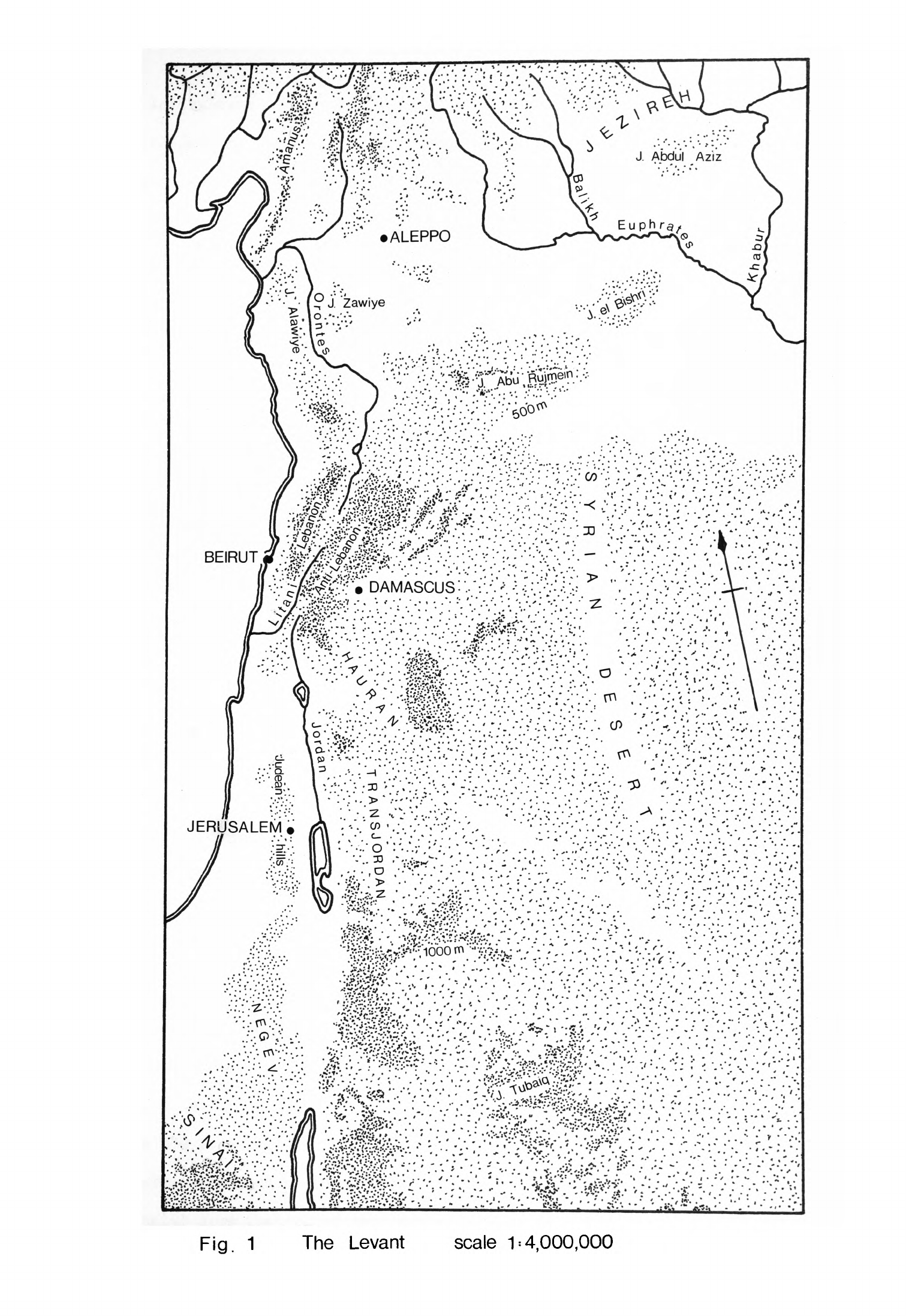
The
Levant
is
a
distinct
geographical
region
defined
by
natural
frontiers
(Fig.
1).
To
the
north
the
Taurus
Mountains
lie
between
it
and
the
Anatolian
plateau
while
to
the
east
and
south-east
the
Syrian
desert
separates
it
from
Mesopotamia
and
Arabia.
Sinai
and
the Gulf
of Suez
form
the
boundary
between
the
Levant
and
Egypt.
These
geographical
limits
also
served
as
cultural
boundaries throughout
the
period
that
I
shall
consider.
They
reinforced
the
regional
nature
of
Levantine
culture
and
its
development.
Thus
the
Levant
formed
both
a
geographical
and
cultural
unit
throughout
the
Neolithic
and,
indeed,
for
some
time
before
which
makes
it
a
particularly
convenient
region
in
which
to
study the
emergence
of
the
new
way
of
life.
It
is
also
the
region
in
the
Near
East
which
has
been
most
intensively
explored
by
archaeologists
interested
in
Mesolithic
and
Neolithic
communities
so
that
we
may
consider
the
origins
and
development
of
the
first
agricultural
societies
in
greater
detail
here
than
anywhere
else.
'.ffr;\.o>;p-«;•!.••.
<;^*
>£?•
<^
„>£.£;.
,'5-»
--.*•.;*-••*
'
.
.
J
*
**.
y»
O*
.*
-.*
.
:-t«^
r
:---:
:
^^.vl-.'^^;^n--
•«••.•.•:>:..•.-.»*.•
>
.
.-
•>
...
-..x...
c^s
r
'.•••
r.y.
•
Fig.
1
The
Levant
scale
1
=
4,000,000
-
2
-
Agriculture
formed
the
"basis
of
the
new
way
of
life
so
the
evolution
of
this
economy
will
be
the
first
main
theme
of
my
thesis.
Agriculture
involves
the
controlled
exploitation
of
plants
and
animals,
the
planting
and
harvesting
of
crops
and
the
reproduction
and
regular
culling
of flocks
and
herds.
I
shall
consider
what
species
of plants
and
animals
were
selected
for
agriculture
by
man
in
the
Levant.
I
shall
also
attempt
to
describe
the
systems
of
farming
employed
and
how
these
species
were
exploited
within
them.
The
change
from
a
hunter-gatherer
to
a
farming
economy
brought
about
considerable
alterations
in
the
way
human
groups
were
organized.
At
the
beginning
they
were
widely
dispersed
across
the
landscape
rarely
remaining
in
one
place
for
more
than
a
few
weeks
at
a
time.
Towards
the end of
the
Neolithic
by
contrast
most people
were
concentrated
in
villages
where
they
spent
all
their
lives.
In
the
course
of this
fundamental
change
in
social
organization
relations
between
members
of
each
group
were
also
greatly
modified.
These
changes
in
social
structure
are
to
us
perhaps
the
most
important
of
all
the
consequences
of
the
Neolithic
since
they
concern
the
way
in
which
members
of our own
species
behave
towards
each
other.
Thus
the
changes
that
took place
in
social
structure
will
be
the
second
principal
theme
of
my
thesis.
We
believe
that
the
population
grew
during
and
after
the
period
of
transition
from
a
hunter-gatherer
to
an
agricultural
way
of
life
in
the
Levant.
This
increase
would
have
been
intimately
connected
with
the
change
in
economy
and
would
have
had
an
important influence
on
the
modifications
of
the social
structure.
A
consideration
of
the
question
of
population
growth
will
be
third
theme
of
my
thesis.
Such
fundamental
changes
in
economy,
social
structure
and
human
numbers
would
be
reflected
in
the
pattern
of
settlement.
The
distribution
of
sites
across
the
landscape
and
their
nature
would
depend upon
all
these
factors.
The
internal
arrangements
of
each
site
might
also
be
expected
to
reflect
the
social
organization
of
its
inhabitants
and
the
size of the
group
which
-
3
-
lived
on
it.
Changes
in
settlement
patterns
will
be
one
of
the
most
important
items
of
archaeological
evidence
that
I
shall
consider
and
in
themselves
will
form
the
fourth
major
theme of my
thesis.
The
transition
from
mobile
hunting
and
gathering
which
had
characterised
man's
existence
throughout
the
Palaeolithic
to
a
Neolithic
agricultural
society
living
in
permanent
villages
took
place
about
the
time
of the
change
from
Pleistocene
to
Holocene.
During
this
period
the
temperature
began
to
rise
world-wide,
the
glaciers
retreated
and
the
sea
level
rose.
This
coin-
cidence
is
important
for
it
may
indicate
that
the
two
phenomena
were
related,
that
the
environmental
changes
created
conditions
which
were
favourable
for
the
development
of
the
Neolithic
way
of
life.
It
will
therefore
be
necessary
to
examine
in
detail the
climate
and
environment
of
the
Levant
in
the
late
Pleistocene
and
to
see
how
these
were
modified
during
the
early
Holocene.
This
will
be
the
subject
of
Chapter
1.
In
subsequent
chapters
I
will
examine the
effects
of
the
environmental
changes
on
the
factors
which
form
the
main
themes
of the thesis.
Man
himself
was not
simply
affected
by
alterations
in
his
environment
but
contributed
to
these
changes
by
exerting
his
own
influence
on
his
surroundings.
During
the
Neolithic,
perhaps
for
the
first
time,
he
came
to
play
a
significant
role
in
determining
the
nature
of
his
environment.
I
shall
discuss
the
evidence
we
have
for
the
effects
of
man
on
his
surroundings
in
appropriate
sections
of
the
thesis.
The
origins
of
the
Neolithic
way
of
life
can
only
be
understood
if
we
know
how
the
people
of
the
Levant
lived
in
earlier
periods.
To
this
end
I
shall
consider
the
Mesolithic
of
the
Levant,
the
stage
preceding
the
Neolithic,
in
Chapter
2
of
the
thesis.
I
shall
examine
in
outline
the
settlement
pattern,
economy,
population
and
social
structure
of
Mesolithic
communities
in
the
Levant
since
these
concern
the
major
themes
of
the
thesis.
The
changes
in
economy,
social structure,
population
and
settlement
that
occurred
during
the
Neolithic
can
only
be
determined
by
a
thorough
enquiry
into
all
the
archaeological
evidence.
It
will
be
necessary
to
consider
most
of
the
known
sites
themselves
and
their
distribution
as
well
as
the
remains
that
have
"been
found
on
them
in
excavation,
survey
or
by
chance.
The
organic
remains
found
on
some
sites are
the
most
important
source
of
evidence
for
the
economy
"but
I
shall
also
consider other
material
that
has
a
bearing
upon
this
main
theme.
The
relative
dates
when
each change
occurred
provide
the
framework
within which
all the
other kinds
of
evidence
must be
ordered.
These
dates
depend
upon
the
chronology
of
the
evolution
of
the
Neolithic
derived
from
absolute
dating and
the
comparative
stratigraphy
of
sites
and
typology
of
artifacts.
I
shall
consider
these
topics
in
detail
at
appropriate
places
in
each
chapter.
The
enquiry
into
the
archaeological
evidence
will
form
the
bulk
of
the
thesis
from
Chapters
3
to
6.
It
will
be seen that
I
conclude
from
this
that
the
evolution
of
the
Neolithic
of the
Levant
falls
into
four
stages.
In
each
chapter
I
shall
first
present
the
archaeological
evidence
for
the
successive
stages.
I
shall
then
consider
changes
in
settlement
patterns,
economy,
social
structure
and
population
in
relation
to
this
evidence.
My
conclusions
on
how
the
Neolithic
began
and
subsequently
developed
will
be
presented
in
Chapter
7.
Much
of
the thesis
will
be
necessarily
devoted
to
establishing
through
a
detailed
description
of
the
archaeological
material
what
happened
in
the
Neolithic.
I
wish
to
take
the
enquiry
further
than
this
by
attempting
to
explain
why
the
changes
that
I
shall
present,
particularly
in
economy,
social
structure and
population,
took
place.
The
scope
of
the
discussion
will
be
broad
since
it
concerns
one
of
the
most
important
changes
that
has
taken
place
in
man's
way
of
life
as
it
occurred
in a
large
region
and
over
a
considerable
span
of time.
It
will
afford
an
opportunity
to
consider
one
of
the
problems
of
modern
archaeological
theory:
is
there
one
all-embracing
model
or
explanation
by
which
the
changes
I
shall
describe
may
be
understood?
Is
there
any
single
event
or
cause
to
which
all
that
followed
may be
attributed?
Were
there
several
factors
which
determined
the
course
of
events?

-
5
-
On
the
other
hand,
did the
Neolithic
of
the
Levant
come
a"bout
as
the
result
of some
haphazard
conjunction
of
circumstances?
Or
are
there
other
explana-
tions
for
this
fundamental
change
which
lie
between
the
two
extremes
of
these
theoretical
approaches?
-
6
-
Chapter
1
THE
ENVIRONMENT
OF
THE
LEVANT
IN
THE
LATE
PLEISTOCENE
AND
EARLY
HOLOCENE
The
environment
of
the
Levant
at
the
close
of
the
Pleistocene
and
early
in
the
Holocene
was
until
recently
poorly
understood.
It
had
long
"been
thought
that
changes
in
the
environment
at
the
end
of
the
Pleistocene
contributed
to
the
evolution
of
the
Neolithic
way
of life
but
the
influence
of
these
changes
could
not
be
properly
assessed.
Recent
studies
in
geo-
morphology, palynology
and
palaeozoology
have
produced new
evidence
on
which
to
base
an
outline
reconstruction
of
the
environment
in
the
late
Quaternary.
I
will
begin
this
chapter
by
discussing
certain
general
factors
which
affected
the
environment
of
the
whole
Levant.
I
will
then
consider
the
evidence
for
the
climate,
landscape
and
vegetation
of
each
region
of
the
Levant
and
how
they
were
modified,
first
in
the
late
Pleistocene
and
after
in
the
early
Holocene.
In
northern
latitudes
the
late
Pleistocene
is
marked
by
the
Wtlrm/
Wisconsin
glaciation.
The
Near
East
was
not
directly
affected
by
the
advance
of
the
European
ice
sheets
but
its
climate
was
significantly
altered
none-
theless.
An
indication
of
these
climatic
changes
has
been
obtained from
studies
of
the
fauna
and
sediments
in
several
deep-sea
cores.
Analyses
of
cores
drilled
in
the
Red
Sea
have
determined
that
the
climate
was
cooler
and
more
humid
there
during
the
period
of
the
last
glaciation
(Herman,
1968,
3^5)
.
Two
other
deep-sea
cores
have
been
drilled
in
late
Quaternary
deposits
in
the
eastern
Mediterranean,
one
between
Cyprus
and
Crete
(no.
189)
and
the
other
west
of
Crete
(V
10.67).
Oxygen
isotope
analysis
of
these
cores
has
shown
that
the
temperature
of
the
Mediterranean
fell
considerably
during
the
period
of the
last
glaciation
(Emiliani,
1955
9
90;
Vergnaud-Grazzini,
Herman-Rosenberg,
1969,
288}
and
studies
of
the
fauna
of
core
V
10.67
have
confirmed
this
conclusion
(Vergnaud-Grazzini,
Herman-Rosenberg,
1969,
2b3).
There
is
some
doubt
about
how
much
the
temperature
actually
decreased
at
this
-
7
-
time
but recent
work
suggests
that
the
estimate
of
Vergnaud-Grazzini
and
Herman-Rosehberg
of
a
fall
of
between
5°
and
10 C
is
the
more
reasonable
(Farrand,
1971, 53*0.
This drop
in
temperature
caused
increased
glacial
activity
in
the
mountainous
regions
of
the
Eastern
Mediterranean.
The
present
relict
glaciers
in
the
Taurus
expanded
considerably
and
it
is
estimated
that
the
snowline
lay
about 1000m
lower
than
today
(Messerli,
1967,
139),
that
is
at
about
2650m.
It
is
also
believed
that
there
were
glaciers
in
the
Mountains
of
Lebanon
and
on
Mount
Hermon
(Kaiser,
1961,
131ff;
Klaer,
1962,
97;
Messerli,
1966,
U6ff)
but
there
is
a
divergence
of
opinion
over
how
much
the
snowline
was
depressed
in
the
Levant.
Klaer
claims
that
the
permanent
snowline
today
would
lie
between
3200
and
3^00m
(1962,
97)
but
Messerli
estimates that
it
would
be
as
high
as
3700m
(1966,
61),
that
is
above
the
summits
of
the
highest
mountains
in
the
Lebanon.
Both
derive
their
different
estimates
from
studies
of
present
snowfall.
Klaer
and
Messerli
have
also
examined
the
evidence
for
glaciation
in
the
mountains
and almost
agree
on
the level
of
the
permanent
snowline
during
the
Wurm.
Klaer
thinks
that
it
lay
between
2750
and
2850m
and
so
fell
about
500m
(1962,
117);
Messerli
believes
that
the
snowline
was
at
about
2700m
(1966, 61),
a
much
greater
fall
of
about
1000m.
Messerli's estimate
of
a
depression
of
about
1000m
would
agree
better
with
the
evidence
from
the Taurus and
so
may
be
the
more
likely.
If
a
fall
in
the air
temperature
was
the
sole
cause
of
this
lowering
of
the
snowline
then
it
would
need
to
have
dropped
about
6
or
7 C
(Messerli,
1967
9
207;
Farrand,
1971,
550),
an
estimate
which
agrees
broadly
with
the
evidence
of
the
deep-sea
cores.
Studies of
the
sediments
of
some
cave
sites
in
the
Levant
have
shown
that
these
were
deposited
under
the
prevailing
cooler climate
of
the
last
glaciation.
This
is
most
apparent
at
the
inland
sites
of
Jerf
'Ajla
and
Yabrud
which
were
affected
by
continental
conditions.
Frost
weathering
could
be
detected
throughout
the
Mousterian
and
Upper
Palaeolithic
sequence
-
8
-
at
Jerf
'Ajla
(Goldberg,
1969,
750)
although there
were
some
fluctuations
reflecting
warmer
climatic
phases.
It
is
also
believed
that
the
top
five
metres
of
deposit
at
Yabrud
I,
which
includes
the
Mousterian
layers,
was
laid
down
under
cooler
conditions
(Farrand.,
1965^,
^1ff).
Although
winters
can
be
cold
in
these
areas
today
they
are
rarely
cool
and
moist
enough
to
cause
significant
frost
weathering.
Farrand
has
detected cryoturbation
in
the
Levallois-Mousterian
and
Upper
Palaeolithic
layers
at
Jebel Qafzeh
(1971,
553;
1972,
233)
near
Nazareth.
This
site
lies on
the edge
of
the
Galilee
hills
at
an
elevation
of
220m
(Bouchud,
197^,
87),
sufficiently
high
apparently
to
have
experienced
frost
weathering.
The
climate
at
coastal
sites
such
as
Tabun
was
also
some-
what
cooler
during
the
last
glaciation
(Jelinek
et_al.,
1973,
177)
"but
not
cold
enough,
apparently,
to
cause
significant
frost
weathering
(Farrand,
1971» 553).
The
evidence
from
the
caves
thus
supports that
from
other
sources,
indicating
that
during
the last
glaciation
the
temperature
in
the
Levant
fell
by
several
degrees.
The
advance
of
the
ice
sheets
absorbed
water
from
the
oceans
and
markedly
lowered
sea-levels.
During
the
later
Wurm
sea-levels
throughout
the
world
fell
by
perhaps
100
or
150m
(Fairbridge,
1961,
152;
Milliman,
Emery,
1968,
1123;
Butzer,
1972,
217)
which
considerably
altered
the
configuration
of
the
coastline
of
the
Levant.
Taking
the
more
modest
estimate
of
a
fall
of
100m,
the
shoreline
in
Palestine
would
have lain
15
km
further west
across
a
gradually
sloping
coastal
plain.
In
Lebanon
and
southern
Syria
the
coastal
plain
would
have
been
about
5
km
wider
than
now,
sloping
down to
the
sea
and
dissected
by
wadis.
North
of
Lattakia
it
would
have
been
only
2
km
wider
with
a
steep
slope.
The
displacement
of
the
coastline
has
important
implications
for
the
pattern
of
later
prehistoric
settlement
as
we
see
it
today.
All
Terminal
Palaeolithic
and
Mesolithic
sites
and
some
early
Neolithic
ones
now
situated
near
the
sea
would
have
lain
well
inland
at
the
time
they
were
inhabited.
-
9
-
This
includes
the
sites
in
the
coastal
dunes
and
around
Mount
Carmel
in
Palestine
as
veil
as
many
of
the
shelter
sites
in
Lebanon.
An
open
coastal
plain
would
have
lain
to
the
west
of
these
sites
so
their
environments
would
have
appeared
much
more
favourable
for
settlement
then than
they
do
now.
Almost
certainly
many
more
prehistoric
sites
were
situated
on
the
coastal
plain
which
are
now
drowned.
These
would
have
included
almost
all the
sites
whose
inhabitants
might
be expected
to
have
supported
themselves
partly
by
fishing.
Our
present
views about
the
economy
and
settlement
pattern
of
sites
on
the
seaward
side
of
the
coastal
hills
and
mountains
of
the
Levant
will
thus
be
distorted
if
we
fail
to
allow
for this
evidence
which
we have
lost.
Palaeotemperature
studies
of
deep-sea
cores
from
the
Atlantic, Caribbean
and
Pacific
indicate
that
the
temperature
gradually
began
to
rise
worldwide
between
20,000 and
15,000
B.P.
(Emiliani,
Shackleton,
197^,
figs.
3,
U).
After
15
9
000
B.P.
it
rose
sharply until
it
reached
a
maximum
about
5000
B.P.
The
palaeotemperature
curves
derived
from deep-sea
cores
mask
almost
all
the
minor
fluctuations
in
temperature
that
occurred
during
this
period
but
one
temporary
fall
in
temperature
about
10,000
B.P.
lasted
long
enough
to
be
detected
in
the
Caribbean
cores
(Emiliani,
1972,
fig.
3).
This
has
been
equated
with
the
Post-Allero'd
or
Younger
Dry
as
phase
of
cooler climate
in
northern
Europe
(Lamb,
Woodroffe,
1970,
Uo).
As
the
temperature
increased
so
the
glaciers
melted
and
the
level
of
the
oceans
around
the
world
began
to
rise;
this
process
had
certainly
begun
by
12,000
B.C.
(Milliman,
Emery,
1968,
1123)
and
perhaps earlier
before
1U,000
B.C.
(Farrand,
1965a,
396;
Shackleton,
Opdyke,
1973,
U6).
There-
after,
although
interrupted
by
several
short
stages
of
retreat
(Curray,
1961,
1?07ff;
Fairbridge,
1961,
15^ff)
the
level
of
the
oceans
rose
rapidly
until
about
5000 B.C.
and
then
more
slowly
until
it
reached
its
present
level
about
UOOO
(Fairbridge,
1961,
fig.
1U;
Shackleton,
Opdyke,
1973,
U6)
or
3000
B.C.
(Butzer,
1972, 530).
There
is
no
general
agreement
on
the
actual
levels
of
the
sea
worldwide
at
particular
times
during
this
period
although
-
10
-
one can
gain
some
idea
of
the
rapidity
of
the
transgression
by
comparing
estimates
based
on
evidence
from
the
continental
shelves.
Thus
by
10,000
B.C.
Fairbridge
estimates
that
the
sea
had
risen to
about
Uo
or
50m
below
its
present
level
(1961,
fig.
1U)
although
Milliman
and
Emery
believe
it
still
to
have been
much
lower
(1968,
figs.
1,2):
at
TOGO
B.C.
perhaps
15
(Fairbridge,
1961,
fig.
15)
or
as
much
as
50m
lower
(Milliman,
Emery,
1968,
figs.
1,2):
at
5000
B.C.
10
to
30m
below
present
levels.
The
most
recent
curve
of
glacio-eustatic
sea-level
fluctuations
during
the
Quaternary
is
that
published
by
Shackleton
and
Opdyke
(1973,
fig.
7).
This
was
derived from
oxygen
isotope
analysis
of
foraminifera
in
a
core,
Vema
28-238,
drilled
in
the
sea
bed
of
the
Pacific.
This
new
evidence
also
indicates
that
the
level
of
the
sea
rose
rapidly
once
the
ice
began
to
melt.
The
curve agrees
better
with
that
of
Fairbridge
than
of
Milliman
and
Emery;
Shackleton and
Opdyke
estimate that
at
10,000
B.C.
the
sea
would
have
been
about
30
to
UOm
below
the
present
level.
These estimates
may
not
correspond
exactly
with
the
Mediterranean
rise
in
sea-level
but
as
a
recent
study
has
shown
that
there was
little
tectonic
movement
along
the
Levant
coastline
during
this
period
(Sanlaville,
quoted
in
Copeland,
1975
9
318)
they
probably
give
a
rough
indication
of
the
rate
of
change.
They
suggest
that
the
coastal
plain
was
sufficiently
open
to
facilitate
communications
along
the
Levant
coast
until
about
7000
or
even
as
late
as
5000
B.C.,
that
is
during
the
later
Neolithic.
Thereafter,
although
the
level
of
the
sea
rose
further
and there
were
additional
minor
fluctuations
(Sanlaville,
1969,
290),
this
had
no
significant
effect
on
the
pattern
of
settlement.
Movement
along the
coast
became
more
difficult,
particularly
at
the
foot
of
the
Mountains
of
Lebanon
between
Beirut and
Tripoli.
Studies
of
shorelines,
sediments
and
pollen
samples
have
shown
that
there
were
several
marked
oscillations
in
climate
during
the
period
of
the
last
glaciation
and
after.
Unfortunately
these
oscillations
are
not
well
dated
and
it
is
difficult
anyway
to
correlate
the
evidence
from
these
different
-
11
-
sources.
Thus
there
is
no
general
agreement
on
the
pattern
of
climatic
change
in
the
Levant during
the
late
Pleistocene
and Holocene.
Some
authorities
believe
they
can
detect
a
detailed
sequence
of
climatic
fluctua-
tions
which
matches
the
well-documented
record
of
northern
Europe
(Horowitz,
1971,
27Uff)
while
others
think
that
the
evidence
is
insufficiently
detailed
for
such
a
precise evaluation
(Farrand,
1971,
559;
Butzer,
1975,
389,
kok).
Nevertheless,
there
is
now
enough
evidence
from
a
variety
of
sources
to
attempt
a
reconstruction
of
the
environment
at
the
close
of
the
Pleistocene
and
in
the
early
Holocene,
even if
the
absolute
chronology
is
still
uncertain,
Late
Pleistocene
During
much
of
the
period
of
the
last
glaciation
the
inland
"basins
of
Palestine
and
TransJordan
were
filled
with
"pluvial"
lakes.
The
largest
of
these
was
the
Lisan
lake
which
flooded
much
of
the
Rift
valley
at
present
occupied
by
the
Sea
of
Galilee,
the
River
Jordan
and
the
Dead
Sea.
This
lake
came
into
existence
after
about
70,000
B.P.
and
was
maintained
at
its
highest
level
from
about
50,000
to
20,000
B.P.
during
the
"Lisan"
Stage
(Neev,
Emery,
1967,
26,
fig.
16).
It
was
then
about
220
km
long
although
no
more
than
17
km
wide
and
its
surface
was
at
about
180m
below
mean
sea
level,
some
200m
above
the
present
surface
of
the
Dead
Sea
(Neev,
Emery,
1967,
25).
It
is
believed
that
the
Lisan
lake
was
created
during
a
period
of
increased
precipitation,
or
at
least
at
a
time
when
there
was
more
run-off
of
surface
water
and
less
evaporation
in the
Rift
valley
(Neev,
Emery,
1967,
26).
The
ecological
equilibrium
in
this
region
is
easily
disturbed
so
even
small
changes
in
climate
can
have
a
great
effect
on
the
environment.
It
has
been
calculated
that
a
rainfall
increase
of
as
little
as
200m
in
the
Rift
valley
catchment
would
be
sufficient
to
create
the
Lisan
lake
(Ben-
Arieh,
196U,
k6}
without
any
change
in
other
variables.
We
know
from
other
evidence
that
the
temperature
fell
by
at
least
5°C
during
the
last
glaciation
-
12
-
which,
as
Butzer
has
pointed
out
(1975,
393)
would
have
increased
effective
precipitation
by
reducing
evaporation.
It
may
be
that
there
was
little
more actual
rainfall
but
combined
with
the
drop
in
temperature
this
was
enough
to
fill
the
Lisan
basin.
Although
the
lake
was
so
large
it
was
always
too
salty
for
fish
and
molluscs
to
live
in
it
(Neev,
Emery,
196?
9
8"0
and
thus
useless
to
man
as
a
source
of
food.
Because
of
its
length
it
would
also
have
hindered
rapid
communication
between
the
Judean
uplands
and
TransJordan.
During
the
last
glaciation
another
very
large
lake
existed
in
the
Jafr
basin
to
the
east
of
Maan
(Huckriede,
Wiesemann,
1968,
79)
and
smaller
ones
in
the
Azrak
depression
and
perhaps
elsewhere
in
TransJordan.
The
Jafr
lake
was
between
1000
and
1800
sq
km
in
area
(Huckriede,
Wiesemann,
1968,
78).
It
was
a
freshwater
lake
and
its
sediments
were
rich
in
molluscs. An
upper
layer
of
the
lake deposits
has
been
dated
to
27,700
±
870
B.P.
Hv-1719
(Huckriede,
Wiesemann,
1968,
81).
Further
north
the
Damascus
basin
was
also
flooded
during
the
Wtirm
and
there
was
a
small
lake
in
the
Barada
gorge
(Kaiser
et
al.,
1973,
279,
299).
Large
bodies
of
freshwater
such
as
the
Jafr
and
Damascus
basin
lakes
would
have
created
highly
favourable environments
for man.
They
contained
an
abundance
of
fish
and
molluscs
while their marshy
shores
would
have
attracted
wildfowl
and
game.
Their
surface area was
sufficiently
great
for
evaporation
to
create
greater
humidity
in
the region
than
now.
This
would
have
made
more
moisture
available
for
plants
through
both
increased
precipitation
and
dew.
About
18,000
B.C.
the
Lisan
lake
shrank
until
its
surface
lay
at
about
37m
below
mean
sea level
(Neev,
Emery,
1967,
26);
this
happened
very
quickly,
perhaps
within
a
millennium.
The
water
level
of
the
lake
dropped
so
much
during
this
"Dead
Sea"
Stage
that
the
Lisan
split
into
four
relict
lakes:
the
Sea
of
Galilee,
a
lake
at
Beth-Shan
and
two
lakes
in
the
Dead
Sea
basin.
It
is
believed
that this
rapid
transformation
was
partly
caused
by
tectonic
-
13
-
subsidence
but
either
a
decrease
in
precipitation
or
increase
in
evaporation
or
a
combination
of
the
two
must
also
have
taken
place.
The
water
level
remained
low
for
several
millennia
but
then
rose
again,
apparently
because
of
an
increase
in
available
moisture.
This
phase
of
higher
water
level
is
dated
by
a
single
14
C
date
of
7900
+
150
B.C.
(Neev,
Emery,
1967,
28).
The
Jafr
lake
gradually
dried
up
sometime
after
26,000
B.C.
(Huckriede,
Wiesemann,
1968,
80,
82),
a
process
that
is
probably
associated
with
the
demise
of
the
Lisan
lake.
There
followed
a
very
arid
stage
of
uncertain
length.
This
was
succeeded
by
a
phase
of
more
effective
precipitation
during
which
mudflats
were
formed
in
the
Jafr
basin
(Huckriede,
Wiesemann,
1968,
82ff).
The
sequence
in
the
Jafr
basin
matches
that
in
the
Rift
valley
so,
although
the
mudflat
phase
is
not
accurately
dated,
it
can
probably
be
correlated
with
the
phase
of
Dead
Sea
higher
water
level
about
8000
B.C.
More
arid
conditions
during
the
late
glacial
also
caused
the
Damascus
basin
lake
to
diminish
in
area.
This
happened
some
time
after
20,000
B.C.
and
the
end
of
the
regression
phase
itself
has
a
single
llf
C
determination
of
17,OUO
±
520
B.C.
Hv-Wfl
(Kaiser
et
al.
,
1973,279ff,
3^8ff).
There
was
considerable
aeolian
erosion
during
this
phase,
as
in
the
Jafr
basin.
Recent
work
in
Nubia
indicates
that
the
climatic
pattern
in
Egypt
was
closely
related
to
conditions
in
the
southern
Levant
during
the
Wurm.
The
climate
there
was
semi-arid
but
cooler
for
much
of
this
period
with
more
available
moisture
than
today
(Butzer,
1975,
397,
^-OU).
The
principal
phase
of
increased
moisture
took
place
during
the
earlier
Wtirm
between
50,000
and
25,000
B.P.
when
substantial
beds
of
gravels
and
silts
were
laid
down
by
the
increased
discharge of
the
Nile
and
its
tributaries
(Butzer,
1975,
395ff)«
This
phase
was
contemporary
with
the
Lisan
Stage
in
the
Jordan
basin.
Thereafter
an
arid
phase
ensued,
as
in
the
southern
Levant,
which
lasted
until
about
15,000
B.C.
This
was
followed
by
two
moister
phases
extending
well
into
the
Holocene.
The
first
continued
until
about
10,000
B.C.
and
is
associated
with
the
deposition
of
the
Darau
member
of
the
Jebel
Silsila
Formation
(Butzer,
1975,
396).
The
second
lasted from
about
9200
until
6000
B.C.
during
which period
the
Arminna
member
was
formed.
These
phases
coincided
with
the
high
level
of
the
Dead
Sea
that
occurred
in
the
Levant
at
the
time
of
the
transition
from
Pleistocene
to
Holocene.
The
coincidence
is
not
exact
as
on
present
evidence
the two
Egyptian
phases
spanned
a
longer
period
than
the
Levantine
phase.
After
6000
B.C.
the
Egyptian
climate
became
arid
and,
apart
from
another
moist interval
in
the
Uth
millennium,
it
has
remained
so
until
today.
The
principal
source
of
information
about
the
vegetation
during
this
period
comes
from
palynological
studies
of
cores
drilled
in
lacustrine
and
riverine
sediments.
These
studies
are
also
an
important
additional
source
of
information
about
climatic
conditions,
even if
the
data
are
open
to
conflicting interpretations.
A
deep
core,
K-Jam,
has
been
drilled
in
the
bed
of
Lake
Huleh
into
sediments
which
are
believed
to
date
from
the
present
back
to
the
Riss-Wurm
interglacial
(Horowitz,
1971»
266).
A
pollen
sequence
has
been
prepared
from
this
core
which
shows
fluctuations
in
vegetation
that
reflect
the
same
climatic
changes
as
the
"pluvial" lake
sediments.
Samples
taken
from
a
depth
of
between
50
and
35m
had
relatively
high
values
of
arboreal
pollen
(Horowitz,
1971»
267),
principally
tabor
oak
(Quercus
ithaburensis)
,
indicating
that
the
Galilee hills to the
west
were
clothed
with
deciduous
oak
forest.
Gramineae
and
Cyperaceae
were
poorly
represented
because
Lake
Huleh
was
more
extensive
then
but
there
was
abundant
open
field
vegetation around
the
lake.
This
phase
apparently
can
be
equated
with
the
Lisan
Stage
when
there was
more available
moisture
than
today.
The
vegetation
changed
during
the
next
phase
from
35
to
25m
in
the
core.
The
total
percentage
of
arboreal
pollen
decreased,
reflecting
principally
a
sharp
decrease
in
oak,
but
the
values
of
olive
(Plea
europaea),
pistachio
(Pistacia
sp.),
Aleppo
pine
(Pinus
halepensis)
and
cypress
(Cupressus
sp.)
pollen
slightly
increased
(Horowitz,
1971»
267).
As
these
are
all
-
15
-
Mediterranean
species
it
appears that
the
former
oak
forest
in
the
hills
was
replaced
by
open
maquis
vegetation.
Both
Gramineae
and
Artemisia
pollen
increased;
these
and
other
vegetational
changes
suggest
that
Lake
Huleh
diminished
in
size.
Horowitz
attributes
these
developments
to
the
onset
of
a
-warmer,
humid
climate
(19T1»
267),
a
conclusion
which
his
evidence
appears
to
contradict.
The
replacement
of
oak
forest
by
maquis
and
the
shrinking
of Lake
Huleh
suggest,
rather,
that
there
-was
less
available
moisture
then.
A
sample
from
the
30m level
has
been
dated
by
11
*C
to
16,850
+
195
B.C.
Hv-1725
(Horowitz,
1971
9
26U) so
this
phase
appears
to
be
contemporary
with the
contraction
of
the
"pluvial"
lakes.
We
know
from
the
evidence
of
the
deep-sea
cores
that
the
temperature
was
near
its
glacial
minimum
at
this
date,
another
fact
which
conflicts
with
Horowitz's
inter-
pretation.
The
phase
above,
from
25
to
18m
in
the
core,
was
marked
by
a
rise
in
arboreal
pollen,
mostly
from
oak:
the
percentage
of
Mediterranean
tree
pollen
diminished
(Horowitz,
1971,
diagram
p.
260).
Pollen
of
open
field
species
increased
with
the
oak
but
pollen
of
marsh
plants
declined
as
the
lake
expanded.
Horowitz
believes
that these
changes
were
caused
by
cooler,
moister
conditions
(1971»
267)
but
this
is
partly
contradicted
by
other
evidence
which
suggests
that
the
postglacial
rise
in
temperature
had
already
begun.
This
phase
in
the
pollen
core
corresponds
to
the
rise
in
level
of
the
Dead
Sea
in
the
lower
Jordan
valley.
The
pollen
evidence
suggests
that
northern
Sinai
carried
a
denser
vegetation
during
the
Wurm
than
today
(Horowitz,
1975,
221)
with
scrub
cover
at
least
and
even some
trees
in
the
Negev
highlands.
There
were
some
varia-
tions
in
the
pollen
record,
reflecting
fluctuations
in
the
climate
during
the
¥urm.
One
phase
of
somewhat
richer
vegetation
in
the
Negev
during
the
Natufian
can
be
detected
from
pollen
analysis
of
samples
from
the
site
of
Rosh
Zin
(Henry,
1973a,
U7).
Much of
the
pollen
was
from
Chenopodiaceae
but
there
was
a
little
arboreal
pollen
from
evergreen
oak
(Quercus
calliprinos)
-
16
-
and
olive,
species
that
could
not
survive
in
the
area
today.
Pollen
analysis
of
samples
from
stations
on
the
seaward
side
of
the
Mountains
of
Lebanon
has
also
shown
that
the
vegetation
there
varied
during
the
Wurm
under
the
influence
of
a
changing
climate
(Leroi-Gourhan,
1973,
kh).
The
Nahr
Ibrahim
samples
indicate
that
at
one
stage
during
the
earlier
Wurm
the
slopes
of
the
mountains
were
covered
with
forest
almost
down
to
present
sea-level.
The
forest
was
composed
partly
of
deciduous
species
such
as
lime
and
hazel
with
cedar,
pine
and
ivy
also
present.
Conditions
needed
to
be
both
cooler
and
moister
then
than
now
for
these
deciduous
species
to
flourish
and,
as
we
have
seen,
there
is
supporting
evidence
for
such
a
climatic
change from
other
sources.
Very
few
late
Wurm
pollen
samples
have
been
analysed
from
Lebanon
but
there
are
some
indications
that
the
vegetation
thinned
out
in
response
to
a
decrease
in
available
moisture
(Leroi-Gourhan,
1973,
^6).
Then
almost
at
the
end
of
the
Wurm,
perhaps
about
12,000
or
11,000
B.C.,
tree
pollen
increased
during
a
moister
interlude.
This
phase
may
be
correlated
with
a
similar
fluctuation
in
Palestine
about
this
time.
Pollen
analysis
of
a
core
from
Sahl
Aadra
north-east
of
Damascus
gives
further
support
to
this
pattern
of
vegetation
change
in
Palestine
and
Lebanon.
The
core
was
drilled
through
sediments
at
the
edge
of
the
Damascus
basin
"pluvial"
lake
and
it
spans
the
later
Wurm
after
perhaps
22,000
B.C.
Zones
1
and
2
at
the
bottom
of
the
core,
dated
by
two
determinations
of
21,555
±
p?£o
B.C.
Hv-M*68
and
20,060
±
350
B.C.
Hv-UU69,
had
high
herbaceous
and
Gramineae
pollen
values
with
some
Chenopodiaceae
and
a
maximum
of
1U$
arboreal
pollen
(Kaiser
et
al.,
1973,
fig.
5).
The
latter
was
principally
composed
of
cedar
and
pine
with
a
little
oak,
walnut
and
some
olive.
There
were
traces
of
silver
lime
(Tilia
tomentosa),
hornbeam
(Carpinus
orientalis/
Ostrya)
and
wing
nut
(Pterocarya)
which
are
not
found
so
far
south
today
(Kaiser
et
al.,
1973,
305ff)
because
they
cannot
tolerate
such
a
warm,
dry
climate.
The
arboreal
species
would
have
occupied
the
hills
around
the
-
17
-
Damascus
basin
and
the
Anti-Lebanon
Mountains
to
the
west.
The
profile
suggests
that
the
climate
during
this
phase
was cooler
than
today
with
more
available
moisture.
After
a
high
water
phase
in
zone
3
the
lake
retreated
in
zone
h
as
the
climate grew more
arid;
arboreal
pollen
fell to
less
than
8%
and
herbaceous
species
9
Gramineae
and
Chenopodiaceae
dominated
the
profile
(Kaiser
et
al.,
1973,
306).
Cedar
and
pine
pollen
decreased
sharply
although
oak
and
walnut
were
still
present
in
small
numbers.
Another
significant
change
in
the
vegetation pattern
took
place
in
zone
5
(Kaiser
et
al.
,
1973,
307ff,
fig.
5).
Gramineae
dominated
the
profile
at
first
but
silver
lime was
present
once
more.
Then
the
arboreal
pollen,
consisting
mostly
of
cedar,
increased
to
over
35%.
Marsh
plants
were
once
more very
abundant
which
suggests
that
the
Damascus
basin
lake
expanded
during
this
phase.
Conditions
were now
moister
than
before.
The
full
development
of
this
stage
took
place
sometime
after
17,000
B.C.
Central
and
northern
Syria
appear
to
have
experienced
a
climate and
vegetation
different
from
the
rest
of
the
Levant
during
the
Wurm.
There
is
no
clear
evidence
that
substantial
bodies
of
water
like
the
Lisan
and
Jafr
lakes
formed
in
the
inland
drainage
basins
north
of
Damascus
(van
Liere,
1960-61,
10)
which
at
once
suggests
that
there
was
little
more
available
moisture
in
the
region
than
now,
despite
the
lower temperature.
This
view
is
supported
by
the
pollen
evidence
from
a
core
drilled
in
the
Ghab
section
of
the
Orontes
valley
15
km
south
of
Jisr
esh-Shaghur.
The
core
spans
much
of
the
period
of
the
last
glaciation
and
the
earlier
Holocene.
Throughout
this
time
the
Ghab
contained
a
lake
surrounded
by
marshes
which
survived
well
into
the
Holocene
(Niklewski,
van
Zeist,
1970,
751).
This lake
was
created
by
tectonic movement
in
the
Orontes
valley
and
its
continuance
was
determined
more
by
the
local
geology
than
by
climatic
conditions.
The
pollen
which
collected
in
the
lake
records
the
past
vegetation
of
Jebel
Alawiye
(Ansariye)
to
the
west
and
Jebel
Zawiye
to
the
east
as
well
as
the
-
18
-
The
samples
from
the
earliest
section
of
the
core,
zones
S,
T
and
U,
indicate
a
spread
of
forest
cover
on
"both
Je"bel
Alawiye
and
Jebel
Zawiye
which
reached
a
peak
in
sub-zone
T1
(Niklewski,
van
Zeist,
1970,
7^7).
The
climate
would
have
been
cooler
than
at
present
throughout
this
period
and
with
much
the
same
amount
of
available
moisture
as
today
in
zones
T
and
U,
although
drier
in
zone
S.
The
core
is
dated
by
three
lif
C
deter
minations
only;
extrapolation
from
these
indicates
that
this
earliest
section
may
date
from
before
U5,000
B.P.
(Niklewski,
van
Zeist,
1970,
751ff,
table
2).
Thereafter
towards
the
end
of
the
glaciation
from
zone
V
through
to
Y
the
forest
decreased,
giving
way
to
steppe.
The
loss
of
tree
cover
was
most
extreme
in
sub-zone
Y5
when
the
only
forest
left
was
on
the
seaward
side
of
Jebel
Alawiye;
Jebel
Zawiye
was
steppic
as
it
had been
continuously
since
zone
V
(Niklewski,
van
Zeist,
1970,
750,
fig.
k)
.
There
were
varia
tions
in
vegetation
during
this
long
period
as
the
climate
fluctuated
but
for
most
of
the
time
it
was
drier
and
often
cooler
than
now.
Only
towards
the
end
of
this
long
dry
period
does
there
seem
to
be
a
close
correlation
with
the
southern
Levant
where,
in
response
to
drier
conditions
after
perhaps
18,000
B.C.,
the
Lisan
and
Jafr
lakes
shrank,
The
vegetation
in
the
Ghab
region
changed
markedly
in
zone
Z
(Niklewski,
van
Zeist,
1970,
750ff).
In
response
to
an
increase
in
both
temperature
and
available
moisture
the
forest
expanded
over
the
whole
of
Jebel
Alawiye
and
clothed
Jebel
Zawiye
with
light
tree
cover.
It
is
suggested
that
the
moisture
increased
briefly
beyond
present
day
levels
allowing
the
vegetation
to
reach
a
slightly
richer
climax
than
today
in
sub-zone
Z2.
The
vegetation
changes
recorded
in
zone
Z
can
probably
be
related
to
changes
in
vegetation
and
lake
levels
that
took
place
in
Lebanon
and
Palestine
at
the
end
of
the
¥urm.
It
is
not
possible
to
date
zone
Z
exactly
but
Niklewski
and
van
Zeist
suggest
on
the
evidence
of
the
latest
of
the
Ghab
llf
C
dates
that
it
may
have
begun
about
9^-00
B.C.
although
they
admit
a
possible
margin
of
error
of
-
19
-
several
thousand
years
(1970,
752);
on
their
evidence
it
is
more likely
that
zone
Z
began
earlier
rather
than
later.
This
would
permit
a
closer
correlation
with
changes
elsewhere
in
the
Levant,
even
though
these
are
admittedly
almost
equally
uncertainly
dated.
Seeds
preserved
in
the
Mesolithic
deposits
at
Tell
Abu
Hureyra
throw
light
on
the
environment
further
east
at
this
time
(Hillman,
1975,
TOff).
The
vegetation
was
steppic
"but
quite
rich
in
species
compared
with
the
present.
It
is
possible
that
some
trees
such
as
hackberry
and
turpentine
were
also
growing
in
the
area;
if
so
the
rainfall
must
have
been
slightly
higher
then.
Such
an
environment
would
be
quite
similar
to
that
of
today
if
man
had
not
disturbed
the
vegetation.
An
intermediate
zone
of
open
forest
would
have
lain
between
the
forested
coastal
mountains
and
the
park-like
steppe
around
Abu
Hureyra.
The
pollen
record
of
the
Ghab core
is
almost the
only
detailed
evidence
we have
for
vegetation
and
climatic
change
in
northern
Syria
during the
later
WUrm
but
the
pattern
it
reveals
is
supported
by
other
pollen
cores
from
Greece
and
the
Iranian
Zagros.
Wijmstra
has
made
a
detailed
study
of
the
upper
section
of
a
deep
core
drilled
at
Tenaghi
Philippon
in
Macedonia.
Zones
V,
P
and X of
this
core
were
characterised
by
high
counts
of
Artemisia
and Chenopodiaceae and
low
values
for
arboreal
pollen
(Wijmstra,
19&9,
525)
These
zones
cover
much
of
the
period
of
the
last
glaciation
from
about
50,000
B.P.
to
1U,600
B.P.
(Wijmstra,
1969,
523,
527,
fig.
2).
Wijmstra
suggests
that
the
climate
was
both
cooler and drier
then
than
now
(1969,
526)
which
accords
with
the
evidence
of
the
Ghab
core
from
Syria.
The
proportion
of
arboreal
pollen
increased
through
zone
Y
reaching
modern
levels
about
8000
B.C.
The
Tenaghi
Philippon
data
are
supported
by
another
pollen
core
from
loannina
in
Epirus.
Although
this
was
drilled
at a
higher
elevation
than
the
Tenaghi
Philippon
core
it
nevertheless
shows
the
same
vegetational
and
climatic
trends. Zones
IIC
and
III
were
characterised
by
high
values
-
20 -
of
herbaceous
pollen
and
low
arboreal
pollen caused
by
cool,
dry
conditions
(Bottema,
196?
9
28).
These
zones
cover
the
period
from
approximately
UO,000
to
before
10,000
B.P.
At the
beginning
of
zone
IV
Artemisia
pollen
decreased
and oak
pollen
increased
as
the
forest
expanded
into
a
previously
steppic
area,
a
phase
which
corresponds
to
zone
Y
at
Tenaghi
Philippon.
Several
cores
have
been
drilled
in
late
Quaternary
deposits
in
the
floors
of
valleys
in
the
Zagros
Mountains.
From
pollen
analysis of
these
cores
it
is
possible
to
reconstruct
the
pattern
of
vegetation
in
the
region
from
the
late
Pleistocene
into
the
Holocene.
In zone
A1
of
the
63-J
core
from
Lake
Zeribar
there
were
very
high
proportions
of
Chenopodiaceae
and
Artemisia
but
almost
no
arboreal
pollen
(van
Zeist,
196T
9
fig.
3).
This
zone
is
dated
to
between
20,000
and
12,000
B.C.
and
it
is
suggested
that
the
climate
then
was
cooler
and drier
than
today.
Analysis
of
two
other
cores
from
Lalabad
springs
and
Lake
Nilofar
in
the
Kermanshah
valley
shows
that
similar
conditions
prevailed
further
to the
south-east
(van
Zeist,
196T
9
309).
Chenopodiaceae
and
Artemisia
values
remained high
in
zones
A2
and
B
of
the
Zeribar
core
but
plantain
(Plantago)
pollen
now
formed
10$
of
the
diagram
and
arboreal
pollen,
mostly
oak,
became
significant
for
the
first
time.
Van
Zeist
suggests
that
this
indicates
the
spread
of
savanna
vegetation,
caused
by
an
increase
in
both temperature
and
precipitation
(1967
9
310).
A
gradual
expansion
of
trees
continued
until
about
UOOO
B.C.;
the
percentage
of
arboreal pollen then
rose
rapidly
as
an
oak
forest
developed
in
response
to
an
increase
in
available
moisture.
This
pattern
of
vegetation
change
is
supported
by
the
results
from
another
core
drilled
at
a
lower
elevation
at
Lake
Mirabad
in
the
Saidmarreh
valley.
The
change
from
a
late
Pleistocene
vegetation
formed
under
arid
conditions
to
a
savanna
and
then
later
an
oak
forest
as
temperature
and
available
moisture
increased
matches
both
the
Ghab
core
and
those
from
northern
Greece.
-
21
-
Summary
It
will
"be
helpful
now
to
summarise
the
evidence
discussed
above
in
order
to
present
an
outline
of
the
environment
of the
Levant
in
the
late
Pleistocene.
We
have
established
that
during
the
last
glaciation
the
level
of
the
sea
on
the
Levant
coast
dropped
considerably.
The
temperature
fell
between
5
and
10 C
9
the
most
likely
estimate
being
about
6
or
7
C.
This
led to
a
lowering
of
the
snowline
and
below
that
the
treeline
and
altitudinal
vegetation
belts.
The
fall
in
temperature
increased
the
effectiveness
of
precipitation
which
in
its
turn
led
to
marked
alterations
in
vegetation
and
lake
levels;
it
does
not
appear,
however,
that
there was
much
if
any
absolute
increase
in
rainfall
at
this time.
This,
together
with
the
unequivocal
evidence
for
an
arid
phase
in
the
Levant
towards
the
end
of
the
Wtirm
glacia-
tion,
contradicts
the
view
expressed
by
some
authorities
(Horowitz,
1975>207;
Begin
et
al.,
197^-
9
28)
that
there
was
a
distinct
"pluvial"
phase
in
the
Near
East
corresponding
to the
WUrm/Wisconsin
glaciation
in
northern
latitudes.
For
much
of
the
last
glaciation
there
were
large
lakes
in
the
inland
basins
in
the
central
and
southern
Levant
because
there
was
more
available
moisture
in
these
regions
than
today.
Moister
conditions
also
prevailed
in
Egypt during
this
period.
Apart
from
a
lake
in
the
Ghab
section
of
the
Rift
valley
there
do
not
seem
to
have
been
any
large
open
bodies
of
water
in
Syria
so
there
was
not
as
much
available
moisture
there
as
in
the
rest
of
the
Levant.
Early
in
the
Wtirm
glaciation
the
vegetation
was
denser than
it
would
be
today
without
human
interference.
Tree
cover
extended
throughout
the
upland
zone
behind
the
Levant
coast.
The
slopes
of
the
Lebanon
Mountains
and
the
lower
Anti-Lebanon
were
clothed
with
mixed
deciduous
and
coniferous
forest.
There
was
oak forest
in
Galilee
and
probably
Judea
while
trees
were
found
as
far
south
as
Sinai.
Even
the
Jebels
Alawiye
and
Zawiye
carried more
forest
than
would
be
possible
today.
In
northern
Syria
the
forest
thinned
out
in
response
to
increased
aridity
and was
largely replaced
by
steppe
well
before
the
middle
of
the
-
22
-
Wurm;
open
forest
and
steppe
were
also
characteristic
of
Macedonia
for
much
of
the
last
glaciation.
The
tree
cover
remained
fairly
dense
in
Lebanon
and
Palestine,
however,
until
much
later.
A
marked
change
in
the
climate
and
environment
of
the
Levant
took
place
quite late
in
the
WUrm.
The Lisan,
Jafr
and
Damascus
basin
lakes
all
shrank.
The
inception
of
this
phase
is
approximately
dated
by
14
C
determinations
of
lake sediments.
These
dates
would
suggest that
the
regression
phase
of
these
lakes
began
at
approximately
the
same
time
about
20,000
to
18,000
B.C.
The
vegetation
also
changed
about
this
time.
The
trees
thinned
out
in
the
uplands
and
mountains
and
the
steppe
greatly
expanded.
In
Galilee
the
oak
forest
was
replaced
by
maquis.
Although
the
Lebanon
Mountains
continued
to
be
forested
the
tree
cover
was
much
reduced;
in
the
Anti-Lebanon
and
around
Damascus
very
few
trees
were
to
be
found
at all.
The
replacement
of
forest
1y
steppe
which
had
begun
some
time
before
in
northern
Syria
went
still
further
until
only part
of
the
Jebel Alawiye
carried
any
tree
cover.
The
whole
Syrian
plateau
would
have
been
intensely
steppic
and
this zone
would
have
extended
as
far
south
as
TransJordan.
Similar
steppic
conditions
characterised
the
Zagros
at
this time
while
steppe
and
open
forest
still
constituted
the
vegetation
in
northern
Greece.
Although
there
is
disagreement among
palynologists
about
the
causes of
these
vegetation
changes,
there
seems
little
doubt
that
a
reduction
in
the
available
moisture
was
responsible
for
the
drop
in
lake
level,
the
expansion
of steppe
and
the
reduction
in
tree
cover.
This
stage
coincided
with
the
second
severe
cold
phase
of
the
Wurm
in
northern
Europe
(Butzer,
1972,
27^-)
and
the
temperature
in
the
Levant
would
have
been
at
its
lowest
during
this
period.
The
climate
was,
therefore,
arid
and
relatively
cool.
Towards
the
end
of
the
last
glaciation
there
was
another
change
in
environmental
conditions
throughout
the
Levant.
The
inland
basin
lakes
expanded
again
though
they
did
not
reach
their earlier
Wurm
high
levels.
The
steppe
retreated
and
there
was
an
expansion
of
forest
cover.
Oak
forest
-
23
-
partly
replaced
maquis
in
northern
Palestine
while
scattered
evergreen
oak
and
olives
grew
in
the Negev.
The
forests
became
much
denser
in
the
Lebanon
Mountains
and
woodland
with both
cedar
and
deciduous species
spread
quite
widely
in
the
Anti-Lebanon.
In
northern
Syria
the
forest
expanded
greatly
over
both
the
coastal
mountains
and
the
Jebel
Zawiye.
It
was
a
mixed
forest
of
oak,
pistachio,
olive
and
hornbeam
with
some
cedar
(Niklewski,
van
Zeist,
1970,
7U6).
During
this
period
the
vegetation
of
the
Levant
reached
a
particularly
rich
climax
(Fig.
2).
As
today
there
were
three
vegetation
zones
from
the
well-watered
coast
to
the
arid
interior.
In
the
coastal
mountains and
on
the
edge
of
the
plateau
to
the
east
was
a
Mediterranean
forest
zone.
Today
species
such
as
pine
(Pinus
brutia
and
Pinus
halepensis)
9
pistachio
(Pistacia
lentiscus),
both
deciduous
and
evergreen
oak,
oriental
plane
(Platanus
orientalis)
and
juniper
are
characteristic
of this
zone
(Zohary,
1962,
UU)
but
then
it
included
several
species
typical
of
cooler
conditions.
This
zone
extended
much
further
east
and
south
than
now.
Beyond
the
Mediterranean
foresl
lay
the
steppe
zone
(irano-Turanian)
with
a
rainfall
of
between
300
and
150mm
(Zohary,
1970).
Today
this
zone
is
composed
principally
of
herbs
and
dwarf
shrubs
such
as
Ephedra,
Noea,
Haloxylon
and
Artemisia
herba-alba
but
also
pistachio
(Pistacia
atlantica)
and
jujube
(Zohary,
1962,
U7);
the
plant
remains
from
the
Mesolithic
settlement
at
Tell
Abu
Hureyra
suggest
that
this
zone
was
richer
in
species
then.
An
intermediate
belt
of
open
woodland
would
have
.lain
between
the
Mediterranean
and steppe
zones
like
today
(Zohary,
1970;
Pabot,
1957,
68)
but
this
belt
may
have
been
broader
then.
The
third
zone
was
the
true
desert
(Saharo-Sindian
or
Saharo-Arabian),
receiving
less
than
150mm
rainfall
a
year
and
characterised
by
a
very
poor
vegetation
(Zohary,
1970).
This
zone
was
much
less
extensive
than
today,
probably
occupying
part
of
the
Arabian
interior
and
so
only
impinging
on
the
south-eastern
corner
of
the
Levant.
Once
again
a
change
in
the
amount
of
moisture
available
seems
to
have
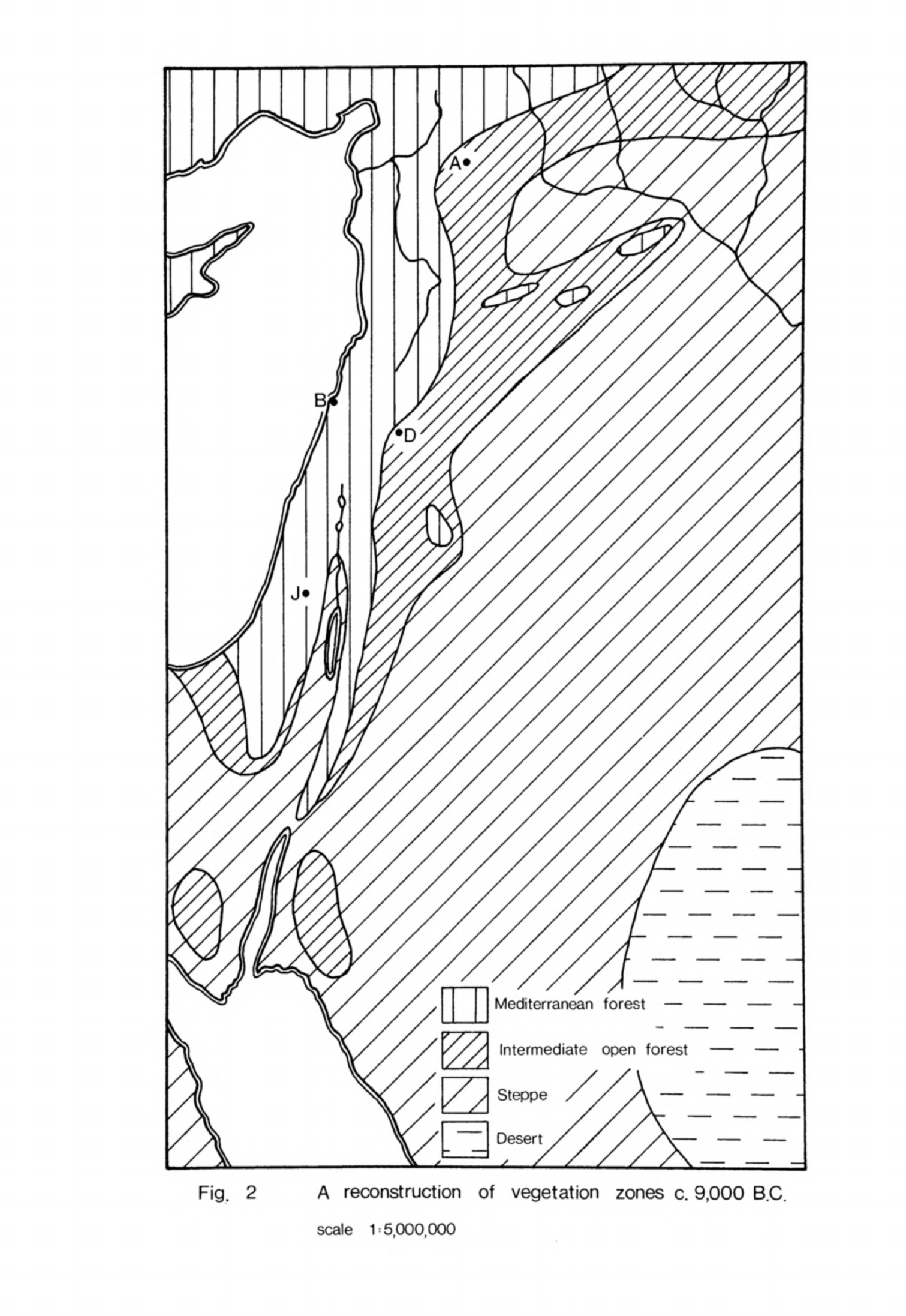
Mediterranean
forest
—
Intermediate
open
forest
Fig.
2
A
reconstruction
of
vegetation
zones
c.
9,000
B.C.
scale
1:5.000.000
-
2U
-
"been
the
principal
cause
of
"both
the rise
in
lake
levels
and the
spread
of
forest.
This
was
entirely
due
to
an
increase
in
precipitation
because
we
know
from
the
deep-sea
cores
that the
temperature
worldwide
had
already
begun
to
rise.
This
temperature
rise,
or
at
least
the
effects
of
it,
seems
to
have
taken
place
a
little
later
in
the
Eastern
Mediterranean
and
Red
Sea
as
the
cores
from
there
do
not
indicate
any
significant
warming
much
before
12,000
or
13,000
B.P.
(Vergnaud-Grazzini,
Herman-Rosenberg,
19&9,
fig.
2;
Herman,
1968,
326).
The
presence
of
species
such
as
silver
lime
in
the
hills
around
Damascus
indicates
that
it
was
still
relatively
cool
during
this
phase.
The
date
for the
beginning
of this
moister
phase
is
uncertain
because
the
relevant
14
C
dates
from
pollen
spectra
and
sediments
in
the
Levant
occur
either
well
before
or
sometime after
its
inception.
A
good
estimate
can,
however, be
made
from
data
in
neighbouring
regions.
The
transition
from
zone
X
to
zone
Y
in
the
pollen
spectrum
from
Tenaghi
Philippon
is
dated
at
12,650
±
200
B.C.
GrN-Ul83
(Wijmstra,
1969,
523),
a
date
that
fits
well
with
14C
determinations
from
several
cores
drilled
in
the
area.
A
similar transi-
tion
at
Lake
Zeribar
is
dated
about
12,000
B.C.
In
the
Levant
itself
we
know
that
the
change
took
place
after
a
date
of
16,850
±
195
B.C.
Hv-1725
for
the
regression
phase
in
the
Huleh
basin
and
a
date
of
17,0^0
±
520
B.C.
for
the
same
regression
in
the
Damascus basin.
The
phase
also
began
sometime
before
9^00
B.C.
in
the
Ghab,
a
date
estimated
from
a
14
C
determination
of
8,130
±
55
B.C.
GrN-5810
for
the
transition
from
sub-zone
Z1
to
Z2
in
the
pollen
spectrum
(Niklewski,
van
Zeist,
1970,
7^3,
751ff).
The
rise
in
level
of
the
Dead
Sea
is
dated
7900
±
150
B.C.
and
must
have
begun
sometime
before
that.
A
fair
estimate
for the
beginning
of
this
phase
in
the
Levant
might
be
about
12,000
B.C.
bearing
in
mind
the
dates
from
Tenaghi
Philippon
and
Lake
Zeribar
but
this
may
be
in
error
by
as
much
as
two
millennia.
Although
the
date
for
the
beginning
of
this
phase
is
so
uncertain
the
phase itself
is
clearly
contemporary
with
the
Late
Glacial
in
northern
Europe
(Butzer,
1972,
27^).
This
was
a
complex
period
of
alternate
milder
and
-
25 -
colder
phases.
It
is
not
surprising, therefore,
if
it
is
difficult
to
inter-
pret
the
geomorphological
and
pollen
data
for
this
phase
in
the
Levant.
The
actual
changes
which
these
data
record
need
not
have
happened
at
exactly
the
same
time
so
one
should
not
necessarily
expect
to
be
able to
give
a
single
date
for the
inception
of
this
phase.
Early
Holocene
The
date
for the
end
of
the
Pleistocene
and
beginning
of
the
Holocene
in
northern
Europe
has
been
determined
as
about 8000
B.C.,
one
recent
estimate
being
8300
B.C.
(Butzer,
1972,
530).
This date
is
believed
to
mark
a
sub-
stantial
reduction
of the
glaciers
and
the
draining
of
the
Baltic
Lake.
These
criteria
have
little
relevance
for the
Levant
yet
this date
does
appear
to
coincide
with
certain
environmental
changes
there
that
characterise
the
true
Holocene.
8000
B.C.
may,
therefore,
also
be taken
as
a
convenient
point
at
which
to
divide
the
Pleistocene
and
Holocene
in
the
Levant.
After
a
marked
fall
in
the
9th
millennium
B.C.
the
temperature
rose
again
at
the
beginning
of
the
Holocene
and
continued
to
increase
until
perhaps
as
late
as
3000
B.C.,
certainly
throughout
the
Neolithic.
This
rise
seems
to
have
been
less
irregular
in
the
earlier
Holocene
than
during
the
Late Glacial
but
there
may
still
have
been
minor
fluctuations
that
affected
the
environ-
ment
of
the
Levant.
The
Dead
Sea
remained
at
a
higher
level than
before
for
several
millennia
during
the
early
Holocene.
The
ratio
of
run-off
to
evaporation
was
high
during
this
period
and
an
extensive
bed
of
clay
was
laid
down
in
the
Dead
Sea
basin
(Neev,
Emery,
1967,
28).
During
a
subsequent
drier
phase
a
layer
of
rock
salt
was
superimposed
on
this clay bed.
The
deposition
of
this
rock
salt
is
estimated
to
have
taken
place
between
U500
and
3500
B.C.
Another
phase
of
increased
available
moisture followed
when
a
further
bed
of
clay
was
laid
down;
this
bed
is
dated
by
a
single
llt
C
determination
of 2H60
±
320
B.C.
(Neev,
Emery,
1967
9
28),
The
Beth-Shan
lake
existed
throughout
this
period
-
26
-
but
was
finally
drained
sometime after
3000
B.C.
No
significant
alterations
in
lake
level
during
the
Holocene
have
"been
detected
in
the
Jafr
depression
(Huckriede,
Wiesemann,
1968,
85)
but
changes
were
taking
place
in
the
Damascus
basin.
Here
alternating
drier
and
moister
phases
are
believed
to
have
influenced
the
environment
during
the
Holocene
(Kaiser
et
al.,
1973,
351ff)
although
these
phases
are
not
well
dated.
During
the
middle
Holocene
a
deep
layer
of
calcareous sediments was
deposited
by
heavy
winter
rains
at
Tekieh
in
the
Barada
gorge and
run-off
was
sufficiently
great
to wash
more
sediment
into
the
Damascus
basin
(van
Liere,
1960-61,
5^-K
Nevertheless,
despite
this
evidence
of
erosive
activity,
the
late
Wurm
lake
in
the
Damascus
basin
gradually
shrank
and
divided
into
two to
form
the
present
Hijjane
and
Ataibe
lakes.
This
was
caused
by
an
increase
in
evapora-
tion
following
the
Holocene
rise
in
temperature
and
an
eventual
decrease
in
effective
run-off.
The
rise
in
sea-level
towards
the
end of
the
Pleistocene
sharply
reduced
the
gradient
of
the
rivers
on
the
seaward
side
of the
Jebel
Alawiye.
The
valleys
of
the
Nahr
el
Kebir
and
the
other
smaller
rivers
began
to fill
with
debris
(van
Liere,
1960-61,
2U).
The
erosive
power
of
the
run-off
in
this
region
has
not
been
very
strong
during
the
Holocene
so
this
deposit
has
continued
to
accumulate
and
little
sediment
reaches
the
sea.
The
evidence
for
changes
in
vegetation
in
the
Levant during
the
Holocene
is
less
satisfactory
than
for
the
Pleistocene.
Very
few
pollen
cores
have
been
drilled
and
studied
while
those
which
are
available
are
difficult
to
interpret.
This
is
true even
in
the
northern
Jordan valley
where
no
less
than
five
cores
have
been
bored
in
Holocene
sediments,
three
in
the
Huleh
basin
(K-Jam,
U.P.6,
U.P.15)
and
two
in
the
bed
of
the Sea
of
Galilee
(D-1016/2,
D-1021/1).
Unfortunately
the
cores
were
sampled
at
rather
wide
intervals
and
relatively
few
pollen
grains
were recovered
(Horowitz,
1971
9
259).
1If
C
determinations have
been
made
on
samples
from
only
three
of
the
five
cores,
K-Jam,
U.P.15
and
D-1016/2.
The
K-Jam
date
(Hv-1725) falls
in
-
27
-
the
Pleistocene
but
the
other
dates
cluster
in
the
second
half
of
the
Holocene.
Because
of
this
uneven
distribution
one
must
treat
with
caution
Horowitz's
calculations
of
average
sedimentation
rates
in
the
cores,
particularly
when
he
applies the
supposed
rate
in
the
dated
core
U.P.15
to
U.P.6
although
the
lithology
in
the
two
is
completely
different
(Horowitz,
19T1»
269).
One's
misgivings
are
reinforced
on
observing
that
some
of
the
dates
applied
to
different
stages
in
the
cores
have
been
incorrectly
calculated
from
the
supposed
sedimentation
rates
(Horowitz,
1971»
268).
Even
when
one
allows
for
these
discrepancies
one finds
that,
on
Horowitz
f
s
own
division
of
the
stages,
the
results
from
the
cores
are
in
part
contradictory.
In
spite of
these
difficulties
it is
necessary
to
attempt
to
analyse
the
data
presented
in
this
study
because
it
provides
almost
the
only indepen-
dent
evidence
about
the
Holocene
vegetation
in
this
region;
the
other
source
of
data,
evidence
from
archaeological
sites,
may
be
expected
to
be
influenced
by
man's
activities.
K-Jam
is
a
much
deeper
core
than
the
others
and
it
is
only
the
section
from
18
to
9m
which
is
believed
to
record
the
vegetation
in
the
first
half
of
the
Holocene
(Horowitz,
1971,
267).
At
18m
the
percentage
of
arboreal
pollen,
principally
oak,
is
relatively
high
but
then
this
gradually
declines.
At the
same
time pollen of
marsh
plants
and
grasses
increases,
reflecting
a
gradual
contraction
of
Lake
Huleh.
A
more
detailed
picture
of
Holocene vegetation
changes
may
be
obtained
from
core
D-1016/2.
This
core
is
thought
to
have
been
drilled
entirely
in
Holocene
sediments
(Horowitz,
1971»
270ff)
and
samples
for
pollen
analysis
have
been
taken
at
shorter
intervals
of time
than
in
the
K-Jam
core.
A
sample
at
the
bottom
of
the
core
from
a
depth
of
30m
below
the
surface
of
the
lake,
which
is
believed
to
date
from
the
beginning
of
the
Holocene,
has
a
low
value
of
10%
for
arboreal
pollen
composed
mostly
of
oak
with
a
little
Aleppo
pine.
Open
field
species
are
much more
common,
accounting
for
over
55%
of the
pollen
(Horowitz,
1971»
diagram
p.
266).
Horowitz
believes
that
these
figures
are
supported
by
the
pollen
spectra
of
the
other,
undated
core
from
the
Sea
of
-
28
-
Galilee,
D-1021/1
(1971,
table
16).
These
results
directly
contradict
the
evidence
from
the
K-Jam
cores
which
suggested
that
Galilee
was
well-forested
at
the
"beginning
of
the
Holocene.
Subsequently
the
values
for
arboreal
pollen
increase
in core
D-1016/2,
reaching
a
peak
between
27
and
23m,
a
little
before
the
middle
of the Holocene.
The
proportions
of
oak
pollen
in the
spectra
have actually
declined
but
walnut
and
jujube
make
up
the
difference.
Open
field
pollen
still
forms an
important
percentage
of
the total.
Again
it
would
appear difficult
to
reconcile
this
curve
for
arboreal
pollen
with
that
from
the
K-Jam
core.
The
two
other
cores
from
the
Huleh
basin, U.P.6
and
U.P.15,
are
believed
to
extend
back
only
as
far
as
the
earlier
Holocene
(Horowitz,
1971,
268ff).
The
percentages
of
arboreal
pollen
are
quite
high
at
the
bottom
of
these
cores,
possibly
correlating
with
the
relatively
high
values
we
have
noted
for
the
earlier
Holocene
in
core
D-1016/2.
The
pollen
is
mostly
from
oak
trees
with
a
little
pistachio
and
olive
but
no
jujube;
the
high
values
for
the
latter
species
in
the
D-1016/2
core
may
be
anomalous.
Can
the
often
apparently
conflicting
evidence
from
these
cores
be
brought
together
to
present
a
coherent
picture
of
vegetation
change?
Part
of
the
difficulty may
be
that
the
record
from
the
K-Jam
core
is
a
long
one
and
insensitive
to
short-term
variations.
The
evidence
from
this
core
suggests
a
steady
decline
in
forest
vegetation
as
the
Holocene
progresses,
a
general
trend
apparent from
the
arboreal
pollen
curves
in
the
two
other
Huleh
cores,
though
not
fully
supported
by
the
evidence
from
the
cores
from
the
Sea
of
Galilee.
The
low
arboreal
pollen
values
for the
beginning
of
the
Holocene
in
core
D-1016/2
may
refer
to
a
short-term
fluctuation
in
that
area
which
has
not
been
noticed
in
the
more
generalised
studies
of
the
K-Jam
core.
One
may
now
present
with
due
caution
a
synthesis
of
the
vegetation
record
from
these
cores.
At
the
close
of
the
Pleistocene
when
the
Huleh
lake
was
quite
extensive
the
hills
of
Galilee
and
the
Golan
were
clothed
with
forest
composed principally
of
oak.
At
the
beginning
of the
Holocene
there
may
have

-
29
-
been
a
brief
decline
in
forest
cover,
at
least
in
the
environs of the
Sea
of
Galilee,
but
thereafter
the hills
were
forested
until
the
mid-Holocene.
This
long
period
of
fairly
extensive
tree
cover
in
northern
Palestine
coin-
cides
with
the
phase
of
greater
run-off
that
maintained
the
Dead
Sea
at
a
high
level.
Later
in
the
Holocene
most of the
cores
show
a
decline
in
tree
pollen
and,
in
the
Huleh
basin,
an
extension
of
marsh
vegetation
which
Horowitz
believes
can
be
attributed
to
generally
drier
conditions
(1971,
268).
It
would
seem
more likely
by
this
time
that
man
was
partly
responsible
for
these
vegetation
changes
through
forest
clearance.
If
this
interpretation
is
correct
for
Galilee
and
the
Golan
then
one
may
tentatively
infer
from
it
something
of
the
pattern
of
vegetation
further
south.
It
is
likely
that
the
Judean
hills
and
the
mountains
of
TransJordan
were forested
at
least
as
far
south
as
the latitude
of
the
Dead
Sea
and
probably
further.
Timber
from
a
number
of
species
from
the
forested
zone
such
as
ash,
plane,
almond,
pear,
olive,
fig,
Christ's
Thorn
and
carob
was
used by
the
Neolithic
inhabitants
of
Jericho
(Western,
1971
9
fig.
1).
This
suggests
that
the
Mediterranean
forest
lay
nearer
the
site
than
it
does
today
(Western,
1971,
Uo).
Northern
Sinai
would
have
been
affected
by
the
moister
conditions
that
existed
in'Egypt
and
so
probably
had
a
richer
vegetation
in
the
earlier
Holocene
than
now.
This
was
almost
certainly
the
same
vegetation
of steppe
and
scat-
tered
trees
that
existed
in
the
area
at
the end
of
the
Pleistocene.
Only
when
more arid
conditions
returned
after
6000
B.C.
would
the
vegetation
have
deteriorated,
a
gradual
process
that
has
continued
until
the
present
day.
Even
now
a
few
relict
specimens of
trees
are
to be
found
in
favoured
habitats
in
both
Sinai
and
TransJordan
(Zohary,
1962,
5*0
though
the
vegetation
zones
of
which
they
were
characteristic
have
retreated.
There
is
very
little
evidence
from
which
to
determine
the
vegetation
in
Lebanon
and
southern
Syria
during
the
Holocene.
Presumably
the
Mountains
of
Lebanon
remained
heavily
forested
for
several
thousand
years.
A
single
pollen
-
30
-
spectrum
from Tekieh
suggests
that
the
Anti-Lebanon
still
carried
some trees
and
herbaceous
ground
cover
as
late
as
the
mid-Holocene
(Kaiser
et
al.,
1973,
fig.
6).
Further
east
steppe
vegetation
characterised
by
Chenopodiaceae
and
Compositae
began
to encroach
upon
the
Damascus
basin
and
the
Golan
(Leroi-
Gourhan,
1973,
U6)
quite
early
in
the
Holocene
but
it
is
likely
that
man's
activities
hastened
this
transformation.
The
principal
source
of
information
for
the
vegetation
of
northern Syria
during
the
earlier
Holocene
is
the
Ghab
pollen
core.
Sub-zone
Z3 in
the
pollen
diagram
is
ascribed
to
this
period
(Niklewski,
van
Zeist,
1970,
750).
Jebels
Alawiye
and Zawiye
remained
clothed
with
light
mixed
forest
throughout
this
period.
The
forest
was
principally
composed
of
evergreen
oak,
olive,
pine
(Pinus
brutia),
pistachio
and
hornbeam
with
some
cedar
of
Lebanon.
There
was
less
oak
pollen
in
this
sub-zone
than
in
Z2
and
a
higher
percentage
of
herba-
ceous
pollen.
This
may
indicate
that
the
tree
cover
was
less
dense
than
in
Z2
and
that
rainfall
decreased
slightly
(Niklewski,
van
Zeist,
1970,
750)
in
the
early Holocene.
Almost
the
same
type
of
light
forest
would
be
the
natural
vegetation
cover
in
this
area
today
were
it
not
for
man's
interference.
Later
in
the
Holocene
species
such
as
pistachio,
olive,
juniper
and
hornbeam
de-
creased
while
cedar
disappeared
completely
because
of
man's
activities
(Wiklewski,
van
Zeist,
1970,
751).
The
vegetation
around
Abu
Hureyra
during
the
earlier
Holocene
was
steppic
but
still
richer
in
species
than
today
(Hillman,
1975,
70).
This
would
indicate
that
the
total rainfall
was
probably
about
the
same
as
now
although
it
may
have
been
more
regular.
The
drastic
degradation
of
the
steppe
that
occurred
during
the
Holocene
around
Abu
Hureyra
and
throughout
northern
and
central
Syria
was
brought
about more
by
man's
activities
than
by
climatic
change.
It
will
be
useful
now
to
compare
the
data
we
have
already
considered
with
recent
proposed
reconstructions
of
postglacial
atmospheric circulation
in the
northern
hemisphere.
During
the
9th
millennium
atmospheric
circulation
is
believed
to
have
been
relatively
weak
over
Europe
and
it
is
thought
that
the
-
31
-
belt
of
-westerly
winds
lay
further
south than
today
(Lamb,
1971
9
Rain-bearing
winds
from
the
Atlantic
and
Mediterranean
would
have
reached
the
Levant
more
frequently
(Lamb,
Woodroffe,
1970
9
figs.
10b,
10c)
and
so
winter
rainfall
would
have
been
greater
than
today;
it
is
also
possible
that
the
rainy season
lasted
longer
than
now.
By
about
6500
B.C.
the
European
ice
sheet
had
almost
disappeared
but
the
North
American
one
still
existed.
This
stimulated
a
more vigorous
wind
system
and
also
caused
the
westerlies
over
the
Atlantic
to
follow
a
more
north-easterly
course.
A
strong
anticyclone
lay
in
the
eastern
Atlantic
and
over
western
Europe
(Lamb,
1971,
160,
figs.
8,
9),
preventing
some
of
the
moist
air
from
the
Atlantic
reaching
the
Levant.
In
consequence
rainfall
became
more
seasonal
and
possibly
decreased
in
amount;
the
continued
post-
glacial
rise
in
temperature
would
have
also
tended
to
lower
precipitation.
About
UOOO
B.C.
the
North American
ice
sheet
had
melted
so
the
wind
system
resumed
a
more
zonal
configuration
but
now
the
track
of
the
westerlies
f
lay
further north
(Lamb,
1971,
160,
fig.
10;
Lamb
et
al.,
1966,
fig.
11g).
The
Levantine
summer
became
longer
and
drier
while
fewer
rain-bearing
depressions
penetrated
from
the
west
in
winter.
Consequently
this
was
a
relatively
arid
period.
Subsequently
the
atmospheric
circulation
fluctuated
again
(Lamb,
1971»
l60ff)
and
this
led
to
an
amelioration
of
climatic
conditions
in
the
Levant
during
the
following
millennia.
Summary
We
can
now
summarise
the
evidence
for
climatic
change
in
the
Levant
during
the
earlier
Holocene
and
see
what
effect
it
had
on
the environment.
After
a
brief
cooler phase
at
the
close
of
the
Pleistocene
the
temperature
resumed
its
rise.
The
rainy season was
both
more
regular
and
lasted
longer
than
today.
Total
rainfall
remained
relatively
high
although
there
is
some
evidence
from
the
pollen
cores
that
it
decreased
slightly
in
northern
Syria
and
possibly
further
south.
These
relatively
cool,
moist climatic
conditions
kept
the
Dead
Sea
at
a
high
level
and
led
to
significant erosion
in
the
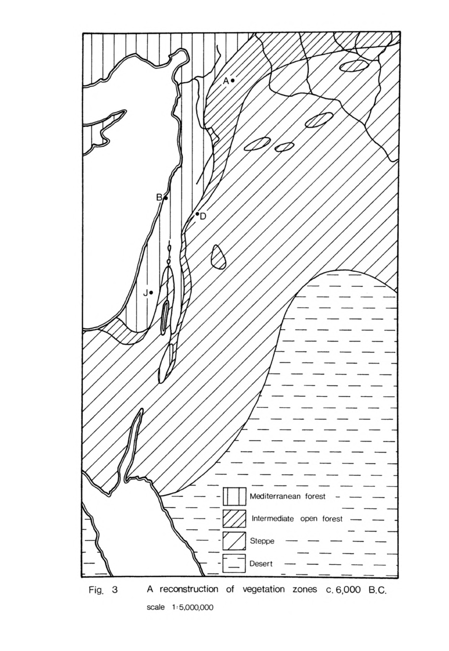
Mediterranean
forest
Intermediate
open
forest
Desert
—
—
—
Fig.
3
A
reconstruction
of
vegetation
zones
c.
6,000
B.C.
scale
1
=
5,000,000
- 32 -
Damascus
basin.
In
Egypt
conditions
were
also
moister
than
today,
causing
the
Arminna
member
to
be
formed
in
Nubia.
Because
the
climate
was
cooler
and
moister
the
Mediterranean
forest
zone
covered
a
larger
area
than
it
would
now
without
human
interference.
Palestine
and
Trans
Jordan
were
clothed
in a
mixed
forest
which extended further
south
than
today.
This
changed
to
open
forest
in
northern
Sinai
while
much
of
the
rest
of
the
peninsula
had
steppe
vegetation
with
scattered
trees.
Further
north
the
Mountains
of
Lebanon were
heavily
forested while
the
Anti-Lebanon
carried
light
woodland.
The
mixed
forest
extended
throughout
the
Jebels
Alawiye
and
Zawiye,
curving
eastward
about
the
latitude
of
Aleppo.
Beyond
the
Mediterranean
forest
zone
lay the
intermediate
open
forest
belt
which
stretched
from
as
far
south
as
the
Dead
Sea
along
the
plateau
of
Trans-
jordan into
northern
Syria.
To
the
east this
belt
merged
with
the steppe
zone
which occupied
much
of the
interior
and
part
of
Sinai.
The
desert
zone
still
covered
a
very
small
part
of
the
Levant,
in
contrast
with
today
(Zohary,
During
the
7th
millennium
the
climate
changed;
rainfall
became
more
seasonal
and
probably
diminished.
This
caused
a
gradual
contraction
of
the
Mediterranean
mixed
forest
and
intermediate
open
forest
zones
(Fig.
3).
The
steppe
expanded
into
areas
that
previously
carried
open
forest
while
the
desert,
too,
reached
further north
and
west.
The
Ghab
and
other
pollen
cores
indicate
that
these
changes
were
accelerated
by
man's activities.
Another
change
in
climate
took
place
during
the
5th
millennium
when
rainfall
in
the
Levant
decreased
further;
it
had
already
fallen
to
almost
nothing
in
Egypt.
By
now
the
temperature
had
risen
to
near
its
postglacial
maximum.
This
deterioration
in
climate
seems
to
have
been
quite
marked
for
it
caused
the
level
of
the
Dead
Sea
to
drop sharply.
The
effect
on
the
vegetation
would
have
been
to
cause
a
further
contraction
of
the
forest
zones
(Fig.
U).
The
desert
albeit
with
some
relict
trees,
would
have
now
extended
throughout
Sinai,
eastern
Trans
Jordan
and
southern
and
eastern
Syria.
It
is

Mediterranean
forest
Intermediate
open
forest
Fig.
4
A
reconstruction
of
vegetation
zones
c.
4,000
B.C.
scale
1:5,000,000

-
33 -
difficult
to
determine
precisely
the
boundaries
of
the
natural vegetation
zones
because
man's
activities
had
already
distorted
the
picture.
The
climate
improved
somewhat
late
in
the
Uth
millennium
but
by
now
the
damage
done
to
the
vegetation
by
man
and
increased
aridity,
particularly
in
the
zones
of
open
forest
and
park
steppe,
was
irreversible.
While
the
climatic
changes
that
took
place
in
the
Levant
in
the
early
Holocene
were
not
as
great
as
during
the
Wtirm
they
were
sufficient
to alter
both
landforms
and the
extent
of
the
major
vegetation
zones.
At
the
moment
it is
possible
only to
describe
these
environmental
changes
in
outline
but
the
evidence
of the
pollen
cores
and
the
sediments
of
the
Damascus
basin
suggest
that events
were
more
complex
than
the
scheme
presented
here.
The
actual
fluctuations
in
rainfall
and
temperature
may
have
been
relatively
small
compared
with
the
postglacial
in
northern
Europe
but
they
had
a
marked
effect
on
the
environment
because
so
much
of
the
southern
Levant
and
the
inland
plateau
is
a
semi-arid
zone
sensitive
to
slight
climatic
changes.
The
evidence
of the
Zagros
pollen
cores
emphasises
that
the
present
climate
and
natural
vegetation
zones
in
the
Near
East
were
not
established
until
the
Holocene
was
well
advanced.
The
changes
in
natural
environment
that
took
place
during
the
earlier
Holocene
would
have
significantly influenced
human
settlement
and
economy.
For the
first
time
man's
own
activities
had
a
marked
effect
on
the
landscape,
particularly
its
vegetation
and
soil
cover.
The
environmental
changes
that
took
place,
therefore,
were caused
by
a
complex
interaction
of
climatic
change
and
human
behaviour.
Chapter
2
THE
MESOLITHIC
OF
THE
LEVANT
The
Mesolithic
of
the
Levant
was
a
distinct
cultural
stage
which
came
betweeb
the
Aurignacian
and the
Neolithic.
Its
most
diagnostic
archaeological
feature was
a
chipped
stone
industry
characterised
"by
microlithic
tools.
This
microlithic
component
has
been
found
on
Mesolithic
stations
all
over
the
Levant
but
on
no
Aurignacian
or
Neolithic
site.
It
is
thus
the
most
distinctive
trait
by
which
to
define
the
Mesolithic
stage.
Mesolithic
sites
were
first
discovered
in
Palestine
and
the
cultural
sequence
has
since
been
established
more securely
there
than anywhere
else.
The
earliest
group
of
these
sites
determined
on
the
evidence
of
stratigraphy
and
comparative
typology
was
called
Kebaran
after
the site
where
this
phase
was
first
defined
in
excavation
by
Turville-Petre
(1932,
271).
The
second
phase
was
called
Natufian
since
its
type-site,
Shukbah,
was
situated
in
the
Wadi
en-Natuf
on
the
western
edge
of
the
Judean
hills
(Garrod,
19^2,
1).
The
information
obtained
from
these
excavations
was
considerably
augmented
in
later
years
in
further
work
by
Garrod
herself
at
the
Mugharet
el
Wad
(Garrod,
Bate,
1937,
9ff),
by
Neuville
at
several
sites
in
the
Judean
desert
(1951,
86ff),
Stekelis
and
his
collaborators
at
En
Gev
(Bar-Yosef,
1970a,
106)
and
Perrot
at
Ain Mallaha
(Eynan)
(1968,
col.
367).
Much
other
information
about
Mesolithic
sites
in
Palestine
has also
been
found
in
recent
surveys
and
excavations.
I
must
now
explain
why
I
have
called
this
stage
"Mesolithic"
since
this
term
is
not
widely
used
at
present
in
Near
Eastern
archaeology.
The
Kebaran
and
Natufian
were
described
as
Mesolithic
from
their
discovery
until
sometime
after
the
Second
World
War
(Turville-Petre,
1932,
276;
Garrod,
1957a,
211).
Objections
to
this
term
have
recently
been
raised by
a
number
of
archaeologists
Braidwood,
for
example,
has
said
that
there
was no
Mesolithic
in
western
Asia
in
the
sense
that
the
term
is
used
in
northern
Europe
(Braidwood, Howe,
1960,
-
35
-
U,
81).
Perrot
(I966a,
U83)
and
Bar-Yosef
(1970a,
1)
have
also
rejected
the
term;
they
prefer
to
call
this
stage
"Epipalaeolithic"
to
emphasise
that
the
microlithic
industries
developed from
the
Aurignacian.
At
a
conference
in
London
in
1969
a
number
of
archaeologists
accepted
this
reasoning
and
agreed
to
use
this
name
in
future.
I
believe
that
the
exclusive
use
of
"Epipalaeolithic"
has
a
number
of
disadvantages.
While
I
-would
agree
that
there
was
continuity
from
the
Aurignacian
to
the
Kebaran,
this
term
implies
that
there was
an
absolute
break
between
the
Natufian
representing
the
end
of
the
Palaeolithic
and
the
Neolithic.
It
is
clear
now,
however,
that
human
occupation
of
the
Levant
continued
straight
through
from
the
Natufian
to
the
earlier
Neolithic.
"Epipalaeolithic"
also
implies
that
the
Kebaran
and
Natufian
had
more
in
common
in
their
artifacts
and
way
of
life
with
the
immediately
preceding
Aurignacian
than
with
the
Neolithic.
It
will
be
seen
from what
follows
that
I
would
strongly
challenge
this
assumption.
This
was
an
important
inter-
mediate
stage
in
the
human
settlement
of
the
Levant
distinct
from
both
the
Palaeolithic
before
and
the
Neolithic
after.
Further,
it
coincided
with
the
final
cold
phase
of
the
Pleistocene
and
its
immediate
aftermath
so
that
the
environmental
setting
was
different
from
the
preceding
and
succeeding
stages,
the
contrast
between
the
Kebaran
and
Aurignacian
landscapes
being
particularly
marked.
This
stage
needs
to
be
described
by
a
term
that
suitably
expresses
its
distinctive
qualities.
I
prefer
to
return
to
earlier
usage and
to
use
"Mesolithic"
to
describe
these
phases,
the
Kebaran
and
Natufian
in
Palestine
and
contemporary
sites
elsewhere
in
the
Levant.
The
Mesolithic
has
been
more
thoroughly
investigated
in
Palestine
than
in
any
other
region
of
the
Levant.
A
few
Mesolithic
sites
had
long
been
known
in
Lebanon
and
Syria
but
their
number
has
grown
markedly
in
recent
years.
Several
of
these
sites
have
now
been excavated
so
that
the
sequence
in
these
regions
has
also
been
determined,
at
least
in
outline.
For
many
years
the
Nebekian
and
Falitian
levels
excavated
by
Rust
at
Yabrud
III
were
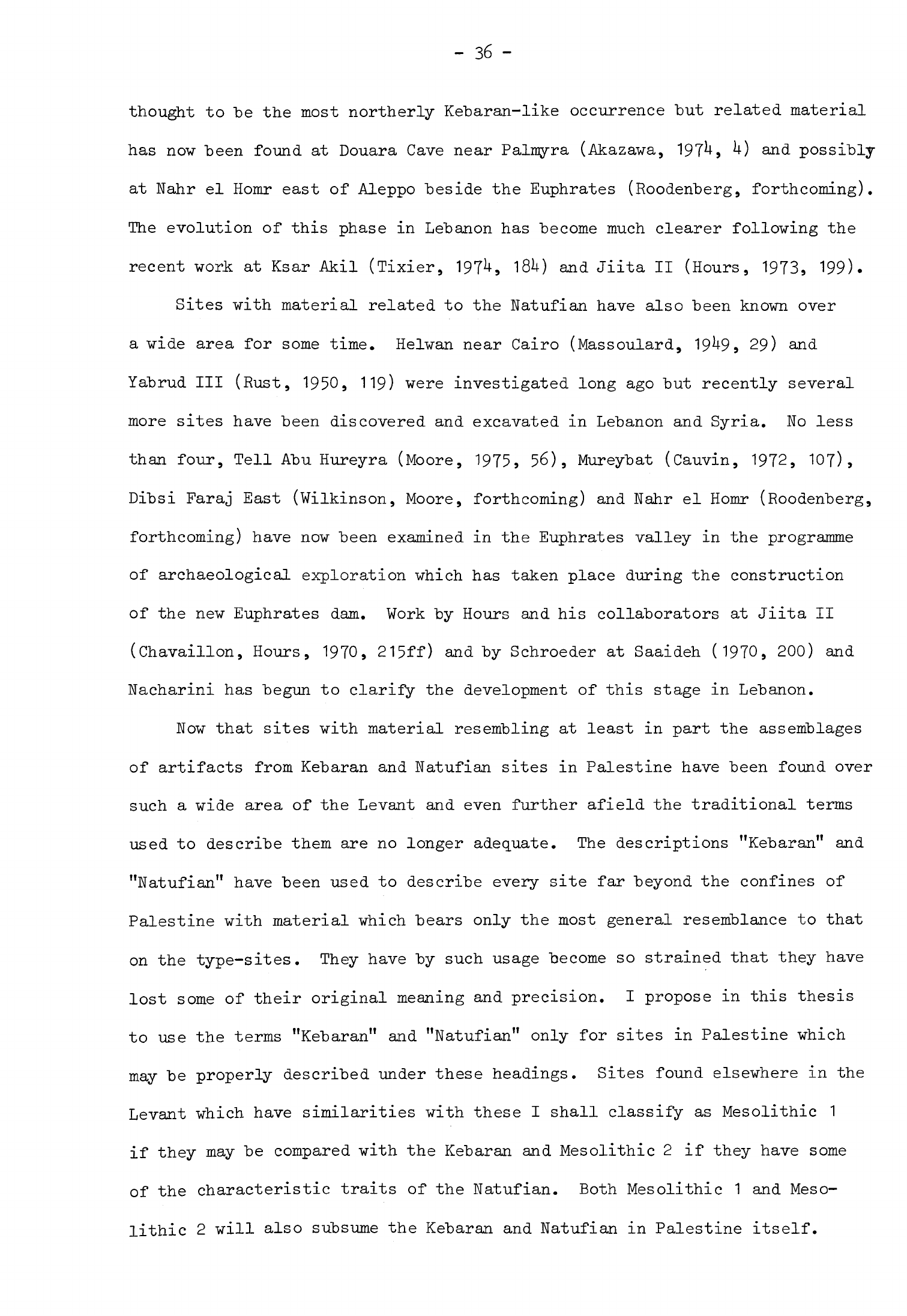
-
36
-
thought
to
be
the
most
northerly Kebaran-like
occurrence
but
related
material
has
now
been
found
at
Douara
Cave
near
Palmyra
(Akazawa,
197^-,
^)
and
possibly
at
Nahr
el
Homr
east
of
Aleppo
beside
the
Euphrates
(Roodenberg,
forthcoming).
The
evolution
of
this
phase
in
Lebanon
has
become
much
clearer
following
the
recent
wort
at
Ksar
Akil
(Tixier,
197^,
1W
and
Jiita
II
(Hours,
1973,
199).
Sites
with
material related
to
the
Natufian
have
also
been
known
over
a
wide
area
for
some
time.
Helwan
near
Cairo
(Massoulard,
19^9»
29)
and
Yabrud
III
(Rust,
1950,
119)
were
investigated
long
ago
but
recently
several
more
sites
have
been
discovered
and
excavated
in
Lebanon
and
Syria.
No
less
than
four,
Tell
Abu
Hureyra
(Moore,
1975,
56),
Mureybat
(Cauvin,
1972,
107),
Dibsi
Faraj
East
(Wilkinson,
Moore,
forthcoming)
and
Nahr
el
Homr
(Roodenberg,
forthcoming)
have
now
been
examined
in
the
Euphrates
valley
in
the
programme
of
archaeological
exploration
which
has
taken
place during
the
construction
of
the
new
Euphrates
dam.
Work by
Hours
and
his
collaborators
at
Jiita
II
(Chavaillon, Hours,
1970,
215ff)
and
by
Schroeder
at
Saaideh
(1970,
200)
and
Nacharini
has
begun
to
clarify
the
development
of
this
stage
in
Lebanon.
Now
that
sites
with
material
resembling
at
least
in
part
the
assemblages
of
artifacts
from
Kebaran
and
Natufian
sites
in
Palestine
have
been
found
over
such
a
wide
area
of the
Levant
and
even
further
afield
the
traditional
terms
used
to
describe
them
are
no
longer
adequate.
The
descriptions
"Kebaran"
and
"Natufian"
have
been
used
to
describe
every
site
far
beyond
the
confines
of
Palestine with
material
which
bears
only
the
most
general
resemblance
to
that
on
the
type-sites.
They
have
by
such usage
become
so
strained
that
they
have
lost
some
of
their
original
meaning
and
precision.
I
propose
in
this
thesis
to
use
the terms "Kebaran" and "Natufian" only
for
sites
in
Palestine
which
may
be
properly
described
under these
headings.
Sites
found
elsewhere
in
the
Levant
which
have
similarities
with
these
I
shall
classify
as
Mesolithic
1
if
they may be
compared
with
the
Kebaran
and
Mesolithic
2
if
they
have
some
of
the
characteristic
traits
of
the
Natufian.
Both
Mesolithic
1
and
Meso-
lithic
2
will
also
subsume
the
Kebaran
and
Natufian
in
Palestine
itself.

-
37
-
Mesolithic
1
Mesolithic
1
throughout
the
Levant
followed
the
Aurignacian
or
Levantine
Upper
Palaeolithic.
The
Aurignacian
was
divided
into
three phases
"by
Neuville
(1951,
260,
table
1)
called
Upper
Palaeolithic
III,
IV and
V,
the
last
being
transitional
between
the
Aurignacian
and
the
Mesolithic.
Garrod
believed
that
the
Aurignacian
of
the
Levant
did not
sufficiently
resemble
the
Aurignacian
of
Europe
to
justify
using
the
name
so
she
introduced
the
terms
Lower
and
Upper
Antelian
(Garrod,
1957b,
UUo)
to
describe
stages
III
and
IV
of
Neuville.
She
also
invented
another
term,
Athlitian,
to describe
the
material
from
Mugharet
el
Wad
which
roughly
corresponded
with
Neuville
f
s
transitional
phase
V
(Garrod,
Bate,
1937,
M).
Copeland
has
recently
introduced new
terms
to
describe
the
material
from
Lebanon
and
Syria
using
Ksar
Akil
as
the
type-site
(1975,
3^2).
She
uses
Levantine
Aurignacian
phase
C
for
Ksar
Akil
Levels
8
to
6
which
corresponds
very
approximately
to
Neuville's
stage
V.
This
phase
is
marked
by
very
varied
assemblages
at
most
sites
on
which
is
occurs,
empha-
sising
its
transitional
nature.
It
seems
fairly
certain
that
Mesolithic
1
developed
directly from
the
Aurignacian.
There
are
indications
that
a
gradual
change
took
place
in
the
stone industries.
Microliths and
retouched
bladelets
are
found
for
the
first
time
in
the
Aurignacian
deposits
of
El
Khiam
E
(Perrot,
1951, 1^1),
Kebara
D
(Garrod,
195
1
*,
177)
and
Ksar
Akil
(Copeland,
1975,
3^3).
Two
sites
at
least,
Ksar
Akil
and
Yabrud
III,
seem
to
have
fairly
complete
sequences
that
span
the
transition
from
Aurignacian
to
Mesolithic
1.
Perrot
has
also
claimed
a
degree
of
continuity from
level
E
to
D
at
El
Khiam
(1951,
1^9)
while
at
Kebara
itself
no
break
was
detected
in
the
stratigraphy
between
D
and
C
(Garrod,
195U,
186)
although
the
Athlitian
was
missing
here.
On
the
other
hand
there
was
a
break
in
the
sequence
between
the
Aurignacian
and
the
Kebaran
at
Nahal
Oren
(Bar-Yosef,
1970a,
37ff)
while
at
Mugharet
el
Wad
there
was
no
Kebaran
occupation
at
all
after
the
Aurignacian
of
layer
C.
Such
breaks
may
partly

-
38
-
be
a
reflection
of
the
way
of
life
of
the
inhabitants
of
these
sites.
It
is
probable
that
such
groups
used
sites
intermittently
over
several
years
and
then left
them
unoccupied
for
long
periods.
The stone
industries
from
Athlitian
sites
are
so
diverse
typologically
that
Bar-Yosef
has
questioned
even
the
existence
of
this
phase
(1970a,
26).
Others
believe
that
a
number
of
sites
can
be
included
in
this
stage
despite
the
differences
between
them
(Hours
et
al.
a
1973,
273).
Such
sites
would
be
Mugharet
el
Wad
C,
El
Khiam
E,
the
Nahal
Oren
terrace
and
Ksar
Akil
6.
Changes
of
some
kind
were
taking
place
at
this
time
which
manifested
themselves
in
the
stone
industries
first
of
Athlitian
sites
and
then
of
Mesolithic
1.
The
latter
with
its
large
proportion
of
microliths
is
very
different
from
the
Aurignacian.
Several
factors
brought
about
these
changes.
One
of
the
most
crucial
was the
abrupt
deterioration
in
climate
and
environment
that
set
in
about
20,000
or
18,000
B.C.
when
the
last
cold
phase
of
the
Pleistocene
began.
We
have
seen
that
the
Levant
became
relatively
arid and
the
forest
vegetation
retreated
to
be
replaced
by
steppe.
The
inception
of
this
cool,
dry
phase
just
preceded
the
beginning
of
Mesolithic
1
on
present
evidence.
The
hunter-
gatherers
of
the
Aurignacian
would
have
had
to
modify substantially
their
way
of
life,
particularly
their
settlement
pattern,
to
take
account
of
changing
conditions.
This
shift
to
a
new
adaptation may
be
responsible
for
the
confused
nature
of
Athlitian
deposits.
The
crystallization
of
this
new
pattern resulted
in
Mesolithic
1;
not
only
was
the
settlement
pattern
modi-
fied
but
a
new
stone
industry
of
distinctive
character
was
developed.
The
inhabitants
of
the
small
Mesolithic
1
sites
found
in
the
Levant
left
behind
little
more
than
their
chipped
stone
tools.
Any
definition
of
the
Kebaran
thus
rests
upon
a
description
of the
characteristic
features
of
this
chipped
stone
industry
(Bar-Yosef,
1970a,
l68ff;
Hours
et
al.,
1973,
^52).
The
industry
was
essentially
one
of small
tools
made
on
bladelets
struck
off
single-platform
cores.
Much
of
the
waste
also
consisted
of
bladelets.

-
39
-
There
were
rarely
more
than
a
few
"blades
on
any site,
in
contrast
with
the
Aurignacian.
The
most
numerous
and
typical
tools
were non-geometric
microliths
particularly
microgravettes
9
"backed
bladelets
and
"backed
truncated
"bladelets.
The
only
other
tools
found
with
any
frequency
were
end-scrapers
and
"burins.
A
few
bone
tools
and
some
of
ground
stone
have
been
found
on
Mesolithic
1
sites
but
little
else.
Before
considering
the
distribution
and
nature
of
Mesolithic
1
sites
I
will
present
the
little
information
we
have
about
the
chronology
of
this
stage.
Mesolithic
sites
are
far less
numerous than
those
of
the
Neolithic
and only
a
few
have
been
dug
recently.
Of
these
not
all
have
yielded
material
suitable
for
carbon
1U
dating
so
that
there
is
a
dearth
of
chronological
data.
Those
dates
which
are
available
suffice
only
to
fix
Mesolithic
1
approximately
in
time
and
to
establish
its
duration.
Following standard
practice
all
14
C
dates
I
shall
quote
in
this
thesis
will
be
calculated
on
the
Libby
half-life.
In
sometimes
differ
by
as
much
as
several
centuries
from
the
absolute
age
of
the
samples
which
they
date.
At
present
it
is
not
possible
to
estimate
except
in
the most
general
way
the
absolute
age
of
dated
samples
since
the
whole
Mesolithic
and
much
of
the
Neolithic
lie
beyond
the
range
of
the
calibration
curves
published
so
far.
I
discuss
this
question
more
fully
in
the
Appendix
but
it
should
be
pointed
out
here
that
uncorrected
dates
still
provide
a
sound
sequence
of
relative
chronology.
Carbon
1^
is
the
only
method
of
near
absolute
dating
that
has
been
used
for
archaeological
sites
and
contemporary
environmental
phenomena
during
the
Mesolithic and
Neolithic
in
the
Levant
so
that
chronological
data
from
these
two
sources
may
be
directly
compared
to
build
up
as
complete
a
picture
as
possible
of the
evolution
of
human
society
in
the
Levant
during
these
stages.
In
order
to
determine
when
Mesolithic
1
began
it
is
necessary
to
consider
dates
from
sites
occupied
late
in
the
Aurignacian
and
also
the
few
Kebaran
sites
in
Palestine
from
which
14C
determinations
are
available.
presenting
the
determinations
in
this
form
I
recognise
that
they
will
-
ho
-
There
is
one
date
of
26,890
±
380
B.C.
GrN-2195
(Radiocarbon
5,
1963,
173)
from
level
8
at
Ksar
Akil.
This
is
supported
by
new,
as
yet
unpublished,
dates
for
slightly
later
material
from
the
site
(Tixier,
quoted
in
Copeland,
1975,
3^3)
but
these
dates
are
believed
to
be
rather
early
for
such
a
late
stage
in
the
Aurignacian.
The
other
dates
are
all
from
Ein
Aqev,
an
Aurig-
nacian
site
in
the
Negev.
The
samples
for
these
determinations
were
collected
in
stratigraphies!
order.
From
bottom
to
top
they
are:
18,080
±
1200
B.C.
SMU-5,
15,^0
±
560
B.C.
SMU-8,
15,9^0
±
600
B.C.
SMU-6
(Radiocarbon
16,
197^,
378,
379),
15,560
±
290
B.C.
1-5^95
and
1^,950
±
250
B.C.
1-5^9^
(Radiocarbon
15,
1973,
295).
Again
these
determinations
are
almost
consistent
internally.
The
Ein
Aqev
dates
pose
a
problem
because
most
of
them
overlap
vith
the
earliest
dates
now
available
from Kebaran
sites.
At
En
Avdat
only
3.5
km
from
Ein
Aqev
there
is
a
site
(D5)
classed
as
Geometric
Kebaran
A
which
has
given
the
following
dates:
16,890
±
680
B.C.
SMU-7
(Radiocarbon
16,
197^,
379),
13,870
±
1730
B.C.
Tx-1121
(Radiocarbon
1U
9
1972,
hQh)
and
11,220
±
230
B.C.
1-5^97
(Radiocarbon
15,
1973,
296).
This
is
not
a
very
satisfactory
series:
SMU-7
is
considered
suspect
by
the
excavator
of
the
site
because
it
seems
so
much
earlier
than
the
other
dates
and
Tx-1121
has
such
a
large
standard
error
that
it
could
really
be
much
earlier
or
later.
It
remains
possible,
however,
that
En
Avdat
does
have
some
occupation
deposits
dating
from
early
in
Mesolithic
1.
Two
sites
in
northern
Palestine,
Nahal
Oren
and
Rakafet,
have
Kebaran
levels
that
are
dated
very
early.
From
Rakafet
there
is
a
single
determination
of
16,960
±
330
B.C.
1-6865
(Noy
et
al.,
1973,
96).
This
is
supported
by
one
date
from
Nahal
Oren
of
16,300
±
320
B.C.
UCLA-1776C
from
layer
IX
(Noy
et
al.,
1973,
77)
near
the
beginning
of
the
Kebaran
sequence
on
the
site.
There
are
also
later
dates
in
the
sequence
of
1U,930
±
3^0
B.C.
UCLA-1776B
and
13,850
±
300
B.C.
UCLA-1776A
(Noy
et
al.,
1973,
77).
This
series
of
dates
is
consistent
and
the
standard
errors
are
small.
The
layers
dated
by
1-6865
and
UCLA-1776C
are
not,
however,
thought
to
be
at
the
very
beginning
of
the
-
in
-
Kebaran
sequence
in
this
region
(Noy
et
al.,
1973,
96).
The
Nahal
Oren
dates
in
particular
suggest
that
Mesolithic
1
began
"before
17,000
B.C.
and
possibly
as
early
as
18,000
B.C.
in
Palestine
and
perhaps
Lebanon.
The
Ksar
Akil
dates
would
not
preclude
the
possibility
that
it
began
earlier
still.
This
estimate
would
include
the
En
Avdat
dates
but
does
not
resolve
the
problem
of
those
from
Ein
Aqev.
It
is
possible,
of
course,
that
Mesolithic
1
began
somewhat
later
in
the
Negev.
It
should
be
borne
in
mind,
however,
that
the
flint
industries
of
the
Aurignacian
and
Mesolithic
1
in
the
Negev
do
not
resemble
very
closely
those
from
further
north
in
the
Levant.
When
the
assemblages
from
En
Avdat
(Marks
et
al.,
1971,
20)
and
Ein
Aqev
(Marks,
1973,
U)
are
compared
they
do
not appear
to
be
very
different.
It
may
be
that
both
represent
a
range
of
activities
carried
on
by
similar
groups
over
a
long
period
of
time.
The
change
from
Mesolithic
1
to
Mesolithic
2
can
be
dated
more
closely,
though
still
not
very
exactly.
This
is
because
the
dates
available
from
Mesolithic
1
sites
are
mostly
derived
from
early
phases
in
the
sequence
so
one
has
to
rely
on
dates
from
early
Mesolithic
2
sites
to
arrive
at
an
estimation.
The
latest
date
for
a
Mesolithic
1
site
anywhere
in
the
Levant
is
12,150
±
500
B.C.
MC-U11
(Radiocarbon
15,
1973,
337)
from
Ksar
Akil.
The
earliest
date
from
a
Mesolithic
2
site
is
11,1^0
±
200
B.C.
1-5^96
(Radiocarbon
15,
1973,
295)
from
Rosh
Horesha
in
the
Negev.
This
determina
tion
may
be
inaccurate
as
it
does
not
agree
with
two
others
taken
from
similarly
stratified
samples
at
the
same
site;
those
determinations
are
8,930
±
280
B.C.
SMU-10
and
8,5^0
±
^30
B.C.
SMU-9
(Radiocarbon
16,
197^,
379).
There
are
several
determinations
from
three
other
sites
that
fall
in
the
10th
millennium.
These
are
9,200
±
^00
B.C.
for
Kebara
B,
two
dates
from
Mugharet
el
Wad
B2
of
9,970
±
660
B.C.
and
9,525
±
650
B.C.
(Henry,
1973a,
291)
and
a
date
from
Jericho
of
9,216
±
107
B.C.
P-376
(Radiocarbon
5,
1963,
8U),
although
two
other
samples
from
the
Natufian
deposits
here
have
given
later
dates
of
7,850
±
2UO
B.C.
F-72
and
7,900
±
2^0
B.C.
F-69
(Kenyon,
-
U2
-
1959
j
8).
None of
these
dates
is
entirely
satisfactory:
the
Kebara
and
Mugharet
el
Wad
determinations
were
all
made
recently
on
bones
from
skeletons
excavated
many
years
ago
(Henry,
1973a,
99)
and
the
Jericho
samples
were
processed
when
carbon
1U
dating
was
still
quite
new.
Nevertheless,
this
series
of
dates
forms
a
consistent
pattern
which
suggests that
the
transition
from
Mesolithic
1
to
Mesolithic
2,
in
Palestine
at
least,
took
place
about
10,000
B.C. or
possibly
a
little
before.
This
estimate
can
only
be
approximate
for
the
moment
since
the
evidence
is
so
uncertain;
it
ignores
the
possibility
that
a
version
of
the
Kebaran
continued
on
beside
the
earliest
Natufian
(Bar-Yosef,
1970a,
173).
Settlement
patterns
Mesolithic
1
sites
have
been
found
over much
of
the
Levant
but
their
greatest
density
is
in
Palestine
and
Lebanon
(Fig.
5).
Their
known
distribu-
tion
is
the
result
of
survey
and
excavation,
much
of
it
quite
recent,
which
may
not
necessarily
accurately
reflect
the
original
pattern
of
occupation.
This
has
been
demonstrated
in
Syria
where
no
Mesolithic
1
sites
were
known
north
of
Yabrud
until
a
few
years
ago
when
more
were
found
following
intensive
survey
of
the
Palmyra
region
and
the
Euphrates
valley.
Sites
have
now been located
in
the
Jebel
Meghara
in
northern
Sinai
(Moshabi
XIV)
as
well
as
in
the
Har
Harif
and
in
Nahal
Lavan
(Nahal
Lavan
II,
VI,
105)
in
the
Negev.
Others
have
been
found
along
the
present
coast
of
Palestine
(Kiryath
Aryeh,
Kefar
Darom),
in
the
Judean
hills
(El
Khiam)
,
on
Mb.
Carmel
(Kebara,
Nahal
Oren)
and
in
Galilee
(Hayonim,
En
Gev).
At
least
three
sites
have
been
discovered
in
what
is
now
the
steppe
zone
of
TransJordan
east
of
the
Rift
valley
(Wadi
Dhobai
K,
Wadi
Madamagh,
Wadi
Rum).
In
Lebanon
almost
all
the
known
sites
are on
the
western
slopes
of
the
Lebanon
Mountains
(Abri
Bergy,
Jiita
II,
Ksar
Akil).
Douara
Cave
near
Palmyra
and
Nahr
el
Homr
on the
Euphrates
are
proof
that
Mesolithic
1
communities
inhabited
central
and
northern
Syria
where
there
must
be many
other
contemporary
sites
awaiting
discovery.
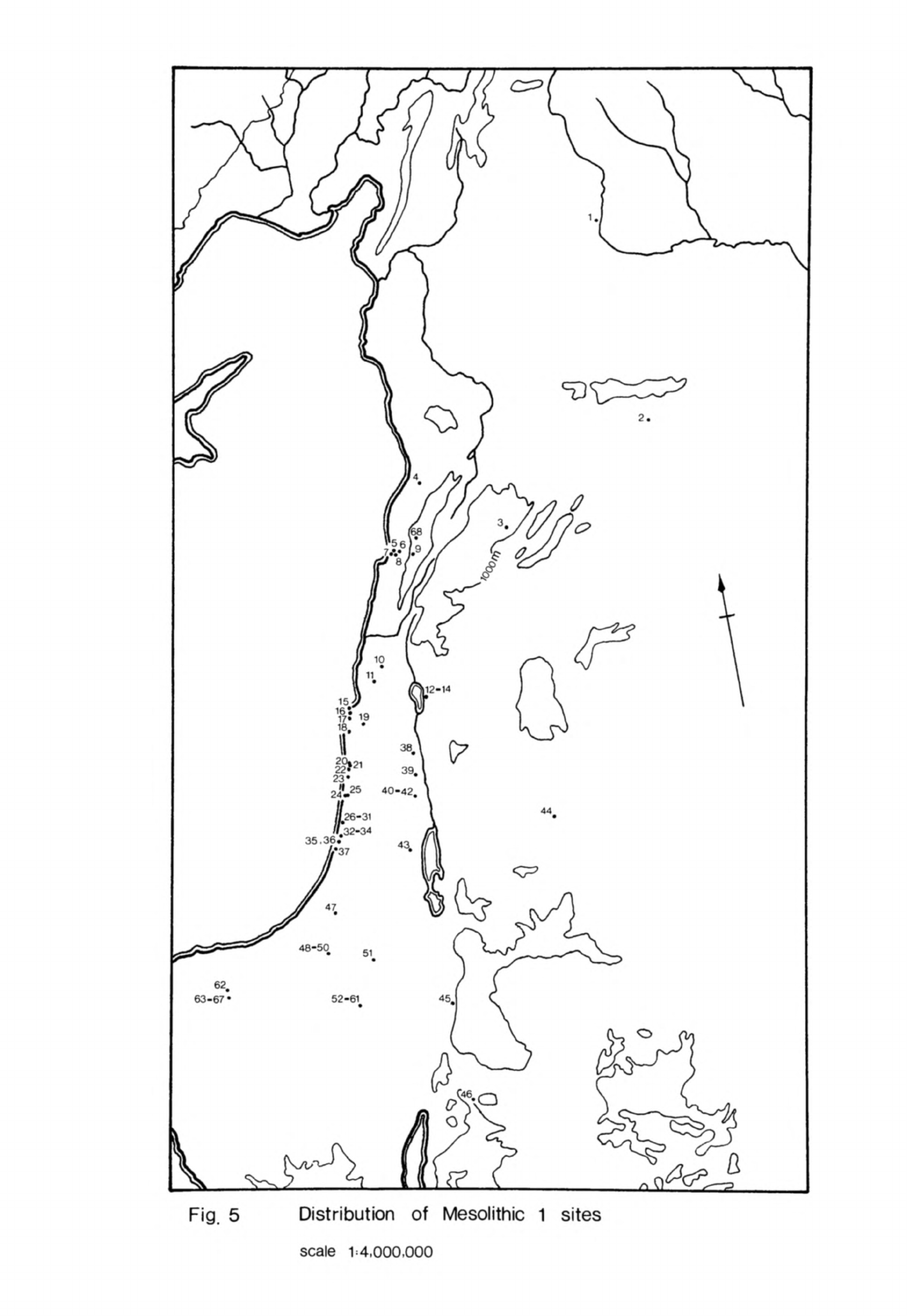
Fig.
5
Distribution
of
Mesolithic
1
sites
scale
1:4,000,000
FIGURE
5
Distribution
of
Mesolithic
1
sites
1
Nahr
el
Homr
(Roodenberg,
forthcoming)
2
Douara
cave (Akazawa, 1974)
3
Yabrud
III
(Rust,
1950,
107)
4
Ash
Ash
(Copeland,
¥escombe,
1966,
24)
5
Jiita
II
(Hours,
1973)
6
Dhour
Choueir
(Hours
et
al,
1973,
454)
7
Ksar
Akil
(Tixier,
1974)
8
Abri
Bergy
(Copeland,
Wescombe,
1965,
62)
9
Ain
Hazir
(Hours
et
al,
1973,
454)
10
Mugharet
el
Abed
(Copeland,
Wescombe,
1966,
47)
11
Hayonim
(Bar-Yosef,
1970a,
42)
12
En
Gev
I
(Bar-Yosef,
1970a, 106ff)
13
En
Gev
II
(Bar-Yosef,
1970a,
106ff)
14
En
Gev
III
(Bar-Yosef,
1970a,
106ff)
15
Haifa
1
(Olami,
1973,
8)
16
Iraq
el
Barud
(Bar-Yosef,
1970a,
32)
17
Nahal
Oren
(Noy
et
al,
1973)
18
Kebara
(Turville-Petre,
1932)
19
Rakafet
(Noy
et
al,
1973,
96)
20
Hofith-68
(Bar-Yosef,
1970a,
63)
21
Kefar
Vitkin
III
(Bar-Yosef,
1970a,
60)
22
Umm
Khalid
(Bar-Yosef,
1970a,
66)
23
Poleg
18MII
(Bar-Yosef,
1970a,
69)
24
Kiryath
Aryeh
II
(Bar-Yosef,
1970a,
76)
25
Kiryath
Aryeh
I
(Bar-Yosef,
1970a,
77)
26
Soreq
33MI
(Bar-Yosef,
1970a,
84)
27
Soreq
33M
(Bar-Yosef,
1970a,
85)
28
Soreq
33G
(Bar-Yosef,
1970a,
85)
29
Soreq
33
M
(Bar-Yosef,
1970a,
86)
30
Soreq
33
M
2
(Bar-Yosef,
1970a,
88)
31
Giveath
Haesev
(Bar-Yosef,
1970a,
89)
32
Kefar
Darom
26
(Bar-Yosef,
1970b,
61)
33
Kefar
Darom
27
(Bar-Yosef,
1970b,
61)
34
Kefar
Darom
28
(Bar-Yosef,
1970b,
61)
35
Kefar
Darom
3
(Bar-Yosef,
1970b,
61)
36
Kefar
Darom
8
(Bar-Yosef,
1970b,
61)
37
Kefar
Darom
13
(Bar-Yosef,
1970b,
61)
38
¥adi
el
Malih
(Bar-Yosef
et_al,
1974,
423)
39
¥adi
Far'ah
(Bar-Yosef
et
al,
1974,
423)
40
¥adi
Fazael
III
(Bar-Yosef
et
al,
1974,
42l)
41
Wadi
Fazael
VII
(Bar-Yosef
et
al,
1974,
420)
42
Wadi
Fazael
VIII
(Bar-Yosef
et
al,
1974,
421)
43
El
Khiam
(Perrot,
1951,
154)
44
¥adi
Dhobai
K
(¥aechter,
Seton
Williams,
1938,
174)
45
¥adi
Madamagh
(Kirkbride,
1958a)
46
¥adi
Rum
(Copeland, Hours,
1971)
47
Point
104
(Perrot,
1968,
col.
365)
48
NaJial
Lavan
II
(Phillips,
Bar-Yosef,
1974&,
477)
49
Nahal Lavan
VI
(Phillips,
Bar-Yosef,
1974a,
477)
50
Nahal
Lavan
105
(Phillips,
Bar-Yosef,
1974a,
478)
51
En
Avdat
D5
(larks
et
al,
1971,
20)
52
Har
Harif
Gl
(Marks
et
al,
1972,
78)
53
Ear
Harif
G3
(Marks
et
al,
1972,
78)
54
Har
Harif
G9
(Marks
et
al,
1972,
78)
55
Har
Harif
G10
(Marks
et
al,
1972,
78)
56
Har
Harif
K4
(Marks
et
al,
1972,
78)
57
Har
Harif
K5
(Marks
et
al,
1972,
78)
58
Har
Harif
K6 (Marks
et
al,
1972,
78)
59
Har
Harif
K7
(Marks
et
al,
1972,
78)
60
Har
Harif
K8
(Marks
et
al,
1972,
78)
61
Har
Harif
K9
(Marks
et
al,
1972,
78)
62
Lagama
I
(Phillips
et
al,
n.d.,
7)
63
Moshabi
XIV
(Phillips,
Bar-Yosef,
1974b,
483)
64
Moshabi
XVII
(Phillips,
Bar-Yosef,
1974b,
483)
65
Moshabi
unnumbered
(Phillips,
Bar-Yosef,
1974b,
483)
66
Moshabi
unnumbered
(Phillips,
Bar-Yosef,
1974b,
483)
67
Moshabi
XIX
(Phillips,
Bar-Yosef,
1974b,
483)
68
Neba'a
el
Mghara
(Copeland,
¥escombe,
1965,
113)

-
U3
-
Relatively
few
Mesolithic
1
sites
have
been
found
in
the
Judean
hills
or
in
the
Mountains
of
Lebanon
even
though
these
areas
have
been
carefully
surveyed.
This
suggests that
the
people
of
Mesolithic
1
avoided
the
wooded
highlands.
The
Kebaran
occupation
at
El
Khiam
and
the
related
Nebekian/
Falitian
at
Yabrud
III
show
that
they
did
penetrate
the
upland
rain-shadow
zone
which
carried thin
woodland
at
most
during
this
period.
TransJordan
and
possibly
Sinai
and
the
Negev
were
all
steppic
yet
Mesolithic
1
sites
have been
found
in
these
regions
so the
steppe
itself
must
have
afforded
resources
which
these
people
could
exploit.
They
do
not,
however,
appear
to
have
deeply
penetrated
the
steppic
zone
to
the
east.
It
may
be
that
the
very
dry,
cool
conditions
of the
interior
inhibited
further
expansion
in
this
direction.
All
known Mesolithic
1
sites
were
probably
north
and
west
of
the
contemporary
200mm
isohyet
which
may
have
been
the
effective
boundary
of
occupation.
It
will
be
interesting
to
see
if
this
observation
still
holds
true
once
the
interior
of
the
Syrian
desert
has
been
more
thoroughly
surveyed.
The
people
of
Mesolithic
1
used
both
rock
shelters
and
open
stations
as
habitation
sites.
The
shelter
sites,
among
them
Ksar
Akil,
Jiita
II,
Hayonim,
Kebara
and
Wadi
Madamagh,
were
frequently
situated
in
wadis
on
the
fringes
of the
hill
country.
Not all the
available
rock
shelters
were
occupied:
Mugharet
el
Wad,
Shukbah
and
Erq
el
Ahmar
for
instance
remained
empty
through-
out
Mesolithic
1.
This
may
indicate
that
shelters
were
now
less
attractive
as
habitation
sites
than
they
had
been
during
the
Aurignacian.
Most
Mesolithic
1
sites
were
open
stations.
Again,
some
like
the
Nahal
Oren terrace
and the
Wadi
el
Malih
and Wadi Fazael
sites
were
situated
in
wadis
while
En
Gev and
others
were
found
near
springs.
There
were
many
more
open
stations
along
the
present
coast
and
in
the
Negev
around
the
Ear
Harif
and
Jebel
Meghara.
Until
recently
the
relative
abundance
of
open
sites
in
Mesolithic
1
compared
with
the
Aurignacian
lent
weight
to
the
suggestion
that
these
were
more
preferred
than
in
the
past.
This
may
still
be
true
of
the
upland
zones
where
shelters
and
caves
were
to
be
found.
This
observation
- hh -
does
not
apply
to
northern
Sinai
and
the
Negev
where
the
recent
survey
work
of
Marks,
Phillips
and
their
collaborators
has
shown
that
these
areas
were
inhabited
in
both
the
Aurignacian
and
Mesolithic
1.
All
the
sites
of
both
stages
found
here
have
been
open
stations
principally,
no
doubt,
because
shelters
were
a
rare
feature
of the
landscape
in
these
regions.
Economy
and
society
The
great
environmental
diversity
of
the
Levant
meant
that
a
wide
range
of
fauna,
flora
and raw
materials
could be
exploited
by
man but
these
resources
would
have
varied
considerably
from
zone
to
zone.
This
diversity
of
resources
is
reflected
in
the
different artifact
inventories
from
supposedly
approximately
contemporary
deposits
on
Mesolithic
1
sites.
The
artifacts
reflect
above
all
the
activities
practised
by
the
inhabitants
and
it
is
reasonable
to
expect
that
these
activities
would
have
varied
according
to
the
resources
available
although
other
factors such
as
human
preference
would
also
have
played
a
part.
The
animal
bones
form
the
largest
and
most
important
category
of
direct
evidence
for
the
economy
of
Mesolithic
1
and
the
varied
collections
from
individual
sites
give some
idea of
the
wide
range
of
resources
that
was
used.
The
catchment
areas
of
the
sites
would
have
contained
a
variety
of
species
in
different
proportions
and
this
environmental
factor
can
be
detected
in
the
excavated
fauna!
remains.
Preliminary
information
from
En
Gev
I
indicates
that
gazelle
comprised
k3%
of
the
bones
of
the
main
food
animals,
deer
(fallow,
red
and
roe
together)
36%
and
ovicaprines
15.5%.
There
were
also
some
cattle
bones
(k.5%)
and
a
little
pig
(1%)
(Bar-Yosef,
1970a,
120ff;
1975,
372
after
Davis)
while
a
number
of other
species,
including
birds,
were
represented
in
small
quantities.
Many
of
these
species
were
also
found
in
En
Gev
II
and
III.
The
fauna
from
the
Kebaran
layers
at
Nahal
Oren
was quite
similar
and
the
species
were
represented
in
much
the
same
order
but
here
the
preponderance
of
gazelle
(11M]
was
even
more
striking.
Fallow
deer
were
second
in
importance
(15.2$)
but
the
other
species
were
much
less
significant:
cattle
3.3%
9
pig
2.6%,
red
and
roe
deer
1.1$
and
goat
hardly
at
all
(0
(Hoy
et
al.,
1973,
table
U).
At
Kebara
itself
gazelle
dominated
the
fauna
in
layer
C
(Saxon,
197^,
fig.
3)
while
fallow
deer
were
much
less
important
than
in
the
Aurignacian.
Other
species
were
killed
only
in
very
small
quantities.
The
pattern
was
similar
at
Hayonim
even
though
the
faunal
sample
was
small.
Gazelle
was
again
the
most
numerous
species (Bar-Yosef,
Tchernov,
1966,
129ff)
with
fallow
deer
second.
Cattle,
red
deer
and
caprines
were
present
in
small
quantities
as
well
as
numerous other
species
of
rodents
and
carnivores.
Hares
were
very
common
and
it
appears that
terrestrial
molluscs
were
also
eaten.
When
the
fauna
from
these
sites
is
compared
it is
clear
that
gazelle
were
eaten
in
much
greater
numbers
in
Palestine
than
any
other
species.
Deer,
especially
fallow
deer,
were
second
in
importance and
hares
seem
to
have
been
a
regular
supplement.
A
wide
range
of
other
species
was
hunted
or
collected
for
food
but
these
were
of
minor
importance
in
the
total
diet.
The
consumption
of
gazelle
rapidly
increased
in
proportion
to
that
of
fallow
deer
after
the
Aurignacian
(Noy
et
al.
a
1973,
fig.
9).
This
trend
continued
throughout
Mesolithic
1
as
the
evidence
from
Nahal
Oren
makes
clear;
fallow
deer
declined from
about
30
or
hO%
in
layer
IX early
in
the
Kebaran
to
1U.9$
in
layer
VII
at
the
end
while
gazelle
increased
reaching
82.6$
in
layer
VI
transitional
between
the
Kebaran
and
Natufian
(Noy
et
al.,
1973,
table
3).
Such
a
pattern
of
exploitation
depended
partly
on
environmental
factors
The
forest
in
central
and
northern
Palestine
thinned
out
in
response
to
more
arid
conditions
during
the
last
cool
phase
of the
Pleistocene.
This
probably
led
to
a
natural
decline
in
the
deer
population
and
a
rise
in
that
of gazelle.
As
gazelle
became
more
plentiful
so
man
hunted
more
of
them
rather
than
other
species
which
were
much
less
numerous.
Legge
has
suggested
that
the
people
of
Mesolithic
1
may
have
practised
"gazelle
husbandry"
(1972,
123;
Noy
et
al..
1973,
91).
Certainly
it
appears
that this
species
was
pursued
more
intensively
and
that
care
was
taken
to
kill
a
high
proportion
of
immature
animals
"but
this
may
have
amounted
to
no
more
than
selective
hunting.
It
is
probable,
however,
that
a
close
dependence
on
gazelle
was
established
at
this
time
and
that this
relationship
was
intensified
later.
This
concentration
on
gazelle was
not
a
universal
pattern
of
exploita-
tion
in
Mesolithic
1.
At
Ksar
Akil,
for
example,
the
percentage of
fallow
deer
killed
was
very
high
(53%),
a
higher proportion
even
than
in
the
Aurignacian
(Hooijer,
1961,
table
25).
Goat
was
second
in
importance
(30$)
and
roe
deer
third
(15$).
Some
cattle
were
taken
(1$)
but
even
fewer gazelle
than
in
the
preceding
stage
(1$).
The
emphasis
on
fallow
deer
throughout
the
Ksar
Akil
sequence
is
as
striking
as
that
of
gazelle
on
sites
in
northern
Palestine
after
the
Aurignacian.
It
must,
equally,
represent
selective,
intensive
hunting
of
the
species
near
the
site
that
was
most
numerous
and
easiest
to
kill.
Goats
(the
bezoar
Capra
hircus
aegagrus
and
beden
Capra
ibex
nubiana)
were
the
main
animals
hunted
at
Wadi
Madamagh
(Perkins,
1966,
67),
their
bones
accounting
for
82.7$
of
the
animal
bones
at
the
site,
although
other
food
animals
such
as
aurochs
(Bos
primigenius),
gazelle,
pig
(Sus
scrofa)
,
an
equid
and
hare
were
also
taken.
Again
one
species
was
much
preferred
to
all
the
others
and
it
was
probably
the
one
that
was
especially
numerous
around
the
site.
Selective
hunting
was
practised
on
most
sites
in
Mesolithic
1,
the
species
chosen
being
those
that
were
readily
available
in
the
vicinity
and
which
provided
ample
meat
and
other
products.
Marine
shells
have
been
found
at a
number
of
inland
Mesolithic
1
sites
such
as
D5
near
En
Avdat
(Marks
et
al.,
1971
5
20),
Wadi Madamagh
(Kirkbride,
1958a,
56)
and En
Gev
I
and
II
(Bar-Yosef,
1970a,
121,
125)
and
also
nearer
the
sea
at
Hayonim
(Bar-Yosef,
Tchernov,
1966,
137).
Many
of
these
were
decorative
objects
brought
up
from
the
Mediterranean
but
some
were
edible
species.
It
seems
likely
that fish
and
molluscs
would
have
been
eaten,
if
-
hi
-
only
in
small
quantities,
where
they
vere
available.
One
instance
of
this
is
En
Gev
where
fish
bones
were
found
at
En
Gev
IV
only,
a
site
transitional
between
Mesolithic
1
and
2,
but
not
at
En
Gev
I,
II
or
III
(Bar-Yosef,
1970a,
109).
The
latter
sites
were
all
in
use
when
the
Pleistocene
Lisan
lake
still
existed.
It
had
much
of
the
character
of
the
Dead
Sea
today
and
fish
could
not
have
lived
in
it.
At
the
close
of
the
Pleistocene
the
Lisan
lake
shrank
and
eventually
the
Sea
of Galilee
was
formed
from
it as
a
freshwater
lake
(Bar-Yosef,
19TOa,
108).
Fish
gradually
established
themselves
and
by
the
time
En
Gev
IV
was
founded
on
its
shore
man
was
able
to
catch
them
for
food.
It
is
possible
that
some
Mesolithic
communities
depended
to
a
much
greater
extent
upon
marine
resources
but
their
sites
will
have
disappeared
as
the
sea
level
rose
at
the
end
of
the
Pleistocene.
During Mesolithic
1
the
sea lay
about
15
km
west
of
the
present
coast
of
Palestine.
There
is
some
archaeological
evidence
that
plants
were
eaten
in
Mesolithic
1.
6h
seeds
were recovered
from
the
Kebaran
levels
at
Nahal
Oren
which
in-
cluded
fig
and
grape
pips
as
well
as
vetch
and
grass seeds
(Noy
et
al.
,
1973,
table
6).
There
is
also
rather
enigmatic
evidence
that
cereals
were
collected
as
one
barley
and
three
emmer
(Triticum
dicoccum)
grains
were
found
in
the
deposits.
One
cannot
unreservedly
accept
the
presence
of
cultivated
emmer
grains
in
such
an
early
deposit
despite
the
apparently
unequivocal archaeolo-
gical
evidence
that
they were
in
situ
(Noy
et
al.,
1973,
93)
until
supporting
evidence
is
forthcoming
from
other
sites.
Not
too
much
should
be made
either
of such
a
small sample
but
it
would
not
be
surprising
if
cereals
were
being
collected
at
this
early
date
as
part
of
the
vegetable
diet.
Further,
it
is
not
impossible
that
emmer,
which
is
present
in some
early
Neolithic
contexts,
was
being
collected
in
the
wild
in
such
a
way
that
a
"domesticated"
form
had
already
developed.
We
do
not
know
what
proportion
of
the
diet
of
the
people
of
Mesolithic
1
consisted
of
vegetable
foods
but
the
probability
is
that they
were
at
least
as
important
as
the
meat
obtained
from
hunting.
Recent
studies
have
shown
that
among
most
contemporary
hunter-gatherers
vegetable
foods
form
a
major
part
of
the
diet.
Australian
aborigines
select
food
from
almost all
edible
plant
and
animal
species
in
their
habitats
but
they
eat
more
vegetable
foods
than
anything
else
(Gould,
1969
9
258;
Yengoyan,
1968,
I86ff).
Woodburn
has
calculated
(1968,
51)
that
80%
of
the
Hadza
diet
by
weight
is
composed
of
vegetable
foods
and
20%
of
meat
and
honey
although
the
calorific
value
of
the
plant
foods
is
proportionately
rather
less.
The
IKung
bushmen
also
eat
similar
quantities
of
vegetable
foods
(Lee,
1968,
33ff,
^0).
It
is
only
in
certain
extreme
environments
where
vegetable
foods
are
rare such
as
the
north-west
coast
of
North
America
(Suttles,
1968,
61,
note
5)
or
the
Arctic
that
man
relies
on
hunting
and
fishing
for
subsistence
(Lee,
1968,
U2)
.
The
wide
range
of
plant
and
animal
foods
available
to
man
in
the
Levant
is
typical
of
many
other
regions
in
lower
latitudes
where
hunter-gatherers
now
and
in
the
recent
past
have
subsisted
on a
largely vegetable
diet
though
eating
a
great
variety
of
other
foods
from
time
to
time.
It
seems
highly
probable
that
this
was
also
the
case
in
Mesolithic
1;
vegetable
foods
were
almost
certainly
collected
and
eaten
in
quantity
and
may
have
formed
the
basis
of
the
diet.
The
artifacts
and
technology
of
Mesolithic
1
communities
differed
significantly
from
those
of
the
Aurignacian.
The
most
obvious
development
was
in
the
chipped
stone
industries
although
the
innovation
of
microlithic
tools remains
difficult
to
interpret
in
the
Levant
where
there
is
no
accom-
panying
evidence
of
a
major
change
in
the
basis
of
subsistence.
One
of
the
new
tools
was
the
sickle
blade
(Bar-Yosef,
1970a,
156),
that
is
a
blade
with
gloss
on
the
cutting
edge.
This
was
quite
a
rare
tool
on
Mesolithic
1
sites,
as
were
blades
and
blade
tools
in
general.
The
gloss
on
the
edge
indicates
that
the
tool
was
used
for
cutting
plants
with
siliceous
stalks,
reeds,
cereals
or
the
like.
This
innovation
signifies
that
specialised
stone
tools
were
being
developed
to
process
plants,
though
there
is
no
indication
yet
that
anything
resembling
conscious
agricultural techniques
was
being
practised.
One
other
new
group
of
tools
was
stone
pestles,
mortars
and
grinders.
These
were
found
first
at
En
Gev
then
recently
at
a
number
of
other
Mesolithic
1
sites
(Bar-Yosef,
1975,
368).
Stone
grinders
have
been
found
at
the
Aurignacian
site
of
Ein
Aqev
in
the
Negev
(Marks,
1973,
M
but
it
appears
that these
tools
were
first
made
in
quantity
during
Mesolithic
1.
We
do
not
know
if
they
were
used
in
some
new
industrial
process
or
for
crushing
plant
foods
but
the
development
of
such
tools
is
significant
not
only
as
a
technological
innovation
but
because
they
were
the first
bulky,
heavy
items
made
by
man
in
the
Levant.
They
would
have
been
an
impediment
to
mobile
groups
and,
as
such,
were
harbingers
of
a
later
more
sedentary
existence.
We
know
the
area
of
some
Mesolithic
1
sites
and
from
this
it is
possible
to
estimate
approximately
the
number
of
people
which
inhabited
them.
When
this
information
is
combined
with
the
data
we
have
for
their
economy
it
enables
us
to
reconstruct
in
outline
the
social
structure
of
these
human
groups.
Some
sites
were
very
small
indeed;
Nahal Lavan
VI
was
15
sq
m
and
Nahal
Lavan
II
UO
sq
m
(Phillips,
Bar-Yosef,
197^a,
1*77)
while
Hofith-68
(75
sq
m)
and
Kefar
Darom
28
(70
sq
m)
were
only
a
little
bigger
(Bar-Yosef,
1970a,
63,
92).
Most
of
the
other
sites
for
which
we
have
information
were
between
120
and
300
sq
m
in
area.
Wadi
Madamagh
was
originally
about
120
sq
m
(Kirkbride,
1958a,
55ff)
and
the
Mesolithic
1
occupation
at
Jiita
II
about
130
sq
m
.
The
maximum
extent
of
site
D5
at
En
Avdat
in
the
Negev
was
also
130
sq
m
(Marks
et
al.,
1971,
20).
Moshabi
XIX
was only
a
little
larger
(160
sq
m)
(Phillips,
Bar-Yosef,
197^b,
U83)
but
Moshabi
I
was
almost
twice
as
big
(300
sq
m)
(Phillips
et
al.,
n.d.,
8).
The
estimated area
of
Kebara
itself
was
the
same
as
Moshabi
I
(Garrod,
195^-,
156ff, pi.
XXIII).
The
total
area
of
occupation
at
Kefar
Darom
8,
500
sq
m
(Bar-Yosef,
1970a,
102),
is
apparently
greater
but
as
it
is
thought
that
this site
was
used
over
a
long
period
the
total
area
occupied
at
any
time
was
probably
less
and
so
within
the
range
of
the
other
sites.
One
site,
Ksar
Akil,
may have
been
bigger
than
the
others
I
have
mentioned
since
the
total
area
of
the
shelter
-
50
-
2
and
terrace
in
front
was
well
in
excess
of
500
sq
m
.
The
area
occupied
in
Mesolithic
1
may
have
been
500
sq
m
or
more
but
we
do
not
have
enough
information
about
the
excavations
at
Ksar Akil
to
be
sure.
While
the
size of
camps
used
by
hunter-gatherers
today
varies
widely,
they
frequently
come
within
the
same
range
as
Mesolithic
1
sites.
It
is
known
that
camps
of
Australian
aborigines
are
often
from
200
to
300
sq
m
in
area
while
Bushmen
camps
may
be
a
little
larger,
ranging
from
230
to
790
sq
m
(Isaac,
1968,
258).
These
are
open
sites
in
which
groups
of
the
same
size
might
be
expected
to
occupy
a
slightly
larger area
than
in
a
cave.
These
groups
or
bands
have
20
to
30
members
and
groups
of
this
size
are
commonly
found
among
hunter-gatherers
today.
Using
data
from
the
Birhor,
IKung
Bushmen
and
some
Australian
aborigines
Birdsell
has
suggested
(1968,
235)
that
the
average
band
has
25
members.
Steward
has
found
(1968,
331)
that
this
is
also
true
for the
Athapaskans,
Hadza
and
Western
Shoshoni.
Given
that
Mesolithic
1
sites are
approximately
the
same
size
as
those
used
by
groups
of
hunter-gatherers
today
it
seems
likely
that
the
basic
unit
of
social
organization,
a
band
of
about
25
people,
was
also
about
the
same.
It
is
possible
to
suggest
in
a
little
more
detail
how
these
bands
may
have
been
organized.
Some years
ago
in
a
discussion
of
social
organization
among
primitive
peoples
Service
stated
that
most
hunter-gatherers
today
were
grouped
in
patrilocal
bands
(1962,
65).
He
also
believed
that
this
type
of
social
structure
was
characteristic
of
prehistoric
hunter-gatherers
(1962,
10Tff).
Recent
research
has
demonstrated
that this
particular
band
structure
is
much
less
common than
was
previously
supposed
(Lee,
De
Vore,
1968,
Tff)
and,
indeed,
Service
has
considerably
modified
his
earlier
views
(1971,
157).
It
is
now
clear
that
Primary
(Steward,
1968,
331)
or
Composite
(Lee,
De
Vore,
1968,
8)
bands
are
more
typical
of
hunter-gatherer
societies
today.
Bands
of
this
type
may
fluctuate
considerably
in
size
but
usually
consist
of
about
25
individuals.
The
members
will
be
related
to
each
other
but
there
is
great
variety
in
the
kinship
structure.
-
51
-
This
form
of
social
organization
has
considerable adaptive
advantages.
Composite
bands
are
small
so
they
do
not
rapidly
exhaust
the
food
supply
in
the
vicinity
of
their
camps,
They
are
also
extremely
flexible:
they
can
move
easily
from
one
camp
to
another
in
order
to
exploit
fresh
resources
and
can
also
split
up
or
amalgamate
to
adapt
to
seasonal
variations
in
food
supply.
This
type
of adaptation
is
well-suited
to
a
region
such
as
the
Levant
with
very
varied
geographical
conditions
and
seasonal
differences
of
climate,
vegetation
and
fauna.
Such
a
model
of
social
organization
fits
the
archaeological
evidence
for
Mesolithic
1
quite
well.
While
it
is
no
doubt
oversimplified
and
will
need
modification
when
more
evidence
is
available,
I
believe
it
indicates
in
outline
how
society
was
organized
in
Mesolithic
1.
Although
most
Mesolithic
1
sites
fall
within
the
same
size range
as
camps
of
composite bands
of
hunter-gatherers
today
a few,
as
we
have
seen,
were
smaller
than
the
average,
that
is
less
than
100
sq
m
in
area.
Such
sites
were
too
small
to
have
accommodated
a
complete
composite
band.
They
may
have
been
the
camps
of
single
families
or
small
hunting
parties
which
had
separated from
a
band.
Some
sites
from
100
to
200
sq
m
were
inter-
mediate
in
size
between
these
transitory
stations
and
the
larger
camps;
they
may
have
been
used
by
two
or
three
families
or
groups
smaller
in
size
than
the
full
composite
bands.
All
Mesolithic
1
sites
and
thus
the groups
which
inhabited
them
were
in
general
quite
small
particularly
when
compared
with
some
Mesolithic
2
camps
and
earlier
Neolithic
settlements.
Some
information
about
the
internal
arrangements
of
Mesolithic
1
sites
has
been
recovered
in
excavations
at
En Gev
which
enables
us
to
deduce
in
a
little
more
detail
the
organization
of
Mesolithic
1
communities.
Excavations
here
revealed
four
sites
in
close
proximity,
three
of
them
Kebaran
(En
Gev
I,
II,
III)
and
one
transitional
between
the
Kebaran
and
Natufian
(En
Gev
IV).
En
Gev
I
was
150
sq
m
in
area
but
the
density
of
stone
tools
found
suggests
that only
50
sq
m
was
intensively
occupied
-
52
-
(Bar-Yosef,
1970a,
182).
En
Gev
II
was
very
small
but
may
have
been
inhabited
about
the
same
time
as
En Gev
I
(Bar-Yosef,
1970a,
182),
so
these
two
sites
came
within
the
size
range
of
the
intermediate
sites
discussed
above.
En Gev
I
consisted
almost
entirely
of
a
large
round
hut
5
to
7m
in
diameter
floored
with
pebbles
(Bar-Yosef,
1970a,
figs.
89,
90)
with
associated
hearths
and
occupation
debris.
En
Gev
III
probably
represented
a
similar
hut
(Bar-Yosef,
1970a,
fig.
102)
while
En
Gev
IV
was
also
apparently
a
habitation
structure
(Bar-Yosef,
1970a,
126).
These
large,
single
structures
suggest
that
each site
may
have
been
occupied
by
an
extended
family
rather
than
a
band
composed
of
several
families.
The
total
number
of
people
in
the
group
was
probably
less
than
the
average
of
25 or
so
suggested
for
composite
bands,
perhaps
no
more
than
10
or
15.
A
little
more
evidence
for
a
similar
type
of
small
camp
has
now
been
found
at
Moshabi
XIV
in
the
Jebel
Meghara
(Phillips,
Bar-Yosef,
197^b,
1*83).
A
pit
dwelling
has
been
discovered
here
associated
with
post-holes
and
hearths.
This camp
would
appear
to
resemble
those
at
En
Gev
and may
have
been
inhabited
by
a
group
of
similar
size.
Most
Mesolithic
1
sites
have
very thin
occupation
deposits
indicating
that
they
were
occupied
briefly
perhaps
on
a
seasonal
basis. The
presence
of
amphibian
species
but
not
reptiles
in
the
fauna
from
Hayonim
may
be
taken
as
evidence
that
the
cave
was too
wet
in
the
winter
for
human
occupation
(Bar-Yosef,
Tchernov,
1966,
138);
it
was
probably
only
inhabited
during
the
summer.
The
absence
of
certain
rodents
closely
associated
with
man
is
a
further indication
that
human
occupation
was
intermittent
during
Mesolithic
1.
The hut
at
En
Gev
I
had
six floor
levels
separated
by
sterile
sand
(Bar-
Yosef,
1970a,
110),
clear
evidence
that
the
structure
was
repeatedly
occupied
for
short
periods
of
time.
En
Gev
III
seems
to
have
had
a
similar
series
of
floor
levels (Bar-Yosef,
1970a,
12U,
fig.
102),
emphasising
that
this
was
a.
regular
practice
over
several
years.
Composite
bands
or
smaller
groups
may
have
lived
on
each site
for
a

-
53
-
short
time,
varying
between
a
few
days
and
several
weeks,
until
the
easily
available
food
in
the
neighbourhood
began
to
diminish.
They
would
then have
moved
on to
a
new
site.
On
modern
analogy
their movements
would
probably
have
taken
place
within
a
defined
area
or
territory
and
may
have
been
re-
stricted
by
the
presence
of
other
groups
who
were
exploiting
neighbouring
territories.
This
pattern
of
movement
would
have
been
related
to
the
marked
seasonal
variation
in
resources
typical
of
the
region.
The
length of
time
spent
at
each site
would
have
varied
during
the
year
depending
on
the
resources
available
in
the
vicinity.
A
band
might
have
returned
to
certain
favoured
sites
regularly
for
a
few
years
but
then
have
moved
away
into
a
new
territory.
Although
Mesolithic
1
sites
were
usually
insubstantial,
clusters
of
them
have
often
been
found
together,
as
around
Nahal
Poleg
(Burian,
Friedmann,
196U-6U,
10ff),
Kefar
Darom,
En
Gev itself and
in
Wadi
Malih.
These
areas
were
sufficiently
attractive
for
the
people
of
Mesolithic
1
to
visit
them
frequently.
The
same
was
probably
also
true
of
some
of
the
shelter
sites
with
more
substantial
occupation
deposits
such
as
Ksar Akil
and
Jiita
II,
themselves
close
together,
and
Yabrud
III.
Higgs
has
suggested
that
trans-
humance
may
have
been
practised between Nahal
Oren
and
Rakafet
(Noy
et
al.,
1973,
95ff).
This
would
have
been
a
specialised
form
of
seasonal
movement
between
a
lowland
and
an
upland
site
quite
near
each
other
which
offered
complementary
resources.
Such
a
pattern
of
movement
may
have
been
typical
o'f
some
other
areas
of
the
Levant
where
contemporary
sites
have
been
found
only
a
short
distance
apart
in
different
environmental
zones.
This
practice
may
have
begun
much
earlier
during
the
Palaeolithic
as
has
been
postulated
for
Epirns
in
Greece
(Higgs
et
al.,
1967,
l8ff).
The
constant
movement
that
was
one
of
the
dominant
features
of this
way
of
life
would
have imposed
a
severe
constraint
on
the
rate
of
population
growth.
The
mothers
would
be
unable
to
look
after
more
than
one, or
at
the
most
two,
infants
at
a
time
and
so
could
only
support
children
born
at
least
three
years
apart.
Without
some
form
of
birth
control
children
would
often
be born
more frequently
than
this
so
some
other
limitation
would
be
necessary,
The
solution
adopted
among
many
hunter-gatherers
today
is
infanticide
(Birdsell,
1968,
236ff)
while
among communities
in
extreme
environments
even
more
severe
demographic
controls
are
exercised
(Balikci,
1968,
81).
Where
infanticide
is
not
practised
a
high
infant
mortality
rate
severely
restricts
population
growth
(Rose,
1968,
203ff).
By
means
of
these
and
other
constraints
the
Mesolithic
1
population
would
have
remained
stable
or
grown
only
very
slowly
indeed.
On
modern
analogy
it
would
have
remained
for
much
of
the
time
well
below
the
maximum
carrying
capacity
of
the
region.
Mesolithic
2
Archaeological
evidence
from
sites
in
Palestine
and
on
the
Lebanese
coast
suggests
that
Mesolithic
2
developed
directly
from Mesolithic
1.
At
Kebara,
Nahal
Oren,
Hayonim
and
Jiita
II
the
Mesolithic
2
layers
were
stratified
immediately
above
those
of
Mesolithic
1
without
any
serious
break
in
the
sequence.
There
were
also
enough
similarities
in
the
cultural
equip-
ment
of the
two
stages
from
these
and
other
sites
to
indicate
that
Mesolithic
2
developed
directly
from
Mesolithic
1,
at
least
in
these
regions.
Both
the
microliths
and
the
heavy
component
of
the
flint
industries
of
both
stages
had
many
types
in
common;
only
the
lunate,
one
of
the
type-fossils
of
Mesolithic
2,
was
really
new.
Certain
technological
traits
such
as
the
microburin
technique
were
shared
by
many
Mesolithic
1
and
Mesolithic
2
sites
while
the
same
types
of
heavy
stone
tools,
pestles,
mortars
and
querns
were
present
in
each
stage.
It
would
also
appear
that
the
huts
at
En
Gev
I
and
III
were
the
ancestors
of
the
characteristic circular
Mesolithic
2
buildings.
The
sequence
of
sites
at
En
Gev
illustrates
the
transition
from
Mesolithic
1
to
Mesolithic
2
as it
took
place
in one
favoured
settlement
location. Sites
I
and
II
here
have
been
classified
as
"Kebaran"
and
therefore
quite
early

-
55
-
in
the
Mesolithic
1
sequence,
site
III
as
"Geometric
Kebaran
A"
which
is
thought
to
have
been
a
little
later,
and
site
IV
as
"Geometric
Kebaran
A2"
or
"B"
(Bar-Yosef,
1975,
368ff);
this
last
phase
may
be
regarded
as
transitional
or
even
a
variant
of Mesolithic
2.
It
is
only
in
the
central
Levant
that
we have strong
evidence
for
an
uninterrupted
transition
from Mesolithic
1
to
Mesolithic
2
although
there
is
some
additional
evidence
from
other
sites
as
far
south
as
the
Negev
to
Yabrud
III
in
the
north.
Elsewhere
in
central
and
northern
Syria
and
in
the
semi-arid
areas
to
the
east
not
enough
is
known
yet
about
contemporary
sites
for
one
to
be
certain
that
their
development
was
similar.
The
Natufian
in
Palestine
may
be
defined
by
a
number
of
cultural
attributes.
The
most
important
of
these
is
a
microlithic
chipped
stone
industry
of
which
the
lunate
is
the
most
characteristic
type;
this
stone
industry
may
include
many
coarse
flake
tools
on
some
sites.
Heavy
ground
stone tools
such
as
mortars,
pestles and rubbers
are
another
typical
feature,
Some
other
traits
are
also
characteristic,
among
them
a
rich
bone
industry,
certain
bone
and
shell
beads
and
art
objects
which
include
both
human
and
animal
figurines.
Circular
stone
buildings
sometimes
associated
with
stone
paving
have
also
been
found
on
some
sites
and
may
be
regarded
as
another
attribute.
Most or
all
of
these
traits
have
been
found
on
the
large
sites
such
as
Erg
el
Ahmar
(Neuville,
1951
9
86),
Mugharet
el
Wad
(Garrod,
Bate,
1937,
29ff)
and
Ain
Mallaha
(Perrot,
1968,
col.
367)
in
central
and
northern
Palestine.
It
is
in
this
region
which
may
be
regarded
as
the
Natufian
heartland
that
the
Natufian
was
most
developed.
Many
smaller
sites
in
this
area
were
also
Natufian
in
aspect
although
for
functional
or
other
reasons
they
may
have
lacked
some
of
the
characteristic
artifacts.
Most
of
the
typical
Natufian
traits
have
also
been
found
on
the
larger
sites
in
the
Negev.
Both
Rosh
Zin and
Rosh
Horesha
had
circular
buildings and
a
typical
Natufian
flint
industry
(Marks,
1975a,
353).
A
number
of
ground
stone

-
56
-
rubbers
and
querns
were
also
found
at
Rosh
Zin
(Henry,
1973b,
130) as
well
as
other
diagnostic
traits.
The
material
from
these
sites
is
so
similar
to
that
on
sites
further
north
that
it
is
reasonable
to
include Rosh
Zin
and
Rosh
Horesha within
the
Natufian
as
defined
above.
Mesolithic
2
sites
in
Lebanon
and
south
Syria,
Jiita
II
(Chavaillon,
Hours,
1970,
230),
Jiita
III
(Copeland,
Wescombe,
1965,
92)
and
the
Beirut
Sands
stations
(Copeland,
Wescombe,
1965,
129,
13*0
on
the
coast;
Amiq
II
(Hours
et
al.
,
1973,
^66)
and
Jebel
Saaideh
(Schroeder,
1970, 200)
in
the
Beka'a;
Nacharini,
Yabrud
III
(Rust,
1950, 119),
Mugharet
el
Abde
(Nasrallah,
1951,
92ff),
Qornet
Rharra
(de
Contenson,
1966a,
199)
and
Saidnaya
(van
Liere,
de
Contenson,
1963,
179)
in
the
Anti-Lebanon;
and
Taibe
(M.-C.
Cauvin,
197^a,
U69)
in
the
Hauran
had
relatively
few
characteristic
Natufian
traits.
All
of
them
lacked
buildings
which
may
be
because
they
were
mostly
shelter
sites.
Only
two of
them,
Saaideh
(Schroeder,
1970,
200)
and
Jiita
II
(Chavaillon,
Hours,
1970,
230)
had
ground
stone
tools
while
few
other
types
of
artifacts
have
been
found
on
them
at
all.
The
one
feature
linking
them with
the
Palestinian Natufian
was
an
abundant
microlithic
flint
industry
characterised
by
lunates.
This
connection
is
strong
enough to
place
them
on
the
same
horizon
as
the
Natufian
in
Palestine
but
the
cultural
links
do
not
seem
to
have
been
very
close.
It
is
for
this
reason
that
I
believe
these
sites
are
better
regarded
as
a
regional
variant,
Natufian-like
rather
than
true
Natufian.
These
two
groups
of
sites
may
be
conveniently
described
together
as
Mesolithic
2.
Mesolithic
2
sites
with
a
flint
industry
related
to
the
Natufian
have
been
found
in
a
great
arc
around
the
eastern
Mediterranean
from
Helwan
near
Cairo
in
the
south
to
Beldibi
and
Belbasi
(Bostanci,
1959,
1^6ff;
1962,
25Uff)
on
the
Turkish
coast
near
Antalya.
These
sites
were located
in
regions
far
beyond
the
Natufian
heartland
and,
apart
from
the
flints,
their
artifacts
had
little
in
common
with
the
full
Natufian
inventory.
The
same
may
be
said
of
the
sites
in
the
Euphrates
valley.
Both
Abu
Hureyra
and
-
57
-
and
Mureybat
had
an
abundant
microlithic
flint
industry
characterised
by
lunates,
a
range
of
simple
bone
tools
and
ground
stone
pestles,
mortars,
rubbers and
querns.
These
artifacts
broadly
resembled
Natufian
types
but
there
-was
none of the
elaboration
of
a
full
Natufian
assemblage
and
some
of
the
significant
traits
were
missing.
The
structures
at
both
sites
were
different
from
anything
found
in
Palestine.
In
the
small
exposure
at
o
Mureybat
in
phase
IA
there
were
large
fire-pits
and
at
Abu
Hureyra
there
were
a
number
of
interlocking
pits
cut
into
the
natural
subsoil
with
post-
holes
around
them;
the
latter
appear
to
have
been
dwelling
or
working
hollows
which
were
probably
roofed
with
timber,
branches
and
reeds.
All
these
sites
were
on
the
same
cultural
level
as
the
Natufian
but
they
cannot
really
be
regarded
as
truly
Natufian
or
even
Natufian-like
unless
further
evidence
is
forthcoming
to
indicate
that
they
were
more
closely
related
than
at
present
they
appear
to
have
been.
I
do
not
believe
that
they
should
be
called
Natufian
either
with
(Hours
et
al.
,
1973,
^-58)
or
without
(Cauvin,
1972,
107)
further differentiation.
I
prefer
to
group
them
all
under
the
more
general
name,
Mesolithic
2.
I
do
not
intend
to
present
a
detailed review
of
the
material
remains
of
Mesolithic
2
in this
chapter but simply
to
discuss
the
Mesolithic
2
population,
their
economy
and
pattern
of
settlement
in
order
to
establish
how
these
contributed
to
the
emergence
of the
Neolithic
way
of
life.
A
word
must
be
said,
however,
about
the
detailed
schemes
which
have
been
proposed
in
the
past
for
subdividing
this
stage since
they
can
no
longer
be
used
as
a
guide
for
ordering
all
the
material which
has
now
been
discovered.
The
evolution
of
Mesolithic
2
has
been
studied
in
detail
only
in
Palestine
where
the
Natufian
was
first
defined
by
Garrod
in
1932
(1932,
257ff).
Two
years
later
Neuville
published
a
fourfold
division
of
the
Natufian
based
on
the
results
of
recent
excavations
(193^
5
251ff).
He
believed
that
the
Natufian
could
be
divided
into
successive
chronological
stages,
I
to
IV,
on
the
basis
of
comparative stratigraphy,
changes
in
the
-
58
-
chipped
stone
industry
and
the
presence
or
absence
of
certain
attributes.
In
her
report
published
in
1937
Garrod
divided
her
deposits
at
the
Mugharet
el
Wad
into
two
stages,
Lower
and
Upper
Natufian
(Garrod,
Bate,
1937,
9)
which
she
believed
corresponded
to
Neuville's
stages
I
and
II.
At
that
date
she
accepted
Neuville's
scheme
but
later
she
modified
her
views
and
proposed
a
threefold
division
of
the
Natufian
(I957a,
213).
For
many
years
archaeologists
continued
to
try
to
fit
new
discoveries
into
one or
other
of these
chronological
schemes
though
never
with
complete
success.
In
a
recent
study
of
the
Natufian
chipped
stone
industry
and
its
technology
Henry
has
indicated
that
he
believes
the
schemes
of
Neuville
and
Garrod may
still
have
some
validity
(I973a,
173)
but
the
fact
remains
that most
Natufian
sites
cannot
at
present
be
accommodated
in
any
detailed
chronological
sequence.
One
of
the
most
striking
aspects
of
Mesolithic
2
material
remains
is
their
great
variability
fron
one
site to
another.
This
is
true of
both
the
structures
and the
artifacts.
Neuville
and
Garrod
sought
to
explain
this
from
the
point of
view
of
archaeologists
well-versed
in
the
sequential
successions
of
industries
which
were
then thought
to
characterise
the
Palaeolithic.
They
believed
that
the
varied
Natufian
assemblages
they
had
found
in
Palestine
must
represent
different
industries
which
could
be
arranged
in
the
order
of
their chronological
development.
Stone
industries
during
the
Palaeolithic
had
a
long
life
so
a
series
of
four
stages
such
as
Neuville
proposed
would
have
required
a
long
period
of
development.
We
now
know
that
Mesolithic
2
lasted
a
relatively
short
time,
certainly
much
less
than
Mesolithic
1,
and
that
there
was
no
time
for
a
succession
of
industries
to
have
been
developed
on
the
model
of,
for
example,
the
Upper
Palaeolithic
sequence
in
the
Levant.
As
new
sites
were
discovered
and
excavated
the
variations
between them
became
more
and
more
apparent
until
there
could
be
no
doubt
that
there
never
was
a
single
succession
of
assemblages
throughout
Mesolithic
2.
-
59
-
This
variability
may
"be
explained
in
several
ways.
It
remains
possible
that
some of
the
differences
may
reflect
changes
through
time
but
for
the
moment
-we
cannot
pinpoint
these.
No
site
was
definitely
inhabited
throughout Mesolithic
2
and
few
were occupied
for
even
a
substantial
part
of
it.
Thus
we
lack good
stratigraphical
evidence
for
whatever
changes
may
have
taken place
during
Mesolithic
2.
Very
few
Mesolithic
2
sites
have
been
dated
by
carbon
1U
so that
there
is
not
even
a
good
internal
chronology
to
help
us
place
sites
in
chronological
order.
For
the
moment we
can
only
regard
them
as
having been
occupied
contemporaneously
in
archaeological
terms.
The
most
likely
explanation
for
the
great
variability
in
assemblages
from
different
sites
is
that different
activities
were
being
practised
from
one
site
to
another.
Mesolithic
2
sites
were
scattered
through several
environmental
zones
and
this
ecological
diversity
is
also
reflected
in the
diverse remains
from
different
sites.
We
shall
see
that after
a
long
period
of
apparent
relative
economic
and
social
stability
during
Mesolithic
1
several
significant
modifications
to man's
way
of life
took
place
in
Mesolithic
2
which
were
associated
with
changes
in
the
environment
and
in
the
level
of
population.
These
developments
were reflected
in
the
variations
in
artifact
assemblages
between
one
site
and
another.
I
will now
briefly
consider
such
evidence
as
we have
for the
chronology
of
Mesolithic
2
in
order
to
establish
how
long
it
lasted.
We
have
already
seen
that
Mesolithic
2
followed
Mesolithic
1
about
10,000
B.C.
on
present
evidence.
I
have
mentioned
several
dates
from
Kebara,
Mugharet
el
Wad
and
Jericho
which
confirm
that
Mesolithic
2
lasted
throughout
the
10th
millennium
and
into
the
9th.
The
end of
Mesolithic
2
is
difficult
to
determine
pre-
cisely
because
the
pattern
of
llf
C
determinations
we
have
for
sites
occupied
late
in
Mesolithic
2
or
early
in
the
Neolithic
is
not
consistent.
The
latest
dates
for
Mesolithic
2
deposits
anywhere
in
the
Levant
are
the
old
determinations
F-69
and
F-72
from
Jericho
and
a
date
of
78^5
±
600
B.C.
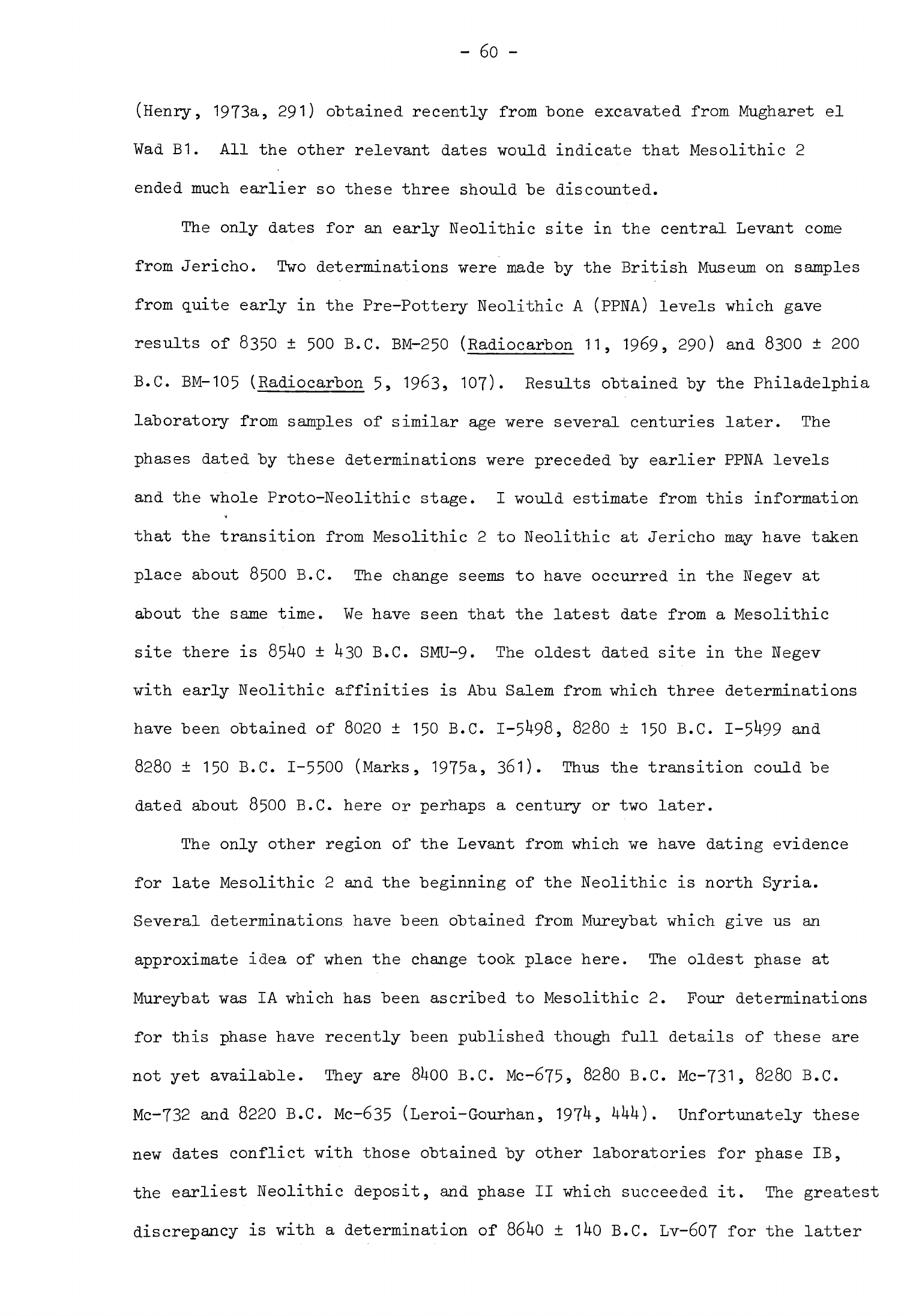
- 60
-
(Henry,
1973a,
291)
obtained
recently
from
bone
excavated
from
Mugharet
el
Wad
B1.
All
the
other
relevant
dates
-would
indicate
that
Mesolithic
2
ended
much
earlier
so
these three
should
be
discounted.
The
only
dates
for
an
early
Neolithic
site
in
the
central
Levant
come
from
Jericho.
Two
determinations
were
made
by
the
British
Museum
on
samples
from
quite
early
in
the
Pre-Pottery
Neolithic
A
(PPNA)
levels
which
gave
results
of
8350
+
500
B.C.
BM-250
(Radiocarbon
11,
1969,
290)
and
8300
±
200
B.C.
BM-105
(Radiocarbon
5,
1963,
107).
Results
obtained
by
the
Philadelphia
laboratory
from
samples
of
similar
age
were
several
centuries
later.
The
phases
dated
by
these
determinations
were
preceded by
earlier
PPNA
levels
and
the
whole
Proto-Neolithic
stage.
I
would
estimate
from
this
information
that
the
transition
from Mesolithic
2
to
Neolithic
at
Jericho
may
have
taken
place
about
8500
B.C.
The
change
seems
to
have
occurred
in
the
Negev
at
about
the
same
time.
We
have
seen that
the
latest
date
from
a
Mesolithic
site
there
is
85^0
±
U30
B.C.
SMU-9.
The
oldest
dated
site
in
the
Negev
with
early
Neolithic
affinities
is
Abu
Salem
from
which
three
determinations
have
been
obtained
of
8020
+
150
B.C.
1-5^98,
8280
±
150
B.C.
1-5^99
and
8280
±
150
B.C.
1-5500
(Marks,
1975a,
361).
Thus
the
transition
could
be
dated
about
8500
B.C.
here
or
perhaps
a
century
or
two
later.
The
only
other
region
of
the
Levant
from
which
we
have
dating
evidence
for
late
Mesolithic
2
and
the
beginning
of
the
Neolithic
is
north
Syria.
Several
determinations
have
been
obtained from
Mureybat
which
give
us an
approximate
idea
of
when
the
change
took
place
here.
The
oldest
phase
at
Mureybat
was
IA
which
has
been
ascribed
to
Mesolithic
2.
Four
determinations
for
this
phase
have
recently
been
published
though
full details
of
these
are
not
yet
available.
They
are
8UOO
B.C.
Mc-675,
8280
B.C.
Mc-731,
8280
B.C.
Mc-732 and
8220
B.C.
Mc-635
(Leroi-Gourhan,
197^,
MiU).
Unfortunately
these
new
dates
conflict
with
those
obtained
by
other
laboratories
for
phase
IB,
the
earliest
Neolithic
deposit,
and
phase
II
which
succeeded
it.
The
greatest
discrepancy
is
with
a
determination
of
86^0
+
1UO
B.C.
Lv-607
for
the
latter
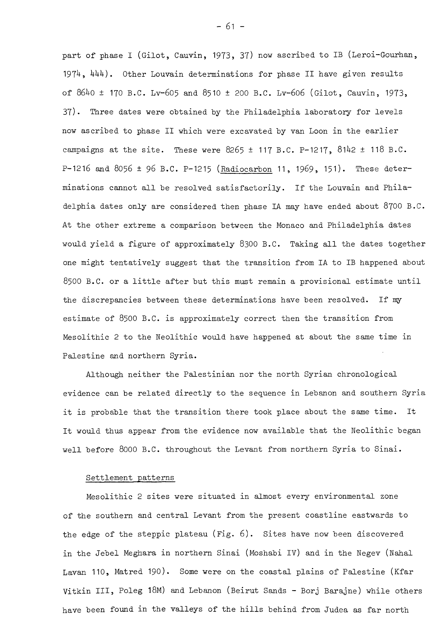
-
61
-
part
of
phase
I
(Gilot,
Cauvin,
1973,
37)
now
ascribed
to
IB
(Leroi-Gourhan,
197^,
^UU).
Other
Louvain
determinations
for
phase
II
have
given
results
of
86^0
±
170
B.C.
Lv-605
and
8510
±
200
B.C.
Lv-6o6
(Gilot,
Cauvin,
1973,
37)
Three
dates
were
obtained
"by
the
Philadelphia
laboratory
for
levels
now ascribed
to
phase
II
which
were
excavated
by
van
Loon
in
the
earlier
campaigns
at
the
site.
These
were
8265
±
117
B.C.
P-1217,
81>I2
±
118
B.C.
P-1216
and
8056
+
96
B.C.
P-1215
(Radiocarbon
11,
1969,
151).
These deter-
minations
cannot
all
be
resolved
satisfactorily. If the
Louvain
and
Phila-
delphia
dates
only
are
considered
then
phase
LA
may
have
ended
about
8700
B.C.
At
the
other
extreme
a
comparison
between
the
Monaco
and
Philadelphia
dates
would
yield
a
figure of
approximately
8300
B.C.
Taking
all
the dates
together
one
might
tentatively
suggest
that the
transition
from
IA to
IB
happened
about
8500
B.C.
or
a
little
after
but
this
must
remain
a
provisional
estimate
until
the
discrepancies
between
these
determinations
have
been
resolved.
If
my
estimate
of
8500
B.C.
is
approximately
correct
then
the
transition
from
Mesolithic
2
to
the
Neolithic
would
have
happened
at
about
the
same
time
in
Palestine
and
northern
Syria.
Although
neither
the
Palestinian
nor
the
north
Syrian
chronological
evidence
can
be
related
directly
to
the
sequence
in
Lebanon
and
southern
Syria
it
is
probable
that
the
transition
there
took
place
about
the
same
time.
It
It
would
thus
appear from
the
evidence
now
available
that
the
Neolithic
began
well
before
8000
B.C.
throughout
the
Levant
from
northern
Syria
to
Sinai.
Settlement
patterns
Mesolithic
2
sites
were
situated
in
almost
every
environmental
zone
of
the
southern
and central
Levant
from
the
present
coastline
eastwards
to
the
edge
of
the
steppic
plateau
(Fig.
6).
Sites
have
now been
discovered
in
the
Jebel
Meghara
in
northern
Sinai
(Moshabi
IV)
and
in
the
Negev
(Nahal
Lavan
110
9
Matred
190).
Some
were
on
the
coastal plains of
Palestine
(Kfar
Vitkin
III,
Poleg
18M)
and
Lebanon
(Beirut
Sands
-
Borj
Barajne)
while
others
have
been
found
in
the
valleys
of
the
hills
behind
from
Judea
as
far
north
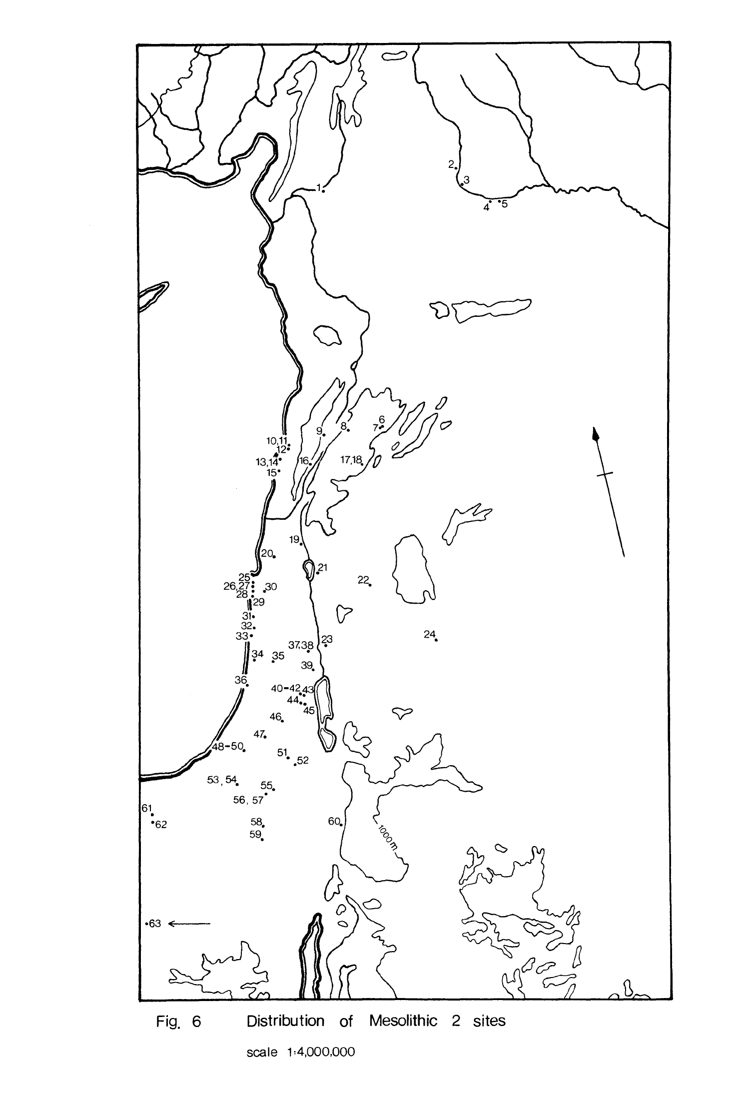
25
26,2
8
7|
.30
II
29
31.
32.
33'
3738
34 35
'
39
Fig.
6
Distribution
of
Mesolithic
2
sites
scale
1=4,000,000
FIGURE
6
Distribution
of
Mesolithic
2
sites
1
Tell
Dhahab
(Braidwood,
Braidwood,
I960,
476)
2
Nahr
el
Homr
(Roodenberg,
forthcoming)
3
Mureybat
(Cauvin,
1972,
107)
4
Dibsi
Faraj
East (Wilkinson,
Moore,
forthcoming)
5
Tell
Abu
Hureyra
(Moore,
1975,
56)
6
Yabrud
III
(Rust,
1950,
119)
7
Mugharet
el
Abde
(Nasrallah,
1951,
92ff)
8
Nacharini
9
Saaideh
(Schroeder,
1970,
200)
10
Jiita
II
(Chavaillon,
Hours,
1970,
230)
11
Jiita
III
(Copeland,
Wescombe,
1965,
92)
12
Antelias
(Copeland,
Wescombe,
1966,
162)
13
Beirut
Sands
-
Borj
Barajne
(Copeland,
Wescombe,
1965,
129)
14
Beirut
Sands
-
811
(Copeland,
Wescombe,
1965,
134)
15
Jiye
I
(Copeland,
Wescombe,
1965,
96)
16
Amiq
II
(Hours
et
al,
1973,
466)
17
Saidnaya
(van
Liere,
1961,
34)
18
Qornet Rharra
(de
Contenson,
1966a,
199)
19
Ain
Mallaha
(Perrot,
1966a)
20
Hayonim
(Bar-Yosef,
Goren,
1973)
21
En
Gev
IV
(Bar-Yosef,
1970a,
126)
22
Taibe
(M.-C.
Cauvin,
1974a)
23
Ala
Safat
(Waechter,
1948)
24
Azraq
25
Iraq
el
Barud
(Bar-Yosef,
1970a,
32)
26
Nahal
Oren
(Noy
et
al,
1973)
27
Abu
Usba
(stekelis,
Haas,
1952)
28
Mugharet
el
Wad
(Garrod,
Bate,
1937,
9)
29
Kebara
(Turville-Petre,
1932)
30
Rakafet
(Noy et
al,
1973,
96)
31
Caesarea
Sands
(Bar-Yosef,
1970a,
59)

32
Kefar
Vitkin
III
(Bar-Yosef,
1970a,
60)
33
Poleg
18M
(Bar-Yosef,
1970a,
72)
34
Gath
Rimon
(Bar-Yosef,
1970a,
81)
35
Shukbah
(Garrod,
1942)
36
Kefar
Darom
28
(Bar-Yosef,
1970a,
94)
37
Wadi
Fazael
IV
(Bar-Yosef
et
al,
1974,
423)
38
Wadi
Fazael
VI
(Bar-Yosef
et
al,
1974,
420)
39
Jericho
(Kenyon,
1970,
41)
40
Erq
el
Ahmar
(Neuville,
1951,
86)
41
Umm
Qalaa
(Bar-Yosef,
1970a,
175)
42
Ain
Sakhri
(Neuville,
1951,
133)
43
El
Khiam
(Perrot, 1951,
155)
44
Umm
ez-Zuweitina
(Neuville,
1951,
121)
45
Tor
Abu
Sif
(Neuville,
1951,
126)
46
P
508
(Bar-Yosef,
1970a,
145)
47
Beer
Faher
(Alon,
Noy,
1974)
48
Halutza
5
(Noy,
1970)
49
Halutza
82
(Burian,
Friedmann,
1973)
50
Halutza
83
(Burian,
Friedmann,
1973)
51
Tulmeh
(Bar-Yosef,
1970a,
145)
52
Kurnub
(Noy,
Schick,
1973)
53
Nahal
Lavan
IV
(Phillips,
Bar-Yosef,
1974a,
478)
54
Nahal Lavan
110
(Bar-Yosef
et_al,
1974)
55
Rosh
Zin
(Henry,
1973b)
56
Hatred
141 (Yizraeli, 1967)
57
Hatred
190
(Yizraeli,
1967)
58
Rosh
Horesha
(Harks
et
al,
1972,
80)
59
Arif
en-Naqa
(Bar-Yosef,
1970a,
149)
60
Beidha
(Kirkbride,
1966,
47)
61
Lagama
IX
(Phillips
et
al,
n.d.,
9)
62
Hoshabi
IV
(Phillips,
Bar-Yosef,
1974a,
478)
63
Helwan
(Hassoulard,
1949)
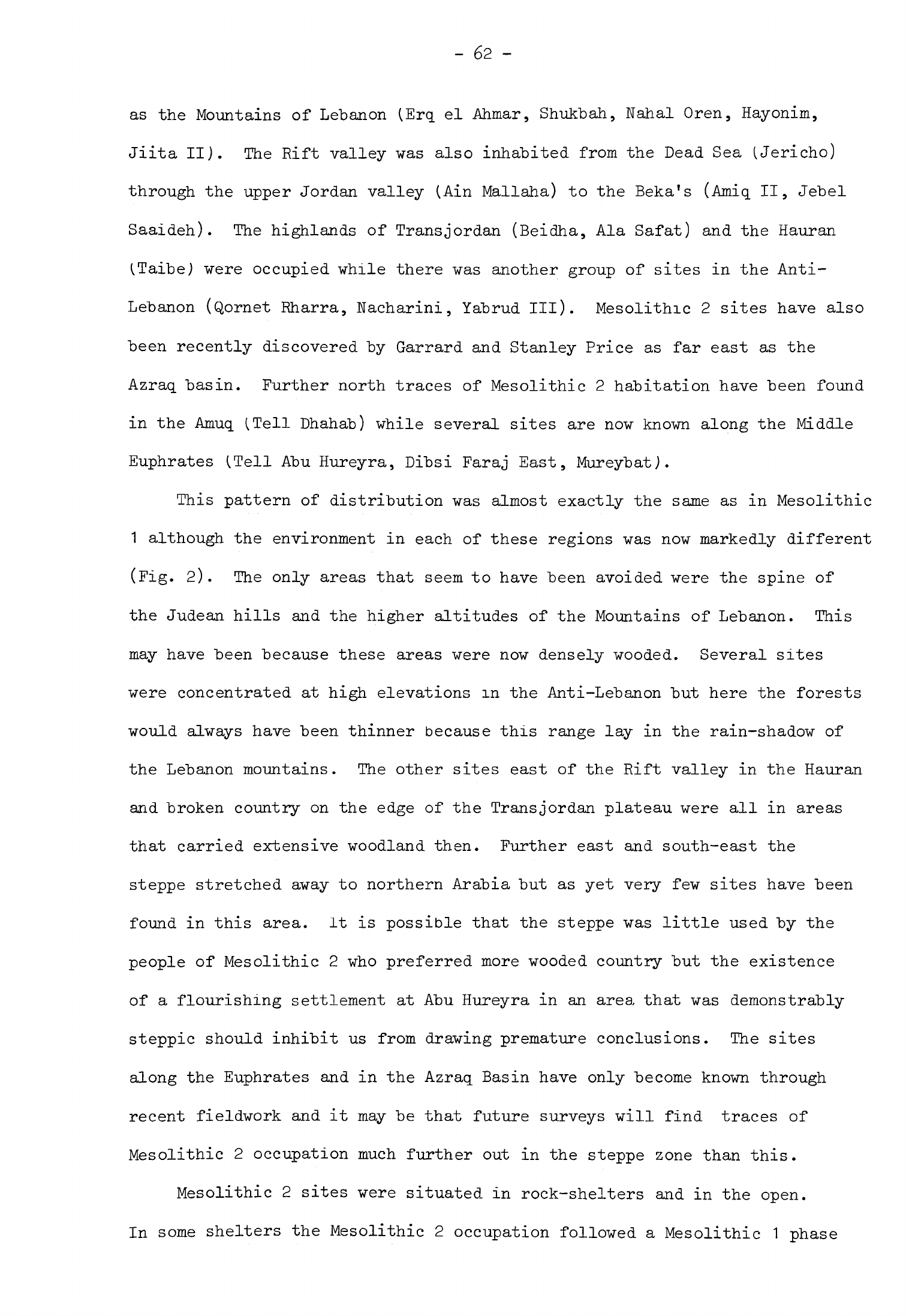
-
62
-
as
the
Mountains
of
Lebanon
(Erq.
el
Ahmar,
Shukbah,
Nahal
Oren,
Hayonim,
Jiita
II).
The
Rift
valley
was
also
inhabited
from
the
Dead
Sea
(Jericho)
through
the
upper
Jordan
valley
(Ain
Mallaha)
to
the
Beka's
(Amiq
II,
Jebel
Saaideh).
The
highlands
of
Transjordan
(Beidha,
Ala
Safat)
and
the
Hauran
(TaibeJ
were
occupied while
there was
another
group
of
sites
in
the
Anti-
Lebanon
(Qornet
Rharra,
Nacharini,
Yabrud
III).
Mesolithic
2
sites
have
also
been
recently
discovered
by
Garrard
and
Stanley Price
as
far
east
as
the
Azraq
basin.
Further
north
traces
of
Mesolithic
2
habitation
have
been
found
in
the
Amuq
(.Tell
Dhahab)
while
several
sites are
now
known
along
the
Middle
Euphrates
(Tell
Abu
Hureyra,
Dibsi
Faraj
East,
MureybatJ.
This
pattern
of
distribution
was almost
exactly
the
same
as
in
Mesolithic
1
although
the
environment
in
each
of
these
regions
was
now
markedly
different
(Fig.
2).
The
only
areas
that
seem
to
have been avoided
were
the
spine of
the
Judean
hills and
the
higher
altitudes
of
the
Mountains
of
Lebanon.
This
may
have
been because
these
areas
were
now
densely
wooded.
Several
sites
were
concentrated
at
high
elevations
in
the
Anti-Lebanon
but
here
the
forests
would
always
have
been
thinner
because
this
range lay
in
the
rain-shadow
of
the
Lebanon
mountains.
The
other
sites
east
of
the
Rift
valley
in
the
Hauran
and
broken
country
on
the
edge
of
the
Transjordan
plateau
were
all
in
areas
that
carried
extensive
woodland
then.
Further
east
and
south-east
the
steppe
stretched
away
to
northern
Arabia
but
as
yet
very
few
sites
have
been
found
in
this
area.
It
is
possible
that
the
steppe was
little
used
by
the
people
of
Mesolithic
2
who
preferred
more
wooded
country
but
the
existence
of
a
flourishing
settlement
at
Abu
Hureyra
in an
area,
that
was
demonstrably
steppic
should
inhibit
us
from
drawing
premature
conclusions.
The
sites
along
the
Euphrates
and
in
the
Azraq
Basin
have
only
become
known
through
recent
fieldwork
and
it
may
be
that
future
surveys
will
find
traces
of
Mesolithic
2
occupation
much
further
out in
the
steppe
zone
than
this.
Mesolithic
2
sites
were
situated
in
rock-shelters
and
in
the
open.
In
some
shelters
the
Mesolithic
2
occupation followed
a
Mesolithic
1
phase
-
63
-
as
at
Kebara
itself;
in
others
such
as
Erq
el
Ahmar
a
shelter
last
used
in
the
Aurignacian
was
re-occupied while
at
Umm
ez-Zuweitina
and
a
few
more
the
earliest
recorded
occupation
was
in
Mesolithic
2.
One
new
feature
of
shelter
sites
used
by
the
people
of
Mesolithic
2
was
that
the
area
of
concentrated occupation
was
frequently
on
the
terrace
in
front
rather
then
in
the
shelter
itself.
This
was
so
at
Mugharet
el
Wad,
Nahal
Oren,
Qornet
Rharra
and
probably
Hayonim.
Most
of
the
open
sites
had
only
Mesolithic
2
occupation
on
them
and
were
therefore
single-period
sites
as
were
almost
all
Mesolithic
1
open
stations.
A
few
such
as
Jericho
and
Beidha
were
covered
by
later
settlements.
Most of
the
larger
Mesolithic
2
sites
were
situated
in
the
foothills
of
the
upland
zones
near
permanent
sources
of
water.
Some
of
these
like
Hayonim,
Nahal
Oren,
Mugharet
el
Wad
and
Shukbah
were
in
wadis
and
others
such
as
Saaideh,
Jericho
and
Rosh
Zin
were
in
more
open
positions.
One
site
at
least,
Ain
Mallaha,
was
situated
beside
a
lake
but
also
on
the fringe
of
the
Galilee
hills.
There
seem
to
have
been
significantly
more
shelter
sites
in
Mesolithic
2
than
in
Mesolithic
1
which
may
reflect
the
apparent
concentration
of
Mesolithic
2
sites
around the
upland
zone.
Economy
and
society
Much
new
evidence
for
the
economy
of
Mesolithic
2
sites
is
now
available
which,
when
added
to what
was
known
from
earlier
excavations,
allows
us
to
suggest
in
outline
how
the
inhabitants
of
these
sites
lived.
Their
exploita-
tion of
animals
is
the
aspect
which
is
best
documented
from
the
numerous
collections
of
animal
bones
that
have
been
studied.
The
Natufians
in
much
of
Palestine
killed
many
more
gazelle
for
food than
any
other
animal.
The
per-
centage
of
gazelle
bones
to
all
others
at
Nahal
Oren
was
as
high
as
83.3%
(Noy
et
al.
,
1973»
90)
and
of
about
the
same
order
at
Mugharet
el
Wad
(.Garrod,
Bate,
1937»
1^1
9
fig.
1).
Several
other
species
found
on
these
sites
would
have been
eaten,
among
them
fallow
deer,
goat,
cattle and
pig.
The
proportion
-
6k
-
of
gazelle
"bones
was
also
high
at
Kebara,
the
third
large
Natufian
site
on
the
seaward
side
of
Mt.
Carmel,
and
at
Shukbah
(Bate,
1932,
277;
19^2,
19).
The
most
recent
study of
the
Kebaran
fauna
does
suggest,
however,
that
gazelle
formed
a
smaller
proportion
of
the
diet
than
in
Mesolithic
1
and
that
cattle,
pig
and
hartebeest
were
now
killed
in
some
numbers
(Saxon,
197^
9
fig.
3).
Moister
climatic conditions and the
spread
of
marshes
near
the
coast
may
have
led
to
an
increase
in
the
herds of these
animals
in
the
vicinity
of
Kebara.
Gazelle
bones
were
also
plentiful
at
Hayonim
(Bar-Yosef,
Tchernov,
1966,
129)
and
at
Ain
Mallaha
where
they
made
up
UU.6%
of
all
the
animal
bones
found
(Ducos,
1968,
73).
This
was
significantly
less
than
on
the
Carmel
sites
and
is
partly
explained
by
the
different
environments
of
these
two
settlements.
The
upper
Jordan
valley
would
have
been
well-wooded
and
marshy
in
Natufian
times,
rather
different
from
the
drier
hilly
hinterland
of
Mt.
Carmel
with
a
flat
coastal
strip
in
front
and
this
is
reflected
in
the
full
faunal
assemblage
from Ain
Mallaha.
Deer
were
much more
plentiful
here,
the
three
main
species
comprising
33.^-%
of
the animal bones.
Pigs,
which
would
have
been
abundant
around
Lake
Huleh,
were
quite common
('\h.2%]
while
cattle
and
caprines
were
present
in
small
quantities
only.
Gazelle
seems
to
have
been
an
important
source
of
meat
on
the
Negev
sites
of
Rosh
Zin
and
Rosh
Horesha
(Henry,
1973a,
128,
130).
Here
again
the
faunal remains
from
these
sites
reflect
their
environments
for
Capra
ibex
also
seems
to
have
been
plentiful
as
one
would
expect
in
this
drier,
broken
country.
Deer were
found
at
Rosh
Zin,
which
may
have
lived
in
the
Nahal
Zin
below
the
site,
and
equid
at
Rosh
Horesha,
possibly
reflecting
its
more
open position.
The
faunal
evidence
from
the
Judean
desert
sites
emphasises
that
hunting
patterns
were
significantly influenced
by
the
environment,
Neither
at
Erq
el
Ahmar
(Vaufrey,
1951
>
210)
nor
at
the
other
Natufian
sites
does
it
appear
that
gazelle
were
particularly
common,
presumably because
they
were
not
to
be
found
in
large
numbers
in
those
broken, wooded,
uplands.
A
number
of
other
species
-
65
-
better
adapted
to
such
conditions
-were
found
at
Erg
el
Ahmar
including
ibex,
roe
deer,
cattle
and
an
equid.
Gazelle
were
also
uncommon
in
the
Mesolithic
2
levels
at
Beidha
where
the
fauna
was
dominated
"by
goats
(Capra
hi
re
us
aegagrus
and
Capra
ibex
nubiana)
which
comprised
76.7%
of
the
bones
found.
These
species
would
have
been
particularly
plentiful
in
the
cliffs
and
hills
around
the
site.
As
on
other
sites
a
number
of
other
species
such
as
aurochs
and
an
equid
were
hunted
from
time
to
time.
The
archaeological
evidence
suggests that
the
Natufian
pattern
of
animal
exploitation
in
Palestine
was
strongly
influenced
by
what
species
were
readily
available
near
the
sites.
We
see
that
at
most
sites
one
species
was
much
preferred
to
all
the
others
and
this
was
the
animal
that
was
available
in
large
numbers near
the
site.
In
several
instances
this
was
the
gazelle
but
at
Beidha
it
was the
wild
goat;
a
number
of
species
were
readily
available
at
Ain
Mallaha
so,
although
more
gazelle
were
taken
here than
other
species,
the
proportion
was
not
so
marked.
Several
zoologists
have
examined
the
better-documented
faunal
collections
to
determine
at
what
age
these
species
were
killed
in
order
to
throw
more
light
on
methods
of
exploitation.
From
this
it
has
emerged
that
5^-.
1%
of
the
gazelle
at
Nahal
Oren
(Noy
et
al.
,
1973,
table
5)
and
75$
of
the
goats
at
Beidha
(Perkins,
1966,
67)
were
immature.
Although
the
Beidha
percentage
was
determined
on a
rather
small
sample,
it
is
especially
interesting
when
compared
with
the
figures
from
Wadi
Madamagh
where
only
23.1%
of
the
goats
were
immature.
These
results
would
seem
to
indicate
that
at
some
sites
care
was
exercised
to
kill
off
a
high
proportion
of
young
animals,
thus
following
a
pattern
of
exploitation
similar
to
that
of
domesticated
herds
(Bokonyi,
1969,
222).
This
pattern
was
not
a
universal
one
for
at
Ain
Mallaha
only
a
few
immature
gazelle
were
killed
(Ducos,
1968,
73ff).
This
evidence
suggests
that
the
people
of
Mesolithic
2,
like
their
ancestors
in
Mesolithic
1,
practised
selective
hunting.
There
was
a
slightly
- 66
-
greater
emphasis
on
a
particular
species,
usually
gazelle,
than
in
Mesolithic
1
which
indicates
that
by
now
this
form
of
exploitation
was
more
concentrated
or
intensified.
The
high
proportion
of
juveniles
killed
at a
few
sites,
while
it
may
suggest
a
mode
of
exploitation
akin
to
domesticated
herds,
cannot
really
be
regarded
as
the
same.
It
was
probably
a
particular
form
of
selective
hunting
rather
than
the
herding
hinted
at
by
Legge
(1972,
123).
Moreover,
although
the
evidence
is
still
very
uneven,
it
does
not
seem
to
have
been
a
very
common
practice.
While
intensive, selective
hunting
seems
to
have
been
practised
on
many
Mesolithic
2
sites,
this
was not
universally
so,
even
in
Palestine,
as
the
evidence
from
Ain
Mallaha
demonstrates.
No
statistical
information
is
available
for
the
fauna
of
the
Judean
desert
sites
but Vaufrey's
comments
do
not
indicate
that
the
Natufian
inhabitants there
exhibited
any
marked
preference
for
a
particular
species.
Even
at
Nahal
Oren,
although
gazelle
seem
to
have
formed
the
bulk
of
the
meat
diet,
the
weight
of
beef
consumed
was
considerably more than
the
percentage
of cattle
bones
present
(9.2$,
Noy
et
al.,
1973,
table
h)
would
imply and
this
was
also
the case
at
Kebara
(-Saxon,
197*+,
32).
It
is
important
to
remember
that
the
people
of
Mesolithic
2
were
prepared
to
kill
and
eat a
wide
range
of
other
game,
both
large
and
small,
which
would
have significantly
supplemented
their
diet.
Hares,
for
instance,
seem
to have
been
eaten
in
quantity
at
Hayonim
(Bar-
Yosef,
Tchernov,
1966,
126)
and
their
bones
were
found
at
Mugharet
el
Wad
(Garrod,
Bate,
1937, 152),
Beidha
(Perkins,
1966,
66)
and
other
Mesolithic
2
sites.
Both
terrestrial
and
marine
molluscs
were
eaten
at
Hayonim
(Bar-Yosef,
Tchernov,
1966,
135,
137)
and
Mugharet
el
Wad
(Garrod,
Bate,
1937,
22U)
,
shellfish,
turtles
and
fish
from
Lake
Huleh
at
Ain
Mallaha
(Perrot,
1966a,
U81).
Fish
were
also
consumed
at
Hayonim
(Bar-Yosef,
Tchernov,
1966,
133)
and,
on
the
evidence
of
the
fish-hooks,
probably
at
Kebara
(Turville-Petre,
1932,
272).
This
readiness
to
eat
a
wide
range
of
species
is
typical,
not
only
of
the
people
of
Mesolithic
2,
but
of
Mesolithic
1
and
earlier
hunter-
-
67
-
gatherers.
Although
there
were
differences
in
emphasis
between
the
hunting
practices
of the
Mesolithic
2
population
and
their
predecessors,
these
were
not
as
great
as
is
sometimes
supposed.
For
example,
it
has
"been
assumed
that
the
people
of
Mesolithic
2
were
the
first
to
eat
fish
and
other
aquatic
foods
and
that
these
formed
a
major
part
of
their
diet
(Binford,
1968,
33^).
In fact
the
evidence,
slight
though
it
is,
would
suggest
that
these
foods
were
used
at
some
sites
only
as
a
supplement
to
the
diet
and
that
this
had
"been
a
feature
of
the
economy
of
Levantine
sites
at
least since
the
Aurignacian.
There
is
no
evidence available
yet
for
exploitation
of
animals
from
Mesolithic
2
sites
in
Lebanon
and only
preliminary
information
from
the
Euphrates
valley
settlements.
We
know
that
gazelle,
onager,
cattle,
sheep/
goat,
hares,
fish
and
shellfish
were exploited
at
Abu
Hureyra
and
Mureybat
and,
although
detailed
figures
are
not
available, that
the
gazelle
and
onagers
were
killed
in
some
quantity.
This
suggests
that
selective
hunting
was
also
being
practised
at
these
two
sites
and
that
the
species
preferred
were
those
herbivores
which
were
especially
numerous
in
the
neighbourhood.
This
mode
of
hunting
would
seem
to
have
resembled
Natufian
practices
in
Palestine,
so
far
as
one
can
see
at
the
moment.
Both
direct
and
indirect
evidence
has
been
found
for
the
consumption
of
plant
foods
in
Mesolithic
2.
The
remains
of
the
plants
themselves
recovered
from archaeological
deposits
provide
direct
evidence
while
artifacts,
structural
features,
human
remains
and
the
setting
of
sites
are
all
sources
of
indirect
evidence.
Plant
remains
are
much
the
easiest
evidence
to
inter-
pret
but
they
have
been
recovered
fron only
one
site
so
far
in the
Natufian
heartland,
Nahal
Oren;
even
then
no
more
than
25
seeds
were
found
(Noy
et
al.,
1973,
table
6).
The
identified
seeds
at
Nahal
Oren
were from
vetches,
grasses
and
vines,
all
of
which
could
have
been used
for
food.
Conditions
for
seed
survival
at
Nahal
Oren seem
to
have
been
unfavourable
as
so
few
were
recovered.
Since
cereal
grains
were
found
in
the
Kebaran
and
Neolithic
levels
at
the
site
-
68
-
they
may
have
"been
eaten
in
the
Natufian,
although none
were
retrieved
from
those
layers.
Very
many
more
seeds
and
charcoal have
been
found
in
the
Mesolithic
levels
at
Abu
Hureyra
and
some
plant
remains
at
Mureybat.
One
can
describe
the
exploitation
of
plants
in
the
Middle
Euphrates
in
more
detail
from
this
evidence
but
one
cannot
apply
many
of
the
conclusions
to
Mesolithic
2
sites
elsewhere
in
the
Levant.
Not
all
the
samples
of
plant
remains
from
the
Mesolithic
levels
at
Abu
Hureyra
have
been
examined
yet
but
already
the
plant
economy
of
the
site
can
be
discerned
in
outline
(detailed
account
in
Hillman,
1975j
TOff).
Cereal
grains,
particularly
of
wild-type
einkorn,
were
quite
common
in
all
the
samples
studied
so
far.
Grains
of
both
wild-type and
domesticated
barley
and
rye
were
also
present,
all
in
well-stratified
deposits.
Grains of
domesticated
barley
have
not
been
found
in
such
an
early
context
before
so
we
cannot
discount
the
possibility
that
they
may
have
filtered
down
through
rodent
burrows
into
the
Mesolithic
levels
from
the
Neolithic
settlement
above.
The
rye
probably
grew
with
the
other
cereals.
The
presence
of
all
these
cereals
at
Abu
Hureyra
would
suggest
that
they
were
being
eaten
in
some
quantity
there.
This
was
probably
also
the
case
at
Mureybat
where wild-type
einkorn
has also
been
found
in
the
Mesolithic
3
2
layers.
Were
these
cereals
growing
in
the
vicinity
of
these
sites
during
Mesolithic
2
and,
if
so,
were
they
collected
from
the
wild
or
deliberately
planted
and
harvested?
The
answers
to
these
questions
depend upon
the
botanical
status
of
these
plants
and
the
prevailing
climate
at
the
time
the
sites
were
occupied.
More
grains
of
wild-type
einkorn
have
been
identified
than
of
the
other
cereals
at
Abu
Hureyra
so
the
origin
of
these
seeds
may
be
considered
in
some
detail.
Hillman
believes
that
there
were
three
possible
ways
in
which
the
einkorn
could
have
been
obtained.
If
the
einkorn was
growing
near
the
site
then
it
could
have
been
harvested
from
these
wild
stands.
Wild
einkorn
cannot
grow there
today
because
the
area
is
too
arid.
The
climate
would
have
been
both
cooler
and
moister
in
Mesolithic
i

-
69
-
so
conditions
would
have
been
more favourable
for
the
wild
plant
to
have
grown there
then.
The
second
possibility
is
that
the
einkorn
was
gathered
from
natural
stands
growing
in a
more
favourable environment among
the
foothills
of
the
Anti-Taurus
as
much
as
200
km
to
the
north.
This
suggestion
was
first
made
by
van Zeist
to
explain
the
presence
of
wild-type
einkorn
in
late
9th and
early
8th
millennia
B.C.
deposits
at
Mureybat
(1970,
172).
The
Mesolithic
settlement
at
Abu
Hureyra
was
quite
substantial
and was
occupied
for
a
relatively
long
period.
It
would
be
difficult
to
understand
how
its
inhabitants
could
have
supported
themselves
if
a
significant
amount
of
their
food
had
to
be
imported
since
the
means
for
transporting
large
quantities
of
grain
over such
a
distance
did not
then
exist.
For
these
reasons
this
seems
to
be the least
likely
explanation.
The
third
possibility
is
that
wild-type
einkorn
was already
being
cultivated around
Abu
Hureyra
but
had
not yet
undergone
the
selection
process
which
led
to
the
development
of
a
morphologically
"domesticated"
form.
The
environment
was
probably
sufficiently
favourable
for
einkorn
to
have
grown
wild
or
to
have
been
cultivated
so
either
would
have
been
possible from
what
we
know
about
the
status
of
the
plant
and
the
contemporary
climate.
Hillman
has
now
found
further
evidence
which
indicates
which
explanation
should
be
preferred.
Among
the cereal
grains
were
many
other
seeds
of
plants
which
flourish
in
disturbed
ground.
This
suggests
that
the
soil
in
the
vicinity
of
Abu
Hureyra
was
already
being
broken
for
cultivation
and
that,
therefore,
the
einkorn
was
already
being
deliberately
planted
and
harvested
as
a
crop.
The
evidence
is
not
yet
conclusive
but
we
may
reasonably
hope
that
this
explanation
will
be
corroborated
when
all
the
plant
remains
have
been
studied.
Other
food
plants
have
been
identified
among
the
plant
remains.
The
most
abundant
was
a
common
vetch,
probably
Vicia
sativa^
but
bitter
vetch,
Vicia
ervilia,
and
wild-type
lentils
were
also
present.
The
common
vetch
in
particular
would
have
been
an
important
constituent
of
the
diet.
Fruits
and
nuts
from
a
number
of
other
species
were
also
collected
and
eaten,
among
-
TO
-
them
caper,
hackberry
and
turpentine.
Not only
were
considerable
amounts
of
cereals
and vetches
consumed
"but
also
a
variety
of
other
vegetable
foods
in
season.
Although
plant
remains
are
much
the
most
satisfactory
evidence
for
the
use
of
vegetable
foods
they
have
been
found
on
very
few
Mesolithic
2
sites
so
far.
Certain
categories
of
indirect
evidence,
on
the
other
hand,
are
common
to
most
of
these
sites.
Sickle
blades and
grinding
tools
have
been
found
on
most
Natufian
sites
in
Palestine
and
on
many
Mesolithic
2
sites
in
Lebanon
and
Syria.
These
artifacts
are
frequently
thought
to
have
been
used
for
harvesting
and
preparing
plant
foods
(Henry,
19T3a,
190).
While
this
may
have
been
the
case,
it
has not
yet
been
conclusively
demonstrated.
As
I
have
already
explained
both
classes
of
tools
could have
been
used
for
purposes
other
than food
processing.
Almost
all the
grinding
tools
found
at
Abu
Hureyra
were
stained
with
red
ochre
as
if
they
had
been
used
for
grinding
the
pigment.
Many
of
the
grinding
tools
from
Mugharet
el
Wad
(Garrod,
Bate,
1937,
Ul),
Ain
Mallaha
(Lechevallier,
Valla,
197^,
193)
and
other
Mesolithic
2
sites
were
also
stained
with
ochre
so
these
tools
are
not
unequivocal
evidence
for the
use
of
plant
foods
in
Mesolithic
2.
It
should
be noted,
however,
that
many
more
of
these
tools
have
been
found
on
Mesolithic
2
than
on
Mesolithic
1
sites.
Whatever
tasks
they
were used
for
were
performed
more
frequently
than before.
h
The
idea
has
been
put
forward
that
the
people
of
Mesolithic
2
used
acorns
for
food.
Acorns
are
quite
nutritious
(Renfrew,
1973,
19^-)
and may
be
harvested
in
considerable
quantities
in
the
autumn.
They
have
to
be
processed
before
they
can
be
eaten since
they
contain
bitter
tannin.
Once
these
have
been
removed
the
acorns
may
be
baked
as
cakes
or
bread
or
used
in
other
ways.
There
is
evidence
that
acorns
were
used
by
various
peoples
in
the
past
since
their
remains
have
been
found
on
many archaeological
sites
(Renfrew,
1973,
15^-).
They
were
also
eaten
in
considerable
quantities
by
Californian
Indians
until quite
recently
(Gifford,
1936,
87ff).
A
peasant
-
71
-
from
a
village
in
the
Jebel
Barisha
in
north-west
Syria told
me
in
1977
that
acorns
were
still
eaten
by
the
poor
there
in
years
when
the
harvest
failed.
He
himself
was fully
conversant
with
methods
of
preparing
acorns
for
food.
Remains of
acorns
have
not
been
found
on
Mesolithic
2
sites
but
there
is
some
other
evidence
supporting
the
idea
that
they
may
have
been
eaten.
Oak
trees
were
an
important
constituent
of
the
Mediterranean
forest
which
was
more
extensive during
Mesolithic
2
than
in
any
later
period.
Most
of
the
larger
Mesolithic
2
sites
and
many
of
the others
were situated
in
this
zone.
Cereal
grasses
would
not
have
grown
so
prolifically
in
the
Mediterranean
forest
as
in
the
more open
country
of
the
intermediate
forest
and
steppe
so
this
source
of
food
would
not
have
been
particularly
abundant.
Acorns,
on
the
other
hand,
would
have
been
available
in
great
quantities
and
could
have
been
a
useful
supplement
or
even
a
staple
of
the
diet.
One
method
of
pre-
paring
acorns
for
food
involves
crushing
the
kernels
to
a
paste
in
a
mortar.
It
may
be
more
than
a
coincidence,
therefore,
that
large
mortars
and
pestles,
often
showing
considerable
signs
of
wear,
which
could
have
been
used
for
crushing
acorns
have
been
found
on
many
of
the
large
sites
in
or
on
the
fringe
of
the
Mediterranean
forest
zone
such
as
Mugharet
el
Wad,
Nahal
Oren,
Jericho,
Ain Mallaha
and
Jebel
Saaideh.
They
have
not
been
found
at
Abu
Hureyra,
Mureybat
nor
on
sites
in
other
steppic
areas
where
oaks
could
not
have
grown
during Mesolithic
2.
If
acorns
were
eaten
in
some
quantity
in
Mesolithic
2
then
it
is
probable
that
they
continued
to
be
consumed
during
the
Mesolithic.
One
other
modest
piece
of
evidence
suggesting
the use
of
plants
was
found
at
Ain
Mallaha.
A
number
of
plaster-lined
pits
were
excavated
there
and
these
were
interpreted
as
storage
containers
for
vegetable
foods
(Perrot,
1966a,
460).
The
pits
may
well
have
been
used
for
this
purpose
although
there
are
other
possible
interpretations.
Storage
facilities
would
be
needed
by
communities
using
large
quantities
of
plant
foods
and
inhabiting
-
72
-
extensive
settlements
like
Ain
Mallaha
for
more
than
one
season
of the
year.
This
is
the
earliest
record
from
a
Levantine
site of
features
possibly used
for
storage.
Large
pits
have
been
found
at
Nahal
Oren
(Stekelis,
Yizraely,
1963,
11)
but
at
no
other
Mesolithic
2
site;
The
only
other
contemporary
settlement
with
large
pits
was
Abu
Hureyra
but
here they
almost
certainly
served
a
different
purpose.
If
the
pits
at
Ain
Mallaha
and
Nahal
Oren
were
for
storing
food
they
were
uncommon
elsewhere.
Skeletons
from
Ain
Mallaha
and
Mugharet
el
¥ad
have
furnished
rather
better
evidence
for
the
use
of
plant
foods
in
Mesolithic
2..
A
recent
study
of the
teeth
of
these
skeletons
has
shown
that they
were
very
worn,
like
thos
of
burials
from
later
Neolithic
sites
(P.
Smith,
1972,
237).
This
was almost
certainly
caused
by
eating
coarsely-ground
cereals.
Interestingly
enough,
Smith
found
that
the
teeth
of
Natufian
skeletons
from
Kebara
were
much
less
worn
as
though
the
inhabitants
had
eaten
only
relatively
soft
foods
such
as
meat
and
unground
plants.
If
we
examine
the siting
of
Mesolithic
2
settlements
this
gives
us
some
information
about
the
potential
suitability
of
the
environment
of
these
sites
for
hunting,
gathering
or
simple
farming.
A
large
number
of
Mesolithic
2
shelter
sites
were situated
in
wadis
on
the
fringes
of
or
actually
in
the
upland
zone
of
the
Anti-Lebanon,
on
the
western
side
of
the
Mountains
of
Lebanon,
Galilee,
Carmel
and
Judea,
in
the
Judean
desert,
the
Negev
and
in
TransJordan.
They
were
surrounded
by
woodland
with
abundant
vegetable
resources
and
a
good
water
supply
near
more
open
country,
often
with
good
hunting
potential.
As
Henry
has
noted
(1973a,
188)
they
were
also
in
the
presumed
habitat
of
wild
cereals.
All
these
sites
were
well
placed
for
intensive
hunting
and
gathering
but
their
catchments
included
very
little
potential
arable
land
(Vita-Finzi, Higgs,
1970,
16)
so
it
is
unlikely
that
their
inhabitants
practised
any
form
of
agriculture.
Other
Mesolithic
2
sites
were situated
in
more
open
country.
The
catchments
of
a
number
of
these,
Saaideh,
Ain
Mallaha,
Rakafet
(Vita-Finzi,
-
73
-
Higgs,
1970,
21
)
and
Qornet
Rharra
included
much
potential
arable
land
so
that
it
would
have
been possible
for
the
inhabitants
to
have
planted
crops
nearby.
This
also
applies
to
the
four
Euphrates
sites,
all
of
which
had
abundant
potential
arable
land
in
their
catchments,
much
of
it
with
light
soil
particularly
suitable
for
simple
agricultural
techniques.
In
contrast,
very
few
Mesolithic
1
sites
had
a
catchment
area
with
significant
quantities
of
potential
arable
land.
It
is
also
significant
that
Mesolithic
2
occupation
has
now
been
found
at
the
bottom
of
four
tell
sites
with
later
substantial
Neolithic
settlements
which
depended
on
agriculture,
Jericho,
Beidha,
Abu
Hureyra
and
Mureybat,
yet
no Mesolithic
1
occupation
has
been
found
at
the
foot
of
any
agricultural
tell
settlement.
Because
the
Levant
is
a
region
of
great
geographical
variation
a
number
of
Mesolithic
2
sites
only
a
few
kilometres
apart
from
each
other
were
situated
in
contrasting
environmental
zones.
Thus
their
catchments
offered
complementary
resources
with
marked
seasonal
differences.
One
such
area
with
several
Natufian
sites
close
together
was
Mt.
Carmel.
Vita-Finzi
and
Higgs
have
suggested
(1970,
22ff)
that
the
inhabitants
of
sites
such
as
Nahal
Oren,
Mugharet
el
Wad
and
Kebara
at
the
foot
of
the
Carmel
range
may
have
moved
into
the
uplands
behind
at
certain
seasons
in
order
to
exploit
the
resources
of
the
area
more
fully.
Such
a
pattern
of
transhumance
might
have
led
these
groups to
spend
the
early
summer
in
the
hills
harvesting
cereals
and
hunting
or
herding
animals
on
the
upland
pastures.
In
the
dry
late
summer
they
and
the
animals
would
have
descended
to
the
coastal
plain
to
live
near
permanent
sources
of
water
available
near
the
sea and
stayed
on
through
the
winter
while
the
animals
grazed
on
the
lush
lowland
pastures.
Excavation
has
since
confirmed
(Noy,
Higgs,
1971,
225)
that
the
upland
site
of
Rakafet
had
a
long
sequence
of
Mesolithic
occupation
and
so it
could
have
been
a
comple-
mentary
site
to
Nahal
Oren
for
transhumance
in
Mesolithic
2
as
well
as
in
Mesolithic
1
(Noy
et
al.,
1973,
95ff).
The
principal
advantage
of
transhumance
was
that
it
permitted
more
people
to
live
off
the
resources
of the
region
than
would
otherwise
have
"been
possible.
Lowland
and
upland
sites
would
have
offered
an
abundance
of
plant
and
animal
foods
at
different
seasons.
Human
groups
could
move
between
them
at
the
most
favourable
time,
probably
in
early
summer
and
autumn.
Thus
the
group
could be
larger
than
would
be
possible
if
it
remained
in
the
vicinity
of
a
single
lowland
or
upland
site.
This
pattern
of
vertical
movement
was
also
advantageous
when
the
presence
of
other
groups
in
neigh-
bouring
territories
made
it
impossible
for the
inhabitants
of
a
site to
split
up
and
spread
out
across
the
landscape
in
the
lean
season.
Transhumance
may
well
have
been
practised
by
Mesolithic
2
groups
else-
where
in
the
Levant
where
different
environments
were
to
be
found
only
a
few
kilometres
apart.
One
such
area
might
have
been
the
Judean
hills
with
the
lowland
zones
of
the
coastal
plain
and
the
Jordan
valley
on
either
side.
Another
might
have
been
the
hills
of
Galilee
with
the
Plain
of
Esdraelon
below
while
a
third
might
have
been
the
seaward
slope
of
the
Lebanon
Mountains
where
there
was
a
great
environmental
contrast
between
the
coastal
plain
and
the
upland
pastures
in
the
mountains
behind.
Transhumance
is
less
likely
to
have
been
practised
east
of
the
Rift
valley
and
in
the
semi-arid
zone
because
here
there
was
insufficient
contrast
for
neighbouring
zones
to
have
offered
complementary
resources.
To
summarise,
the
people
of
Mesolithic
2
practised
selective
hunting
of
specific
species,
at
some
sites
killing
a
high
proportion
of
immature
animals.
At
each site
this
hunting
pattern
was
strongly
influenced
by
the
local
environment.
They
also
took
a
great
variety
of other species
for
food.
This
pattern
had
much
in
common
with
the
Mesolithic
1
economy
but
was
clearly
a
more
intensive
and
refined
version
of
it.
Plant
foods
were
very
important
in
the
diet;
the
fruits,
seeds
and
other
parts
of
many
different
plants
were
eaten
but,
on
the
Euphrates
sites
at
least,
cereals
seem
to have
been
the
main
source
of
food.
This
may
have
been
so
in
earlier
times
but
it
is
only
now
that
we
find
clear
evidence
of
-
75
-
the
importance
of
cereals
in
the
diet.
There
seems
little
doubt
that
on
most
sites
these
plants
-were
gathered
from
the
wild
as
in
the
past.
A
few
sites
were
situated
in
areas
with
land
suitable
for
cultivation
nearby
and
it
is
possible
that
on
these
sites
cereals
and vetches
were
being
cultivated
for
the
first
time.
Mesolithic
2
sites
may
be
divided
into
three
groups
according
to
size.
The
smallest
sites
were
all
under
100
sq
m
in
area.
This
group
included
several
shelter
sites
of
which
Yabrud
III
with
a
probable
maximum
area
of
50
sq.
m
was
typical
(Rust,
1950,
100,
pi.
96)
and
a
number
of
open
stations.
There
were
some of
these
on
the
coastal
plain
of
Palestine
such
as
Kfar
Vitkin
III,
Caesarea
sands
and
Kefar
Darom
28
on
which
a
few
Mesolithic
2
flints
have
been
found
(Stekelis,
1968,
333;
Bar-Yosef,
19TOa,
59, 9*0
together
with
earlier
material.
Others
like
Nahal
Lavan
IV
(20
sq
m)
were
in
the
Negev
(Phillips,
Bar-Yosef,
197^a,
^78).
The next group
of
sites
was
those
of
medium
size
between
100
and
500
sq
m.
Erq
el
Ahmar
(165
sq
mj
,
Kebara
(300
sq
m),
Jiita
II
(about
350
sq
m
in
Mesolithic
2
)
and
Mugharet
el
Wad
(^75
sq
m
taking
terrace
and
cave
occupation
together,
Garrod,
Bate,
1937
9
pi.
Ill)
were
all
in
this
group.
Moshabi
IV
(200
sq
m)
in
Sinai
was also
of
medium
size
(Phillips,
Bar-Yosef,
197^a,
U78).
It
is
probable
that
Abu
Hureyra
and Dibsi
Faraj
East
(Wilkinson,
Moore,
forthcoming)
were
about
this
size.
These
sites
were
of
the
same
area
or
a
little
larger
than
Mesolithic
1
composite
band
sites.
The
large
sites
which
could
be
from
000
up
to
2000
sq
m
in
area
formed
the
third
group.
Shukbah
(800
sq
m)
and
Rosh
Zin
(900
sq
m)
(Garrod,
19^2,
3;
Henry,
1973b,
129),
were
two
of
the
smaller
sites
in
this
group;
Hayonim
where
the area of the
terrace
and
shelter
was
somewhat
more
than
1000
sq
m
(Bar-Yosef,
Goren,
1973,
^9)
came
in
the
middle.
Wadi
Fazael
IV
(1000-1500
sq
m,
Bar-Yosef
et
al.
,
197^-
9
423J
was
about
the
same
size
as
Hayonim.
Ain
Mallaha
was
at
least
2000
sq
m
in
area
IPerrot,
1966a,
U37)
and
so
one
of
the
largest
known
Mesolithic
2
sites.
There
is
one
other
site,
Rosh Horesha,
-
76
-
which
was
much
larger
even
than
this.
The
site
is
now
about
7000
sq
m;
the
original area
of
occupation
was
somewhat
smaller
(Henry,
1973&,
129)
but
it
was
still
far
bigger
than
any
other
known
Mesolithic
2
site.
Rosh
Horesha
was
discovered
quite
recently
and
it
is
not
yet
clear
if
in
fact
it
was
a
single
phase
site
or if
several
phases
of
occupation
were
represented
there. The
terrace
at
El
Khiam
was
about
7500
sq
m
in
area
(Perrot,
1951,
fig.
59)
and
it
is
possible
that
the
Mesolithic
2
site
covered
much
of
it.
If
so,
it
would
have
been
another exceptionally
large
site
but
this
cannot
now
be
determined
with
certainty.
Most
Mesolithic
2
sites
fall
into
the
small and
medium
groups
and
were
thus
similar
in
size
to
Mesolithic
1
and
Aurignacian
sites.
Only
a
few
activities
were
carried
out
on
the
small
sites
and
their
occupation
was
short-lived.
This
is
reflected
in
the
small
number
of
artifact
types
found
on
these
transitory
stations:
flints
and
a
few
bone
tools
at
Abu
Usba
(Stekelis,
Haas,
1952,
21)
and
Yabrud
III
(Rust,
1950,
119),
flints
only
at
Tulmeh
and
Poleg
18M
(Bar-Yosef,
I970a,
72ff,
1U5)
and
very
few
flints
even
at
Ala
Safat
(Waechter,
19^-8,
101ff).
These
sites
were
hunting
stations
that
were used
intermittently
by
families
or
other
small
groups.
Greater
artifact
variability
on
the
medium-sized
sites
indicates
that
a
wider
range
of
activities
was
practised
on
them.
Erq
el
Ahmar,
Kebara
and
Mugharet
el
Wad
all
had
numerous
flint,
bone
and
ground
stone
artifacts
and
decorative
objects.
These
sites
were
probably
used
by
communities
of
composite
band
size
principally
engaged
in
hunting
and
gathering,
as
their
ancestors
had
been
in
Mesolithic
1
and
the
Aurignacian.
Tne
big
Mesolithic
2
sites
found
in
the
southern
Levant
were
a
significant
new
group.
They
appear
to
have been
inhabited
by
larger
communities
of
people than
before.
Furthermore,
the
occupation
of
these
sites
was
more
intensive
and longer-term:
the
numerous
species
of
mollusca
and
human
commensals
found
in
the
Natufian
layers
at
Hayonim
are
evidence
for
this
(Bar-Yosef,
Tchernov,
1966,
135,
138).
The
archaeological
deposits
-
77
-
themselves
were
usually
thicker
than
in
Mesolithic
1
,
a
maximum
of
3m
at
Mugharet
el
Wad,
3.5
m
at
Shukbah
(Garrod,
Bate,
1937,
9;
Garrod,
1942,
2)
and
3
m
at
Ain
Mallaha
(Perrot,
1966a,
U39),
composed
mostly
of
occupation
debris
with
relatively
little
erosional
deposit.
Many
pestles,
rubbers,
mortars
and
other
ground
stone
tools
have
been
found
on
large
as
-well
as
medium
Mesolithic
2
sites, far
more than
in
Mesolithic
1.
These
implements
took
a
long
time
to
make and
vere
too
heavy
to
carry
far
so
they
are
another
indicator
of
long-term
occupation.
A
recent study
of
the
numerous
human
remains
from
Hayonim
has
shown
that
they
probably
all
belonged
to
the
same
family
(Smith,
1973,
70).
These
individuals
were
buried
at
intervals
throughout
the
period
in
which
the
Natufian
deposit
accumulated,
indicating
long-term
use
of
the
site
by
at
least
one
family.
These
large
settlements
were
unknown
before Mesolithic
2.
Some change
had
taken
place,
therefore,
creating
conditions
which
favoured
the
establishment
of
these
new
sites.
Occupation
on
most
of
the
small
and
medium
sites
was
still
transient
or
seasonal
but
on
some
of
the
medium
sites
it
was
now
repeated
quite
often
and
so
was
more
intensive
than
before.
Occupation
on
the
new
large
sites
was
both
long-term
and
intensive.
This
could
mean
either
that
these
sites
were
visited
regularly
and
repeatedly
or
that
they
were
occupied
all the
year
round
for
a
period
of years. As
the
groups
that
inhabited
these
sites
were
more numerous than
any
known
before,
they
needed
a
larger
guaranteed
regular
food
supply. This
and
more
regular
occupation
of
the
sites
of
medium
size
explains
why
the
pattern
of
hunting
was
more
intensive. There
would
have
been
more
pressure
on
plant
resources
too,
reflected
in
more
intensive
collecting.
The
need
for
a
larger
guaranteed
supply
of
plant
as
well
as
animal foods
would
have
provided
the
incentive
to
begin
cultivation,
once
the
demand
exceeded
the
supply
available
from
the
wild.
Although
much
of
the
demand
could
still
be satisfied
from
wild
resources
I
think
it
is
likely
now
that
some
form
of
cultivation
was
undertaken
for
the
first
time
on
those
sites
situated
in
the most
favourable
areas.
As
occupation
of
many
sites
-
78
-
was
now
more
long-term,
storage
facilities
would
have
"been
needed
to
keep
food
harvested
in
one
season
until
it
was
consumed
later
on,
whether
it
was
gathered
from
the
wild
or
from
cultivated
plots;
there
is
some
archaeological
evidence
of
possible
storage
facilities
at
two
sites,
as
we have
already
noted,
and
perishable
containers
of
wood
or
basketry
may
have
been used
on
others.
One
advantage
of
cereals
over
other
plant
foods
is
that
they
can
quite
easily
be stored
for
many
months
without
decaying.
We
must
now
ask
what
brought
about
these
changes
in
settlement
and
economy
that
we
have
noted
in
the
archaeological
record?
One
possible
explana-
tion
is
that
there
was
an
expansion
of
population
at
the
end of
Mesolithic
1.
The
idea
that
population
growth might
be
a
cause
of
economic
and social
change
in
primitive
societies
has
been
much
discussed
by
anthropologists
and
others
in
recent
years.
An
important
theoretical
contribution
was
made
by
an
economist,
Boserup,
in
1965.
She
wished
to
explain
agricultural
change
in
the
recent
past
and
concluded
that
growth
or
decline
in
population
was
an
independent
variable
that
determined
pressure
on
the
food
supply.
Under
conditions
of
sustained
population
growth
this
pressure
would
lead
to
pro-
gressively
more intensive
methods
of
food
production
(19^5,
15ff).
She
also
believed
that
population
pressure
had
caused
the
earliest
experiments
in
agriculture
(1965»
53).
Her
views
are
helpful,
therefore,
when
trying
to
understand
the
beginnings
of
agriculture
in
the
Levant.
A
few
years
later
Binford
came
to
the
same
conclusion
independently
(1968,
332ff),
when
he
examined
world-wide
changes
in
subsistence
patterns
at
the
end
of
the
Pleistocene.
He
argued
that
man
came
to
depend
on
seasonal
food
resources,
particularly
aquatic
foods,
at
the
beginning
of
the
Holocene
and
that
this
was
accompanied
by
increased
sedentism.
As
communities
became
more
sedentary
so
the
population
grew,
pressing
upon
the
available
food
supply;
agriculture
was then
developed
as
a
response
to
this
pressure.
Several
of
Binford
1
s
premises
seem
improbable
when
applied
to the
Levant;
man
was
partly
dependent
upon
seasonal
food
resources,
for
example,
as
far
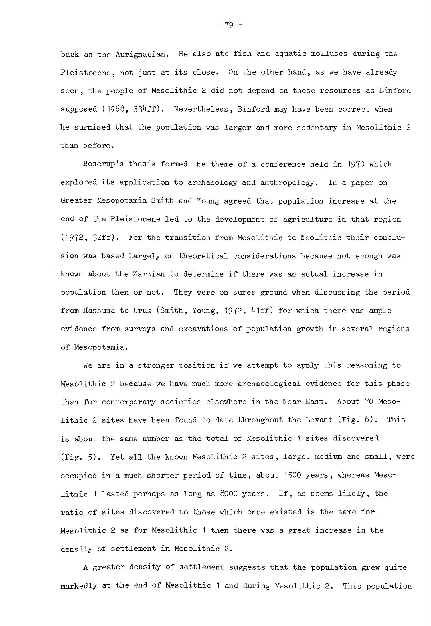
-
79
-
back
as
the
Aurignacian.
He
also
ate
fish
and
aquatic
molluscs
during
the
Pleistocene,
not
just
at
its
close.
On
the
other
hand,
as
we
have
already
seen,
the
people of
Mesolithic
2
did
not
depend
on
these
resources
as
Binford
supposed
(1968,
33^-ff)
Nevertheless,
Binford
may
have
been
correct
when
he
surmised
that
the
population
was
larger
and
more
sedentary
in
Mesolithic
2
than
before.
Boserup's
thesis
formed
the
theme
of
a
conference
held
in
1970
which
explored
its
application
to
archaeology and
anthropology.
In
a
paper
on
Greater
Mesopotamia
Smith
and
Young
agreed
that
population
increase
at
the
end
of
the
Pleistocene
led
to
the
development
of
agriculture
in
that
region
(1972,
32ff).
For
the
transition
from
Mesolithic
to
Neolithic their
conclu-
sion
was
based
largely
on
theoretical
considerations
because
not
enough was
known
about
the
Zarzian
to
determine
if
there was
an
actual
increase
in
population
then
or
not.
They
were
on
surer
ground
when
discussing
the
period
from
Hassuna
to
Uruk
(Smith,
Young,
1972,
Ulff)
for
which
there
was
ample
evidence
from
surveys
and
excavations
of
population
growth
in
several
regions
of
Mesopotamia.
We
are in
a
stronger
position
if
we
attempt
to
apply
this
reasoning
to
Mesolithic
2
because
we have much
more
archaeological
evidence
for
this
phase
than
for
contemporary
societies
elsewhere
in
the
Near
East.
About
70
Meso-
lithic
2
sites
have
been
found
to
date
throughout
the
Levant
(Fig.
6).
This
is
about
the
same
number
as
the
total
of
Mesolithic
1
sites
discovered
(Fig.
5).
Yet
all the
known
Mesolithic
2
sites,
large,
medium
and
small,
were
occupied
in
a
much
shorter
period
of
time,
about
1500
years,
whereas Meso-
lithic
1
lasted
perhaps
as
long
as
8000
years.
If,
as
seems
likely,
the
ratio
of
sites
discovered
to
those
which
once
existed
is
the
same
for
Mesolithic
2
as
for
Mesolithic
1
then
there
was
a
great
increase
in
the
density
of
settlement
in
Mesolithic
2.
A
greater
density
of
settlement
suggests
that the
population
grew
quite
markedly
at
the
end of
Mesolithic
1
and
during
Mesolithic
2.
This
population
-
80 -
pressure
-would
also
account
for
the
growth
of
the
group
of
larger
sites
in
Mesolithic
2
and
the
tendency
for
these
to
be
occupied
for
longer
periods
of
time.
In
turn
it
would
also
explain
the
changes
in
the
economy
that
we
have
noted.
The
evidence
for
an
increase
in
population
in
Mesolothic
2
is
strongest
in
Palestine
since
far
more
sites
have
been
discovered
there
than
in
other
regions.
Too
few
sites
have
been
found
so
far
in
the
rest
of
the
Levant
for
us
to
be
certain
that
the
same
was
happening
elsewhere.
There
are
hints
of
a
possible
similar
increase
of
population
in
Lebanon.
Mesolithic
1
stations
there
fell
within
the
size
range
of
sites
in
Palestine
but
one or
two
of
the
Mesolithic
2
sites
were
significantly
bigger.
Mesolithic
2
occupation
at
Jiita
II
covered
a
significantly larger
area
then
the
Mesolithic
1
levels
at
the
same site
and
Saaideh
also
appears
to
have
been
an
extensive
site.
Too little
is
known
about
the
later
prehistory
of
Syria
for
one
to
apply
these
arguments
there.
All
that
can
be
said
is
that
a
cluster
of
Mesolithic
2
sites,
two
at
least
of
medium
size,
have
been
found
in
the
Euphrates
valley but
only
one
Mesolithic
1
site
in
the
same
area.
Having
examined
the
economy,
settlement
pattern
and
the
changes
brought
about
by
population
expansion
we
must
now
consider
how
Mesolithic
2
society
was
organized.
We
have
already
noted
that
the
medium-sized
Mesolithic
2
sites
were
probably
occupied
by
composite
bands,
that
is
by
groups of
about
25
people.
Some
medium
Mesolithic
2
sites
were
bigger
than
Mesolithic
1
and
Aurignacian
camps
so
the
bands
which
inhabited
them
may
have
been
larger.
This
postulated
slight
increase
in
band
size
may itself
be
a
reflection
of
increased
population.
The groups
which
inhabited
the
larger
Mesolithic
2
sites
were
several
times
bigger
than
these
composite
bands.
Extrapolating
from
the
overall
area
of
the
larger
sites
one
might
suggest
on
a
conservative
estimate
that
they
had
from
50
to
150
inhabitants
and
in
some
cases more.
A
few
of
these
groups
may
have
been
large
composite bands
but
most
were
too
big
for
this
-
81
-
kind
of
social
arrangement.
The
most
likely
explanation
for
the
formation
of
these
larger
population
groups
is
that
they
came
about
through
the
coalescing
of
several
composite
bands.
In
circumstances
of
population
expansion
these
larger
groups
-would
have
"been
better
able to
exploit
their
environment
in
the
manner
suggested
by
the
evidence
for
the
Mesolothic
2
economy.
Intensive, selective
hunting
of
herds
of
ruminants
would
have
been
more
effective
when
practised
by
a
large
group
of
hunters.
This
required
more
people
than
a
single
band
could
supply.
The
need
for
extra
hands
would
have
been
even
greater
when
cereals
became
an
important
constituent
of
the
diet.
These
plants,
whether
wild
or
cultivated,
were
ripe
for
a
short
period
only
and
had
to
be
harvested
rapidly.
Since
the
available
technology
was
simple
many
people
were
needed
to
gather
the
cereals
if
a
surplus
was
to
be
stored.
This
need
for
a
large
concentration
of
people
would
only
have
arisen
for
a
few
weeks
of
the
year
at
harvest
time although
a
large
population
might
then
have
been
maintained
on a
site
for
some
time
until
the
surplus
had
been
eaten.
It
is
possible,
therefore,
that
at
other
seasons
the
inhabitants
of
the
larger
sites
might
have
broken
up
into
bands
or
even
family
groups
and
moved
away
to
forage
on
their
own,
perhaps
leaving
a
few
people
behind
at
the
main
settlement.
This
pattern,
which
may
have
taken
the
form
of
trans-
humance
in
some
areas,
would
have
been
particularly
advantageous
in
the dry
summer
season
when
plant
foods
would
have
been
scarce.
The
bands
or
families,
individual
hunting
parties
and
other
transient
groups
would
then
have
inhabited
the
small
Mesolithic
2
stations
which
were
quite
numerous
in
Palestine
and
elsewhere.
As
the
population increased
so
contacts
between
groups
would
have
been
more
frequent,
particularly
in
Palestine
where
some
sites
were
no
more than
a
few
kilometres
apart.
It
follows
that the
territories
over
which
bands
had
roamed
before
would
have
diminished
in area.
These
pressures
were
bound
to
influence
the
changes
in
social
organization
that
were taking
place.
Something
more
complex
than
a
simple
band
society
was
emerging
in
response

- 82 -
to
these
economic
and
social
forces
although
the
new
order
retained
some
features
of
hunter-gatherer
organization
and
economy.
This
new
pattern
may be
thought
of
as
a
tribal
society,
a
model
familiar
in
Social
Anthropology.
Tribes
are
composed
of
the
inhabitants
of
a
group
of
villages
in
a
defined
geographical
region
who
are
united
by
kinship
ties
(Sahlins,
1968,
15).
They
are
frequently
organized
in
descent
groups
that
take
the
form of
clans
or
lineages
(Sahlins,
1968,
U9ff).
Tribes
are
a
loose
social
system
without
any
formal
political
organization.
They
rely
on
kinship
ties
and
individual
initiative
to
solve
disputes
and
regulate
relations
with
their
neighbours.
Tribes,
like
bands,
are
egalitarian
(Service,
1962,
11^;
1971,
157)
even if
relationships
between
individuals
within
the
tribe
are
more
elaborate
than
in a
band
society.
Members
of
a
tribe
will
usually
share
the
same
customs,
technical
traditions
and
material
culture
(Sahlins,
1968,
15).
This
model
accords
well
with
the
archaeological
evidence
for
Mesolithic
2.
Some
settlements
now
resembled
villages
and
these
were
near
enough
to
each
other
for
their
inhabitants
to
have
been
in
close
contact.
Artifact
types
and
burial
customs
on
sites
within
the
Natufian
heartland
had
strikingly
similar
characteristics,
as
though
this
area
was
inhabited
by
a
single
tribe.
Dwellings
within
each
Natufian
settlement
and
on
contemporary
sites
elsewhere
in
the
Levant
were
of
uniform
size,
indicating
that
there
was
no
great
difference
in
status
between
the
inhabitants.
Now
that
people
were
more
sedentary
and
united
by
more
complex
social
relationships
than
before
their
material
culture
became
more
elaborate,
at
least
on
the
medium
and
larger
sites.
This
was
true
both
in
Palestine
and
in
Lebanon
and
Syria
where
there
were
marked
differences
between
the still
very
simple
Mesolithic
1
artifact
assemblages
and
those
of
Mesolithic
2
sites.
Mesolithic
2
burial
practices
were
both
elaborate
and
diverse,
much
more
so
than
anything
known
before;
this,
too,
was
a
reflection
of
more
varied
tribal
organization
and
greater
sedentism.
One
suspects
that
the
manufacture
of
a
variety
of
stone,
bone

-
83
-
and
shell
beads,
necklaces,
head-dresses
and
other
ornaments
was
also
associated
with
these
developments
in
society.
The
changes
in
population,
settlement
patterns
and
economy
that
were
taking
place
gave
rise
to
new
needs
and
pressure
on
resources.
The
people
of
Mesolithic
2
responded
to
this
"by
modifying
their
technology
and
developing
new
artifacts,
using
many
more
ground
stone and
"bone
tools
for
example and
introducing
microlithic
lunates.
Evidence
for
social
change
is
derived
from
the
large
Mesolithic
2
settlements
and
some
medium
sites.
This
indicates
that
already
a
more
sedentary
society
living
in
nucleated
settlements
was
crystallizing
whose
livelihood
depended
upon
the
control and
conscious
reproduction
of
a
few
plant
and
animal
species.
Even
so
some
groups,
while
perhaps
beginning
to
be
incorporated
in
a
tribe,
remained
essentially
at
the
band
level
and
their
economy
was
not
greatly
modified.
The
new
mode
of
life
was
developed
quickly
at
the
end
of
Mesolithic
1.
This
contrasts
strongly
with Aurignacian
and
Mesolithic
1
society
where
most
of
the
fundamental
aspects
of life
remained
the
same
for
many
millennia
and
the
rate of
cultural
change
was
slow.
After
a
period
of
rapid
develop-
ment
the
new
Mesolithic
2
adaptation
gives
the
impression
of
having
reached
an
equilibrium
which
perhaps
lasted
a
millennium
or
more.
This
apparent
stability may
be
an
illusion
resulting
from
our
inability
to
date
individual
sites
precisely
within
a
very
general
chronology.
It
is
possible
that
under
pressure
of
population
change
there
was
a
continuous
adjustment
in
society
and
economy
against
the
background
of
a
modified
environment.
Chapter
3
NEOLITHIC
1
There
was
a
further
transformation
in
the
way
of life of
the
population
of
the
Levant
after
the
Mesolithic.
This
is
marked
in
the
archaeological
record
by
alterations
in
the
cultural
remains
and
evidence
for
changes
in
economy.
A
new
stage
in
the
development
of
society
and
economy
crystallized
which
since
the
beginning
of
modern
archaeology
has
been
called
the
Neolithic.
Many
objections
have
been
raised
to the
continued
use
of
this
term
but
it
has
remained
in
circulation
nonetheless.
One
still
needs
a
name
for
this
new
stage
of
development
in
order
to
conceptualize
and
refer
to
it.
I
believe
the
term
"Neolithic"
serves
this
purpose
as
well
as
any
other
so
long
as
one
is
careful
to
define
one's
use
of
the
word.
In
order
to
understand
what
I
mean
by
"Neolithic"
I
wish
to
anticipate
some
of
my
later
conclusions
by
outlining the
attributes
of
the
full
Neolithic
way
of life
in
the
Levant.
Well
before
the
end
of
the
Neolithic
most
of
the
population lived
all
the
year
round
in
villages and
supported
themselves
by
arable
farming
and
stock-keeping.
One
might
suppose
from
ethnographic
analogy
that each
village
was
composed
of
groups
of
families
united
by
kinship
ties
and
that
these
links
extended
to
other villages
in
the
same
region.
Society
was
probably
egalitarian
with
no
marked
differences
in
status
between
the
members
of
different
families. The
chipped
stone
industry
of
these
people
was
based
upon
the
production
of
blade
tools.
They
practised
a
number
of
household
crafts,
among
them
weaving,
woodworking
and
stoneworking,
which
were
themselves
attributes of
a
sedentary
way
of
life.
They
also
made
pottery,
another
craft
which
is
usually
associated
with
sedentism.
The
full
Neolithic
way
of
life
thus
had
a
characteristic
economy,
settlement
pattern,
social
organization
and
range
of
artifacts.
These
traits
were
typical
only
of
the
developed
Neolithic:
they
were
not
evolved
immediately
after
the
Mesolithic.
Even
when
these
characteristic
features

-
85
-
were
created
they
did
not
remain
static
for
each
underwent
constant
change,
though
at
varying
rates.
It
is
necessary,
therefore,
to
visualize
the
Neolithic
of
the
Levant
as
a
way
of
life
with
certain
attributes
which
were
themselves
continually
evolving
-
a
system
in
continuous
motion.
There
was
a
point
at
the
"beginning
when
it
began
to
crystallize
but
when
it
still
lacked
most of
the
attributes
outlined
above
and
a
point
at
the
end
when
these
attributes
had
been
sufficiently
modified
for
the
term
"Neolithic"
no
longer
to
apply.
The
Neolithic,
then,
had
a
beginning
and
an
ending,
a
chronology
which
it
is
necessary
to
state
in
order
to
complete
the
definition.
The
choosing
of
such
dates
cannot
be
entirely
objective;
as
will
be
seen
I
prefer
to
propose
a
long
Neolithic
chronology
in
order
to
avoid
having
lengthy
transition
phases
between
one
defined
stage
and
the
next,
particularly
as
these
stages
are
themselves
such
fluid
concepts.
Mesolithic
2
seems
to
have
come
to
an
end
about
8500
B.C.
throughout
the
Levant
and
I
shall
take
this
date
as
the
beginning
of
the
Neolithic.
The
Neolithic
did not
finally
run
its
course
in
the
southern
and
central
Levant
until
the
Uth
millennium,
about
3750 or
3500
B.C.
when
the
Chalcolithic
began.
The
Neolithic
of
the
Levant,
therefore,
lasted
about
5000
years.
The
evolution
of
the
Neolithic
of
the
Levant
may
be
conveniently
divided
into
several
stages.
The
earliest
stage,
which
I
shall
call
Neolithic
1,
will
be
the
subject
of
this
chapter.
I
will
briefly
describe
some
of the
characteristics
of
this
stage
and
then
examine
the
detailed
archaeological
evidence
for
them
in
the
remainder
of
the
chapter.
The
people
of
the
Levant
became
more
sedentary
in
Neolithic
1,
a
development
which
was
associated
with
the
first
certain evidence
of
cereal
agriculture.
They
established
some
new
relatively
large
settlements,
one
of
which,
Jericho,
was
enormous
when
compared
with
all
earlier
sites.
These larger
settlements
were
probably
occupied
for
longer
too,
that
is
for
much
or
all
of
the
year.
Other Neolithic
1
sites
were
no
bigger
than many
in
Mesolithic
2
and
were
probably
inhabited
on
a
seasonal
basis.
-
86
-
The
economy
of
Neolithic
1
consisted
of
several methods
of
obtaining
food.
Some
cereals
were
definitely
cultivated
while
others
were
gathered
from
the
wild.
Many
other
fruits,
nuts
and plants
were
also
collected
in
season.
A
few
species
of
animals
were
either
killed
"by
intensive,
controlled
hunting
or
herded
while
many
others
were
hunted
on
a
less
regular
"basis.
The
normal
form
of
dwelling
was
a
circular
hut
made
of
whatever
materials
were
readily
available,
usually
mud-brick
and
stone.
These
varied
greatly
in size
according
to
the
number
of
people
who
lived
in
them.
The
smallest
circular
structures
on
some
sites
were probably used
for
other
purposes
such
as
stores.
These
circular
buildings
were
simply
a
modification
of
the
typical
huts of
Mesolithic
2.
The
people
of
Neolithic
1
buried
their
dead
within
the
confines
of
their
settlements.
The
bodies
were
often
laid
under
the
floors
of
the
houses
or
sometimes
in
an
open
space
between
the
buildings.
This
made
of
burial
was
in
essence
a
continuation
of
the
Mesolithic
custom.
The
chipped
stone
industry
of
Neolithic
1
was
also
derived
from
that
of
Mesolithic
2.
The
tools
were
still
small
but microliths
were
phased
out
early
in
this
stage.
The
most
common
tool
types
were
burins
and
scrapers
while
nibbled
blades
were
also numerous
on
most
sites.
A
new
tool
was
the
Khiamian
point,
probably
an
arrowhead,
which may
have
superseded
one
of
the
functions
of lunates.
The
Khiamian
point
is
the
only
chipped
stone
tool
unique
to
Neolithic
1.
Among
the
other
stone
tools
were
rubbers
and
querns
while
stone
bowls
and
other
vessels
were
quite
frequently
made.
Ground
stone
axes
were
also
manufactured
for
the
first
time
though
these
do
not
seem
to
have
been
used
on
many
sites.
Bone
tools
were
a
regular
component
of
the
artifact assemblages
from
Neolithic
1
sites
though
with
the
exception
of
the
tools
from
Mureybat they
were
less
elaborate
than
those
from
some
Mesolithic
2
sites.
Other
kinds
of
artifacts
were
scarce
on
Neolithic
1
sites
although
a
few
items
of
jewelry
were
sometimes
made.
One
important
innovation
was
tools
made
of
obsidian.
This
raw
material
began
to
be
exchanged
during
this
-
87
-
stage
and
in
consequence
the
first
regular
contacts
were
established
with
regions
distant
from
settlements
in
the
Levant.
The
change
in
culture
at
the
end
of
Mesolithic
2
was
first
established
stratigraphically
at
Jericho
where
the
Natufian
site
was
abandoned
and
then
succeeded
by
other settlements
with
somewhat
different
cultural
remains
to
which
the
names
"Proto-Neolithic"
and
"Pre-Pottery
Neolithic
A"
(PPNA)
were
given
(Kenyon,
1969,
150).
A
similar
sequence
has
also
been
found
at
Nahal
Oren
where
immediately
above
Natufian
layers
there
was
another
cultural
level
with
material
described
as
"Pre
Pottery
Neolithic
A
and
B"
(Noy
et
al.,
1973,
75ff),
though here
the
deposits
were
much
less
substantial.
One
site
in
northern
Syria,
Mureybat,
had
a
phase
with
somewhat
different
cultural
remains,
phase
IB,
which
has
been
equated
with
PPNA,
immediately
succeeding
a
Mesolithic
2
level,
phase
IA
(Cauvin,
1972,
107).
It
would
thus
appear
that
this
change
in
culture
was
taking
place
on
sites
throughout
the
Levant
and
that
the
new
cultural
configuration
had
sufficient
similarities
for
archaeologists
to
name
it
by
the
same
term.
In
order
to
examine
the
validity
of
these
propositions
it
will
be
necessary
to
describe
and
compare
the
sequences
from
these
and
other
sites on
which
such
remains
have
been
discovered.
Jericho
The
Natufian
settlement
at
Jericho
was
found
at
the
bottom
of
Trench
E
alone
of
the
five
trenches
(I,
II,
III,
M,
E)
that
were
excavated
to
bedrock.
This
settlement
was,
therefore,
confined
to
the
north-east
corner
of
the
mound.
Thin
deposits
of
the
next
phase,
the
Proto-Neolithic,
were
found
in
Trench
I
(DI,
DII,
F)
and
Trench
II
on
the
bedrock
and
in
E
(I,
II,
V)
over
lying
the
Natufian.
A
much
greater
accumulation
of
Proto-Neolithic
debris
some
Urn
deep
was
found
above
the
bedrock
in
Square
MI
(Kenyon,
1960,
99).
It
appears
that
the
focus
of
the
settlement
at
Jericho
had
moved
away
from
the
north-east
corner of
the
tell.
The
maximum
extent
of
the
Proto-Neolithic
settlement
was
quite
considerable,
covering
perhaps
one
third
of
the
area of
the
mound,
"but
only part
of
the
site
in
the
vicinity
of
MI
was
occupied
for
any
length
of
time.
Thus
for
much of
the
period
of
occupation
the
Proto-
Neolithic
settlement
was
perhaps
about
the
same
size
as
the
Natufian
site.
The deposit
in
MI
was made
up
of
very
many
floor surfaces
on
which
had
been
constructed
shelters
or
huts.
These
huts
had
walls
made
of
clay
lumps,
probably
supported by
a
timber
frame.
The
rest
of
the
deposit
seems
to
have
consisted
of
occupational
debris
so
its
considerable
depth
here
implies
that
the
settlement
was
inhabited
for
a
long
period.
The
Proto-Neolithic
occupa-
tion
sequence
in MI
was uninterrupted,
suggesting
continuous,
or
at
least
repeated,
occupation
of
the
site.
Likewise
there
was
no
marked
stratigraphic
break
between
the
Proto-Neolithic
and
PPNA
deposits.
Although
the
centre
of
the
settlement
shifted
between
the
Natufian
and
Proto-Neolithic
phases
there
seems
to
have
been
no
great
interval
of
time
between
them.
This
strati-
graphic evidence
is
corroborated
by
the
appearance
of
the
flint
industries
in
these
levels,
as
we
shall
see.
A
very
rapid
growth
of
the
site
seems
to
have
taken
place
after
the
Proto-Neolithic
for
the
PPNA
settlement
was
from
its
inception
much
larger
than
its
predecessors.
Very
early
PPNA
deposits
have
been
found
above
the
Proto-Neolithic
in
Trench
I
(DI,
DII,
F)
and
at
the
northern
end
of
the
mound
in
Trench
II.
They
have
also
been
found
on
the
bedrock
in
Trench
III
at
the
southern
extremity
of
the
site (Kenyon,
1960,
98).
Elsewhere
there
were
PPNA
levels
above
the
Proto-Neolithic
in
every
trench
that
was
excavated
to
a
sufficient
depth,
in
E
(I,
II,
V),
M
and
0.
It
is
estimated
that
the
settlement
was
about
U
ha
(10
acres)
in
area.
The
early
PPNA
settlement
was open
but
soon
after
the
initial
expansion
a
wall
was
built
around
it.
The
settlement
continued
to
be
occupied
for
a
long
period
but
the
considerable
depth
of
debris
that
accumulated
was
contained
within
the
confines
of
this
wall,
at
least
on
the
evidence
from
Trenches
I,
-
89 -
II,
and
III.
We
do
not
know
exactly
how
far
the
settlement
extended
to
the
east
nor
if
it
subsequently
expanded
on
that
side.
The
typical buildings
of
this
phase
were
subcircular
structures
constructed
of
plano-convex
("hog-backed")
mud
bricks.
They
seem
to
have
been
free-standing
but
were
set
close
together.
When
replaced
they
were
not
always
rebuilt
on
the
same
alignment
(Kenyon,
1957a,
102).
Most of
these
structures,
which
have
been
interpreted
as
houses,
seem
to
have
had
a
single
room,
although
one
example
had
at
least
three
(Kenyon,
1957&,
106);
none
was
excavated
in
its
entirety
so
one
cannot
be
certain of
the
exact
number.
The
rooms
were from
U
to
6m
in
diameter
and
their
floors
were
sunk
below
the
level
of
the
surrounding
ground,
as
much
as
0.8m
in one
instance.
The
houses
were
entered
through
a
timber-framed projecting
doorway
or
porch
and
down
a
flight
of
several
steps
with
stone
or
wooden
treads
(Kenyon,
1957a,
102).
Inside
they
were
simply
finished
with
mud
floors
and
plain
walls
although
in
one
instance
the
latter
were
lined
with
reeds
or
bamboo
covered
with
mud
(Kenyon,
1956,
72).
The
walls
were strengthened
with
timber
or
wattle
and
enough
debris
was
found
in
some
of
these
houses
to
suggest
that
they
stood
quite
high
originally
(Kenyon,
1959,
6).
They
also
sloped
inward
which
shortened
the
roof
span.
The
roofs
themselves
may
have
been
conical
or
domed
and
were
probably
made
of
timber,
branches,
reeds
and
mud.
A
depression
was
found
in
the
floor
of
one
hut
in
Trench
M
indicating
that
its
roof
had
been
supported
on
a
central
post.
The
houses
seem
to
have
contained
few
domestic structures
although
in
a
yard
adjoining
one
building
a
grinding
stone
and
possible
oven
were
found
(Kenyon,
1957&,
106).
These
were
surrounded
by
an
expanse
of
charcoal
indicating
that
fires
had
been
lit
in
the
area,
possibly
for
preparing
food-
stuffs
.
The stone
walls
surrounding
the
PPNA
settlement
were
best
preserved
in
Trench
I.
The
sequence
of
construction
here
was
complex,
indicating
that
the
walls
had
been
modified
several
times
during
the
life
of
the
settlement.
- 90
-
The
first
perimeter
wall,
designated
TW
I,
was
built
on
sterile
soil;
it
was
freestanding
and
aligned
approximately
north-south.
The
wall
was
1.5m
wide
(Kenyon,
1957a,
102)
and
still
stood
3.9m
high
when excavated
(Kenyon,
1960,
93).
Behind
this
wall
to the
east
and
above
an
earlier
PPNA
structure
a
solid
stone
tower
was
"built;
this
tower
was
semicircular
at
the
"bottom
where
it
was
joined
to
the
wall
and
circular
at
the
top.
The
tower
survived
to
a
height
of
a
little
over
8m
"but
may
have
been
slightly taller
originally.
Its
shape
suggests
that
it
was
built
higher
than
the
perimeter
wall
in
front.
To
reach
the
top
one
entered
a
passage
at
the
foot
of
the
tower
and
climbed
a
staircase
up
through
the
centre.
From
the
top
one
would
have
commanded
a
view
over
the
roofs
of
the
houses
within
the settlement
and
the
Jordan
valley
beyond.
The
function
of
these
structures
is
not
entirely
clear.
The
wall
which
apparently
surrounded
the
whole
settlement
seems
to
have
been
too
tall
for
a
simple
enclosure
wall
to
protect
stock and
humans
at
night
from
predatory
animals
and
so
may
have
been
intended
as
a
defensive curtain
wall
against
other
human
groups.
As
the
tower
and
the
wall
were
built
together
they
probably
had
a
combined
function. The
tower
is
altogether
too
massive
to
have
served
simply
as
a
buttress
although
it
would
have
afforded
a
good
lookout.
Even
this
seems
inadequate
as
a
functional
explanation,
for
a
structure
as
large
as
this
which
took
much
time
and
labour
to
build
would
presumably
have
been
constructed
in
response
to some
compelling
need.
Yet
it
is
hard
to see
what
essential
purpose
it
might
have
served
in a
defensive
system,
beyond
functioning
as
some sort
of
observation
post
and
fighting
tower.
The
area
around
the
foot
of the
tower
seems
to
have
been
open
at
first
but
later
it
was
completely
built
over.
A
series of
curved
stone
walls
thickly
coated
with
mud
plaster
was
constructed
around
the
foot of
the
tower
forming
at
least
five
enclosures
(Kenyon,
1957a,
103ff;
1960,
93ff).
These
walls
originally
stood
at
least
3.12m
high
without
any
connecting
doors
-
91
-
between
the
enclosures
,
only
a
small
window
or
porthole high
up
in
one
wall.
It
is
possible
that
these structures
were
covered
over
and
approached
through
an
opening
in
the
roof.
The
entrance
at
the
foot
of
the
tower
was
now
almost
closed
in
and
could
only
have
been
reached
across
the
roofs
of
the
surrounding
rooms.
Two
suggestions
have
been
put
forward
to
explain
the
purpose
of
the
enclosures,
one
that
they
were
water
storage
tanks
(Kenyon,
1960,
95)
and
the
other
that
at
least
some
were
for
storing
grain
(Kenyon,
1969,
153).
Large quantities
of
water
would
soon
have
washed
away
the
mud
plaster
of
these structures
so
the
latter
explanation
seems
more
probable,
especially
as
possible
burned
vegetable
deposits
were
found
within
one
of
the
enclosures.
If
these
enclosures
were
used
as
granaries they
would
have
held
enough
grain
to
feed
many
households.
Such
indications
of
communal
storage
combined
with
the
evidence
for
large-scale
structures
such
as
the
tower
and
wall
would
suggest
that
PPNA
Jericho
had
a
system
of
com-
munity
organization.
Eventually
these enclosures
ceased
to
be
used
and
the
area
around
the
tower
was
remodelled.
First
the
walls
of
the
enclosures
began
to
collapse
and
their
interiors
were
filled
with
coarse
rubble
(Kenyon,
1957a,
10U).
Then
a
new
stone
face
was
built
around
the outer surface
of
the
tower.
Part
of
the
new
face
of
the
tower
and
the
open
area
around
its
foot
were
plastered
over,
completely
burying
the old
entrance
to
the
stairway
which
now
passed
out
of
use.
The
old
town
wall
was
replaced
by
a
new
one,
TW
II,
on
a
slightly
different
alignment.
This
wall
ran
3.75m
to
the
west
of
wall
T¥
I
and
was
joined
to
the
new
outer
face
of
the tower.
At
about
this
time
a
ditch
8.5m
wide
and
2.10m
deep
was
cut
in
the
bedrock
to
the
west
of
the
new
wall
(Kenyon,
1960
9
97)
and
the
chippings
from
the
ditch
were
used
to
fill
the
gap
between
the
old
and
the
new
town
walls.
The
area
around
the
tower
remained
open
for
a
while
and
some
layers
of
washed-out
debris
accumulated
on
the
plastered
surface.
Then
a
new
series
of
enclosures
was
built
behind
the
town
wall
around
the
tower
(Kenyon,
-
92
-
1957a,
10U).
These
structures,
which
were
made
of
stone,
mud-brick
and
plaster,
were
"built
in
at
least
three
stages.
There
was
a
doorway
between
two
of the
enclosures
with
a
sill
raised
0.35m
high
above
the
floor.
This
doorway
did
not
survive
intact
but
it
is
similar
in
size
and
type
to
the
complete doorway
found
at
Tell
Abu
Hureyra
in
a
later
context
(Moore,
1975»
60).
The
raised
sill
would
have
helped
to
keep
the floors
free
of
rubbish
from
outside.
Like
the
earlier
enclosures
this
series
may
have
been
used
for
storage.
In
the
next
stage
the
wall
and
tower
were
modified
further.
Another
stone
face
was
added
to
the
west
side
of
the
tower
(Kenyon,
1956,
71)
which
now
stood
only
a
few
metres
above
the
surrounding
structures.
The
stone
wall
of
the
settlement
was
considerably
heightened
though
the
new
face
was
set
back
slightly
from
the
old
one
below.
This
wall
was
joined
to
the
new
face
of
the
tower
which
probably
served
as
an
additional
support.
The
wall
itself
was
set
on
a
slight
batter
and
presented
a
formidable
exterior
rising
above
the
ditch
which
continued
in
use.
It
would
appear
to
have
still
been
a
defensive structure
but
the
tower
probably
played
little part
in
such
a
scheme
now.
As
the
interior
of
the settlement
built
up,
this
perimeter
wall
also
served
as
a
terrace
wall
supporting
the
considerable
depth
of
deposit
within.
The
second
series
of
enclosures
behind
the
wall
was
partly
filled
in
and
then
rebuilt
on
much
the
same
alignment
(Kenyon,
1957a,
10U).
These
were
then
in
their
turn
filled
with
debris
and
no
more
buildings
of
this
type
were
built
here.
The
character
of
the
area
now
changed.
The
wall
and
ditch
were no longer
maintained,
the
top
of
the
wall
began
to
collapse
and
the ditch
gradually
filled
with
silt
and
debris.
The
area
over
the
tower
reverted
to
domestic
use
and
several
phases of
typical
PPNA
houses
were
built
on
top
(Kenyon,
1957a,
105).
These
houses
were built
out
over
the
wall
and
down
the
slope
of the
mound.
This
enlarged
settlement
now
covered
the top
and
part of
the
slope
of
a
steep-sided
mound.
Then
the
-
93
-
site
was
abandoned
and
the
surface
of
the
tell
was
considerably
eroded
(Kenyon,
1956,
73).
The dead
of
the
PPNA
settlement
were
buried
in
a
contracted
position
in
graves
about
1m
deep
beneath
the
floors
of
the
houses
(Kenyon,
1957a,
106),
The
inhabitants
were
thus
continuing
a
burial
tradition
that
typified
Mesolithic
2
and
which
had
been
practised
at
least
as
early
as
Mesolithic
1.
One
interesting
modification
of
the
burial
rite
was the
custom
of
treating
skulls
separately from
the
rest
of
the
skeleton.
This rite
began
quite
late
in
the
PPNA
sequence
when
two
elaborate
instances
of
it
were
found:
in
one
seven
skulls
had
been
set
upright
around
an
eighth
and
in
another
several
groups
of
three
skulls
each
were
buried
close
together
(Kenyon,
1956,
75).
A
third
group
consisted
of
several
infants'
skulls
and
a
complete
infant
skeleton.
This
preoccupation
with
skulls
had
a
long history
in
subsequent
cultural
stages
throughout
the
Levant
and
further
afield.
Flint
and
bone
tools
were
the
most
common artifacts
in
the
PPNA
settle-
ment
but
a
range
of
other
tools
and
ornamental
objects
was
also made.
A
number
of
hollow
querns
and
many
rubbing
stones
were
found
as
well
as
grooved
stones
and
rough
stone
bowls.
The inhabitants
also
manufactured
stone
axes
with
ground
and
polished
cutting
edges.
The
ornamental
artifacts
consisted
of
a
variety
of beads.
The
bone
tools
were
numerous
and
included
several different
types
(Kenyon,
1956,
72).
These
consisted
principally
of
points,
none
on
which
was
very
large,
and
spatulae.
Some
of
the
latter
are
better
described
as
scoops
and
these
seem
to
have
been
characteristic
of
the
assemblage.
There
were
some
pins
and
scrapers
made
of
rib
bones
as
well
as
a
few
tiny
toothed
combs,
too
small
for
an
adult's
personal
use.
Both
Proto-Neolithic
and
PPNA
flint
tools
were
made
from
the
same
kind
of
very
varied
raw
material.
Most
of
this
came
from
small
pebbles
presumably
collected
from
the
beds
of
wadis
running
down
from
the
Judean
hills
to the
west
of
the
site.
Almost
all
of
the
material
was
carefully
selected,
fine-
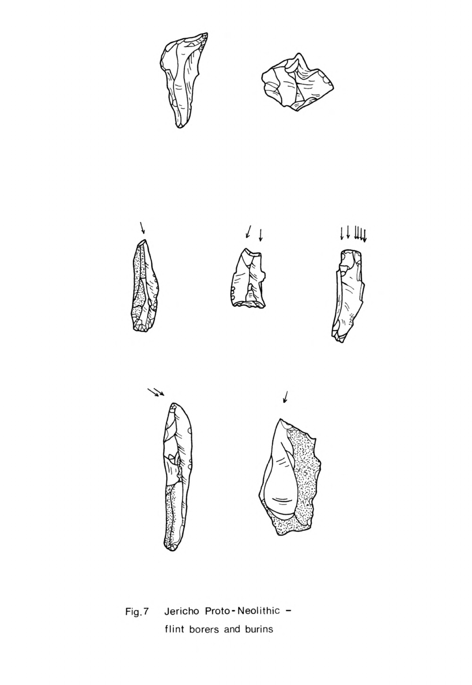
i
Fig.
7
Jericho
Proto-
Neolithic
-
flint
borers
and
burins
grained
flint
although
some
coarse
flint
was
used.
The
flint
was
of
many
different
colours
and
shades,
both
opaque and
translucent,
including
grey,
brown,
veined
purple and
pink;
the
latter two
in
particular
are
usually
thought
of
as
being
distinctive
of
the
"Pre-Pottery
Neolithic
B"
(PPNB)
in
Palestine
but
they
were used
throughout
the
Jericho Natufian
and
Neolithic
sequence.
A
few
fragments of
obsidian,
usually
from
small
blades,
were
found
in
the
Proto-Neolithic
and
PPNA
layers.
This
was the
first
time
that
this
material
had
been
used
in
Palestine. Six pieces
from
the
PPNA
layers
were
analysed
by
Renfrew
and
his
collaborators
in
the
first
major
programme
of
analyses
of
Near
Eastern
obsidian
ever
undertaken.
All
of
them proved
to
have
come
from
giftlik
(source
2b)
in
Anatolia
(Renfrew
et
al.,
1966,
table
l)
I
am
conducting
another programme
of
obsidian
analyses
in
association
with
Bradford
University
in
which
we
have
analysed
three
more
pieces
from
Neolithic
1
levels
at
Jericho,
one
from
the
Proto-Neolithic and
two
from
the
PPNA.
These three
pieces
likewise
came
from
Qiftlik.
Obsidian
from
the
Qiftlik
source
reached
the
Levant
more
regularly
than
that
from
any
other
locality
throughout
the
Neolithic
on
present
evidence.
Tools
in
the
Proto-Neolithic
were
fashioned
on
flakes
and blades struck
from
small
prismatic
or
pyramidal
cores.
Crested
blades
were
a
regular
by-
product.
Flakes
and
blades
usually
had
tiny
prepared
platforms
and
probably
were
struck off
with
a
punch.
Blades
were
short
and
irregular,
most
being
between
3
and 5cm
long
though
a
few
were
as
much
as
6
to
7.5cm
long.
All
the
flake
and
blade
tools
were
small
like
the
waste
material.
The
most numerous
retouched
tools
were
burins
and
scrapers
while
nibbled
blades
were
also
common.
Retouched
blades
and
flakes of
no
specific
type
occurred
quite
frequently.
Although
burins
were
abundant
there
were
very
few
types
(Fig.
7)
for,
apart
from
some
single
and
multiple
blow
burins,
most
were
angle
burins
on
preparation
or
truncation.
The
scrapers
were
a
little
more
varied
(Fig.
8)
consisting
of
flake,
side
and
steep-scrapers
and
end
and
nosed
scrapers
on
blades.
There
were
some
borers
on
flakes
and

Fig.
8
Jericho
Proto
-
Neolithic
-
flint
scrapers
-
95
-
and
blades
with
a
short
point
defined
by
a
little
retouch
(Fig.
7).
Sickle
blades,
that
is
blades
with
silica
sheen,
were
also
found
(Fig.
9)
though
these
do
not
appear
to
have
been
very
common.
They
were
made
on
irregular
flakes
and
blades
and
usually
had
some
retouch,
particularly
on
the
back.
All
were
quite
small
so
several
must
have
been hafted
together
to
make
a
composite
cutting
tool.
These
tools
were
all
finished
with
abrupt
retouch
or
nibbling.
One
new
tool
was the
axe
or
adze
(Fig.
9).
These
had
a
straight
or
convex flaked
cutting
edge
with
a
rounded
or
pointed
butt.
They
were
oval
or
circular
in
cross-section
and
were
flaked
all
over.
These
tools
were
almost
certainly
hafted
and
were
probably
used
for
woodworking.
Most
were
too small to
have
been
used
to
cut
large
pieces
of
timber
so
it
is
likely
that
trees
were
felled
and
split
by
other
means.
This
industry
was
based
more
on
retouched
flakes
than
on
blades
and
so
cannot
be
described
as
a
blade
industry.
The
typological
range
was
restricted
which
suggests
a
fairly
limited
range
of
tool
uses.
Microliths
and
micro-
burins
were
not
found
but
this
may
be
because
the
deposits
were
not
sieved.
Composite
tools
as
such
were
certainly
made
and
as
the
tools
were
so
small
many
of
them
would
have
been
hafted
for
use.
The
raw
material
used
in
the
PPNA
industry
was the
same
as
in
the
Proto-
Neolithic.
The
core
technique
was
also
similar
in
that
most
flakes
and
blades
were
struck
from
prismatic
and
pyramidal
cores,
although
discoid
cores
were
now used
as
well.
Blades
were
still
irregular
although
some
were
longer
than
in
the
Proto-Neolithic
and
had
parallel
sides.
These
larger
blades
were used
for
sickle
blades
and
knives. Some
of
them
were
struck
from
double-ended
cores,
a
few
of
which
were
found
for the
first
time.
A
further refinement
in
the
choice
of
raw
material
was
discernible:
the
larger
blades
were
usually
fashioned
from
fine-grained
purple
and
honey-coloured
flint
while
the
smaller
ones
were
made
on
coarser
raw
material.
Burins,
scrapers
and
nibbled
blades
were
still
the
most
common
tools.
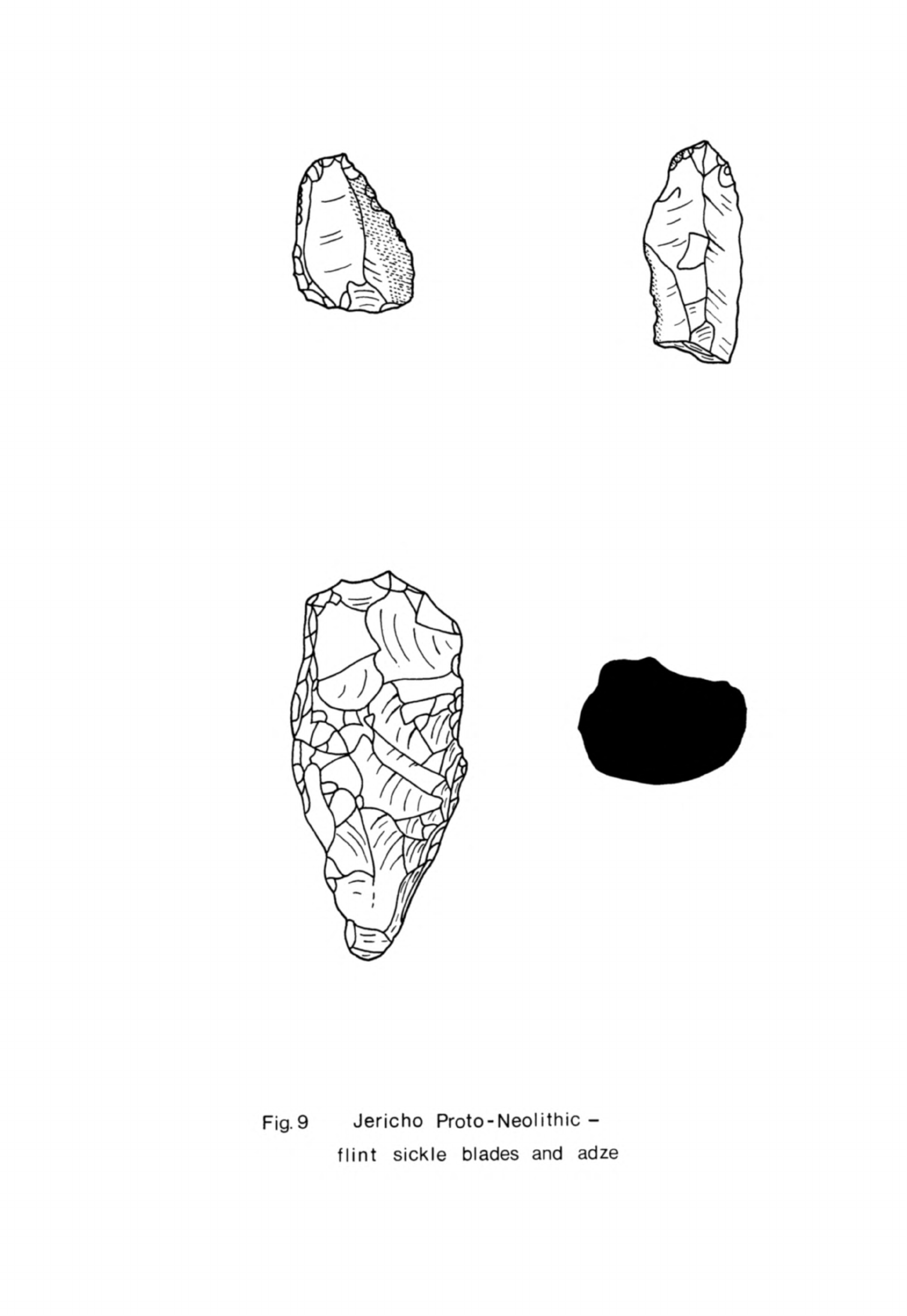
Fig.9
Jericho
Proto-Neolithic
-
flint
sickle
blades
and
adze
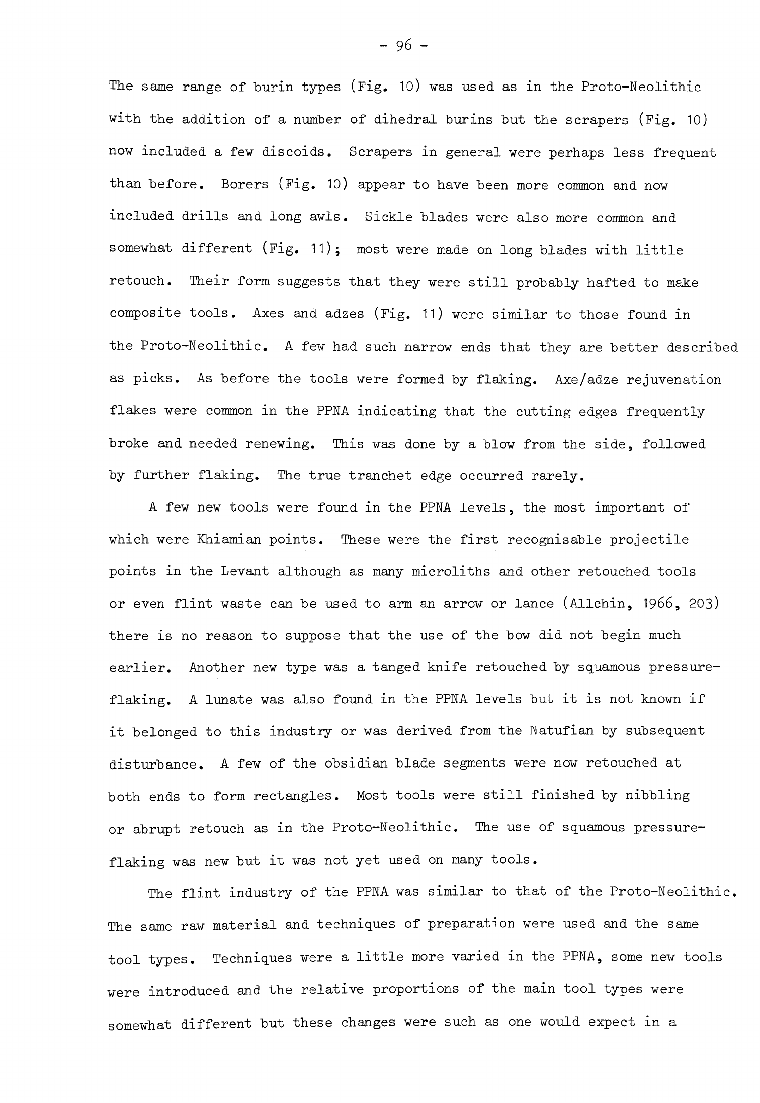
-
96
-
The
same
range of
burin
types
(Fig.
10)
was
used
as
in
the
Proto-Neolithic
with
the
addition
of
a
number
of
dihedral burins
but
the scrapers
(Fig.
10)
now
included
a
few
discoids.
Scrapers
in
general
were
perhaps
less
frequent
than before.
Borers
(Fig.
10)
appear
to
have
been
more
common
and
now
included
drills
and
long
awls.
Sickle
blades
were
also
more
common
and
somewhat different
(Fig.
11);
most
were
made
on
long
blades
with
little
retouch.
Their
form
suggests
that
they
were
still
probably
hafted
to
make
composite
tools.
Axes
and
adzes
(Fig.
11)
were
similar
to
those
found
in
the
Proto-Neolithic.
A
few
had
such
narrow
ends
that
they
are
better
described
as
picks.
As
before
the
tools
were
formed
by
flaking.
Axe/adze rejuvenation
flakes
were
common
in
the
PPNA
indicating
that
the
cutting
edges
frequently
broke
and
needed
renewing.
This
was
done
by
a
blow
from
the
side,
followed
by
further
flaking.
The true
tranchet
edge
occurred
rarely.
A
few
new
tools
were
found
in
the
PPNA
levels,
the
most
important
of
which
were
Khiamian
points.
These
were
the first
recognisable
projectile
points
in
the
Levant
although
as
many
microliths
and
other
retouched
tools
or even
flint
waste
can
be
used
to
arm
an
arrow
or
lance
(Allchin,
1966,
203)
there
is
no
reason
to
suppose
that
the
use of
the
bow
did
not
begin
much
earlier.
Another
new
type
was
a
tanged
knife
retouched
by
squamous
pressure-
flaking.
A
lunate
was
also
found
in
the
PPNA
levels
but
it
is
not
known
if
it
belonged
to
this
industry
or
was
derived
from
the
Natufian
by
subsequent
disturbance.
A
few
of the
obsidian
blade
segments
were
now
retouched
at
both
ends
to
form
rectangles.
Most
tools
were
still
finished
by
nibbling
or
abrupt
retouch
as
in
the
Proto-Neolithic.
The
use
of
squamous
pressure-
flaking
was
new
but
it
was
not
yet
used
on
many
tools.
The
flint
industry
of
the
PPNA
was
similar
to
that
of
the
Proto-Neolithic.
The
same
raw
material
and
techniques
of
preparation
were used
and
the
same
tool
types.
Techniques
were
a
little
more
varied
in
the
PPNA,
some
new
tools
were
introduced
and
the
relative
proportions
of
the
main
tool
types
were
somewhat
different
but
these
changes
were
such
as
one
would
expect
in
a
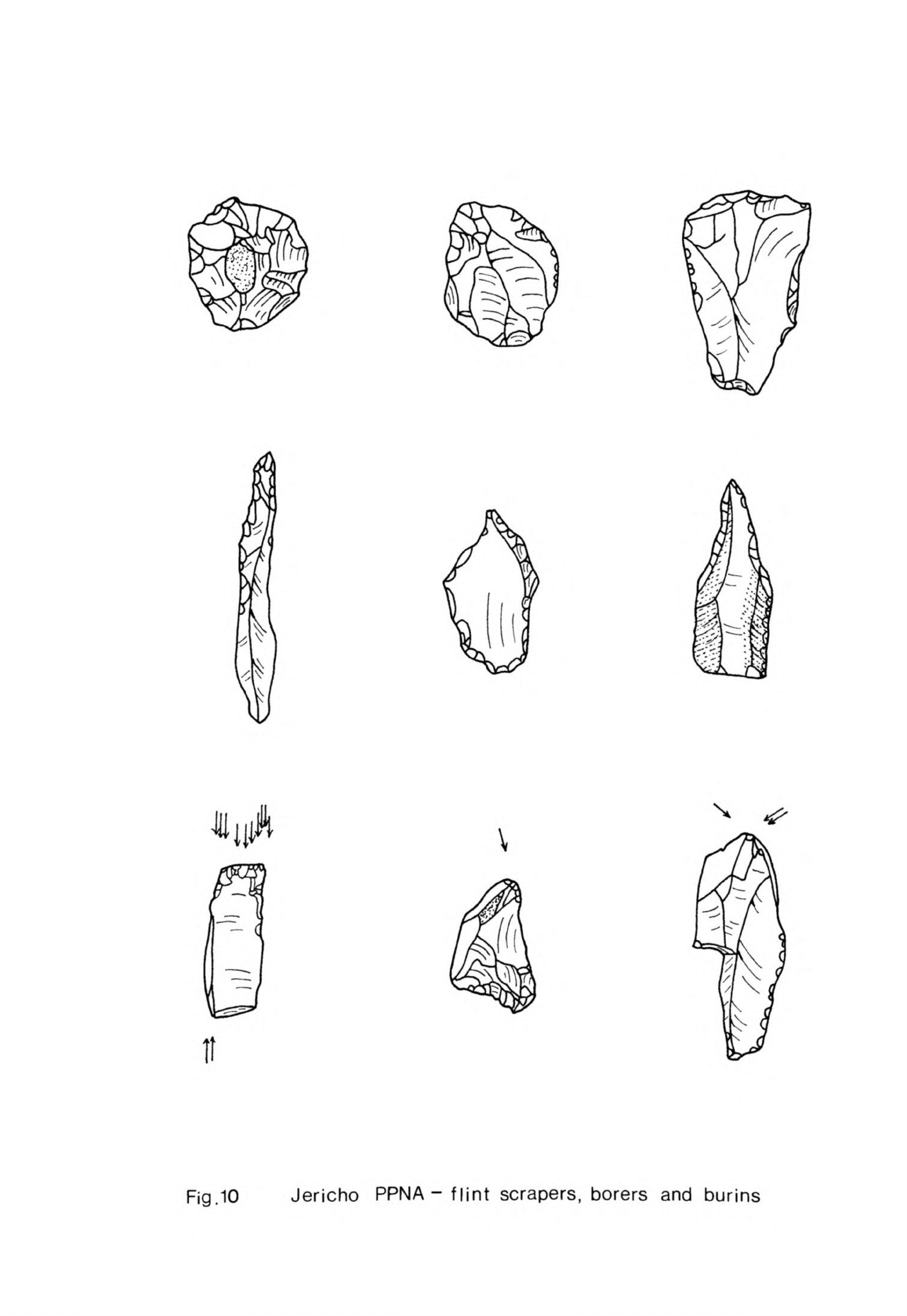
\
It
Fig.
10
Jericho
PPNA-flint
scrapers,
borers
and
burins
Fig.
11
Jericho
PPNA-flint
adze
and
sickle
blades
-
97
-
long-lived
industry.
Gradual
changes
would
take
place
with
the
passage
of
time and
new
tool
types
would
"be
developed
in
response
to
new
needs.
As the
excavated
material
represented
only
some
of
the
activities
that
were
practised
on
the
site
differences
were
"bound
to
occur
from
level
to
level
which
would
affect
the
total
sample we
have
of
the
industry.
This
Neolithic
flint
industry
had
many
similarities
with
the
Natufian
industry
at
Jericho. The
same
varieties
of
raw
material
and
the
same
techniques
of
production
of
small
"blades
and
flakes
from
prismatic
cores
were used
in
the
Natufian.
The
waste
blades
and
flakes
were
similar
and
"both
this
component
and
the
tools
were
all
small;
neither
could
be
described
as
a
blade
industry, not
before
the
evolved
PPNA
anyway. Some
of
the
tool
types
such
as
the
scrapers, sickle
blades
and
borers
were
common
to
both
industries.
There
were
differences
of
course:
microliths
and
the
microburin
technique
appear
to
have
been
absent
in
the
Neolithic
industry
for
example
but
never-
theless,
the
similarities
are
striking.
Since
they
embrace
raw
material,
techniques
of
production
and
tool
types
it
would
appear
that
the
Neolithic
industry
developed
directly
from
the
Natufian.
One
can
go
further
and
suggest
that
for
such
an
industry
to
be
continued
in
this
way
the
population
must
have remained
the
same.
Although
other
cultural
and
economic
changes
were
taking
place
the
earlier
Neolithic
population
of
Jericho
was
descended
from
the
Natufian
inhabitants
of
the
area.
It
is
very difficult
to
determine
when
the
Proto-Neolithic/PPNA
at
Jericho
began
and
how
long
it
lasted
because
although no
less
than
eleven
llf
C
determinations
have
been
made
on
samples
from
PPNA
levels the
dates
do
not
form
a
consistent
series.
Two
determinations
made
when
14
C
dating
was
a
new
technique,
6850
±
160
B.C.
F-39
(Kenyon,
1959,
7)
and
6775
±
210
E.G.
F-kO
(Henry,
Servello,
197^,
37)
9
should
probably
be
ignored
from
the
outset
as
they
give
no
more
than
a
general
indication
of
the
age
of
the
deposits.
The
remaining
determinations
were
all
carried
out
by
the
British
Museum
and
Philadelphia
laboratories,
often
on
samples
from
the
same
phases.
-
98
-
Unfortunately
these
two
series
of
dates
differ
by
as
much
as
500
or
600
years,
the
British
Museum
dates
"being
the
older.
The
earliest
dated
phase
is
one
immediately
after
the
construction
of
the
PPNA
wall
and
tower.
The
two
British
Museum
dates
for
this
are
8350
±
500
B.C.
BM-250
(Radiocarbon
11,
1969,
290)
and
8300
±
200
B.C.
BM-105 (Radiocarbon
5,
1963,
10?)
but
the
Philadelphia
date
is
7825
±
110
B.C.
P-378
(Radiocarbon
5,
1963,
8U).
There
is
another
series
of dates
for
phases
late
in
the
PPNA:
8350
±
200
B.C.
BM-106
for
a
phase
succeeding
stage
VI
of
the
defences
and
8230
±
200
B.C.
BM-110
(Radiocarbon
5,
1963,
107)
for
the
final
destruction
of
the
wall,
both
of
which
may
be
compared
with
7705
±
8U
B.C.
P-379
(Radiocarbon
5,
1963,
8U),
also
for
a
stage
succeeding
stage
VI.
The
problem
is
made
even
more
difficult
by
other
dates
obtained
more
recently,
fkhO
±
150
B.C.
BM-251
for
stage
VI
and
7370
±
150
B.C.
BM-252
(Radiocarbon
11,
1969,
290)
for
a
phase
succeeding
stage
VII,
both
much
later
than
the
series
above
and
which
may
be
aberrant.
One
other
date
should
be
mentioned
here
to give
a
complete
picture,
7632
± 89
B.C.
P-377;
this
is
for the
earliest
PPNA
occupation
in
Trench
E
(I,
II,
V)
and
so
unlike
all
the
other
determinations
mentioned
which
were
obtained
from
material
in
Trench
I.
One
of
the
difficulties
with
these
determinations
is
that
the
charcoal
from
which
they
were
obtained
was
excavated
many
years
ago
and
most of
the
dating
was
done
soon
after
the
excavations
were
finished.
This
means
that
the
dates
are
probably
not
very
exact,
although
it
does
not
explain
the
discrepancies
between
dates
from
the
two
laboratories.
This
has
to
be
a
accounted
for
by
different
sample
preparation
and
counting
procedures.
If
one
considers
the
British
Museum
dates
alone
then
it,would
appear
that
the
PPNA
at
Jericho
began
about
8500
B.C.
although from
the
Philadelphia
dates
8000
B.C.
would
be
more
correct.
In
either
case
the
Proto-Neolithic
settle-
ment
must
have
been
founded
some
time
before.
The
end
of
the
PPNA
came
about
8000
B.C.
on
the
British
Museum
dates
or
7500
B.C. on
those
from
Philadelphia.
From
these
determinations
it
is
possible
to
argue
for
either

-
99
-
a
long
duration
of
the
PPNA
from
8500
to
7500
B.C.
or
for
a
much
shorter
sequence
of
two
or
three
hundred
years. For
the
moment
it
is
"best
to
"be
cautious
and
to
take
an
average
of
the
dates
recognising
that
this
can
only
be
an
estimate.
On
this
"basis
PPNA
may
have
"begun
about
8200
or
8300
B.C.
and
ended
about
7700
or
7800
B.C.
The
Proto-Neolithic
may
thus
be
dated
to
about
8500
B.C.,
an
estimate
that
accords
reasonably
veil
with
the
date
suggested
earlier
for the
end
of
Mesolithic
2
in
the
Levant.
Nahal
Oren
The
site
of
Nahal
Oren
is
situated
on
the
north
side
of
the
Wadi
Fellah
and
consists
of
a
small
cave
with
a
terrace
in
front
which
slopes
steeply
down to
the
wadi
floor.
It
has
been
extensively excavated
by
three
teams
in
separate
campaigns.
The
first
excavation
was
in
the
cave
and
on
the
terrace
in
front (Stekelis,
19^-2,
U).
It
was
believed
that
the
site
had
been
occupied
in
the
Aurignacian
and
Mesolithic
2.
The
second
series
of
excavations
exposed
a
large
part
of
the
terrace
and
showed
that
it
had
been
occupied
in
Mesolithic
1
and
2
and
the
Pre-Pottery
Neolithic
(Stekelis
9
Yizraely,
1963,
Iff).
The
third
excavation
took
place
on
the
terrace
a
little
to
the
west
of
the
area
already
dug.
It
was
intended
that
the
soundings
here
should
confirm
the
stratigraphic
sequence
of
the
site
and
provide
samples
of
organic
remains
from
which
the
economies
of
the
different
phases
of
occupation
could
be
determined
(Noy
et
al.,
1973,
75ff).
The
occupation
sequence
at
Nahal
Oren
covers
a
long
period
of
time
yet
the
remains
of
the
superimposed
phases
of
the
settlement
are
less
than
Urn
deep
(Noy
et
al.,
1973,
fig.
2b).
Much
of
the
deposit
consists
of
stones
and
other
debris
washed
down
from
the
steep
slopes
above.
Although
the
archaeological
cultural
sequence
is
complete
from
Mesolithic
1
to
the
Pre-
Pottery
Neolithic
B
there
is
too little
occupation
deposit
on
the
site
for
it
to
have
been
continuously
occupied
by
man.
It
is
more
likely
that
occupa-
tion
was
discontinuous
but
that
people
returned
to the
site
in
each
cultural
phase.
-
100
-
The
Neolithic
occupation
deposits
were
found
to
be
stratified
directly
above
Natufian
layers
in
the
excavations
of
"both
Stekelis
and
Yizraely
(Noy)
and
Noy,
Legge
and
Higgs.
In
the
most
recent excavations
these
deposits
have
been
divided
into
a
lower
series,
layers
II
and
III,
which
has
been
equated
with
the
PPNA
at
Jericho
and
layer
I
above
ascribed
to the
PPNB
(Noy
et'al.
a
1973,
86).
Two
stone-walled
structures
with
associated
floors
and
hearths,
considered
to
be
houses,
were
found
in
the
lower,
PPNA
layers
(Noy
et
al.,
1973,
78ff).
These
layers
cannot
be
linked
directly
with
stratum
II.
described
as
PPNA
in
the
earlier
excavations
(Stekelis,
Yizraely,
19639
10)
but
it
would
appear
that
the
much
more
extensive
structural
remains
excavated
then
belonged
to
the
same
cultural
phase.
The
stratigraphical
position
of
both
was the
same
in
their
respective
sequences,
sandwiched
between
Mesolithic
2
and
PPNB
layers
(Stekelis,
Yizraely,
1963,
2;
Noy
et
al.,
1973,
fig.
2b).
Stratum
II
consisted
of
a
village
of
at
least
13
subcircular
structures
(Fig.
12),
most
of
which
were
probably
houses
(Stekelis,
Yizraely,
1963,
hff,
fig.
3).
The
buildings
were
from
2
to
tan
in
diameter,
the
smaller
ones
perhaps
serving
as
stores
or
workshops.
They
were
built
on
a
descending
series
of
four
terraces
cut
back
into
the
natural
slope
and
set
so
close
together
that
the
walls
of
some
interlocked.
These
walls
made
of
rough
stones
were
up
to
0.8m
wide
and
stood
about
1m
high.
Originally
they
must
have
carried
roofs
of
timber
with
perhaps
reeds
and
mud.
The
buildings
had
earth
or
pebble
floors,
which
had
been
renewed
in
some
instances,
and
stone-
lined
hearths
sunk
in
their
floors.
Cup-marked
stones
were
often
found
associated
with
these
hearths;
as
the
cup
marks
were
quite
small
they
may
have been used
in
some
craft
activity
rather
than
as
roof
supports
as
Stekelis
and
Noy
suggested.
The
doors
of
these
dwellings
opened
down
the
slope
towards
the
bottom
of
the
wadi.
Allowing
for
the
differences
in
situation
and
building
material,
these
structures
were
quite
similar
to
the
houses
of
PPNA
Jericho.
Both
types
were
round
or
subcircular
with
a
single
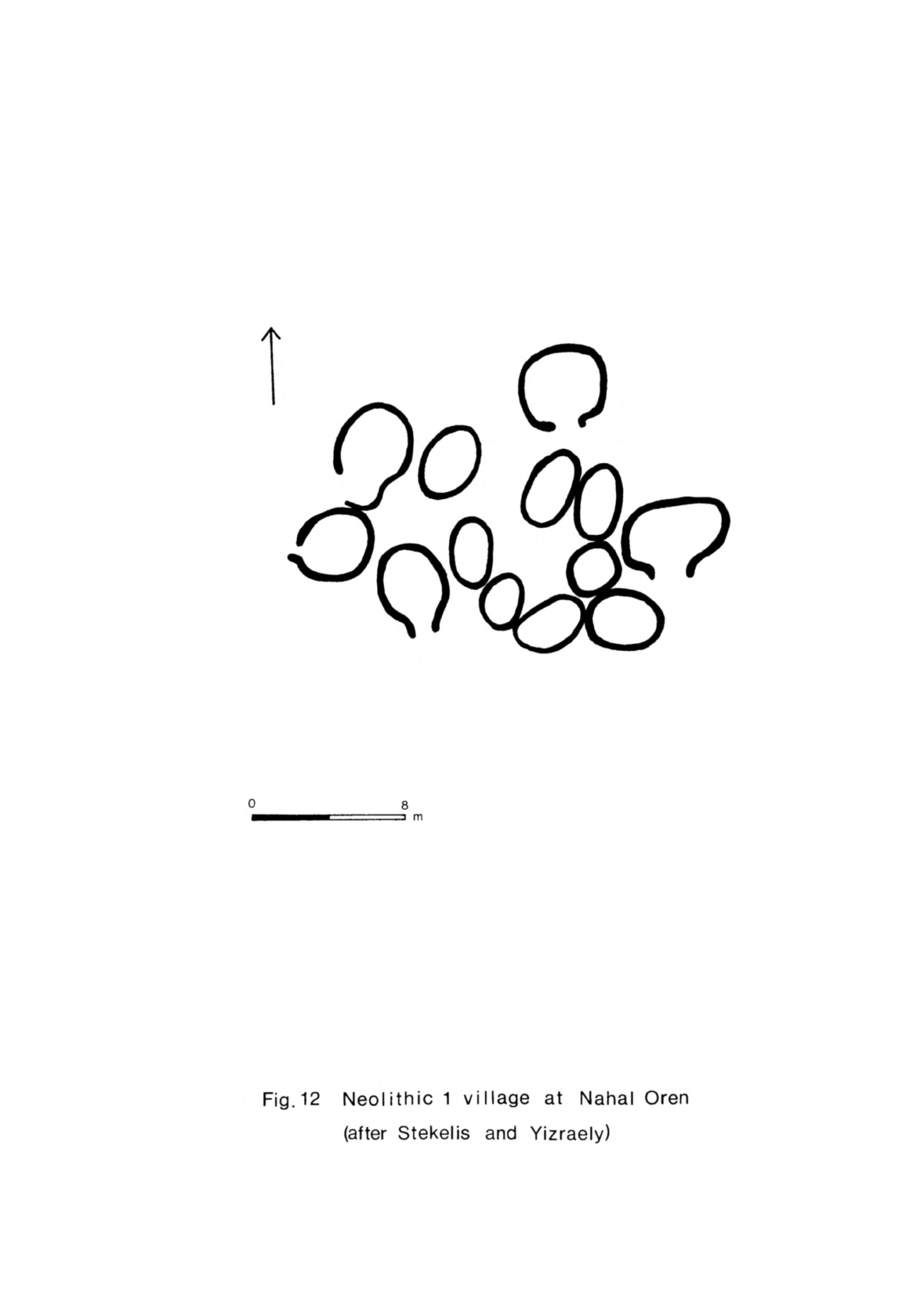
A
0
8
m
Fig.
12
Neolithic
1
village
at
Nahal
Oren
(after
Stekelis
and
Yizraely)
-
101
-
entrance
and
a
number
of
the
Nahal
Oren
buildings
-were
dug
at
least
partly
into
the
hillside,
so
resembling
the
semi-subterranean
houses
at
Jericho.
The
walls
of
the
Nahal
Oren
buildings
were
lov
as at
Jericho,
though
broad
enough
to
support
a
superstructure.
It
is
likely
that
both
types
had
a
conical,
tent-like
roof
which
sloped
down to
the
tops
of
the
walls
and
was
supported
by
one
or
more
posts
within
the
building.
Only
one
burial
has
been
reported
for
these
levels
at
Nahal
Oren
(Noy
et
al.,
1973,
79).
This
was
a
semi-flexed
skeleton
laid
on its
right
side
in a
shallow
pit
without
accompanying
grave
goods.
The
skull was
missing
although
the
mandible
was
in
position.
This
would
appear
to
have
been
another
early
example
of
the
practice
of
removing
skulls
from
corpses
which
was
so
common
later
in
the
Neolithic.
As
this
burial
was the
only
one
reported
from
inside
the
settlement
at
this
period
it
is
likely
that
most
of
the
inhabitants
were
buried
elsewhere,
in
contrast
with
the
practice
in
Mesolithic
2
and
later
in
the
Neolithic.
The finds
from
these
levels
of
the
Neolithic
settlement
were
restricted
in
type,
lacking
the
elaboration
of
material
culture
found
on
some
Mesolithic
2
sites
and
later
in
the
Neolithic.
Cylindrical
pestles
and
plano-convex
rubbing
stones
of
limestone
or
basalt were
quite
common
(Stekelis,
Yizraely,
1963,
8ff),
the
latter
material
being
imported
probably from
Galilee.
Only
one
hollow
quern,
on the
other
hand,
was
found
in
stratum
II
and
none
was
reported
for
Nahal
Oren
IV
-
II.
A
number
of
other
limestone
bowls,
dishes
and
platters
were
found
in
stratum
II,
several
of
them
ground
thin.
One
pebble
incised
as
a
female
figurine
was
also
discovered
in
house
16.
Bone
tools
were
the
second
principal
category of artifacts
but
these
were
quite
restricted
in
range.
Most
were
simple
borers
of
varying
sizes.
A
number
of
small,
cylindrical
bone,
stone
and
shell
beads
was
found
in
the
most
recent
excavations.
One
was
a
malachite
spacer
bead
(BM
no.
1973
7-11886),
the
material
for
which
must
have
been
imported
from
some
distance
away,
perhaps
as
far
south
as
the
Wadi
Arabah
or Sinai.
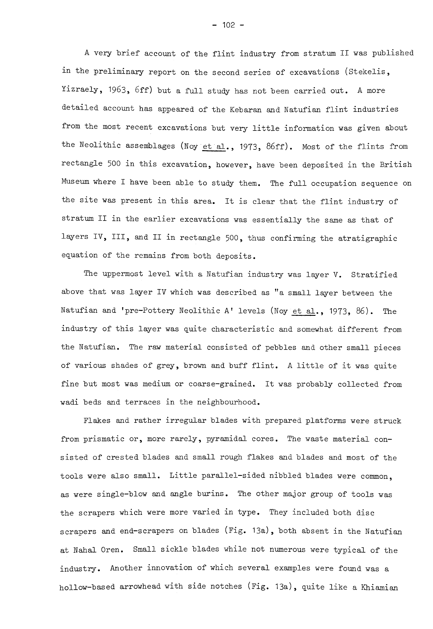
-
102
-
A
very
brief
account
of
the
flint
industry from
stratum
II
was
published
in
the
preliminary
report
on
the
second
series of
excavations
(Stekelis
9
Yizraely,
1963,
6ff)
but
a
full
study
has
not
been
carried
out.
A
more
detailed
account
has
appeared
of
the
Kebaran
and
Natufian
flint
industries
from
the
most
recent
excavations
but
very little
information
was
given
about
the
Neolithic
assemblages
(Noy
et
al.,
1973,
86ff).
Most
of
the
flints
from
rectangle
500
in this
excavation,
however,
have
been deposited
in
the
British
Museum
where
I
have
been
able
to
study
them.
The
full
occupation sequence
on
the
site
was
present
in
this
area.
It
is
clear
that
the
flint
industry
of
stratum
II
in
the
earlier
excavations
was
essentially
the
same
as
that
of
layers
IV,
III,
and
II
in
rectangle
500,
thus
confirming
the
atratigraphic
equation
of
the
remains
from both
deposits.
The
uppermost
level
with
a
Natufian
industry
was
layer
V.
Stratified
above
that
was
layer
IV
which
was
described
as
"a
small
layer
between
the
Natufian
and
'pre-Pottery
Neolithic
A
1
levels
(Noy
et
al.,
1973,
86).
The
industry
of
this
layer
was
quite
characteristic
and somewhat
different
from
the
Natufian.
The
raw
material
consisted
of
pebbles
and
other small pieces
of
various
shades
of
grey,
brown
and
buff
flint.
A
little
of
it
was quite
fine
but
most was
medium
or
coarse-grained.
It
was
probably
collected
from
wadi
beds
and
terraces
in
the
neighbourhood.
Flakes
and
rather
irregular
blades
with
prepared
platforms
were
struck
from prismatic
or,
more
rarely,
pyramidal
cores.
The
waste
material
con-
sisted
of
crested
blades
and
small rough
flakes
and
blades
and
most
of
the
tools
were
also
small.
Little
parallel-sided
nibbled
blades
were
common,
as
were
single-blow
and
angle
burins.
The
other
major
group
of
tools
was
the
scrapers
which
were
more
varied
in
type.
They included
both
disc
scrapers
and
end-scrapers
on
blades
(Fig.
13a),
both
absent
in
the
Natufian
at
Nahal
Oren.
Small
sickle
blades
while
not
numerous
were
typical
of
the
industry.
Another
innovation
of
which
several
examples
were
found
was
a
hollow-based
arrowhead with
side
notches
(Fig.
13a),
quite
like
a
Khiamian
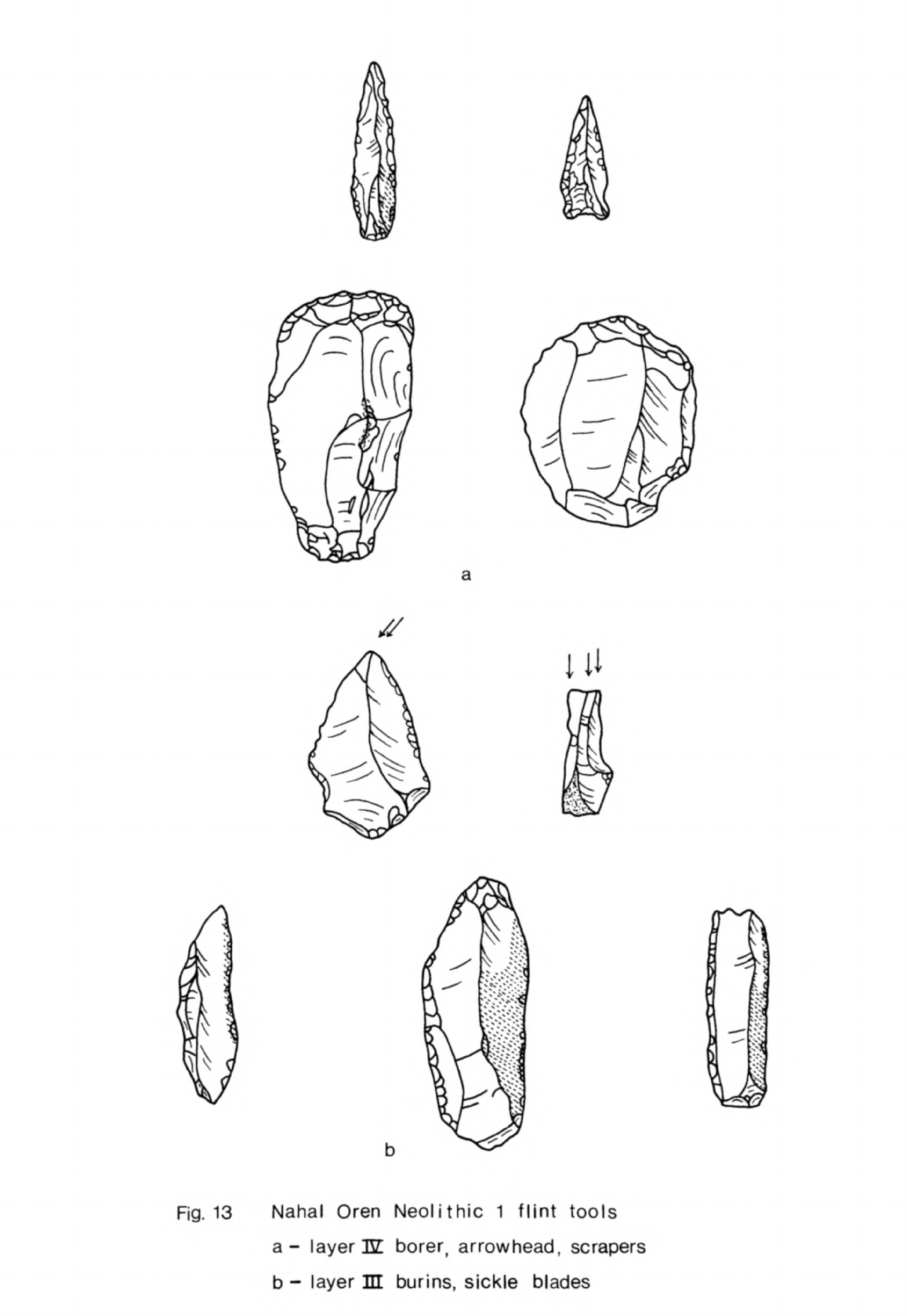
a
Fig. 13
Nahal
Oren
Neolithic
1
flint
tools
a-
layer
12
borer,
arrowhead,
scrapers
b
-
layer
in
burins,
sickle
blades
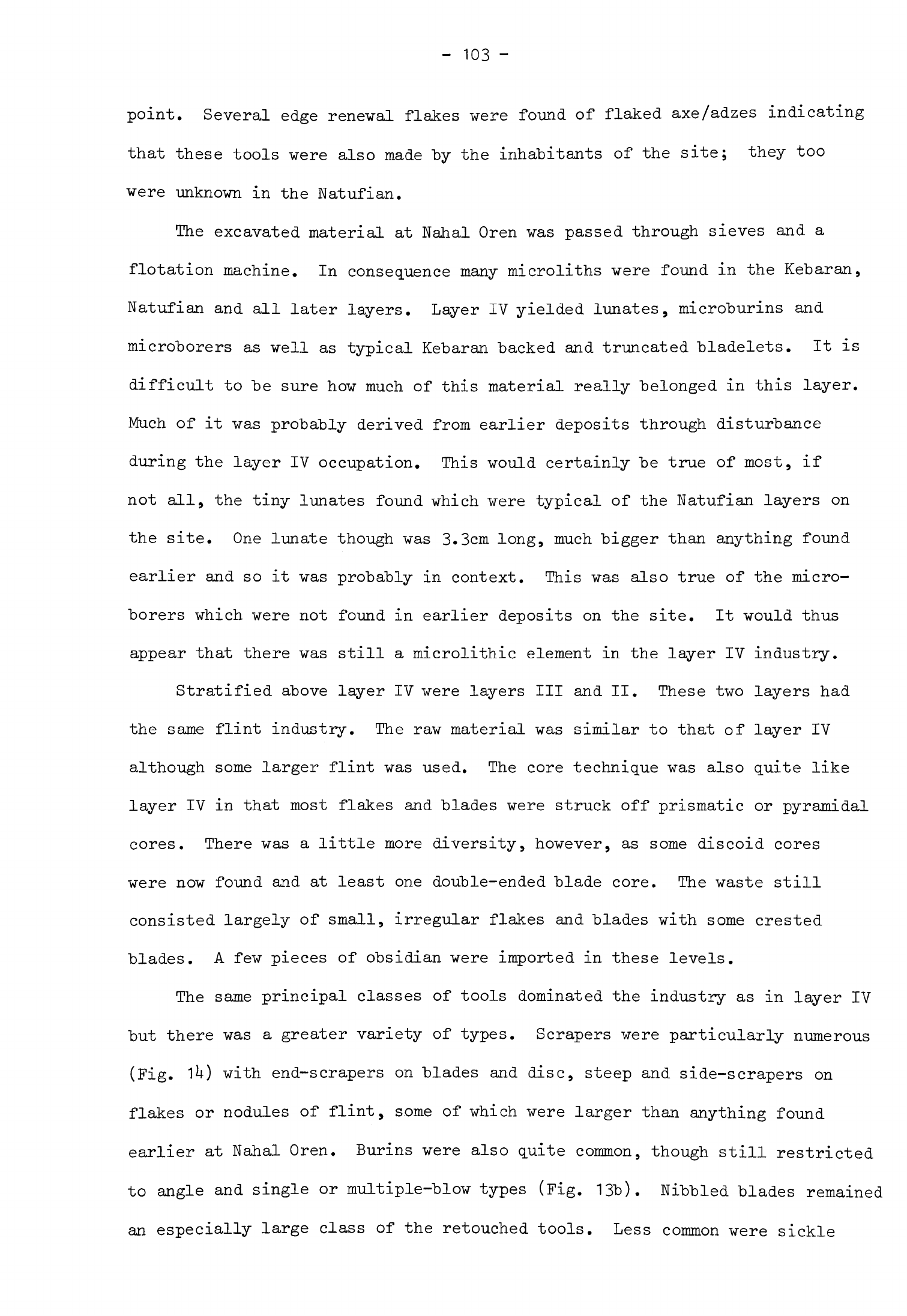
-
103
-
point.
Several
edge
renewal
flakes
were
found
of
flaked
axe/adzes
indicating
that
these
tools
were
also
made
by
the
inhabitants
of
the
site;
they
too
were
unknown
in
the
Natufian.
The
excavated
material
at
Nahal
Oren
was
passed
through
sieves
and
a
flotation
machine.
In
consequence
many
microliths
were
found
in
the
Kebaran,
Natufian
and
all
later
layers.
Layer
IV
yielded
lunates,
microburins
and
microborers
as
well
as
typical
Kebaran
backed
and
truncated
bladelets.
It
is
difficult
to
be
sure
how
much
of
this
material
really
belonged
in
this
layer.
Much
of
it
was
probably
derived from
earlier
deposits
through
disturbance
during
the
layer
IV
occupation.
This
would
certainly
be true
of
most, if
not
all,
the
tiny
lunates
found
which
were
typical
of
the
Natufian
layers
on
the
site.
One
lunate
though
was
3.3cm
long,
much
bigger
than
anything found
earlier
and
so
it
was
probably
in
context.
This
was
also
true
of
the
micro-
borers
which
were
not
found
in
earlier
deposits
on
the
site. It
would
thus
appear
that
there
was
still
a
microlithic
element
in
the
layer
IV
industry.
Stratified
above
layer IV
were
layers
III
and
II.
These
two
layers
had
the same flint
industry.
The raw
material
was
similar
to
that
of
layer
IV
although
some
larger
flint
was
used.
The
core
technique
was
also
quite like
layer
IV
in
that
most
flakes
and
blades
were
struck off
prismatic
or
pyramidal
cores.
There
was
a
little
more
diversity,
however,
as
some
discoid
cores
were now
found
and
at
least
one
double-ended blade
core.
The
waste
still
consisted
largely
of
small,
irregular
flakes
and
blades
with
some
crested
blades.
A
few
pieces
of
obsidian
were
imported
in
these
levels.
The
same
principal
classes
of
tools
dominated
the
industry
as
in
layer
IV
but
there
was
a
greater variety
of
types.
Scrapers
were
particularly
numerous
(Fig.
1*0
with
end-scrapers
on
blades
and
disc,
steep
and
side-scrapers
on
flakes or
nodules
of
flint,
some
of
which
were
larger
than
anything
found
earlier
at
Nahal
Oren.
Burins
were
also
quite
common,
though
still
restricted
to
angle
and
single
or
multiple-blow
types
(Fig.
13b).
Nibbled
blades
remained
an
especially
large
class
of
the
retouched
tools.
Less
common
were
sickle
a
Fig.
14
Nahal
Oren
Neolithic
1
flint
tools
a
borers
c
scrapers
b
point
d
adze
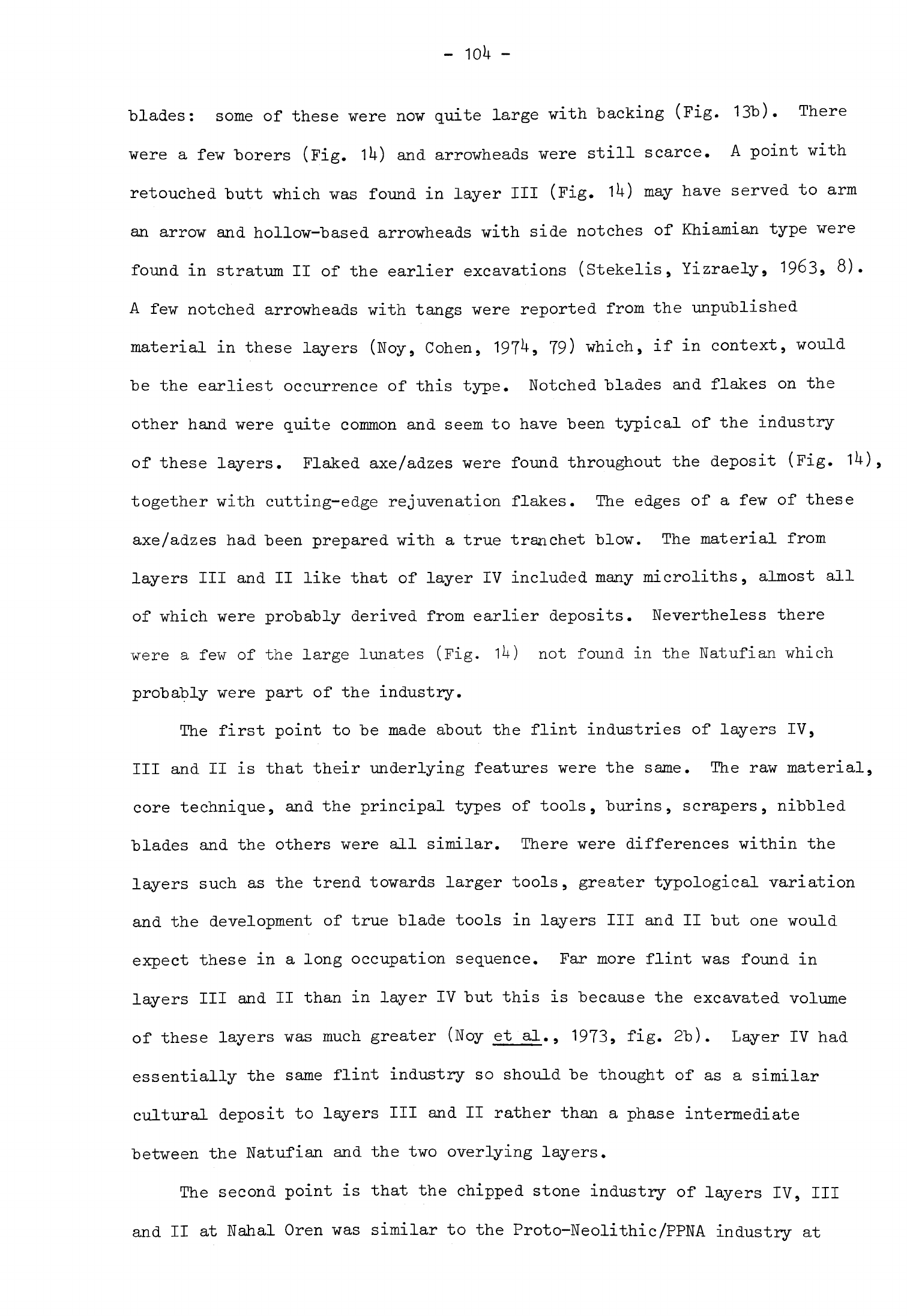
blades:
some of
these
were
now
quite
large
with
backing
(Fig.
13b).
There
were
a
few
borers
(Fig.
1U)
and
arrowheads
were
still
scarce.
A
point
with
retouched
butt
which
was
found
in
layer
III
(Fig.
1^)
may
have served
to
arm
an
arrow
and
hollow-based
arrowheads
with
side
notches
of
Khiamian
type
were
found
in
stratum
II
of
the
earlier
excavations
(Stekelis,
Yizraely,
1963,
8)
A
few
notched
arrowheads
with
tangs
were
reported
from
the
unpublished
material
in
these
layers
(Noy,
Cohen,
197U,
79)
which,
if
in
context,
would
be
the
earliest
occurrence
of
this
type.
Notched
blades
and
flakes
on
the
other
hand
were
quite
common
and
seem
to
have
been
typical
of
the
industry
of
these
layers.
Flaked
axe/adzes
were
found
throughout
the
deposit
(Fig.
together
with
cutting-edge
rejuvenation
flakes.
The
edges
of
a
few
of
these
axe/adzes
had
been
prepared
with
a
true
tranchet
blow.
The
material from
layers
III
and
II
like that of
layer IV
included
many
microliths,
almost
all
of
which
were
probably
derived from
earlier
deposits.
Nevertheless
there
were
a
few
of
the
large lunates
(Fig.
1U)
not
found
in
the
Natufian
which
probably were
part
of
the
industry.
The
first
point
to
be
made
about
the
flint
industries
of
layers
IV,
III
and
II
is
that
their
underlying
features
were
the
same.
The
raw
material,
core
technique,
and
the
principal
types
of
tools,
burins,
scrapers,
nibbled
blades
and
the
others
were
all
similar.
There
were
differences
within
the
layers
such
as
the
trend
towards
larger
tools,
greater
typological
variation
and
the
development
of
true
blade
tools
in
layers
III
and
II
but
one
would
expect
these
in
a
long
occupation
sequence.
Far
more
flint
was
found
in
layers
III
and
II
than
in
layer
IV
but
this
is
because
the
excavated
volume
of
these
layers
was
much
greater
(Noy
et
al., 1973
9
fig.
2b).
Layer
IV
had
essentially
the
same
flint
industry
so
should
be
thought
of
as
a
similar
cultural
deposit
to
layers
III
and
II
rather
than
a
phase
intermediate
between
the
Natufian
and
the
two
overlying
layers.
The
second
point
is
that
the
chipped
stone
industry
of
layers
IV,
III
and
II
at
Nahal
Oren
was
similar
to
the
Proto-Neolithic/PPNA
industry
at
-
105
-
Jericho.
The
similarities
extended
through
the
techniques
of
tool
prepara-
tion,
the
overall
size
of
the
tools
and
the
principal
tool
types;
they
even
included
such
distinctive
innovations
as
the
flaked
axe/adzes
and
Khiamian
points.
There
were
some
differences
"between
these
two
industries,
the
most
obvious
one
being
raw
material.
The
inhabitants
of
both
sites
used
local
sources
of
flint,
deliberately
selecting
small
chunks
and
wadi pebbles,
yet
the
different
colours,
textures
and
striking
properties
of the
material from
Nahal
Oren
and
Jericho
are
noticeable
and
give
a
slightly
different
look
to
each
collection. The
second
difference
was
in
the
proportions
of
the
main
types
of
tool
at
each
site.
Burins
and
borers,
for
instance,
appear
to
have
been
less
common
at
Nahal
Oren
than
at
Jericho.
Such
differences
may
well
be
accounted
for
by
the different
situations
of
the
two
sites
and
the
different
activities
practised
on
them.
Variations
in
proportions
of
tools
did not
extend
throughout
the
industries,
however:
scrapers
and the
ubiquitous
nibbled
blades
seem
to
have
been
equally
common
and
sickle
blades
equally
rare
at
both
sites.
It
is
also
doubtful
if
many
microliths
were used
at
either
Nahal
Oren
or
Jericho.
The
third
point
is
that
the
industry
of
layers
IV,
III,
and
II
at
Nahal
Oren
appears
to
have
been
a
direct
development
of
the
Natufian
industry
on
the
same
site
in
the
same
way
as
the
Proto-Neolithic/PPNA
industry
at
Jericho
was
derived
from
the
Natufian
there.
The
raw
material
used
in
the
Natufian
was the
same
local
flint
of
small
chunks
and
pebbles.
This
was
prepared
in
the
same
basic
way
as
in
layers
IV,
III
and
II
with
small
blades
and
flakes
being
struck
off
prismatic and
pyramidal
cores.
The
range
of
tools was
small,
consisting
mainly
of
angle
and
multiple-blow
burins
and scrapers
(Noy
et
al.,
1973,
fig.
6).
The
scrapers
were
usually
made
on
flakes,
steep
scrapers
being
quite
common;
end-scrapers
on
blades
were
present
but
only
in
small
quantities.
Backed
and
other
irregularly
retouched
blades
were
used
as
sickle
blades
although
these
were
not
very
numerous.
Microliths
of
which
lunates
were
the
most
common
type
formed
a
major
component
of
the
industry.
-
106
-
Although
the
making
of
microliths
seems
to
have
diminished
rapidly
after
the
Natufian,
large lunates
were
still
being
made
in
layers
IV,
III
and
II.
Both
the
techniques
of
manufacture
and
the
range
of
tools
were
common
to
this
Natufian
industry
and
that
of
the
overlying
layers.
This
strongly
suggests
that
the
later
industry
developed
from
the
Natufian
at
Nahal
Oren
and
that
therefore,
as
at
Jericho,
there
was
no
major
replacement
of
popula-
tion
between
the
Natufian
and the
earliest
Neolithic
occupation.
The
early
Neolithic
at
Nahal
Oren
cannot
be
independently
dated
as
there
are
no
l
^C
dates
for
this
phase.
The
close
typological
similarity
between
the
artifacts
from
Nahal
Oren
and
Jericho
in
this
phase
suggests
that
they
were
contemporary
and
that
Nahal
Oren
was
therefore
inhabited
during
the
Proto-Neolithic/PPNA
phase
at
Jericho.
Mugharet
el
Wad
There
were
indications
of
transient
occupation
contemporary
with
Nahal
Oren
IV
to
II
nearby
at
Mugharet
el
Wad.
A
few
arrowheads
were
found
here
in
layer
B1
(Garrod,
Bate,
1937
9
30),
described
as
Upper
Natufian.
There
is
no
doubt
that
the
bulk
of
the
material
in
this
layer
was
derived
from
a
Natufian
settlement
but
in
the
presence
of
the
arrowheads
hints
at
a
slightly
later
phase
of
occupation
as
well.
Although
two
of
the
arrowheads
were
later
Neolithic
types
at
least
one
was
a
Khiamian
point
(Garrod,
Bate,
1937»
pi.
VIII,
31)
which
at Jericho
and
Nahal
Oren
was
associated
with
the
earliest
post-Natufian
industry.
The
picks
and
axe
or
adze
butt
(Garrod,
Bate,
1937,
32)
were
almost
certainly
post-Natufian
also.
Many
of
the
other
tools
in
layer
B1
would
not
be
out
of
place
in
such
a
context
so
it
would
appear
probable
that
there
was
some
transient
use
of
Mugharet
el
Wad
by
human
groups
using
the
same
tools
as
Nahal
Oren
IV
to
II
and
Jericho
Proto-Neolithic/PPNA.
Evidence
was
found
in
layer
A
of
such
temporary
use
of
the
site
in
succeeding
stages
of
the
Neolithic
and
later
periods
also
(Garrod,
Bate,
1937,
29).
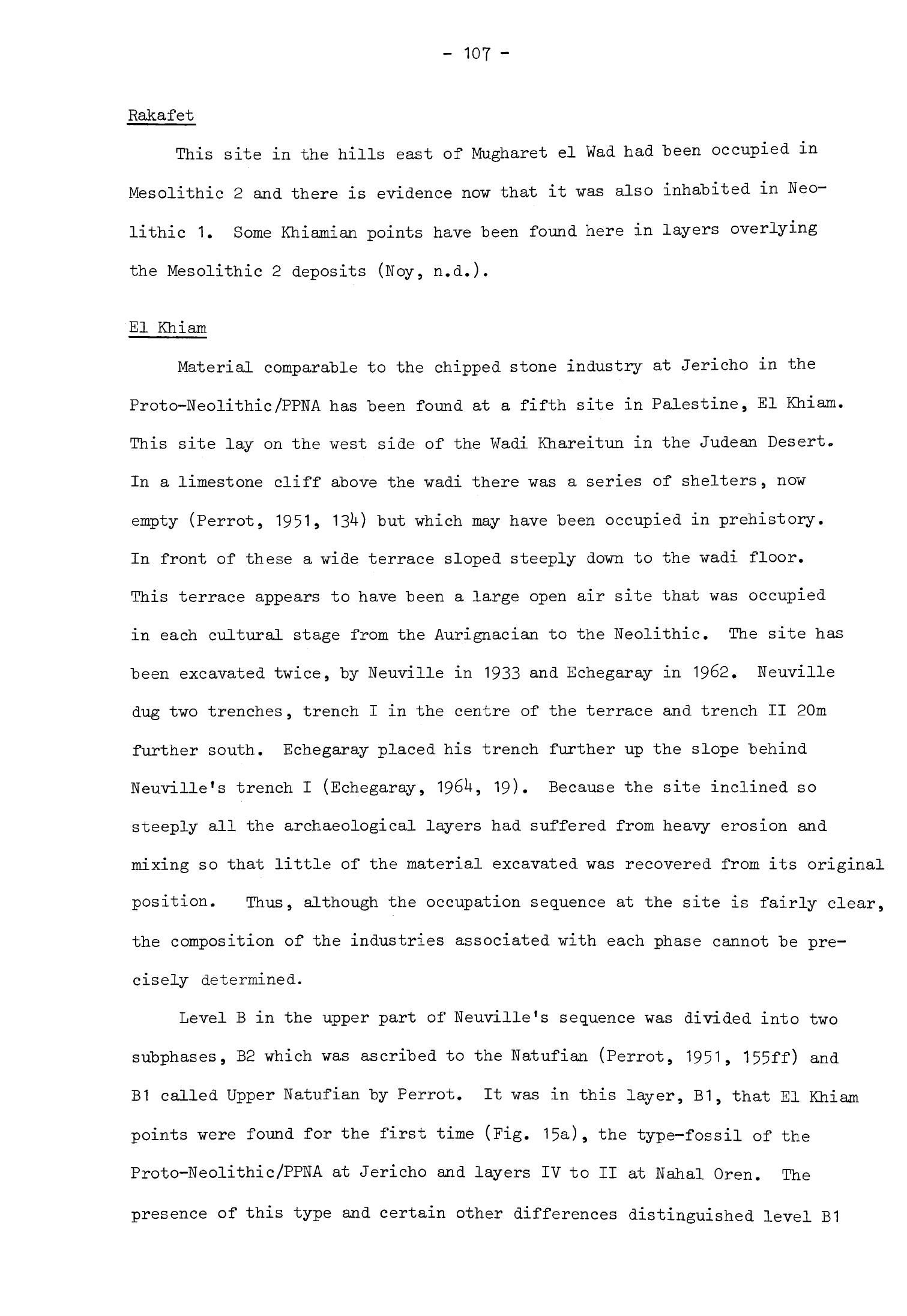
-
107
-
Rakafet
This
site
in
the
hills
east
of Mugharet
el
Wad
had
been
occupied
in
Mesolithic
2
and
there
is
evidence
now
that
it
was
also
inhabited
in
Neo-
lithic
1.
Some
Khiamian
points
have
been
found
here
in
layers
overlying
the
Mesolithic
2
deposits
(Noy,
n.d.).
El
Khiam
Material
comparable
to the
chipped
stone
industry
at
Jericho
in
the
Proto-Neolithic/PPNA
has
been
found
at
a
fifth
site
in
Palestine,
El
Khiam.
This site
lay
on
the west
side
of
the
Wadi
Khareitun
in
the
Judean
Desert.
In
a
limestone
cliff
above
the
wadi
there
was
a
series of
shelters,
now
empty
(Perrot,
1951,
13*0
but
which
may
have
been
occupied
in
prehistory.
In
front
of
these
a
wide
terrace
sloped steeply
down
to
the
wadi
floor.
This
terrace
appears
to
have
been
a
large
open
air
site
that
was
occupied
in
each
cultural
stage
from
the
Aurignacian
to
the
Neolithic.
The
site
has
been
excavated
twice,
by
Neuville
in
1933
and
Echegaray
in
19&2.
Neuville
dug
two trenches,
trench
I
in
the centre
of
the
terrace
and
trench
II
20m
further
south.
Echegaray
placed
his
trench further
up
the
slope
behind
Neuville's
trench
I
(Echegaray,
196U,
19).
Because
the
site
inclined
so
steeply
all the
archaeological
layers
had
suffered from
heavy
erosion
and
mixing
so
that
little
of
the
material
excavated
was
recovered
from
its
original
position.
Thus,
although
the
occupation
sequence
at
the
site
is
fairly
clear,
the
composition
of
the
industries
associated
with
each
phase
cannot
be
pre-
cisely
determined.
Level
B
in
the
upper
part
of
Neuville's
sequence
was
divided
into
two
subphases,
B2
which
was
ascribed
to
the
Natufian
(Perrot,
1951,
155ff)
and
B1
called
Upper
Natufian
by
Perrot.
It
was
in
this
layer,
B1,
that El
Khiam
points
were
found
for
the
first
time
(Fig.
15a),
the
type-fossil
of
the
Proto-Neolithic/PPNA
at
Jericho
and
layers
IV to
II
at
Nahal
Oren.
The
presence
of
this
type
and
certain
other
differences
distinguished
level
B1
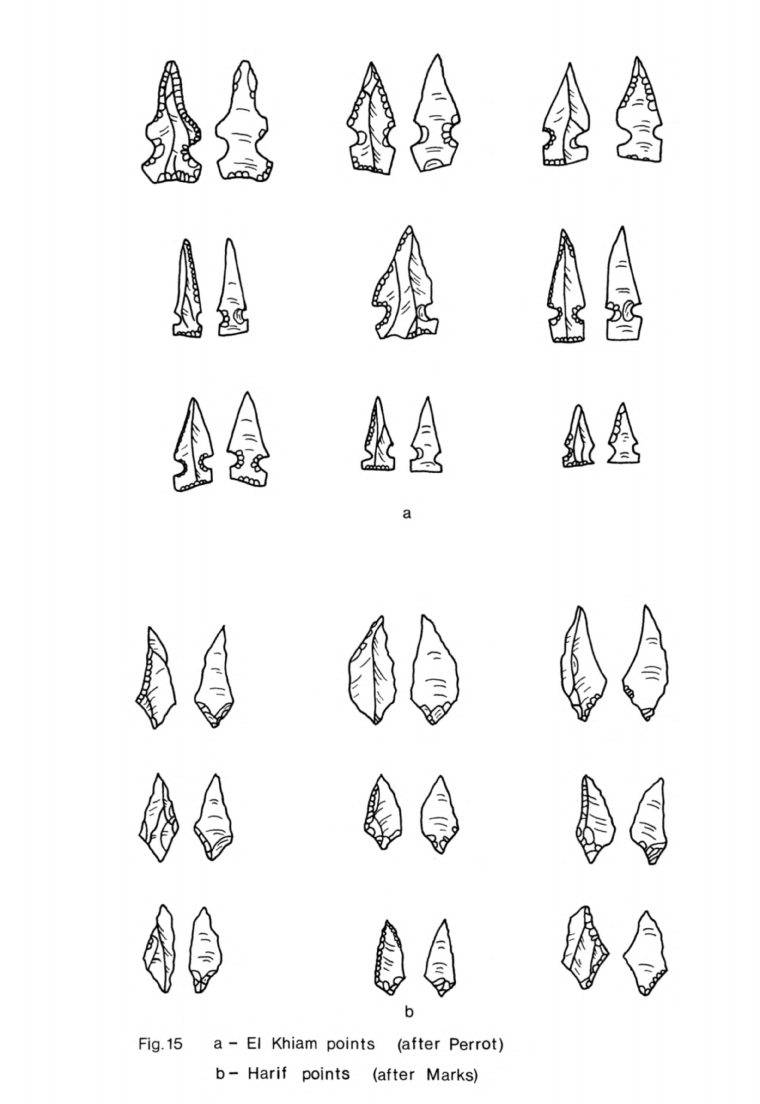
Fig.
15
a
-
El
Khiam
points
(after
Perrot)
b-
Harif
points
(after
Marks)
-
108
-
from
the
Natufian
B2
and
also
from
levels
A3
and
A2
above.
The
industry
in
the
latter
layers
had
much
in
common
with
PPNB
levels
at
Jericho
and
levels
6
to
3
at
Munhatta.
If
one
compares
the
stratigraphy
and
typology
of
the
assemblages
in
these
levels
with
Echegaray
!
s
more
detailed
sequence
then
Neuville's
B2
is
the
same
as
levels
7
(Kebaran
II)
and
6
(Kebaran
III).
Levels
8
(Kebaran
I)
and
5
(Khiamian
I)
also
had
a
number
of lunates and
other
microliths
which
suggest
that
they
were principally
composed
of
Natufian
remains.
True El
Khiam
points
did not
occur
until
level
U
(Khiamian
II)
in
Echegaray's
sequence
(1966,
^9ff)
although
certain
heavy
tools
such
as
stone
axes
which
might more
properly
belong
with
this
industry
were
found
in
level
5
(Echegaray,
1966,
^7)
;
each
level
contained
material
derived from
other
phases
as is
only
to
be
expected
in
a
site
where
much
soil
movement
had
taken
place.
Levels
h
and
3
(Prototahunian)
appear
to
correspond
to
Neuville's
B1
and
levels
2
(Prototahunian)
and
1
(Tahunian)
to
Neuville's
A,
1
to
3.
The
assemblage
in
levels
h-
and
3
included
a
number
of
burins
and
scrapers
as
well
as
many
retouched
blades,
rather
more
than
Neuville
found
apparently
(Perrot,
1951>
165).
These
discrepancies
can
partly
be
explained
by
the
idiosyncratic
typing
practised
by
Echegaray.
There
were
also
lunates,
backed
and
truncated
bladelets,
microburins
and
in
level
3
a
few
tanged
arrowheads
with
squamous
retouch
and
some
large
blades,
most
of
which
were
probably
intrusive
from
other
layers;
Neuville's
B1
contained
the
same
admixture.
This
makes
it
particularly
difficult
to
determine
the
principal
characteristics
of
the
industry
in
these
levels
so
that
one can
do
no
more than
point
to
a
general
similarity
with
the
industries
in
Proto-Neolithic/PPNA
Jericho
and
Nahal
Oren IV
to
II.
This
similarity
extended
to
the
use of
pestles,
other
grinders,
mortars,
stone
bowls,
all of
which
occurred
in
level
h
(Echegaray,
1966,
60)
and
which
were
abundant
in
Neuville's
trenches
(Perrot,
1951,
136);
there
was also
a
clay
anthropo-
morphic
figurine
from
this
level.
Bone
tools
do
not
appear
to
have
been
recovered
in
either
excavation.
-
109
-
Gilgal
Another
Neolithic
1
site
in
the
Jordan
valley
has
recently
"been
discovered
and
partly
excavated.
This
is
Gilgal
situated
20km
north
of
Jericho.
A
dozen
elliptical
huts
were
identified
here,
one
of
which
has
been
dug
(Noy,
19T6a)
,
U8).
The
flints
in
and
around
the
excavated
hut
included
burins,
borers
and
scrapers
as
well
as
Khiamian
points and
notched
arrowheads. Some
bone
tools
were
also
found.
Among
the
coarser
artifacts
were
basalt
tools
and
some
polished
limestone
axes
like those
from
Jericho.
Poleg
18M
Another
site
which
may
have
been
occupied
at
this
time
is
Poleg
18M.
The
surface
material
from
this
site
had
Mesolithic
2
affinities
but
there
were
at
least
two
points
with
side
notches
and
basal
retouch
(Burian,
Friedmann,
1963-6U,
11)
which
on
stratified
sites
have
been
found
in
early
post-Mesolithic
2
contexts.
Some of
the
other
tools
such
as
the
burins,
scrapers
and sickle
blades
could
equally
well
have
occurred
on
an
early
Neolithic
site. It
is
possible,
therefore,
that
this site
was
occupied
briefly
in
Neolithic
1.
All
these
sites
in
Palestine
had
occupation
deposits
with
a
similar
flint
industry
and
other
artifacts.
Where
buildings
were
preserved
these,
too,
were
found
to
be
of
a
similar
type.
On
the
stratified
sites,
Jericho,
Nahal
Oren
and
El
Khiam,
these
were
also
the
earliest
post-Mesolithic
2
remains.
It
is
for
these
reasons
that
I
believe
all
these
sites
belong
within
the
first
stage
of
the
Neolithic
in
the
Levant,
Neolithic
1.
Beidha
The
discovery
at
Beidha
of
Neolithic
occupation
layers
stratified
between
Mesolithic
2
remains
and
the
7th
millennium
B.C.
village
of
stone-
built
houses
raises
the
possibility
that
the
.site
was
occupied
contemporaneous
ly
with
PPNA
Jericho
and
Nahal
Oren
layers
IV
- II
by
people
with
similar
material
culture.
The
earliest
occuDation
at
TteirHna.
rh'Rr>nwr^ri
an
-
110
-
consisted
of
a
settlement
with
an
associated
Mesolithic
2
flint
industry
designated
as
layer
X
(Mortensen,
1970a,
h).
Soundings
made
in
the
first
two
seasons
on
the
eroded
steep
western
slope
of
the
site
revealed
0.5
to
0.75m
depth
of sandy
deposit
with
a
hearth,
stone
slabs,
a
stone-lined
pit
and
many
animal
bones
(Kirkbride,
1960b,
1^1).
In
later
work
more
Mesolithic
2
occupation
was
found
in
squares
lA
and MU
on
the
southern
side of
the
site
under
House
XVIII
of
layer
VI;
this
consisted
of
part
of
a
structure
of
mud-bricks
and
plaster
(Kirkbride,
1967,
10).
Towards
the centre
of
the
site
in
a
sounding
beside
House
XXXVII
there
was
more
Mesolithic
2
occupation
with
a
wall
1m
high
built
of
the
same
sandy
irregular
mud-bricks
on a
curved
stone
foundation.
These
and
other soundings
established
that
the
Mesolithic
2
occupation
was
up
to
2.5m
deep
and
extended
under
the
southern
half
of
the
Neolithic
village
(Kirkbride,
1967,
12).
This
Mesolithic
2
settlement
was
overlain
by
between
2
and
3m
of
virtually
sterile
windblown
sand
(Kirkbride,
1960b,
1^1;
1966,
hj),
except
in
squares
Lh
and
MU
where
House
XVIII
was
built
directly
on
top
of
the
Mesolithic
2
layers.
The
sand
was
not
sterile
everywhere:
in
another
sounding
in
the
centre
of
the site
a
stone
was
found
which
had
been
deliberately
set
upright
with
clay
and
pebbles
(Kirkbride,
1968,
92).
Apart
from
this
slight
trace
of
human
activity
the
site
appears
to
have
been
deserted
while
the
sand
accumulated
(Kirkbride,
1967,
12).
Above
this
thick
layer
of
sand
lay
several
levels of
occupation,
Levels
IX
-
VII
(Mortensen,
1970a,
U),
with
no
trace
of
substantial
structures.
These
levels
consisted
of
a
sandy
deposit
with
layers
of
human occupation
within
it
and
some
associated
features.
A
deposit
of this
nature
was
found
in
squares
HU
and
H5
near
the
middle
of
the
site
(Kirkbride,
1967,
5ff)
;
this
was
Level
VIII.
There
was
a
similar
deposit
with
a
small
hearth
in
squares
EU,
E5
and
E6
beneath
the
houses
of
the
later
village.
In
the
same
squares
two large
floors
were
found
side
by
side on
top
of
the
sandy
occupa-
tion
layers.
These
floors,
described
as
level
VII,
were
made
of
a
mixture
-
111
-
of
sand
and calcareous
clay
resembling
plaster;
one
of
them had
three post-
holes
in
it.
Many
more
of
these
firm
floors
were
found
during
the
last
season's
digging
in
squares
Gk
,
Eh
and
Jh
in
the
middle
of
the
site
(Kirkbride,
1968,
92)
stratified
beneath
Level
VI
and
so
presumably ascribed
to levels
IX,
VIII
and
VII.
Post-holes,
some
with
stone
packing,
were
associated
with
some of
these
floors.
There
were
also
many
hearths
hollowed
out
in
the
floors,
one
of
which
was
surrounded
by
clay
lumps.
Traces
of
two
squared
timber
beams
were
noted
in
one
layer
and
the
outline
of
a
large
wooden
platter
or
basket
in
another.
Apart
from
these
finds
the
floors
were
fairly
clean
so
that
few
artifacts
or
animal
bones
were
recovered.
These
floors
were
stratified
directly
beneath
a
series of
courtyards
belonging
to
the
later
village
which
were
also
quite
clean.
As
no
break
in
the
occupation sequence
is
suspected
and
as
there
was
some
continuity
of
internal settlement
arrangements
at
Beidha
it
may
be
that
these
floors
were
also open
yards
and
that
houses
built
of
wood
and
clay,
if
not
stone,
lay
beyond
them
in
the
unexcavated
areas.
These
surfaces
seem
to have
represented
living
floors
in
which
some
domestic
activities
were
carried
out
and
where
several
slight
wooden
structures
were
built.
Because
they were
regularly
replaced
the site
must
have
been
repeated-
ly
occupied,
either
continuously
or
on
a
seasonal
basis.
None
of
the
artifacts
from
these
levels
at
Beidha
has
been
published
so
that
it
is
not
possible
yet
to
say
whether
the
flint
industry
was
like that
of
Neolithic
1
sites
in
Palestine
or
not.
All we
do
know
is
that
there
were
very
few
artifacts
in
Levels
IX
-
VII,
that
the
flint
industry
was
Neolithic
in
aspect
(Kirkbride,
1967,
6)
and
that
there
was
no
break
in
the
tradition
of
flint
working
between
Levels
IX
-
VII
and
the
later
levels (Mortensen,
19TOa,
13).
The
flint
industry
from
Levels
VI
-
I
at
Beidha
has
been
described
as
resembling
the
PPNB
industry
at
Jericho
and
elsewhere
(Mortensen,
1970a,
51),
although there
were
in
fact some
significant
differences
between
them.
Two
of
the
arrowhead
types,
A1
and
A2,
found
in
these
layers
had
a
distinctly
archaic
look.
They
both
had
a
pair
of
side
notches
and
a
straight
snapped
-
112
-
or
rounded
retouched
base
(Mortensen,
1970a,
22).
Type
A1
was
almost
a
Khiamian
point (especially
Mortensen,
19TOa,
fig.
12,
c)
which
could
be
paralleled
at
Jericho
in
the
PPNA
and
in
the
contemporary
levels
at
El
Khiam
while
type
A2
was
found
in
"both
the
Proto-Neolithic
and
PPNA
at
Jericho
(Kirkbride,
1960a,
pi.
XIII
A:
0,P,R,S).
As
these types
are
characteristic
of
an
earlier
phase
when
they
are
found
stratified
on
other
sites
their
presence,
even
in
small
quantities,
in
Levels
VI
to
I
at
Beidha
merits
comment.
Either
they were
definitely
contemporary
with
the
rest
of
the
material
in
the
layers
in
which
they
were
found
and
so
late
examples
of
a
type
which
had
ceased
to
be
made
elsewhere
or
they
were
secondary.
Mortensen
has
pointed
out
(19TOa,
h6)
that
the
lower
levels
of
the site
were
disturbed
by
later
building
and that
material
from
these
levels
was
consequently
found
higher
up.
It
is
possible,
therefore,
that
these
arrowheads
and
no
doubt
some
of
the
other
material
in
levels
VI
-
I
such
as
the
burins and
scrapers
were
derived from
an
earlier
assemblage
in
levels
IX
-
VII
that
had
some of
the
characteristics,
at
least,
of
the
PPNA
at
Jericho.
No
ll
*C
determinations
have
been
made
on
material from
levels
IX
-
VTI
but
there
are
no
less
than
seven
dates
now
for
level
VT.
These
have
a
wide
range
from
6990
±
160
B.C.
K-1086
to
6596
±
100
B.C.
P-1379
(Mortensen,
19TOa,
13),
making
it
difficult
to
estimate
when
the
first
occupation
in
this
layer
took
place;
all the
determinations
for
the
later
layers
except
one
fall
within
the
same
time
range
and
the
exception,
P-1380
from
level
IV,
is
in
fact
earlier.
From
these
determinations
one
might
suggest
with
due
caution
that level
VI
began
about
7000
B.C.
which
would
mean
that
the
occupation
represented
by
layers IX
-
VII
took
place
in
the
later
8th
millennium
B.C.
This
would
make
these
levels
contemporary
with
the
PPNA
at
Jericho. Thus
from
levels
IX
to VII
we
have
evidence
of
an
8th
millennium
settlement
occupied
regularly
over
many
years;
it
also
seems
likely
that
the
associated
material
culture
had
some
elements
in
common
with
Neolithic
1
at
Jericho
and
Nahal
Oren.
Apart
from
the
indications
of
floors,
hearths
and
some
wooden
-
113
-
structures
the true
nature
and
extent
of
this
settlement
have
not
yet
been
established
"because
of
the
limited
area
of the
soundings
from
which
the
evidence
was
derived.
Harifian
sites
All
the
sites
discussed
so
far
with
the
exception
of
Beidha
were
situated
in
central
Palestine,
"but
another
group
of
sites
with
a
post-
Mesolithic
2
industry
has
recently
"been
found
in
the
Negev
and
northern
Sinai.
The
type-site
is
Abu
Salem
(G12)
on
the
Har
Harif
plateau
and
there
are
two
other
sites,
G8
and
K3,
with
similar
remains
less
than
2
km
away
(Marks
et
al.
,
1972,
8lff).
The
Har Harif
plateau
is
the
highest
area
in
the
Negev
and
these
sites
are
all
at
an
elevation
of
nearly
1000
m.
G8,
which
was
about
3000
sq_
m
in
area
had
been
almost
entirely
deflated.
K3
had
a
thin scatter
of
artifacts
extending
over
8000
sq
m
but
it
is
believed
that
this
was
the
result
of
considerable
surface
movement
of
material
since
the
site
was
abandoned
and
that
originally
the
occupied
area
would
have
been
much
smaller.
This
site
had
a
number
of
bedrock
mortars.
Artifacts
at
Abu
Salem
were
spread
over
2500
sq
m
but
it
is
believed
that this
was again
partly
due
to
natural
slope
wash
and
that
occupation
was
confined
to
1600
sq
m
of
the
present
site.
Abu
Salem
had
some
occupation
deposit
in
situ,
23^
sq
m
of
which
has
been
excavated
(Marks,
Scott,
1976,
^7)
The
site
consisted
of
a
series
of
circular
and
oval
stone-walled
struc-
tures,
the
larger
ones
being
from
3
to
h
m
and
the
smaller
from
1
to
2
m
in
diameter. The
larger
structures
were
presumably
dwellings
but
the
smaller
ones
probably
served
another
purpose.
Stone
grinders
were
found
in
the
excavation
as
well
as
slabs
with
cup-marks
in
them,
several of
which
were
stained
with
ochre.
There
were
also
nine
bone
points,
dentalium
and
a
variety
of
other
marine
shells
from
the
Mediterranean
and
Red
Sea.
In
contrast
with
this
sparse
inventory
of artifacts the
chipped
stone
industry
was
exception-
ally
abundant
(Marks,
Scott,
1976,
50).
The raw
material
was
principally
a
very
fine-grained,
translucent
flint
much
used
on
Mesolithic
2
sites
in
the

area,
although
some
of
the
larger
tools
were
made
on
medium
and
coarse-grained
opaque
flint.
The
industry
was
microlithic
with
tools
being
made
on
small
flakes
and
blades
struck
from
prismatic
and
pyramidal
cores.
Microliths
comprised
hO%
of
the
flint
artifacts.
Many
of
these
were
lunates
with
abrupt
backing,
the
remainder
being
triangles
and
trapezes.
The
type-fossil
of
the
industry
was
the
Harif
point
which
comprised 8.^$
of
the
tools.
Harif
points
(Marks,
1973,
97ff)
are
diamond-shaped
obliquely
truncated
blades
with
a
stemmed
base
(Fig.
15b).
The
base
is
often
prepared
by
the
microburin
technique
and
microburins
are
a
common
by-product
of
the
Abu
Salem
industry.
Harif
points
are
very
varied
in
shape
and
finish
but
all
are
quite
small,
usually
between
1.75
cm
and
3
cm
in
length,
and
so
may
be
counted
as
micro-
liths.
The
function
of
Harif points
is
uncertain
but
it
may
be
that
they
were
used
to
arm
arrows
as
Khiamian
points
are
presumed
to
have
been.
The
other
main
classes
of
tools
at
Abu
Salem
were
scrapers
(10.7%),
usually
end-scrapers
on
flakes,
notched
(12.2$)
and
truncated
(Q.k%}
pieces,
a
wide
variety
of
small
backed
blades
(20.8$),
notched
pieces
(12.2$)
and
a
few
nibbled
pieces.
Burins
(0.7$)
and
sickle
blades
(0.2$)
were
very
rare.
Three
samples
from
Abu
Salem
have
now
been
dated,
all
from
rubbish
pits
excavated
in
the
settlement.
One
from
a
depth
of
15
to
20
cm
has
given
a
date
of
8020
±
150
B.C.
1-5^98
and
another
from
25
to
30
cm
8280
±
150
B.C.
1-5^99:
a
third
sample
from
50
to
55
cm
in
depth
has
the
same
laboratory
number
and
has been
given
the
same
date
(Marks,
Scott,
1976,
U7).
These
determinations
are
mutually
consistent
and
indicate
that
the
site
was
occupied
towards
the
end
of
the
9th
millennium,
perhaps
between
8300
and
8000
B.C.
Several
more
Harifian
sites
have
been
found
in
recent
surveys
north
of
the
Har
Harif
and
in
Sinai.
One
site
is
HL
110
near
Nahal
Lavan
(Bar-Yosef
et
al.,
197^,
10ff)
in
the
southern
part
of
the
Halutza
sand
dunes.
Harif
points
made
up
5^$
of
the
total
number
of
tools
at
this
site
and
microburins
were
quite
common.
Some
related
flints
have
been
found
at
another
site
in
Nahal
Lavan,
Nahal
Lavan
108,
north-west
of
NL
110.
These
were
triangles
•with
straieht
Or
concave
retouched
bases
and
sidp
nnt.ph^s
(i\Trw
n
A
-^i
c^
-
115
-
They
would
appear
to
be
variants
of
Khiamian
points
so
the site
may
have
been
contemporary
with
Harifian
sites
in
the
same
area.
Several
more
Harifian
sites
have
been
found
in
recent
surveys
north
of
the
Har
Harif
and
in
Sinai.
One
site
is
NL
110
near
Nahal Lavan
(Bar-Yosef
et
al.,
197^,
10ff)
in the
southern
part of
the
Halutza
sand
dunes.
Harif
points
made
up
^\%
of
the
total
number
of
tools
at
this
site
and
microburins
were
quite
common.
Some
related
flints
have
been
found
at
another
site
in
Nahal
Lavan, Hahal
Lavan
108,
north-west
of
NL
110.
These
are
triangles
with
straight
or
concave
retouched
bases
and
side
notches
(Noy,
n.d.,
pi.
S).
They
would
appear
to
be
variants
of
Khiamian
points
so
the
site
may
have
been
contemporary
with
Harifian
sites
in
the
same
area.
A
few
Harif
points
have
been
found
on
three
other
sites
in
the
Halutza
dunes
(Bar-Yosef
et
al.,
197^,
78).
One of
these,
site
87,
which
is
at
the
northern
end
of
the
dunes
near
Nahal
Besor
(Burian,
Friedmann,
1973,
figs.
1,
2)
also
had
material
from
a
later
phase
of
the
Neolithic.
A
fourth
site
with
Harif
points
in
this
district
has
recently
been
reported,
Halutza
dunes
h
(Noy,
n.d.).
Two more
Harifian
sites
have
been discovered
in
the
Jebel
Meghara
in
northern
Sinai
(Phillips
et
al.,
n.d.,
9)
9
one,
site
LIV,
in
the
Wadi
el
Masagid
and
another,
M
III,
in
the Wadi
el
Moshabi.
The
material
from
L
IV
and
M
III
was
collected
carefully
so
that
it
would
be
a
representative
sample
of
the
assemblages
at
these
sites;
it
can
therefore
be
compared directly
with
the
material
from
Abu
Salem.
The
assemblages
from
L
IV
and
M
III
included
a
number of
Harif
points
and
plentiful
evidence of
the use
of
the
microburin
technique;
truncated
pieces
were
also
very
common
although
burins
were
rare.
These
features
are
characteristic
of the flint
industry
at
Abu
Salem
but
the
collections
from
L
IV
and
M
III
differed
from
Abu
Salem
in
other
respects.
Lunates
and
other
geometries,
backed
pieces and
end-scrapers
were
all
rare
at
L
IV
and
M
III
in
contrast
with
Abu
Salem.
It
would
thus
appear
that there
is
considerable
variability
in
the
flint
assemblages
from
one
Harifian
site
to
another.
- 116 -
The
structures
and
chipped
stone
industry
at
Abu
Salem
and
other
Harifian
sites
had
much
in
common
with
Mesolithic
2
in
the
Negev
at
sites
such
as
Rosh
Zin and
Rosh
Horesha.
The
sub-circular
structures
at
Abu
Salem
and
the
bedrock
mortars
at
site
K3
were
very
like
those
at
Rosh
Zin
(Henry,
1973a,
206).
The
Harifian
and
Negev
Mesolithic
2
flint
industries
were
based
on the
production
of
small
tools
from
prismatic
and
pyramidal
cores. In
both
microliths,
particularly
lunates,
usually
predominated
and
microburins
were
a
common
by-product.
Of
the
other
tool
types
end-scrapers
on
flakes
and
notched
pieces
were
often
numerous
in
both
industries.
These
similarities
are
sufficiently
comprehensive
to
suggest
that
the
Harifian
was
derived
from
Mesolithic
2
in
the
Negev
although
there
are
quite
significant
differences
between
the
artifacts
of
these
two
complexes.
Burins,
for
instance,
were
rare
at
Abu
Salem,
L
IV
and
M
III,
though
common
at
Rosh
Zin and
Rosh
Horesha,
and
the
Harif
point
was
of course
an
innovation
found
in
quantity
only
on
Harifian
sites.
One
Harif
point
was
found
at
Rosh
Horesha
which,
taken
together
with
other
traits
in
the
industry
and the
llt
C
dates
from
there,
suggests
that
this
site
may
have
been
occupied
towards
the
end
of
Mesolithic
2
in
the Negev.
The
Harifian
complex
also
has some
features
in
common
with
Neolithic
1
at
Jericho
and
Nahal
Oren.
The
structures
at
Abu
Salem
for
instance
resembled
those
at
Nahal
Oren.
The
flint
industries
shared
the
same
core
technique
and
small
size
of
tools
while
scrapers
and
retouched
blades
were
major
tool
types
common
to both.
Sickle
blades
were
rare
in
both
industries.
The
Harif
point
may
be
taken
to
be
the
Harifian
equivalent
of the
Khiamian
point
although
it
was
much
more numerous
on
Harifian
sites
than
Khiamian
points
seem
to
have
been
further
north.
Harif
points
are
known
to
occur
in
quantity
only
on
sites
in
the
Negev
and
Sinai
but
they have
been
found
in
small
numbers
elsewhere.
They
occurred
at
El
Khiam
(Perrot,
1952;
fig.
2,
21),
in
a
variant
form
and
in a
later
context
at
Beidha
as
arrowhead
type
A8
(Mortensen
1970a,
23),
and
even
at
Mureybat
in
phase
IB
(Cauvin,
197Ub,
n.
23).
The
-
117
-
type
is
so
variable
in
morphology
that
it
can
resemble
artifacts
classed
as
tanged
points
elsewhere
so
these
occurrences
need
not
be
very significant.
They
do
lend
a
little
weight,
however,
to
the
argument
outlined
above
for
equivalence
between
the
Harifian
and
Neolithic
1
industries
in
Palestine.
Although
the
resemblances
between
the
Harifian
and
the
Proto-Neolithic/
PPNA
include
structures,
flint
tool
production
and even
certain
tool type
proportions,
there
are
still
differences
between
the
flint
industries.
The
Harifian
had
far
more
microliths,
particularly
lunates
and
microburins,
than
the
northern
sites
while
borers
and
flaked
axes
appear
to
be
absent;
one
also
notes
that
obsidian
is
not
found
on
Harifian
sites,
although
this
may
be
simply
due to
the
greater
distance
of
the
sites
from
the
Anatolian
sources
and
the
fact
that
obsidian
exchange
was
only
just
beginning.
The
Harifian
and
Neolithic
1
in
Palestine
appear
to
have
been
contempora-
neous
and
the
distribution
of
sites
of each
group
is
mutually
exclusive.
They
both
developed
from
Mesolithic
2
in
their
respective
areas
and
had
many
cultural
features
in
common.
This
suggests
that they
are
both
variations
of
the
same
cultural
complex,
that
is
the
first
post-Mesolithic
2
culture
in
the
southern
Levant.
The
similarities
in
the
material
remains
of
the
two
groups
would
also
indicate
that
their
inhabitants
were
living
in
much
the
same
way.
We
may
thus
include
Harifian
sites
within
Neolithic
1
of
the
Levant.
Nacharini
Few
sites
with
occupation
immediately
post-dating
the
Mesolithic
have
yet
been
found
in
the
Levant
north
of
Palestine.
Only
one
is
known
in
Lebanon,
Nacharini,
a
cave
site
in
the
Anti-Lebanon
Mountains
north-east
of
Baalbek.
This
site
lies
high
on
the
side
of
a
small
valley
at
an
elevation
of
about
2000m.
Its
position
today
is
remote
from
any
settlement
but
it
lies
near
one
of
the
tracks
across
the
mountains
from
Baalbek
to
Yabrud.
The
area
around
the
site
is
snow-covered
during
the
winter
rendering
the
site
uninhabitable
at
this
season.

-
118
-
Nacharini
is
being
excavated
by
H.B.
Schroeder
who
has
dug
one
sounding
to
bedrock
through
the
deposit
in
the
cave.
The
sequence of
occupation
extended
from
the
Palaeolithic
to
the
aceramic
Neolithic
and
it
appears that
the
site
was
used
intermittently
throughout
this
long
period.
There
was
one
Mesolithic
2
level
which
had
a
rich
chipped
stone
assemblage
indicating
quite
intensive
occupation.
The
assemblage
included many
microliths
of
which
lunates
were
the
dominant
type.
There
was one
other
tool
type
which
was
quite
dis-
tinctive
although
of
unknown
function,
a
short
blade
segment
retouched
at
both
ends
frequently
with
a
concave
truncation.
This
type
was
very
numerous
at
Nacharini
but
was
unknown
at
other
contemporary
sites.
Immediately
above
this
layer
was
another
with
an
industry
of
small
tools
of
somewhat
similar
characteristics.
There
were
fewer
microliths
now
but
still
many
of the
distinctive
truncated
bladelets.
An
innovation
was
a
point
on
a
thin
blade;
this
had
a
pair
of
side
notches and
a
straight
or
concave
truncated
base.
These
notched
points
were
like
Khiamian
points,
the
only
difference
being
that
the
Nacharini
examples
were
usually
longer
and
narrower
than
the
Palestinian
type.
This
assemblage
at
Nacharini
cannot
be
matched
exactly
anywhere
else
and
one
suspects
that
its
unique,
specialised
nature
has
much
to
do
with
the
unusual
position
of
the
site.
Nevertheless
there
are
several
observations
that
can
be
made
about
the
material
which
allow
us
to
place
it
in
the
Levantine
sequence.
In
the
first
place,
it
succeeded
a
Mesolithic
2
industry
which
in
all
probability
was
itself
broadly
contemporary
with
the
Natufian
in
Palestine
and
Mesolithic
2
at
Abu
Hureyra
and
Mureybat
in
northern
Syria.
Secondly,
this
assemblage
was
clearly
derived
from
and
owed
much
to
its
Mesolithic
2
predecessor
so
there
is
a
strong
indication
here
of
cultural
continuity.
This
assemblage
would
thus
appear
to
be
the
first
post-Mesolithic
2
complex
in
Lebanon
and
although
it
has
certain
unique
features
there
are
parallels
for
it
in
Palestine.
We
have
noted
there
the
continued
use
of
microliths,
principally
lunates,
in
diminished
numbers
in
the
post-Mesolithic
2
industries
-
119
-
as
at
Nacharini while
the
correspondence
"between
the
Nacharini
notched
point
and
Khiamian
points
is
so
close
that
it
is
reasonable
to
suppose
that
the
Nacharini
type was
the
equivalent
of
the
latter
at
least
in
the
Anti-Lebanon.
It
is
very
probable,
therefore
that
the
Nacharini
assemblage
was
contemporary
with
Neolithic
1
in
Palestine
even
if
for
the
moment
we
have
no
14
C
deter-
minations
from
the
site to
support
this
conclusion.
Mureybat
Mureybat
is
the
only
site
known
in
Syria
where occupation
continued
without
interruption
after
the
Mesolithic.
The
site
is
situated
on
the
left
bank
of
the
Euphrates
near
a
present-day
ford
and
ferry
crossing.
It
lies
on
a
consolidated
gravel terrace
which
is
itself
superimposed
on an
outcrop
of
soft
limestone.
The
site
faces
west
across
the
Euphrates
flood-plain
which
is
about
2.5
km
wide
at
this
point.
The
river
flows
at
its
foot
while
behind
to
the
east
the
land
gradually
rises
to
the
Jezireh
plateau.
The
site
today
forms
an
elongated
oval
platform
along
the
bank
of
the
river
and
rises
about
U
m
above
the
level
of
the
fields
behind.
The
core
of
the
site
is
a
small
circular
mound
6
m
high
which
lies
on
top
of
this
platform.
The
total
area
of
the
site
is
a
little over
3
ha
but
this
was
never
fully
occupied
in
any
phase
of
the
settlement's
existence. The
earlier
phases
of
settlement
were
concentrated
in
the
area
of
the
central
mound which
extends
over
^300
sq
m.
Mureybat
was
first
excavated
by
M.
van
Loon
who
in
196H
and
1965
dug
trenches
in
the
western
slope
of
the
central
mound
and
also
made
several
soundings elsewhere
on
the
platform. The
work
was
continued
by
J.
Cauvin
from
1971
to
197^4.
He
excavated
several
more trenches
a
little
to
the
south
of
van
Loon's
area
and
one
other
sounding
on
the
east
slope
of
the
central
mound.
These
excavations
have
shown
that
the
focus
of
occupation
altered
during
the
life
of the
settlement but
as
most
of
van
Loon's
and
Cauvin's
trenches
were
placed
quite
close
together
we
do
not
have
a
clear
idea
of
the
extent
of
each
phase
of
occupation.
The
full
sequence
of
occupation
on
the
-
120
-
site
has,
however,
now
"been
determined.
The
earliest
phase
of
settlement
was
found
"by
Cauvin and
designated
phase
I
(Cauvin,
1972,
107).
This
has
since
"been
subdivided
into
a
primary
phase
of
Mesolithic
occupation,
phase
IA,
and
a
post-Mesolithic
deposit,
phase
IB.
Phase
IA
appears
to have
been
confined
to
a
small
part
of
the
western
slope
of
the
central
mound,
covering
no
more than
100
or
200
sq
m,
and the
settlement
was
apparently
not
much larger
in
phase
IB.
The
phase
II
settlement
was
more
extensive,
covering
much
if
not
all
of
the
central mound;
this
phase
is
equivalent
to
strata
I
to IX
in
van
Loon's
excavation
(van
Loon,
1968,
267ff).
Phase
III,
van Loon's
strata
X
to
XVTI,
likewise
extended
over
much
of
the
central
mound.
The
deposits
of
phases
IB
to
III
are
the
remains
of
the
early
post-Mesolithic
settlement
with
which
the
excavations
at
Mureybat
have
"been
principally
concerned.
The
site
continued
to
"be
occupied
throughout
the
earlier
Neolithic,
apparently,
and
material
like
the
aceramic
Neolithic
at
Abu
Hureyra
and
Buqras levels
I
and
II
was
found
in
"both
campaigns
of
excavations;
the
llt
C
dates
for
these
levels
at
Buqras
indicate
that
this
phase,
designated
phase
IV
"by
Cauvin,
dates
from
the
7th
millennium
B.C.
The
earliest
buildings
at
Mureybat
were
found
in
phase
IB.
These
were
circular
structures
with
walls
made of
vertical
wooden
posts
set
close
together
(Cauvin,
1972,
107ff).
The
lower
50cm
of
the
walls
were
made
weatherproof
on
the inside
with
a
clay
facing
10cm
thick
which
were
the
only
parts
of
the
structures
that
survived.
Several
floor
surfaces
were
also
found
and
hearths
with
horseshoe-shaped
clay
surrounds.
Fire-pits
or
roasting
pits
filled
with
burned
pebbles
,
ash
and
charcoal
were associated
with
the
floors
and
were
a
feature
of
each
phase
of
occupation
at
Mureybat
from
phase
IA
to
phase
III.
The
chipped
stone
assemblage
from
this
phase
had
much
in
common
with
phase
IA.
Now
and
throughout
the
sequence
most
tools
were
made
on
small
blades and
flakes
struck from
prismatic
cores.
Microliths
comprised
7
to
20%
of
the
retouched
tools
in
these
levels.
Many
of
these
were
lunates
with

-
121
-
a
few
triangles
and
trapezes.
Microborers
were
also
very
common
while
a
few
backed
bladelets
made
up the
rest
of
the
microlithic
component.
Among
the
larger
tools
were
borers and
drills
with
a
few
end-scrapers,
burins,
denticu-
lates
and
occasional
sickle-blades.
There
were
two
new
tool
types
in
the
assemblage,
a
concave-based
arrowhead
with
side
notches
resembling
a
Khiamian
point
and
a
heavy
flaked
adze
(Fig.
16).
The
latter
was
probably
used
for
shaping
timber and
is
a
characteristic
tool
at
Mureybat
in
subsequent
phases.
The
remaining
artifacts
consisted
of
quite
abundant
bone
points
and
a
few
cylindrical
bone
beads.
In
phase
II
circular
structures
continued
to
be
built
but
these
were
somewhat
different
from
those
in
phase
IA.
These
were
now
usually
made
of
mud
and
stone
and
much
less
timber
was
used
in
their
construction. Most of
the
structures
were
about
k
m
in
diameter
but
some
were
as
small
as
2.7
m
across.
Their
floors
were
usually
made of
slabs
of
limestone
set
in
mud
and
sometimes
levelled
with
gravel
(van
Loon,
1968,
267).
The
walls
similarly
were
composed
of stones
set
in
mud
although
a
few
were
made
of
mud
alone
(Cauvin,
1972,
108)
,
presumably
with
some
support of
reeds
or
wood.
Querns
and
grinding
stones
were
frequently
incorporated
in
the floors
and
walls.
Although
little
more
than
the
floors
of
these
structures
survived,
their
size
and
frequency
suggest
that they
were
dwelling
huts.
Outside
these
buildings
were circular
fire-pits
about
80
cm
in
diameter
lined
with
clay.
They
were
full
of
ash,
charcoal
and
burned
pebbles.
These
may have
been
roasting
pits
for
meat
or
parching
seeds.
After
they
went
out
of
use
they were
frequently
filled
up
with
domestic
debris.
The
chipped
stone
industry
of
this
phase
was
significantly
different
from
phase
I
but
the
tools
were
still
small.
Microliths
were
still
very
common
but
these
consisted
almost
entirely
of
microborers
as
lunates
and
other
geometric
microliths
were
no
longer
used.
Of
the
larger
tools
drills
were
also
numerous
but
end-scrapers,
burins
and
sickle
blades
were
still
un-
common.
Arrowheads
were
now
much more
abundant.
Many
of
these
were
like
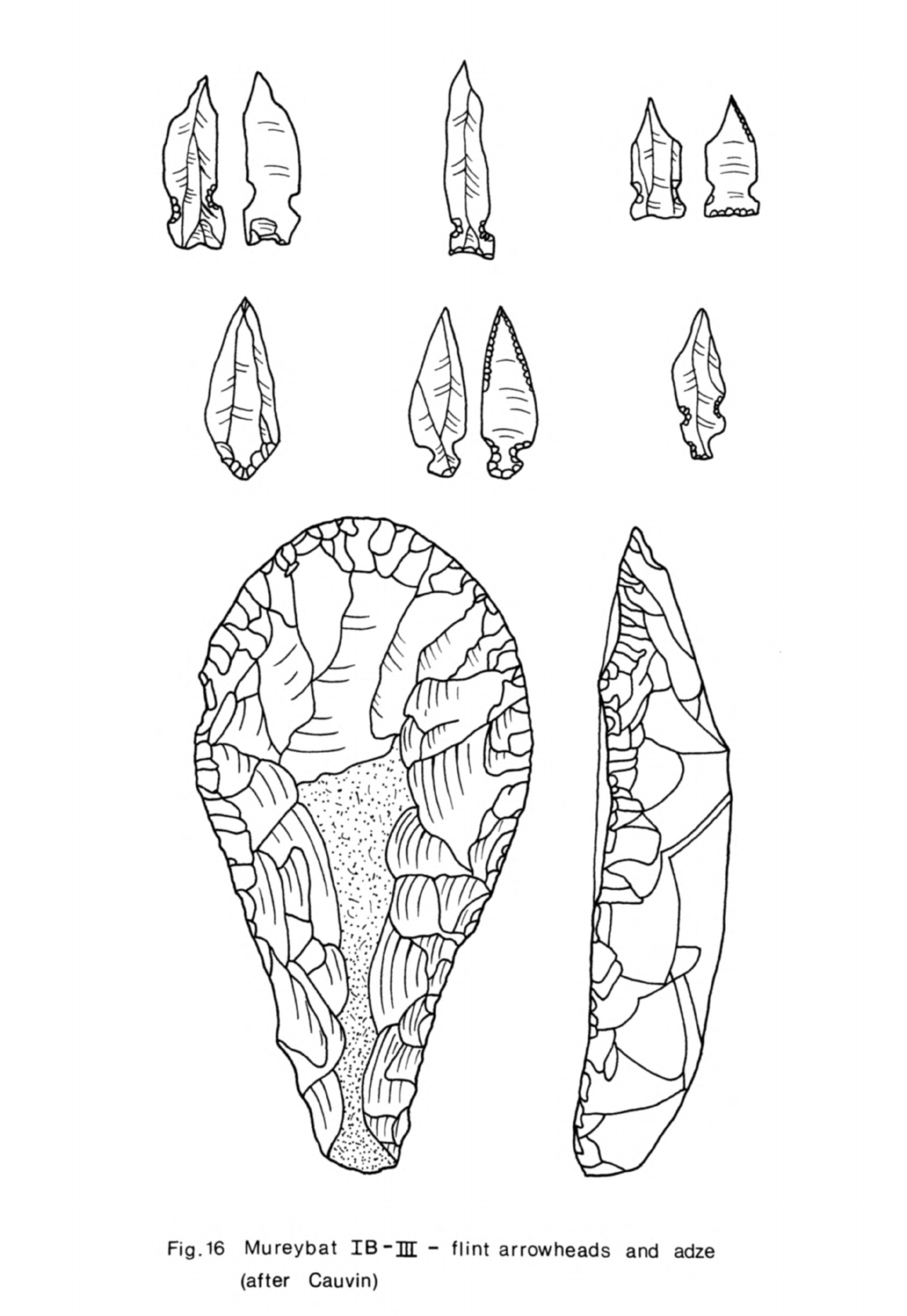
Fig.
16
Mureybat
IB-JH
-
flint
arrowheads
and
adze
(after
Cauvin)
-
122
-
Khiamian
points
(van
Loon,
1968,
pi.
IX,
g-k)
but
there was
much
variety
in
the
arrangement
of
the
notches.
A
few
now
had
a
stem.
Obsidian
was
found
in
small quantities
for
the
first
time
in
this
phase.
The
inventory
of
other
finds
was
a
little
more
abundant
and
varied
in
this
phase
than
earlier.
Bone
tools
such
as
borers
and
needles
were
particu-
larly
numerous
and
a
group
of
these
was
found
on
the
floor
of
Structure
1
(van
Loon,
1968,
268,
pi.
XIVB).
Cauvin
has
also
found
elaborate
combs
and
spatulae
with
serrated
ends
(1972,
figs.
3,
5).
Heavy
stone
tools
were
another
innovation
in
these
layers
though
querns,
grinders,
pestles
and mortars
are
known
from
the
Mesolithic
levels
at
Abu
Hureyra.
The
querns
were
oval
or
rectangular
in
shape
and
hollowed
out
in
the
centre
(van
Loon,
1968,
pi.
XIA).
Spherical
stones
appear
to
have
been
used
as
grinders
with
the
querns.
Pestles
and
mortars
were
also
quite
common.
One
or
two
anthropomorphic
stone
figurines
were
also
found
in
these
levels.
The
plans
of
the
buildings
changed
markedly
in
phase
III.
Some
were
still
circular
but
others
were
now
rectilinear
and
composed
of
several
rooms.
The
circular
structures
were
larger
than
before,
10
m
in
diameter
in
one
instance
(J.
Cauvin,
197^-a,
^6)
and
one
at
least
had
several
compartments
within
it.
The
walls
of
these
buildings,
like
the
rectilinear
ones,
were
now built with
rows
of
dressed
stones
held
together
with
mud.
Posts
and
split
logs
(van
Loon,
1968,
273)
were
used
to
strengthen
the
walls.
One
wall
was
decorated
with
several
rows
of
painted
black
chevrons
on a
white
back-
ground
(Cauvin,
1972,
110).
The
floors
were
frequently
paved
with
stones
as
in
phase
II.
The
structures
were
filled
with
much
burned
clay
which
retained
impressions
of
the
timber
and
straw
used
in
the
upper
part of
the
walls
and
roofs.
These
circular
buildings
were
found
in
Cauvin's
excavations
while
van
Loon
found
only
rectilinear
ones
(1968,
269ff). His
structures
were
built
in
the
same
way
as
the
circular
ones.
The
chambers
in
each
building
were
frequently
no
more
than
1.5
m
in
width.
None
of these chambers
had
a
doorway
at
floor level
so
they
must
have
been
entered
from
porthole
doors
higher
-
123
-
in
the
walls
or
from
at>ove.
Within
these
chambers
were
traces
of
separate
compartments,
possibly
storage
bins,
and
hearths.
These
buildings
are
complex
in
arrangement
and
consequently
difficult
to
interpret,
a
difficulty
compounded
by
their
poor
preservation.
The
circular
structures
are
commodious
enough
to
have
served
as
houses and
their
internal
compartments
may
have
fulfilled
a
domestic
function.
Most
of
the
rectilinear
buildings
as
they
survive
now
seem
far
too
cramped
inside
for
anything
more
than
storage.
It
is
possible,
of
course,
that
the
small
chambers
in
these
buildings
were
in fact
basement
storage
rooms
in
two-storeyed
structures
and
that
domestic
activities
were carried
out
on
the
first
floor.
There
is
a
paral-
lel for
this
arrangement
at
Ganj
Dareh
in
Iran.
Here
rectilinear
two-storeyed
buildings
built
in
this
same
way
with
walls
as
thin
as
those
at
Mureybat
have
survived
remarkably
intact
(P.E.L.
Smith,
1972,
166)
and
Smith
has
told
me
that
he
now
believes
the
basement
rooms
may
have
served
as
storage
chambers
for the
houses
above.
There
is
a
marked
resemblance
between
the
two
groups of
buildings
but
it
will
not
be
possible
to
state
with
certainty
what
the
function
of
the
Mureybat
buildings
was
until
we
know
more
about
their
precise
contents
.
The
earliest
occurrence
of
human
burials
within
the
settlement
at
Mureybat
was
in
phase
III.
The
inhabitants
of
the
settlement
in
earlier
phases
may
have
buried
their
dead
within
the
settlement but
outside
the
area
of
excavation.
Nevertheless
the
absence
of
burials
in
the
Mesolithic
deposit
at
Abu
Hureyra
strengthens
the
impression
one
has
that
in
northern
Syria
bodies
were
disposed
of
away
from
the
settlement
in
earlier
periods
in
contrast
with
the
Natufian
in
Palestine.
When
burial
within
the
settlement
was
introduced
in
phase
III
at
Mureybat
it
had
many
similarities
with
the
custom
at
Jericho
in
the
PPNA.
Skulls
were
detached
and
buried
in
groups
separated
from
the
corpses
to
which
they
belonged
(van
Loon,
1968,
275).
In
another instance
a
skull
and
several
long
bones
were
buried
together
without
the
rest
of
the
skeleton
(Cauvin,
1972,
110);
this
was
a
form
of
secondary
burial
that
was
a
regular
practice
in
a
later
context
in
the
aceramic
Neolithic
at
Abu
Hureyra.
The
flint
industry
was
modified
still
further
in
phase
III
though
it
was
still
in
the
same
tradition
as
that of
phases
I
and
II.
Apart
from
a
few
microborers
microliths
had
almost
disappeared.
In
their
place
the
larger
tools,
end-scrapers,
side-scrapers
and
burins
increased substantially
in
number
and
even
sickle
blades
were
more
abundant.
Arrowheads
were
also
much more
common
and
larger
too
(M.-C.
Cauvin,
197Ub,
n. 12).
Many
of
these
now
had
a
true
tang
for
hafting
as
well
as
side
notches
although
there
was
still
much
variety
of
shape;
Khiamian
points,
however,
had
all
but
disappeared
(M.-C.
Cauvin,
197^b,
31U).
A
few
of
these
arrowheads
were
retouched with
squamous
flaking
for
the
first
time
but
spare
abrupt
retouch
remained
the
usual
technique,
Obsidian
was
now
arriving
on
the
site
in
increasing
quantity.
Bone
tools
were
still
fairly
abundant;
the
most
common
ones
were
borers
as
before,
the
remainder
being
flat
spatulae
and beads.
None
of
the
elaborate
combs
has
been
found
in
these
levels but
even
in
phase
II
they
were
a
rare
find
and
so
perhaps
not
typical.
Among
other
finds
were
finely
made
stone
dishes
and bowls,
one
of
which
had
a
wavy
band
carved
in
relief
on
the
rim
(van
Loon,
1968,
273).
Querns,
grinders
and
other
heavy
stone
tools
were
very
common.
Then
there
were
a
few
other
pieces of
elaborately
carved
stone,
one
of
which
was
complete;
this
has
been
interpreted
as
an
anthropomorphic
figure
(Cauvin,
1972,
fig.
6)
but
it
would
appear
to
be more
like
an
owl
or
other
bird
of
prey.
Baked
clay
was
used
in
a
variety
of ways
for
the
first
time
in
this
phase.
Many
of
the
pieces
were
shapes
of
uncertain
design
but
a
few
were
quite
care-
fully
modelled
standing
female
figures
(J.
Cauvin,
197^a,
h6
,
50)
with
large
buttocks
and
hands
supporting
the
breasts.
Among
the
more
remarkable
objects
found
were
five
small
baked
clay
vessels
(j.
Cauvin,
197^b,
200).
These
were
little
cups,
bowls
and
dishes
from
k
to
7cm
in
diameter.
Such
finds
indicate
that
the
inhabitants
were
now
accustomed
to
making
a
variety
of
objects
in
baked
clay
but
that
the
substance
was
not yet
employed
for
utilitarian
objects
in
everyday
use.
-
125
-
More
lif
C
determinations
have
been
obtained
from
Mureybat
than
any
other
Neolithic
1
site
in
the
Levant
but
since
the
most
recent
dates
conflict
with
those
obtained
some
years
ago
the
precise
chronology
of
each
phase
is
by
no
means
certain.
I
discussed
some
of
these
determinations
in
Chapter
2
and
suggested
that
the
transition
from
phase
IA
to
IB
may
have
taken
place
about
8500
B.C.
The
duration
of
phase
IB
can
only
be
guessed
at
for
the
moment
since
the
single
determination
from
this
phase,
Lv-607,
cannot
be
reconciled
with
dates
obtained
for
phase
IA.
My
estimate
would
be
that
it
lasted
perhaps
200
years
and
that
phase
II
thus
began
about
8300
B.C.
Phase
II
is
no
better
dated
than
phase
I
since
two
of
the
Louvain
determinations
for
this
phase,
86^0
±
170
B.C.
Lv-605
and
8510
±
200
B.C.
Lv-606,
are
several
centuries
earlier
than
the
three
obtained
by
the
Philadelphia
laboratory,
8265
±
117
B.C.
P-1217,
81^2
±
118
B.C.
P-1216
and
8056
±
96
B.C.
P-1215.
One
other
Louvain
determina
tion
for
this
phase
should
be
mentioned,
7780
±
1^0
B.C.
Lv-6oU,
the
sample
for
which
came
from
near
the
surface
and
is
believed
to
have
been
contaminated
by
more
recent
humic
matter
(Gilot,
Cauvin,
1973,
38).
The
Philadelphia
dates
agree
better
with
the
more
recent
series
of
Monaco
determinations
for
phases
I
and
III
and
so
may
give
a
more
reliable
indication
of
the
duration
of
phase
II.
From
them
I
would
estimate
that
phase
II
was
concluded about
8000
B.C.
or
possibly
a
little
before.
Phase
III
is
dated
by
three
Philadelphia
determinations
from
the
first
series
of
excavations
and
eight
from
the
Monaco
laboratory
which
have
not
yet
been
fully
published.
These
two
series
are
reasonably
consistent
so
that
the
chronology
of
this
phase
appears
for
the
moment
to
be
better
established
than
that
of
phases
I
and
II.
The
Philadelphia
determinations
are:
8018
±
115
B.C.
P-1220
(levels
X-Xl),
75^2
±
122
B.C.
P-122U
(level
XVI)
and
795^
±
11U
B.C.
P-1222
(levels
XVI-XVII)
(Radiocarbon
11,
1969,
152).
The
earliest
of
the
Monaco
dates
is
8000
±
150
B.C.
Mc-73^
and
the
latest
7570
±
150
B.C.
Mc-612
(J.
Cauvin,
197^b,
200)
while
the others
fall
in
between.
Phase
III
thus
appears
to
have
lasted
from
about
8000
to
7500
B.C.
-
126
-
Circular
mud
"buildings
were
constructed
in
phase
IB
for
the
first
time
so
commencing
a
tradition
that
lasted
a
thousand
years
at
Mureybat.
The
earliest
modifications
to
the
Mesolithic
tool
kit also
occurred
in
phase
IB
with
the
introduction of
notched
points
and
flaked
adzes.
This
major
building
innovation
and
slight
but
significant
development
in
the
flint
industry
were
the
first
stage
of
a
gradual
but ultimately
thorough
cultural
change.
As
this
change
began
in
IB
it
seems
reasonable
to
take
this
phase
as
the
transition
between
Mesolithic
and
Neolithic.
The choice
is
somewhat
arbitrary,
however,
not
least
because
in
the
flint
industry
lunates
still
predominated
and
micro-
liths
as
a
group did
not
disappear until
phase
III.
The
development
of
the
flint
industry
illustrates
well
how
slow
but
far-
reaching
this
cultural
change
was.
First
there
was
the
change
in
the
micro-
lithic
component
dominated
by
lunates
at
the
beginning
and
then
by
microborers.
This
would
seem
to
indicate
that some
major
change
in
activities
within
the
settlement
was
taking
place
although
the
flint
technology
had
not
altered
much
at
this
stage.
Then
the
microliths
were
phased
out
and
the
tools
became
much
larger.
At
the
same
time there
was
a
change
in
the
core
technique
as
double-
ended
cores
were
now used
to
produce
blades.
Some
were
even
the
keeled
("naviforme")
cores
more
usually
associated
with
7th
millennium
and
later
industries
but
a
few
of
these
may
in
fact
have
belonged
with
the
phase
III
assemblage
rather
than
have been
intrusive
from
phase
IV.
Changes
in
the
typology
of
the
flint
tools
accompanied
these
technological
developments.
The
arrowheads
are the
best
example
of
this:
they
were
introduced
in
small
quantities
in
phase
IB
but
eventually
formed
as
much
as
25%
of
the
retouched
tools
in
certain
levels
in
phase
III (Cauvin,
1972,
110).
Their typology
also
changed
markedly
throughout
this
long
period
(M.-C.
Cauvin,
I97^b,
31*0.
These
changes
in
the
Mureybat
flint
industry
were
the
result
of
a
local
gradual
development
and
throughout
there
was
an
uninterrupted
continuity
of
culture.
Mureybat
is
the
only
site
known
in
the
Levant
at
present
where
a
microlithic
flint
industry
was
slowly
modified
until
it
became
a
blade-based
industry
typical
of
the
developed
Neolithic
and
where
no
-
127
-
"break
in
the
complete
sequence
is
suspected.
Such
a
gradual
development
of
the
flint
industry
indicates
that
the
population
remained
the
same,
that
the
Neolithic
inhabitants
were
the
descendants
of
their
Mesolithic
predecessors.
The
increasing
richness
and
variety
of
the
remainder
of
the
artifact
inventory
through
the
phases
also
suggests
that
the
inhabitants
were
"becoming
more
sedentary.
Tell
Aswad
One
other
site
with
deposits
dating
from
the
8th
millennium
B.C.
has
recently
"been
excavated
in
Syria.
This
is
Tell
Aswad
which
lies
in
the
Damascus
basin
about
25
km
south-east
of
the
city
and
about
half
way
between
the
present
Hijjane
and
Ataibe
lakes. In
this
region the
floor
of
the
basin
is
almost
flat
with
the
exception
of some
low
hills
a
few
metres
high.
Tell
Aswad
is
situated
on
one
of
these
which
originally
stood
about
2
m
above
the
level
of
the
plain.
Until
quite
recently
Tell
Aswad
lay
in
a
marshy
area
only
a
few
kilometres
from
the
edge
of the
lakes.
The
marshes and
lakes
would
have
been
even
more
exten-
sive
in
the
Neolithic
then
they
were
earlier
this
century.
The
site
is
almost
circular
and
very
extensive,
covering
about
5.^-1
ha,
although
the
occupation
deposits
are
only
from
2
to
3m
deep.
The
site
was
sounded
by
H.
de
Contenson
in
1971
and
1972.
He
excavated
two
trenches,
Aswad
East
and
Aswad
West,
each
k
m
square
and
spaced
wide
apart
in
the
southern
sector
of
the
site.
The
deposits
consisted
of
dark,
ashy
layers
with
traces
of
burned
vegetable
matter
and
charcoal
into
which
had
been
dug
many
pits
(de
Contenson,
1972,
76).
These
were
of
various
sizes
up
to
2
m
in
diameter.
Some
were
pit
hearths
full
of
burned
material,
others
were
rubbish
pits
but
none
was
large
enough
for
a
dwelling.
A
few
of
these
had
a
rim
of
plano-convex
mud-bricks
some
of
which
were
baked.
A
platform
of
bricks
was
found
in
the
East
trench
but
apart
from
this
there
were
no other
built
structures
in
the
trenches.
The
only
trace
of
building
activities
was
impressions
of
reeds
in
a
few
lumps
of
clay,
the
remains
perhaps
of
shelters
or
huts
built
by
the
inhabitants
out
of
materials
readily
available
in
the
locality.
The
surface
-
128
-
of
the
rest
of
the
mound
consisted
of
the
same
ashy
deposit
that
was
found
in
the
trenches
so
that
it
does
not
seem
that
there
were
structures
built
of
other
materials
such
as
mud-brick
elsewhere
on
the
site.
Several
burials
were
found
at
the
bottom
of
the
West
trench
(de
Contenson,
1972,
79).
Most
had
been
placed
at
intervals
in
a
single
pit dug
in
the
natural
subsoil.
There
was
one
complete
skeleton
in a
contracted
position,
another
that
was
incomplete
and
several
skulls
of
adults
and
children.
One
other
skull
was
found
set
on
the
natural
surface
in
the
same
trench.
The
flint
industry
at
Tell
Aswad
was
based
on
the
production
of
blades.
The
cores
were
prismatic
or
pyramidal
although
25%
of
them
were
bipolar,
a
few
being
of
the
keeled
type.
The
most
numerous
tools
were
sickle
blades and
tanged
arrowheads
(de
Contenson,
1972,
77)
while
the
remainder
consisted
of
notched
pieces,
burins,
borers
and
end-scrapers.
This
industry
was
more
developed
than
those
I
have
discussed
so
far
and
much
of
it
had
parallels
with
a
later
cultural
stage.
This
was
true also of
some
of
the
other
artifacts
found
at
Tell
Aswad
such
as
the
polished
axes
and
abundant
human
and animal
figurines.
Yet
at
least
some
of the
flint
tools,
the
notched
arrowheads
in
particular,
were
more
archaic.
This
impression
derived
from
typology
was
reinforced
by
the
ten
1If
C
determinations
made
on
samples
from
both
trenches
(de
Contenson,
1973a,
253ff).
All
of
these
from
the
West
trench
fell
within
the
7th
millennium
but
four
out
of
the
five
from
the
East
trench
were
from
the
8th
millennium.
De
Contenson
has
divided
the
sequence
at
Tell
Aswad
into
two
phases
based
upon
stratigraphy,
the
evolution
of
the
typology
of
the
flint
tools,
the
other
associated
artifacts
and
the
llf
C
dates.
The
site
is
now
believed
to
have
been
occupied
first
in
phase
I
and
the debris of
this
phase makes up
most of
the
deposit
of
Aswad
East.
The
earliest
date
here
is
7790
±
120
B.C.
GIF-2633
for
a
deposit
near
the
natural
surface
while
above
that
there
are
three
others
of
7690
±
120
B.C.
GIF-2372,
7390
±
120
B.C.
GIF-2370 and
7320
±
120
B.C.
GIF-2371.
.These
make
a
coherent
series
of
determinations
from
which
one
might
-
129 -
estimate
that
the
phase
began
a
little
before
7800 B.C. De
Contenson believes
that the
settlement
then
expanded
towards
the
west
for
some
material
of
late
phase
I
character
was
found
at
the
bottom
of
Aswad
West.
There
are
two
dates
for
this
of
6925
±
55
B.C.
GrN-6678
and
6915
±
60
B.C.
GrN-6679-
The
remainder
of the
deposit
in
Aswad
West
constitutes
phase
II.
A
little
material
of
this
phase,
dated
by
one
further
ll
*C
determination,
was
found
at
the
top
of
Aswad
East
suggesting
that
the
settlement
expanded
to
the
east
again
before
it
was
finally
abandoned.
Although
the
whole
of
the
site
may
have
been
occupied
at
least
briefly
in
phase
II
this
does
not
appear
to
have
been
so in
phase
I.
Then perhaps
no more than
half
or
even
less
was
occupied
at
any
one
time.
Even
this
would
have
been
a
considerable area
so
it
appears
that
Tell
Aswad
was
always
an
extensive
site
in
contrast
with
the
core
mound
at
Mureybat,
for
example,
which
was
much
smaller.
This
considerable
spread
of
settlement
may
be accounted
for
by
the
absence
of
permanent
structures
rather
than
simply
a
large
concentration
of
people.
The
inhabitants
may
have
preferred
to
spread
outwards
over
the
natural
hill
on
which
the
site
stood
rather
than
to
live
tightly
huddled
together
as
was
usually
the
case
on
sites
with
mud-brick
buildings
where
family
or
customary
tenure
of
a
particular
building
plot
may
have
encouraged
more
concentrated
settlement.
This
complicated
development
of
the
settlement
at
Tell
Aswad
has
since
been
confirmed
by
further
studies
of
the
evolution
of
the artifacts
(de
Contenson,
1976,
82).
The
typology
of
the
arrowheads
in
phase
I
has
now
been
worked
out
in
detail
(M.-C.
Cauvin,
197^-b,
31^-ff)
and
this
permits
more
precise
comparisons
to be made
with
other
sites.
Many
of
the
arrowheads
had
short
tangs
and
pairs
of
notches.
They
were
frequently
retouched
with
a
little
pressure-flaking.
Such arrowheads
have
been
found
in
phase
III at
Mureybat
although
there
they often
had
fewer notches
and
pressure-flaking
was
less
usual.
Nevertheless
the two
assemblages
had
much
in
common,
including
a
similar
core
technique
and
range of
retouched
tools.
Such
typological similarity
would
have
suggested
that
phase
I
at
Tell
Aswad
overlapped
with
phase
III
at
Mureybat
-
130
-
and
this
is
confirmed
by
the
14
C
dates.
Saidnaya
There
is
one
other
site
near
Damascus
at
which
traces
of
Neolithic
1
occupation
have
"been
found.
This
is
Saidnaya which
lies
23
km
north
of
the
city
in
a
valley
on
the
eastern
side of
the
Anti-Letanon.
The
occupation
deposit
here
lay
near
the
surface
and
was
quite
thin.
Most
of
the
material
belonged
to
a
Mesolithic
2
flint
industry
but
mixed
with
this
were
pieces
which
were
typologically
a
little
later.
There
were
in
particular
three
notched
arrowheads;
one
had
a
straight
retouched
base
and
the
other
two
were
tanged
(van
Liere,
de
Contenson,
1963,
fig.
6,
1-3).
These
arrowheads
can
be
paral-
leled
at
both
Tell
Aswad
I
and
Mureybat
III,
indicating
that
Saidnaya
was
occupied
briefly
at
this
time.
Saidnaya
is
thus
the
second
site
known
in
the
Anti-Lebanon with
Neolithic
1
occupation.
The
slow
but
fundamental
change
from
a
microlithic
to
a
full
blade
flint
industry
tool
place
at
about
the
same
time
in
Syria,
Palestine and
elsewhere
in
the
Levant.
Microliths
were
gradually
phased
out,
rather
more
quickly
at
Jericho
and
Nahal
Oren
than
at
Mureybat,
Nacharini
and
the
Harifian
sites.
The
first
recognisable
arrowheads
were
made
and
also
certain
relatively
heavy
flaked
tools
such
as
adzes
and
picks
were
introduced
though,
on
the
new
evidence
from
Hayonim
(Bar-Yosef,
Goren,
1973,
60)
these tools
may
already
have
been
used
in
the
Mesolithic
at
some
sites;
it is
important
to
remember
also that
heavy
flaked hammerstones
and
large
flake
scrapers
were
common
at
Abu
Hureyra
and
in
certain
other
Mesolithic
assemblages.
Almost
all
the
other
tools
in
the
earliest
post-Mesolithic
assemblages
were
small,
much
smaller
than
those
of
the
blade-based
developed
Neolithic
industry
of
the
7th
millennium
and
after.
The
same
core
technology
was
used
on
all
Levantine
sites
but
later
double-ended
blade
cores
were introduced
at
Mureybat,
Jericho
and
Nahal
Oren
and
the
first
true
blade
tools
were
made
in
some
quantity.
Similarly,
towards
the
end
of
this
stage
squamous
retouch
was
introduced,
at
least
at
Jericho
and
-
131
-
Mureybat,
the
two
sites
with
the
most
complete
sequences,
and
Tell
Aswad.
There
were
few
other
classes
of
artifacts
at
these
sites
"but
even
these
showed
some
similarities.
Bone
tools
were
quite
abundant
at
Mureybat,
Nahal
Oren
and
Jericho
and
for
the
most part
consisted
of
quite
fine
points
,
pins
and
needles.
Hollow
querns
were
also
common
to these
three
sites.
Simple
dishes
and
bowls
made
of
stone
were
another
regular
if
less
common
find
on
both
sites;
some
of
these
were
quite
finely
made
with
a
high
polish.
Hollow
querns
were
also
common
to
these
three
sites.
Yet
for
all
these
general
similarities
between
broadly
contemporary
assemblages
from
different
sites
in
the Levant
there
were
marked
local
differences. Tool
types
were
found
in
different
proportions
from
site to
site
while
some
tools
such
as
the
Harif
point
and
the
distinctive
Nacharini
truncated
blades were
found
on
certain
sites
and
not
on
others.
Arrowheads
were much
more
numerous
and
varied
in
shape
at
Mureybat
than
at
Jericho
or
any
other
site.
The
other
principal
feature
that
these
sites
had
in
common
was
their
buildings.
Circular
structures
were
common
to
all
the
open
sites
from
Abu
Salem
in
the
Negev
to
Mureybat
on
the Euphrates.
They
were
built
of
whatever
materials
were
easily
available,
stone
and
timber
at
Abu
Salem
and
Nahal
Oren,
mud
and
timber
at
Jericho
and
Mureybat.
This
tradition
of
erecting
circular
buildings
was
inherited from
Mesolithic
2
and
had
its
origins
in
the
Meso-
lithic
1
circular
huts
at
En
Gev
or
perhaps
even
earlier.
These
structures
were
of
much
the
same
diameter,
whatever
they
were
built
of,
at
most
of
the
sites
discussed:
Abu
Salem,
Nahal
Oren
and
Mureybat;
only
their
internal
arrangements
differed
somewhat.
The
houses
at
Jericho
were slightly
larger
and
in
phase
III
at
Mureybat
much
bigger
circular
structures
with
several
compartments
within
were
built
alongside
the
first
rectilinear
buildings.
Until
then
the
building
tradition
seems
to
have
been
remarkably
uniform
throughout
the
Levant.
The
latter
part
of
phase
III
at
Mureybat
came
quite
late
in
Neolithic
1
when
a
further
change
in
building
type
was
taking
place.
-
132
-
There
is
very
little
evidence
for
"burial
practices
from
these
sites
but
what
there
is
does
suggest
a
certain
similarity
in
customs
throughout
the
Levant.
Burials
within
the settlement
have
"been
found
at
several
sites,
a
tradition
which
in
Palestine
was
derived
from
the
Natufian
"but
which
in
north
Syria
would
appear
to
have
"been
an
innovation.
The
most
distinctive
feature
was the
separate
interment
of skulls
after death
for
which
there
is
evidence
from
Jericho,
Nahal
Oren,
Mureybat
and
Tell
Aswad
I.
The
inhabitants
of
these
sites,
at
least,
had
certain
ideas
in
common
concerning
the
treatment
of
the
head
after
death
which
led
them
to
bury
skulls
apart
from
the
corpses
to
which
they
belonged.
Other
aspects
of
the
disposal
of
the
dead
differ
from
site
to
site;
at
Jericho
bodies
were
buried
intact
in
graves
while
at
Mureybat
and
Tell
Aswad
I
there
is
evidence
for
secondary
burial
in
which
the
skeleton
was
probably
dismembered.
One
other
activity
in
which
the inhabitants
of
many
of
the
sites
were
involved
was the
exchange
of
obsidian.
This
began
immediately
after
the
Mesolithic
and
is
one
of
the
features
marking
the
start
of
this
new
stage.
All
the
obsidian
found
on
Levantine
sites
at
this
early
date
which
has
been
analysed
came
from
Anatolia
and
the
amount
that
reached
the
Levant
was
extremely
small,
a
handful
of
pieces
at
a
few sites
only.
Yet
even
this
early
it
was
being
retouched
into
tools
at
Jericho
and
elsewhere
so
it
was
appreciated
for
its
practical
qualities
from
the
beginning.
This
is
the
earliest
instance
of
regular
long
distance
trade
known
in
the
Levant,
the
only
precursor
being
the
traffic
in
marine
shells
from
the
Mediterranean
and
the
Red
Sea
found
on
inland
sites
in
earlier
periods.
It
indicates
that
the
Levant
and
Anatolia
were
in
some
sort
of
contact
even
if
as
yet
we
are
unable
to
say
anything
about
the
cultural
context
in
which
the
obsidian
was
being
collected
or
quarried
in
Anatolia.
The
Levant
in
this
stage
formed
one
cultural
province
with
most
contem-
porary
sites
having
many
cultural
traits
in
common.
For
this
reason
Mureybat
IB
-
III
and
Tell
Aswad
I
may
be
included
in
Neolithic
1.
Yet
even
though
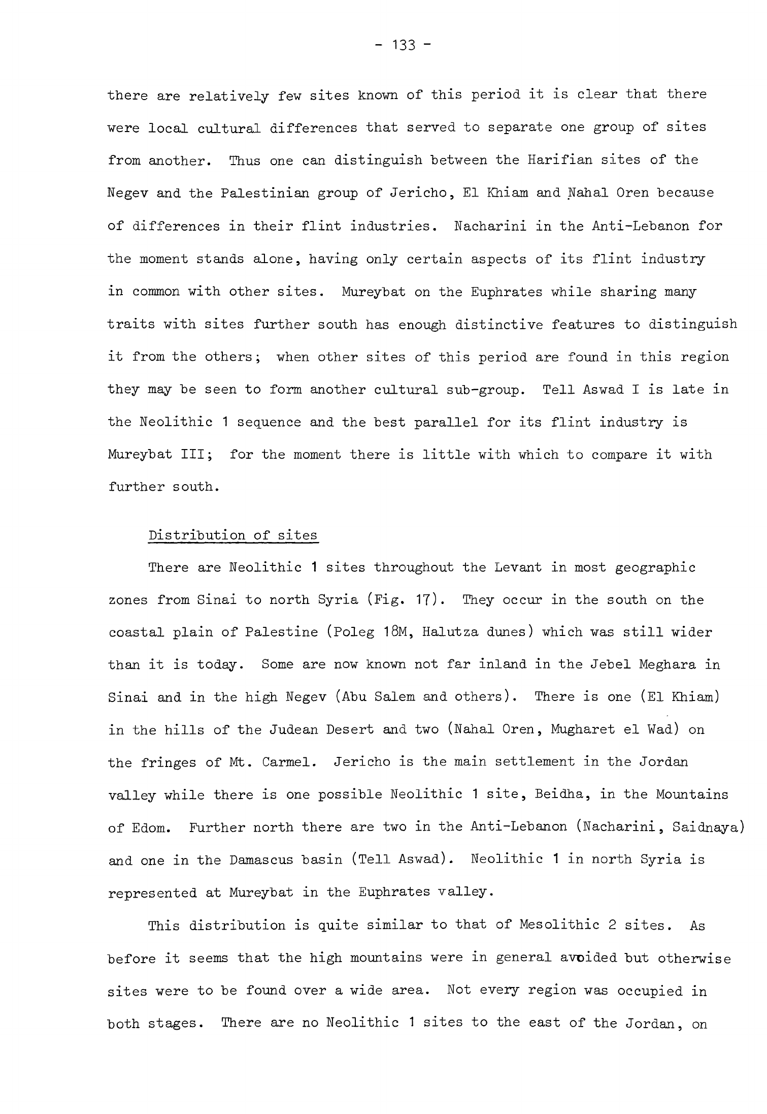
-
133
-
there
are
relatively
few
sites
known
of
this
period
it
is
clear
that there
were
local
cultural
differences
that
served
to
separate
one
group
of
sites
from
another.
Thus
one
can
distinguish
between
the
Harifian
sites
of
the
Negev
and
the
Palestinian
group
of
Jericho,
El
Khiam
and
Nahal
Oren
because
of
differences
in
their
flint
industries.
Nacharini
in
the
Anti-Lebanon
for
the
moment
stands
alone,
having
only certain
aspects
of
its
flint
industry
in
common
with
other
sites.
Mureybat
on
the
Euphrates
while
sharing
many
traits
with
sites
further
south
has
enough
distinctive
features
to
distinguish
it
from
the
others;
when
other
sites
of this
period
are
found
in
this
region
they
may
be
seen to
form another cultural
sub-group.
Tell
Aswad
I
is
late
in
the
Neolithic
1
sequence
and
the
best
parallel
for
its
flint
industry
is
Mureybat
III;
for
the
moment
there
is
little
with
which
to compare
it
with
further
south.
Distribution
of
sites
There
are
Neolithic
1
sites
throughout
the
Levant
in
most
geographic
zones
from
Sinai
to
north
Syria
(Fig.
17).
They
occur
in
the
south
on
the
coastal
plain
of
Palestine
(Poleg
18M,
Halutza
dunes)
which
was
still
wider
than
it
is
today.
Some
are
now
known
not
far
inland
in
the
Jebel
Meghara
in
Sinai
and
in
the
high
Negev
(Abu
Salem
and
others).
There
is
one
(El
Khiam)
in
the hills of
the
Judean
Desert and two
(Nahal
Oren,
Mugharet
el
Wad)
on
the
fringes
of
Mt.
Carmel.
Jericho
is
the
main
settlement
in
the
Jordan
valley
while
there
is
one
possible
Neolithic
1
site,
Beidha,
in
the
Mountains
of
Edom.
Further north
there
are
two
in
the
Anti-Lebanon
(Nacharini,
Saidnaya)
and
one
in
the
Damascus
basin
(Tell
Aswad).
Neolithic
1
in
north
Syria
is
represented
at
Mureybat
in
the
Euphrates
valley.
This
distribution
is
quite
similar
to
that
of
Mesolithic
2
sites.
As
before
it
seems
that
the
high
mountains
were
in
general
avoided
but
otherwise
sites
were
to
be
found
over
a
wide
area.
Not
every
region
was
occupied
in
both
stages.
There
are
no
Neolithic
1
sites
to
the
east
of
the
Jordan,
on
Fig.
17
Distribution
of
Neolithic
1
sites
scale
1=4,000.000

FIGURE
17
Distribution
of
Neolithic
1
sites
1
Mureybat
2
Nacharini
3
Saidnaya
4
Tell
Aswad
5
Nahal
Oren
6
Mugharet
el
Wad
7
Rakafet
8
Poleg
18M
9
Gilgal
10
Jericho
11
El
Khiam
12
Halutza
unnumbered
13
Halutza
unnumbered
14
Halutza
-
Site
87
15
Halutza
Dunes
4
16
Nahal
Lavan
108
17
Nahal
Lavan
110
18
Abu Salem
-
G12
19
Har
Harif
G8
20
Har
Harif
K3
21
Beidha
22
Lagama
IV
23
Moshabi
III
-
131*
-
the
slopes
of
the Mountains
of Lebanon
or
in
the
Beka'a.
There
are
also
fewer
Neolithic
1
sites
in
the
hill
country
"behind
the
coastal
plain
of
the
southern
Levant
than
in
Mesolithic
2.
Part
of the
explanation
for
this
change
in
the
distribution
pattern
may
simply
be
that
Neolithic
1
sites
have
not
been
noticed
in
these
areas
although
they
may
exist.
On
the
other
hand
several
of
these
areas
have
now been
carefully
surveyed
and
it
is
likely
that
a
few
sites
would
have
been
discovered
if
they
were
there.
People
may
have
avoided
these
areas
in
Neolithic
1
because
they
were
less
suitable
for
environmental
or
economic
reasons than
they
had
been
in
Mesolithic
2.
Settlement
was
quite
widespread
in
the
Negev
and
north
Sinai
as
it
had
been
in
Mesolithic
2.
The
vegetation
in
the
high
Negev
and
Jebel
Meghara
was
thinner
than
in
the
hills
further
north
making
the
uplands
more
attractive
for
settlement.
The
site
of Tell
Aswad
shows
that
the
floor
of
the
Damascus
basin
could
now
be
occupied
following
the
retreat
of
the
Pleistocene
lake.
Mesolithic
sites
have
not
been
found
on
the
old
lake
floor,
presumably
because
it
was
still
flooded
then,
although
it
is
possible
that
traces
of
occupation
might
have
been
covered
by
later
alluvium.
I
have
mentioned
22
sites
in
the
Levant
that
were
occupied
in
Neolithic
1;
if
one
includes
Beidha
the
total
is
23.
Of
these
18
were
open
sites,
three,
Mugharet
el
Wad,
Nahal
Oren
and
El
Khiam,
were
terrace
sites
and
two,
Nacharini
and
Rakafet,
shelters.
This
is
a
higher
proportion
of
open
to
shelter
sites
than
in
Mesolithic
2
when
many
caves,
particularly
in
Palestine,
were
still
occupied.
Neolithic
1
began
about
8500
B.C.
and
continued
until
about
7000
B.C.,
thus
lasting
approximately
1500
years.
This
is
about
the
same
length
of
time
as
the
duration
of
Mesolithic
2
which began
about
10,000 B.C.
and
ended
with
the
beginning
of
Neolithic
1.
Yet
while
a
maximum
of
23
Neolithic
1
sites
are
known
at
present
over
60
Mesolithic
2
sites
have
been
found.
It
may be
that
relatively
few
Neolithic
1
sites
have
been
recognised
in
surveys
carried
out
so
far.
There
are,
after
all,
few
type-fossils
in
the
artifact
assemblages
-
135
-
with
which
to
distinguish
Neolithic
1
from
Mesolithic
2
sites. The
chrono-
logy
proposed
here
may
be
in
error
by
several
hundred
years
so
that
Mesolithic
2
was
longer
and
Neolithic
1
shorter
than
I
have
suggested.
Other
factors
might further
reduce
the
gap
between
the
total
number
of
sites
for each
phase.
Nevertheless
on
present
evidence
nearly
three
times
the
number
of
sites
were
occupied
during
Mesolithic
2
than
in
Neolithic
1
even
though
both
stages
lasted
about
the
same
length
of
time.
Most
Neolithic
1
settlements
with
the exception
of
Mureybat
and
Jericho
have
thin
occupation
deposits
and
were
probably
occupied
briefly
or
inter-
mittently
as
were
most
Mesolithic
2
sites.
Mureybat
was
occupied
continuously
throughout
the
stage
although
still
without
a
massive
deposit
being
accumulated.
Jericho
was
an
extraordinarily
large
settlement
at
which,
although
it
was
not
occupied
for
the
whole
of
Neolithic
1,
a
great
mound
of
debris
was
built
up.
Although
far
fewer
Neolithic
1
than
Mesolithic
2
settlements
are
known
we have
a
much
better
idea
of
the
internal
chronology
and
cultural
development
of
this
stage.
The
long
stratified
sequences
at
Jericho
and
Mureybat,
the
quantity
of
llf
C
determinations
and
the
changes
in
typology
of
the
artifact
assemblages
all
can
be
combined
so
that
one
may
place
individual
sites
within
the
sequence.
Thus
the
Harifian
sites
would
all
appear
to
fall
early
in
Neolithic
1,
there
being
no
late
Neolithic
1
sites
known
as
yet
in
the
Negev
and
Sinai.
The
occupation
at
Tell
Aswad
I,
on
the
other
hand,
took
place
near
the
end
of
this
stage.
Neolithic
1
sites
vary
considerably
in
size
from
sites
of
less
than
100
sq
m
at
one
extreme
to
h
ha
at
the
other.
They
may
be
arranged
in
three
groups
according
to the
area they
cover.
The
first,
group
A,
includes
sites
of less
than
1000
sq
m.
Within
this
group there
is
a
clear
distinction
between
Nahal
Oren
which
covers
approximately
650
sq
m
(Stekelis,
Yizraely,
1963,
fig.
3;
Noy
et
al.,
1973,
fig.
1)
and
several
smaller
sites.
I
include
Mugharet
el
Wad,
Poleg
18M
and
Saidnaya
in
this
sub-group
as
they
are
all
probably
of
200
sq
m
or less
in
this
stage.
One
of
the
smallest
sites
is
Nacharini where
-
136 -
the
area
of
the
talus
and
cave
together
is
90
sq
m.
Group
B
consists
of
sites
from
1000
to
8000
sq
m.
Among
these
are
the
Harifian
sites,
Abu
Salem
(1600
sq
m)
(Marks,
Scott,
1976,
hk)
,
G8
(3000
sq
m)
and
K3
(8000
sq
m)
(Marks
et
al.
,
1972,
81,
82),
and
Mureybat
(a
maximum
of
U300
sq
m).
El
Khiam
should
be
included
in
Group
B
since
the
terrace
is
about
7500
sq
m
although
the
Neolithic
1
site
was
probably
smaller
than
this.
The
two
largest
sites,
Tell
Aswad
(a
maximum
of
2.7
ha)
and
Jericho
(a
maximum
of
h
ha)
comprise
Group
C.
These
are
several
times
bigger
than
any
of
the
other
sites.
If
we
compare
the
areas of
Neolithic
1
settlements
with
those
of
Meso-
lithic
2
sites
we
see
that most
Neolithic
1
sites
are
larger
although
there
are
fewer
of
them.
The
small
sites
of
the
sub-group
within
group
A
are
similar
in
size
to sites
within
the
categories
of
small and
medium
Mesolithic
2
sites
but
the
sites
in
group
B
are
larger
than
almost
all
in
the
previous
stage.
Those
in
group
C
are
at
least
four
times
bigger
than
the
largest
known
Mesolithic
2
site.
Only
the
sites
of
group
A
were
inhabited
by
communities
with
about
the
same
number
of
people
as
Mesolithic
2
families
or
composite
bands.
The
communities
living
in
group
B
sites
would
have
been
slightly
bigger
than those
on
most
Mesolithic
2
large
sites
while
the
inhabitants
of
group
C
sites
were
clearly
far
more numerous than
any
Mesolithic
2
community.
Economy
Some
evidence
for
economy
has
been
recovered
from
recent
excavations
of
Neolithic
1
sites
although
the
record
is
still
very
uneven.
Far
more
animal
bones
than
plant
remains
have
been
found
mainly
because
until
recently
there
were
no
special methods
available
by
which
seeds
could
be
separated from
the
soil.
There
is
some
indirect
evidence
from
artifacts
which
contributes
a
little more
information
on
the
economy.
The
economy
of
Jericho
is
of
special
interest
because
the
settlement
is
so
much
bigger
than
other
Neolithic
1
sites.
The
earliest
plant remains
found
at
the
site
were
recovered
from
PPNA
levels.
These
were
two
grains
of
-
137
-
emmer
(Triticum
dicoccum),
six
of
two-row
hulled
barley
(Hordeum
distichon),
h6
fig
pips
(Ficus)
and
three
fragments
of
a
legume
(Hopf,
19^9,
357).
Wild
apple
or
pear
(Pyrus),
pomegranate
(Punica),
fig
and
olive
(Olea)
charcoals
have
also
been
identified
from
these
levels
(Western,
1971,
36).
It
is
thought
that
the
pomegranate
charcoal
may
have
been
intrusive
as
it
is
not
certain
that
the
species
was
present
in
the region
at
this
early
date.
The
two
species
of
cereals
are
both
cultivated
types
so
cereal
agriculture
was
being
practised
at
Jericho.
The
barley
grains
were
smaller
than
those
found
in
later
phases
of
the
Neolithic
and
had
a
fragile
rachis
which
may
indicate
that
the
species
was
in
the
process
of
being
domesticated,
although
other explanations
are
possible
(Hopf,
1969,
358).
Several
questions
may be
asked
about
the cultivation
of
these
cereals.
Were
the emmer and
barley
domesticated
locally?
How
were
they
grown
and
what
contribution
did
they
make
to the
food
supply?
Cultivated
emmer
is
believed
to
have
been
developed
from
wild
emmer
(Triticum
dicoccoides);
the
two
types
are
closely
related
and
interfertile
but
wild
emmer
has
a
brittle
rachis
(Zohary,
1969,
^9)»
Triticum
dicoccoides
is
itself
thought
to
be
a
hybrid
of
wild
einkorn
(Triticum
boeoticum)
and
a
variety
of
goat-face
grass (Aegilops
speltoides)
(Renfrew,
1973,
kk).
Wild
emmer
may
have
originated
in
central
southern
Turkey
where
both
wild
einkorn
and
goat-face
grass
grow
together
in
the
wild
today.
Wild
emmer
itself
grows
in
only
a
few
places
in
the
Near
East
now.
One
area
is
in
the
Levant
and
comprises
southern
Lebanon,
the
Hauran,
Palestine
and
Transjordan;
another
is
southern
Turkey
and
northern
Iraq
(Zohary,
1969»
^9,
n.
17).
It
is
assumed
that
cultivated
emmer
originated
in
these
areas
(Harlan,
Zohary,
1966,
1079)
which
would
imply
that
the
cultivated
emmer grown
at
Jericho
had
been
domesticated
in
the
neighbourhood.
This
is
the
standard
explanation
for
the
origin
of
cultivated
emmer
which
is
accepted
by
most
archaeobotanists
today.
It
assumes,
however,
that
the
distribution
of
wild
emmer
is
almost
the
same
now
as
when
it
was
first
domes-
-K
i
<•>«.+•.
e*fl
"hpna.nRP
~l~i~htlf=>
r>1
-
138
-
then
(Zohary,
1969,
59).
As
we
have
seen
the
most
recent
evidence
indicates
that
the
climate
and
vegetation
of
the
Levant
in
the 9th
millennium
B.C.
were
significantly
different
from
now.
Wild
emmer
today
grows
on
limestone
and
basaltic
soils
and
is
found
from
100
m
"below
to
1600
m
above
sea
level
in
northern
Palestine
(Zohary,
1969,
52).
It
thus
tolerates
both
warm
and
cool
winters.
The
species
is
typical
of
the
Mediterranean
forest
and
intermediate
open
forest
of
the
areas
in
which
it
occurs today.
These
zones
were
much
more
extensive
in
the
9th
millennium
B.C.
than they
are
now,
stretching
in
a
wide
belt from
Sinai
north
and then
east
into
Mesopotamia.
The
principal
soils
of
this
enormous
area
are
derived
from
limestones
and
basalts
so
if
its
preferred
habitat
was
the
same
then
as
now,
another
questionable
assumption,
it
would
have
flourished
throughout
these
forest
zones.
Domestication
of
wild
emmer
could
thus
have
taken place
anywhere
in
the
broad
forested
zone
west
and
north
of
the
steppe
of
the
Syrian
interior.
It
has
frequently
been remarked
that
wild
cereals
when
found
today
often
grow
in
dense
stands
from
which
a
rich
harvest
may
be
gathered
(Harlan,
Zohary,
1966, 1078;
Harlan,
196?,
198).
These
cereals
are
abundant
now
because
they
grow
in
areas
that
formerly
were forested
but
from
which
much
of
the
tree
cover
has
been
removed.
Even
though
the
upper
Jordan
valley,
one
of
the
areas
cited,
has
been
preserved
from
grazing
for
a
generation
the
trees
have
not
yet
re-established
themselves
and
consequently
the
climax
vegetation
typical
of
the
region
in
earlier
periods
does
not
exist.
At
the
time
when
cereals
were
domesticated
the
tree cover
was
extensive
and
so
dense
stands
of
wild
wheat
would
have
been
found
only
rarely.
Once
wild
wheats
became
a
major
source
of
food
man
would
have
had
an
incentive
to
clear
more
open
ground
for
them,
itself
an
agricultural
technique,
and
also
to
transfer
them
to
open
country
where
they
could
grow
freely.
Herein
lies
an
important
reason
why
man
may
have
first
manipulated
and
then
domesticated
these
wheats.
This
discussion
has
been
based
on
the
assumption
that
Triticum
dicoccum
was
derived
from Triticum
dicoccoides
but
this
has
now
been
questioned by

- 139 -
Dennell.
He
has
argued
(1973,
329ff)
that
since
Triticum
dicoccum
has
so
far
been
found
on
several
archaeological
sites
at
an
earlier
date
than
Triticum
dicoccoides
the
latter
may
be
in fact
a
feral
offshoot
rather
than
the
progenitor
of
cultivated
emmer.
Triticum
dicoccum
may
have
originated
well
before
the
8th
millennium
and
he
cites
the
grains
of
this
type
found
in
Kebaran
levels
at
Nahal
Oren
as
possible
support
for
this.
These differences
of
opinion concerning
the
origin
of
cultivated
emmer
do
not
greatly
affect
its
archaeological
implications;
however
it
was
derived
it
seems
that
the
Levant
was
one
of
the
areas
in
which
it
originated.
It
is
thought
that
all
cultivated
barleys
are
derived
from
a
single
wild
type,
Hordeum
spontaneum
(Renfrew,
1973,
69).
This
species
also
grows
in
the
Mediterranean
and
open
forest
zones
today
(Zohary,
1969,
53).
It
prefers
some-
what
drier
conditions and
is
less
tolerant
of
cold than
the
wild
wheats
so
can
be
found
encroaching
on
the
steppe.
It
is
found
now
in
a
great
arc
from
the
Wadi
Arabah
north through
the
Levant
to
the
foothills
of
the
Taurus,
then
east
and
south-east
along
the
mountain
fringe almost to
the
Persian
Gulf.
This
zone
would
have
been
much
broader
in
the 9th
millennium
B.C.
and
wild
barley
would
consequently
have
been
more
widespread.
It
was
probably
domesti-
cated
at
many
places
in
this
area
including
the
vicinity
of
Jericho
at
about
the
same
time.
The
population
of
Jericho
multiplied
rapidly
in
the
Proto-Neolithic
and
PPNA.
Kenyon
has
suggested
that
between
2000
and
3000
people
may
have
lived
there
during
the
PPNA
(1969,
155),
an
estimate
that
is
probably
of
the
right
order
of
magnitude.
The
population
was
at
least
semi-sedentary
and
so
a
con-
siderable
bulk
of
food
would
have
been
required
to
feed
it.
Pack
animals
had
not
yet
been
domesticated
so
no
means
of
transport
existed
to
carry
heavy
loads
to
the
site
from
elsewhere.
The
inhabitants
must
therefore
have
obtained
their
food
from
the
vicinity
of the
site.
Chisholm
has
found
that
the
inhabitants
of
agricultural
settlements obtain
the
highest
returns
within
a
radius
of
1
km
from
the
site
(1968,
66)
but
that
at
a
distance
of
3
or
h
km
the
time
taken
to
travel
to
the
fields
seriously
hinders
production.
Higgs
and
Vita-
Finzi
have
suggested
that
the
inhabitants
of
most
sedentary
settlements
will
subsist
on
the
produce
of
a
territory
within
a
radius
of
5
km
of
their
hones
(19T2
9
31).
We
know
that
the
inhabitants
of
Jericho
were
planting
crops
from
which
they
derived
at
least
part
of
their
subsistence
and
it
follows
that
these
crops
must
have
"been
planted
near
the
site.
The
area
around
Jericho
today
is
too
warm
and
dry
for
cereals
to
grow
there
although
even
now
wild
"barley
grows
in
the
hills
immediately
to
the
west
of
the
site
(Western,
1971,
37).
This
area
was
both
cooler
and
moister
about
8000
B.C.
and
so
the
climate
would
have
been
more
favourable
for
early
agri-
culture.
The
soil
in
the
immediate
vicinity
of
Jericho
has
been
washed
down
by
the
Wadi
Makkuk
from
the
hills
behind
(Western,
1971,
35);
it
overlies
the
salty
marls
characteristic
of
the
floor
of
the
Jordan
valley
and
is
particularly
fertile.
Jericho
would
thus
have
enjoyed
quite
favourable
natural
conditions
for
early
agriculture.
Even
so
it
is
unlikely
that
the
rainfall
was quite
high
enough
for
cereal
crops
to
grow
regularly.
At
this
time
the
Dead
Sea
was
at
a
higher
level
than
now
and
its
shore
lay
not
far
south of
Jericho.
The
proximity
of
this
large
body
of
water
would
have
kept
the
water
table
in
the
lower
Jordan
valley
high
during
this
period.
The
Wadi
Makkuk
certainly
would
have flowed
for
longer
each
year
than
it
does
today
and the
great
spring
of
Ain
es-Sultan
would
also
have
had
a
greater
discharge.
There
would
thus
have
been
much
more
surface
and
sub-surface
water
around
the
site
than
now.
Kenyon
has
suggested
that
the
PPNA
inhabitants
irrigated
their
crops
(1970,
^5)
but
this
may
not
have
been
necessary
at
this
stage.
Emmer
and
barley
may
have
been
cultivated
on
the
relatively
moist
land
around
the
site
at
first
without
irrigation.
Although
a
change
in
climate
took
place
during
the
7th
millennium
B.C.
this
need
not
have
affected
cultivation
at
Jericho
during
the
life of
the
PPNA
settlement.
It
is
not
possible
to
describe
in
detail
how
plants
were
used
as
food
at
Jericho
as
few
remains
were
recovered.
The legume
fragments
may
have
been
gathered
in
the
wild
although, given the
size
of the
settlement,
it
is
more
likely
that
they
were
cultivated.
The
fig
pips
and
charcoal
indicate
that
fruits
were gathered
from
the
wild
in
the
hills
to
the
west
of
the
site.
No
doubt
many
other
species
were
gathered
from
the
wild
as
in
Mesolithic
2
and
a
few
others
cultivated
(Hopf,
1969,
357)
"but
their
remains
have
not
"been
found.
The
hollow
querns
from
the
PPNA
levels
would
have
"been
suitable
for
grinding
grains
and
also
acorns
which
may
still
have
contributed
to
the
diet.
Although
wild
foods
.may
have
been
an
important
supplement,
particularly
in
what
was
still
a
rich
environment,
the
inhabitants
must
have
depended
upon
agriculture
for
food
(Kenyon,
1969,
155).
Such
a
large
concentration
of
people could
not
have
subsisted
alone
on
the
wild
resources
known
to
have
been
available
to
them.
The
cereals,
legumes
and
fruits
would
have
provided
a
balanced
diet
but
the abundant
animal
bones found
on
the
site
indicate
that
the
meat
was
an
important
protein
supplement.
The
most
numerous
ruminant
bones
in
the
Proto-
Neolithic
and
PPNA
levels
were
of
gazelle,
probably
Gazella
dorcas.
This
species
accounted
for
36.91%
of
the
total
meat
available
from
the
animal
remains
in
the
PPNA
and
was
the
principal
source
of
meat
in
this
period
(Glutton-Brock,
1971
9
U8).
Both
males
and
females
were
represented
but
far
more
males
were
killed
than
females.
Some goat
bones
were
found
in
PPNA
levels
but
not
in
the
Proto-Neolithic.
Many
of
the
horn
cores
were
large
and
so
may
have
belonged
to
Capra
aegagrus
;
a
few
were
large
enough
to have
been
Capra
ibex
nubiana
(Glutton-Brock,
1971,
50ff).
Some
of
the
horn
cores
were
much
smaller
and
these
were
ascribed
to
young
or female
goats.
Sheep
were
also
present
in
the
PPNA
but
in
very
small
quantities
(Glutton-Brock,
Uerpmann,
197^-
9
273).
Large
pig
bones
of
the
wild
Sus
scrofa
were
quite
common
in
these
levels
(Glutton-Brock,
1971,
^3).
This
species
would
have
abounded
in
the
marshy
thickets
along
the
banks
of
the
Jordan.
Some
cattle
bones
were
also
found,
all
of
Bos
primigenius
(Glutton-Brock,
1971,
^5).
A
few
onager
(Equus
hemionus),
deer
and
antelope
bones
were
recovered
in
the
excavation
and
some
of
these
may
have
belonged
to
the
Proto-Neolithic
and
PPNA
levels.
Carnivore
bones
were
abundant
in
these
Neolithic
1
levels,
foxes
(Vulpes
vulpes)
being
the
most
common
of
all
the
mammals
found
(Glutton-Brock,
1969,
3^1).
This
species
flourished
in
Palestine
during
the
Mesolithic
(Kurte*n,
1965,
6k)
and
may
have
been
a
common
constituent
of
the
fauna
in
the
Jordan
valley.
Fox
bones
were
found
all
over the
site
and
so
they
were
regularly
caught
Glutton-Brock
believes
that
they
were
hunted
for
their
skins
and
for
food
which
may
well
have
been
the
case.
Their
presence
at
Jericho
in
such
large
numbers
is
striking
as
they
are
not
very
common
on
other
contemporary
sites.
It
may
be
that
the
inhabitants
of
Jericho specialised
in
the
preparation
of
fox
pelts
which
were
then
exchanged
with
other
communities.
The
remaining
carnivore bones
consisted
of
Canis
sp.
which
may
have
been
either
dogs or
wolves,
almost
certainly
wild,
and
several
Felidae
(Glutton-
Brock,
1969,
339
9
3^-3).
The
latter included
marten
(Martes
martes),
lynx
and
the
small
Libyan
cat (Felis
lybica).
There
is
nothing
in
the
morphology
of
the
bones
to indicate that
any
of
these
animals
was
domesticated
but
there
are
indications
that
they
were
at
least
hunted
selectively.
Gazelles
were
killed
much
more
frequently
than
other
ruminants
and
male
gazelles
more often
than
females.
Foxes,
too,
were
trapped
in
great
numbers
compared with
other
species. The
large
population
of
Jericho
would
soon
have
killed
off
or
frightened
away
most
of
the
gazelles
and
perhaps
even
the
foxes
had
they
hunted
these
species
indiscriminately.
Yet
there
always
seem
to
have
been
enough
for
them
to
take
throughout
the
Proto-Neolithic
and
PPNA.
It
would
seem
probable
that some
sort
of
game
conservation
was
practised
now
which
may
have
taken
the
form
of
the
protection
or
control
of
gazelle
herds
envisaged
by
Legge
(1972,
123).
The
inhabitants of
Jericho
in
Neolithic
1
would
thus
have
been
manipulating
the
gazelle more
thoroughly
than
anyone
sems
to
have
done
in
the
Mesolithic.
Like
their
Mesolithic
predecessors
the
people
of
Jericho
hunted
the
other
animals
in
the
vicinity from
time
to
time.
These
were
taken often
-
1U3
-
enough
to
"be
an
important
constituent
of
the
diet;
one
Bos
primigenius
after
all
would
have
fed
many
families
for
several
days.
The
economy
of
Jericho
in
the
Proto-Neolithic
and
PPNA
thus
depended
upon
the
cultivation
of
cereals
and
perhaps
other
crops.
The
vegetable
diet
was
supplemented
by collecting from
the
wild.
Meat
was
obtained
principally
by
the
selective
hunting
or
culling
of
gazelle
herds
but other
species
were
still
killed
quite
often
for
variety.
The
agricultural
aspect
of
the
economy
ensured
that
the
population
was
at
least
semi-sedentary
but
parties
would
still
have
spent
time
away
from
the
settlement
on
hunting
and
collecting
expeditions.
These
may
have
been
family
groups
which
would
have
been
able
to leave the
settlement
for
a
time
in
the
winter
after sowing the
cereals
and
also
in
the
late
summer
after
the
harvest.
Nevertheless
enough
people
probably
remained
at
the
site
throughout
the
year
for
Jericho
to be
described
as
a
sedentary
settlement
in
Neolithic
1.
Jericho
stands
out
from
contemporary
sites
because
of
its
great
size
and
the
tower
and walls
which
surrounded
it,
yet
the
houses
and
artifacts
are
like
those
found
elsewhere.
The
principal
difference
is
one
of
scale.
This
may
be
accounted
for
by
the
situation
of
the
site
which
at
this
period
was
unusually
favourable.
The
population
could
have
supported
themselves
per-
fectly
well
on
the
products
of
the
economy
suggested
by
the
evidence;
this
economy
was,
after
all,
not
very
different
from
the
Mesolithic
2
one
which
preceded
it.
There
is
no
need,
therefore,
to
invent
a
unique
economy
for
the
site
as
Anati
has
done
which
ignores
the
possibility
that
the
environment
may
have
been
more
favourable
at
the
time
the
site
was
first
occupied
than
it
is
now.
He
believes
that
the economy
was
based
on
the
collection
and
export
of
salt,
bitumen
and
sulphur
(1962,
31).
Salt
and
bitumen
are
widespread
in
the
Levant
and
were
locally
exchanged
but
sulphur
does
not
seem to
have
been
used
elsewhere.
Jericho
was not the
major
distribution
centre
of
these
commodities
which
could
not
have
been
exported
in
bulk
anyway
without
pack
animals.
Even
fewer plant
remains
were
found
in
the
Neolithic
1
levels
at
Nahal
Oren
than
at
Jericho
so
although
one
presumes
that
plants
were
important
in
the
diet
one
cannot
ascertain
much
about
how
they were
exploited.
Emmer
was
present
(Noy et
al.
,
1973,
table
6)
as
at
Jericho
so
the
inhabitants
may
well
have
been
growing
cereals.
Vetch
seeds
were
also
found
which
is
an
indication
that
the
plant
diet
was
well-balanced.
The
animal
bones
give
a
fairly
clear
picture
of
which
species
were
exploited
for
food.
Gazelle
was
the single
species
preferred
above
all
others,
accounting
for
87.65$ of
the
fauna
(Noy
et
al.,
1973,
table
3).
This
was
a
slightly
higher
percentage
than
in
the
Natufian
layers
but
the
relative
weight
of
meat
was
even
greater
because
very
few
cattle
and
other
large ruminants
were
killed
now.
A
very
high
proportion
of
gazelle
bones
was
also
found
in
the
first
series
of
excavations
(Ducos,
1968,
76)
so
the
pattern
was
true
for
the
whole
site.
The
only other
species
of
any
importance
were
goat
(Capra
aegagrus
k.95%
(Legge,
1972,
121))
and
pig
(3.W.
Fallow
deer
which
had
been
so
important
in
earlier
times
now
only
accounted
for
1.75$
of
the
animal
bones.
This
pattern
of
animal
exploitation
resembles
that
at
Jericho.
Most
of
the
meat
came
from
gazelle
at
both
sites
and
pig and
goat
were
important
supplements.
Gazelle
exploitation
reached
its
peak
in
this
phase
at
Nahal
Oren.
As
in
the
Natufian
a
high
percentage
(51-9$)
of the
gazelle
killed
were
young
animals
(Noy
et al.,
1973,
table
5)
so
the
herds
were
being
culled
very
selectively
indeed.
Apparently
the animal
was
abundant
in
the
neighbour-
hood
and
this
provided
the
basis
for
a
successful
killing
pattern.
By
now
their
dependence
on
gazelle
was
so
great
that
it
is
reasonable
to
presume
that
the
inhabitants
at
Nahal
Oren
were
controlling
the
herds
in
the
same
way
that
their
contemporaries
at
Jericho
appear
to
have
done.
This
hypothesis
is
reinforced
by
the
size
and
appearance
of
the
settlement.
The
huts
at
the
site
were
built
to be
occupied
for
several
months of
the
year
at
least.
The
population
could
not
have
.lived
there
regularly
for
as
long
as
this
without
a
dependable
food
supply.
While
it
appears
that they
now
grew
some
crops
the
catchment
was not
particularly
suitable
for
arable
farming
so
they
may
have
gathered
more
wild
plants
and
eaten
more
meat
than
the
inhabitants
of
Jericho.
It
is
possible
that
the
population
was
still
practising
transhumance
as
has
been
suggested
for the
earlier
phases
(Noy
et
al.,
1973,
96)
in
which
case
occupation
would
have
been semi-sedentary
rather
than
sedentary.
Very
little
more
direct
evidence
for
economy
has
been
found
on
Neolithic
1
sites
in
the
southern
Levant.
At
El
Khiam
a
few
caprine
and fox
bones
have
been
identified
(Ducos,
1968,
79)
which
accords
with
what
we
know
of
the
environment
of
the
site.
Not
very
much
is
known
either
about
the
fauna
on
Harifian
sites.
Apparently
a
wide
range
of
species
was
killed
at
Abu
Salem;
gazelle
and
wild
goat
were
particularly
abundant
and
onager
was
also
taken.
No
deer
bones
were
found
but
bird
bones
were
quite
common
(Marks,
1975a,
358).
Both
terrestrial
and
marine
molluscs
were
present,
some
of
which
may have
been
eaten.
There
are
some
similarities here
with
the
pattern
of
animal
exploitation
at
Jericho
and
Nahal
Oren.
Plant
foods
were
presumably
important
on
Harifian
sites
as
elsewhere
but
no
remains
have
been
recovered.
Abu
Salem,
G8
and
K3 are
all
on
top
of
the
Ear
Harif
plateau,
an
area
that
was
covered
with
Mediterranean
forest
at
the
time
they
were
occupied.
The
Harifian
sites
in
the
Halutza
dunes
are
on
the
much
lower
ground
of
the
coastal
plain
in
more
open
forest.
The
catchments
of
these two
groups
of
sites
offered
complementary
seasonal
resources
which
could
be
most
satisfac-
torily exploited by
transhumant
groups.
They
may
have
spent
the
winter
on
the
coastal
plain
which
would
have
been
much
warmer
than
the
Har
Harif.
The
pasture
on
the
lowlands
would
have
supported
large herds
of
gazelle
which
may
have
been
controlled
as
seems
to
have been
the
case
further
north.
Annual
food
plants,
either
cultivated
or
wild,
would
also
have
been
available
until
the
end
of
spring.
Then
these
groups
may
have
moved
up
to
the
plateau
where
there
would
be
some
pasture
through
the
summer
for
gazelle
and
goats.
The
topo-
graphy
of
this
area
provided
a
congenial
habitat
for
goats
and
we have
already
seen that
their
remains
are
quite
numerous
at
Abu
Salem.
Transhumance
seems
also
to
have
"been
the
pattern
in
the
Anti-Lebanon
for
Nacharini
can
only
have
been
occupied
in
the
summer
months.
Some
of
the
animal
bones
from
the
Neolithic
1
occupation
at
this
site
have
been
identified.
They
include
gazelle,
fallow
deer
(Dama
mesopotamica),
equid,
cattle
and
sheep/goat.
These
species
-would
have
fed
on
the
high
pastures
in
the
mountains
and
some
of the
herds
may
have
been
controlled.
In
winter
the small
group
which
inhabited
the
site
and
probably
many
of
the
wild
ruminants
would
have
moved
down
to
the
floor
of
the
Beka'a.
Samples
of
plant
remains
and
animal
bones
were collected
at
Mureybat
by
both
van
Loon
and
Cauvin.
In
van
Loon's
excavation
flotation
was
used
to
extract
seeds
from
two
baskets
full
of
earth
from
every
stratum
(van
Loon,
1968,
280).
Most
of the
samples
came
from
strata
of the
Neolithic
1
occupation.
A
very
mixed
collection
of
seeds
was
found
in
each
sample,
reflecting
the
different ways
in
which
they were
processed
and
used
on
the
site.
Two-seeded
wild-type
einkorn
(Triticum
boeoticum
var.
thaoudar)
was
particularly
common
and
may
have
been
an
important food
plant
(van
Zeist,
Casparie,
1968,
hQ).
Wild-type
barley
(Hordeum
spontaneum)
did
occur
but
in
much
smaller
quantities
(van
Zeist,
1970,
17*0
so
it
is
less
likely
that
it
was
a
major
constituent
of
the
diet.
Of
the
legumes,
small
wild
lentils
(Lens
nigricans) and
bitter
vetch
(Vicia
ervilia)
were
collected
for
food
(van
Zeist,
1970,
175) as
they
had
been
at
Abu
Hureyra
in
the
Mesolithic.
There
were
also
a
few
fragments
of
pistachio
nuts
(Pistacia).
Some
Astragalus
seeds
were
found
but
these
may
have
been brought
to
the
site
with
their
parent
plants
for
fodder.
Among
the
other
plant
remains
were
Polygonum
which
may
have
been
eaten,
grasses
and
Chenopodiacae
seeds.
Charcoal
from
the
site
has
also
been
identified. Most
of
it
was
poplar but
there
was
some
tamarisk
and
ash,
all
species
which
would
have
grown
on
the
flood-plain
of
the
river.
All
these
species except
the
wild-type
einkorn
would
have
certainly
grown
in
the
vicinity
of
Mureybat.
Van
Zeist
has
pointed
out
that
wild-type
einkorn
is
not
found
on
the
north
Syrian
plain today
although
it
is
found
in
southern
Turkey.
He
thought
it
could
have
grown
around
Mureybat
at
the
time
the
site
was
occupied
only
if
it
was
cooler and
moister
then
(1968,
52).
He
did not
"believe
that
the
climatic
evidence
indicated
this
so
he
concluded
that
the
wild-type
einkorn
must
have
been
harvested
in
the
hill
country
about
150
km
to
the
north.
We
have
already
seen
that
on
the latest
evidence
the
temperature
was
lower
then,
the
rainfall
was
more regular
and
may
even
have
been
a
little
greater.
This
means
that
the
conditions
in
this
region
were
more
suitable
then
for
wild-type
einkorn
which
anyway
grows
in
a
wide
climatic
range
today
(Zohary,
1969,
U8).
As
the
transport
of
large
quantities
of
grain
to
the
site
from
so
far
away
would
have
been
almost
impossibly
difficult
one
may
reasonably
presume
that
wild-type
einkorn
grew
around Mureybat
and
that
all
the
food
plants
the
inhabitants
used were
available
locally.
We
do
not
know
for
certain
if any of
these
plants
was
being
cultivated
but the
evidence
from
the
Mesolithic
levels
at
Abu
Hureyra
indicates
that
wild-type
einkorn
and
wild-type
barley had
already
been
used
for
a
long
period
of time
and
that
the
wild-type
einkorn
was
probably
already
being
cultivated
there.
Cultivated
einkorn
and
barley
are
found
in
the
aceramic
Neolithic
levels
at
Abu
Hureyra
no
more than
a
millennium
later
than
the
Neolithic
1
levels
at
Mureybat.
It
seems
likely,
therefore,
that
these
cereals
were
being
cultivated
by
the
inhabitants
of
Mureybat
even if
there
is
no
evidence
that
they
changed
their
morphology.
This
would
only
occur
when
certain
harvesting
techniques
such
as
reaping
with
sickles
were
introduced
but
cereals
could
have
been
harvested
from
planted
fields
for
a
long
period
before
that
without
any
morphological
change
taking
place
(Hillman,
1975
9
72).
None
of
the
animal bones
recovered
at
Mureybat
can
be
ascribed
to
mor-
phologically
domestic
types.
The
most
numerous
species
found
in
both
series
of
excavations
were
gazelle (Gazella
sp.),
aurochs
(Bos
Primigenius)
and
wild
ass
(Equus
Asinus
palestinae)
(Ducos,
1975a,
193;
1972,
300;
1970,
287)
It
proved
impossible
to
determine
the
type
of
gazelle.
The
equid bones
were
at
first
thought
to
be
from
an
onager
(van
Loon,
1968,
279)
but
Ducos
now
believes
they
belong
to
an
ass,
a
species
that
was
very
common
in
north
Syria
(I975b,
71).
Whichever
name
the
species
is
given
it
is
likely
to be
the
same
animal
as
the
onager
or
ass
which
has
been
found
in
some
quantity
at
Abu
Hureyra
and
a
number
of
other
sites
in
the
Levant.
These
three
species
appear
to
have
been
of
approximately
equal
importance
in
the
diet
in
the
early
phases
of
occupation
at
Mureybat,
Then
in
phase
III
most of
the
meat
was
obtained
from
cattle
and
ass
and
far
fewer
gazelle
were
taken.
It
would
seem
that
these
three
species
were
prolific
in
the
open
park-like
environs
of
Mureybat.
Animals
of
different
ages
were
killed
at
random,
there
being
no
strong
bias
towards juveniles
(Ducos,
1970,
273) so
it
appears
that
they were
hunted
in
the
wild
rather
than
herded.
The
fall
in
the
number
of
gazelle
taken
in
phase
III
may
have
been because
they
had
been over-exploited without
steps
being
taken
to
conserve
numbers
as
was
happening
further
south.
Another
factor
may
have
been
that
cattle
and
ass
were
then
considered
to
be
more
generally
useful
providing
not
only more
meat,
especially
Bos
primigenius,
but
also
hides
and
other
products.
Throughout
Neolithic
1
at
Mureybat
a
number
of
other
animals
were
hunted,
among
them
fallow
deer
(Dama
mesopotamica)
in
some
quantity,
a
very
few
red
deer
(Cervus
elaphus)
which
were
apparently
still
in
the
area,
a
few
sheep
(Ovis
orientalis),
pigs
(Sus
scrofa
cf.
libycus)
and
rabbits
(Lepus
sp.)
(Ducos,
1975a,
193ff;
van
Loon,
1968,
279).
Birds,
especially
pelicans,
fish
and
shellfish
(Melanopsis)
were
taken
from
the
Euphrates
and
marshes
of
the
valley
floor.
It
now
appears
that
fewer
fish
and
shellfish were
eaten
in
phase
III
than
before but
numerous birds
were
still
being
killed.
This
pattern
of
exploitation
is
a
little
different
from
sites
in
Palestine.
In
part
it
reflects
the
different
plants
and
animals
that
were
available
in
the
vicinity
of
Mureybat
and
also
the
more open
vegetation. There
is
a
presumption
that
cereals
were
now being
deliberately
planted
even
if
they
had
not
yet
changed
morphologically.
All
the
animals
eaten
on
the
other
hand
were
hunted
or
trapped.
The
rich
grassland
around
the
site
may
have
maintained
-
1U9
-
large
herds
which
the
relatively
small
population
at
Mureybat
did
not
seriously
diminish,
except
possibly
those
of gazelle.
They
may
not
have
needed
to
herd
these
animals
in
the
manner
of
their
contemporaries
in
Palestine.
Wildfowling
and
fishing
were
important
supplements
until
quite
late
in
the
occupation
of
the
site.
The
one
other
Neolithic
1
site
for
which
there
is
any
evidence
for
economy
is
Tell
Aswad.
This
site
is
in
an
unusual
situation near
lakes
and
marshes.
No
information
is
available yet
on
what
plants
were
eaten
but
the
area
would
have
been
quite
rich
in
edible
species
which
could
have
been
col-
lected.
Some
could
also
have
been
cultivated
on
the
moist
land
around
the
site
where
the
water
table
was
high.
Several
species
of
animals
were
killed
for
food,
among
them
sheep/goat,
cattle,
deer
and
an
equid
(de
Contenson,
1972,
79).
We
do
not
know
if
any
of
the
animals
were
herded
but
most
were
probably
hunted.
The
bird
bones
and
fish
vertebrae
found
on
this site
indicate
that
the
inhabitants
also
went
wildfowling
in
the marshes
and
caught
fish
in
the
lakes.
The
population
of
Tell
Aswad
lived
somewhat
differently
from
their
contemporaries
elsewhere.
Their
environment
was
rich
in
vegetation
and
there
were
abundant
herds
of ruminants
on
the
floor
of
the
Damascus
basin.
In
addition
migratory
and
other birds
were
attracted
to
the
lakes
which
teemed
with
fish.
The
area
probably
carried
a
higher
biomass
than
most
other
regions
of
the
Levant
which
would
have
provided
ample
food
for the
large
population
of
Tell
Aswad.
They
need
not
have
resorted
to
herding
or
deliberate
cultivation
to
support
themselves
as
the
inhabitants
of some
Neolithic
1
sites
were
doing.
Discussion
Having
considered
the
archaeological
evidence
for
Neolithic
1
I
now
wish
to
examine
further
the
way
of
life
of
the
people
who
lived
in
the
Levant
at
that
time.
In
particular
I
would
like
to
look
at
the
changes
which
were
taking
place
in
economy
and
society
and
attempt
to
explain
them.
We
have
seen
that
the
culture
of
Neolithic
1
throughout
the
Levant
was
derived
directly
-
150
-
from
the
Mesolithic.
Neolithic
1
sites
were
also
situated
in
the
same
general
regions
as
Mesolithic
sites.
If
we
disregard
chronological
sub-
divisions
and
regional
differences
between
sites
in
Neolithic
1
but look
at
them
together
we
see
that
the
pattern
of
settlement
had
nevertheless
been
modified.
Assuming
as
we
did
when
comparing
Mesolithic
1
with
Mesolithic
2
that
the
ratio
of
sites
found
to
those
destroyed
was the
same
in
Neolithic
1
as
in
Mesolithic
2,
an
assumption
that
seems
reasonable
given
the
similarities
in
cultural
remains,
we
see
that
there
were
fewer
Neolithic
1
sites
than
in
the
preceding
stage
but
that
most
of
them
were
larger.
The
number
of
Neo-
lithic
1
settlements
found
so
far
is
about
one
third
that
of
known
Mesolithic
2
sites.
It
would
seem
that
many
fewer
sites
were
inhabited
now
but
that
the
population
of
each
site
was
much
greater
than
before.
We
must remember,
too,
that
the
more
mobile
groups
of
Mesolithic
2
may
have
visited
two
or
more
sites
in
the
course
of
a
year
while
the
more
sedentary
Neolithic
1
population
may
have
remained
at
their
settlements
for
much
or
all
of
the
time.
This
in
itself
would
account
for
part
of the
reduction
in
the
number
of
sites
which
were
used.
Although
considerable
changes
were
taking
place
in
the
pattern
of
settlement
there
is
no
reason
to
suppose
that
the
population
in
Neolithic
1
either
increased
or
decreased
markedly.
If
we look
at
the
distribution
of
sites
in
more
detail
we
see
that
certain
zones
were
no
longer
inhabited.
The
slopes
of
the
Judean
hills,
the
TransJordan
uplands
and
the
mountains
of
Lebanon
were
all
avoided
in
Neolithic
1
although
they
had
been
occupied
in
the
Mesolithic.
Most
Neolithic
1
sites
were
on
lower
ground
in
more
open
country. This
noticeable
modification
of
the
Mesolithic
settlement
pattern
can
be linked
to
the
changes
in
economy
which
were
taking
place.
The
Neolithic
1
population
relied
more
on
cereals,
either
wild
or
cultivated,
and
in
some
cases
the
control
of
herds
of
gazelle
and
other
herbivores.
As
a
truly
agricultural
economy
developed
there
was
a
need
for
more
open
land
suitable
for
pasture
and the
growing
of
cereals.
The
Mediterranean
vegetation
zone
was
still
wooded
so
this
would
have
required
-
151
-
the
clearance
of
trees
even
on
lower
ground;
there
are
indications
of
such
disturbance
of
vegetation
"before
this
in
the
Mesolithic
layers
at
Abu
Hureyra
(Hillman,
1975,
73).
Neolithic
1
sites
are
situated
in
the
Mediterranean
and
intermediate
forest
zones
and
also
on
the
edge
of
the
open
steppe beyond.
These
environ-
ments
offered
a
wide
range
of
food resources and
this
variety
is
reflected
in
the
diversified
economy
of
Neolithic
1
sites.
The
economy
was
"based
on
two
or
more
of
the
following:
agriculture,
herding,
collecting
and
hunting.
As
in
the
Mesolithic
many
plants
and
animals
within
the
catchment
of each
settlement
were
exploited
but
the
main
difference
now
was
that
agriculture
made
an
important
contribution
to
the
food supply
at
some
sites.
As
a
result
Jericho
seems
to
have
been
inhabited
permanently.
That
is
to
say,
a
pro-
portion
of the
population
lived
there
all
the
year
round
although
some
parties
engaged
in
herding,
hunting
and
gathering
may
have
spent
time away
from
the
site
at
certain
seasons.
At
least
two
other
sites,
Mureybat
and
Tell
Aswad,
may
also
have
been occupied
permanently
but
the
economy
of
Mureybat
was
based
upon
wild
resources
to
a
greater
extent
than
at
Jericho.
Deliberate
planting
of
wild-type
cereals
probably
took
place
at
Mureybat but
animals
were
hunted
there
not
herded.
We
do
not
know
what
farming
techniques
if
any
were
used
at
Tell
Aswad
but
the
environment
there
was
rich
enough
to
support
substantial
occupation
for
a
long
period
of
time.
The
catchments
of
all
three of these
sites
included
much
potential
arable
and
grazing
land.
This
was
also
the
case
at
Saidnaya,
Poleg
18M
and
the
sites
in
the
Halutza
dunes
so
it
is
possible,
at
least,
that
a
little
agriculture
was
practised
at
these
sites. In
view
of
the
scanty
remains
found
on
them
it
is
more
probable
that
they were attractive
because
the
woodland
was
thinner
in
their
vicinity
so
that
these
areas
would
have offered
better
grazing
for
herbivores
and
a
more suitable
habitat
for
wild
cereals.
The
catchments
of
other
Neolithic
1
sites
were
much
less
suitable
for
agriculture.
Occupation
on
all
of
these,
the
Harifian
sites
in
the
Har
Harif
-
152
-
and
Jebel
Meghara, El
Khiam,
Nahal
Oren,
Mugharet
el
Wad
and
Nacharini
vas
semi-sedentary
as
if
many
or
all
of
their
inhabitants
were
practising
trans-
humance.
The
settlement
pattern
suggests that
transhumance
was
a
more
regular
way
of
life than
it
had
been
in
the
Mesolithic.
Although
there
is
evidence
for
agriculture
and
the
herding
of
goats
at
Nahal
Oren
the
inhabitants
of
these
sites
seem
to
have
relied
on
wild
resources
for
much
of
their
food,
even if
these
were
exploited
intensively.
These
differences
in
the
way
of
life
are
reflected
in
the
size
and
aspect
of
Neolithic
1
settlements.
At
one
extreme
is
Nacharini,
a
very
small
seasonal
hunting
or
herdsmen's
camp,
and
at
the
other
Jericho,
a
great
agglomeration
of
tightly
packed
dwellings
inhabited
by
a
population
of
farmers.
The
range
of settlement
types
was
much greater
in
Neolithic
1
than
in
the
Mesolithic.
In
attempting
to
explain
these
developments
in
economy
and
type
of
settlement
it
will
be
useful
to
consider
the
question
of
population
growth.
We have
already
seen
that
there
appeared
to
have
been
a
considerable
increase
in
population
during
Mesolithic
2.
The
adoption
of
a
more
sedentary
way
of
life
would
have
increased
the
birthrate
because women
no
longer
had
to
carry
their
infants
long
distances
when
gathering
food
or
moving
camp.
This
eased
the
pressure
on
them
to
restrict
the
number
of
children
born
and
shortened
the
interval
between
births
(Lee,
1972,
338ff).
The
environment
was
also
much
richer
in
plant
and
animal
foods
than
it
had
been
during
Mesolithic
1
and
this
increased
food
supply
would
have
encouraged
sedentism
and
a
higher
population.
The
increase
in
population
and
the
formation
of
large
concentra-
tions
of
people
in
bigger
settlements
would
in
time
have
led
to
pressure
on
the
food
supply.
This
is
reflected
in
the
more
intensive
food
procuring
activities
of
the
people
of
Mesolithic
2
compared
with
their
predecessors.
A
point
would
have
been
reached
when
even
these
activities
would
have
been
insufficient
to feed
the
population.
It
would
then
have
been
necessary
to
develop
new
ways
of
increasing
the
food
supply
which
we
see
in
the
changes
of
economy
in
Neolithic
1.
What
happened
was
not
really
new
but
a
further
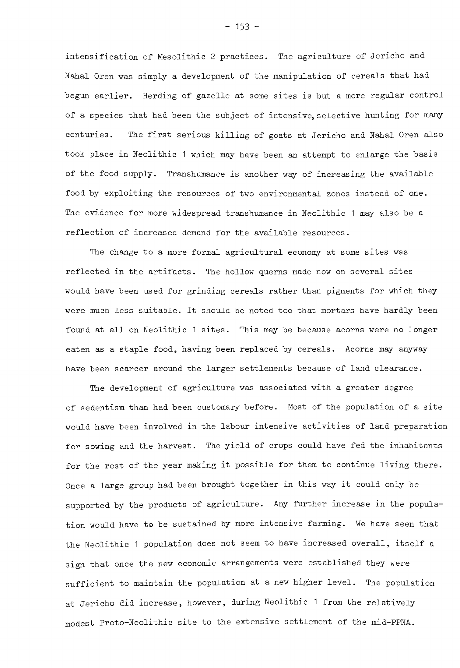
-
153
-
intensification
of
Mesolithic
2
practices.
The
agriculture
of
Jericho
and
Nahal
Oren
was
simply
a
development
of
the
manipulation
of
cereals
that
had
begun
earlier.
Herding
of
gazelle
at
some
sites
is
"but
a
more
regular
control
of
a
species
that
had
been
the
subject
of
intensive,
selective
hunting
for
many
centuries.
The
first
serious
killing
of goats
at
Jericho
and
Nahal
Oren
also
took
place
in
Neolithic
1
which
may
have
been
an
attempt
to
enlarge
the
basis
of
the
food
supply.
Transhumance
is
another
way
of
increasing
the
available
food
by
exploiting
the
resources
of
two
environmental
zones
instead
of
one.
The
evidence
for
more
widespread
transhumance
in
Neolithic
1
may
also
be
a
reflection
of
increased
demand
for
the
available
resources.
The
change
to
a
more
formal
agricultural
economy
at
some sites
was
reflected
in
the
artifacts.
The
hollow
querns
made
now
on
several
sites
would
have
been
used
for
grinding
cereals
rather
than
pigments
for
which
they
were
much
less
s.uitable.
It
should
be
noted
too
that
mortars
have
hardly
been
found
at
all
on
Neolithic
1
sites.
This
may
be
because
acorns
were
no longer
eaten
as
a
staple
food,
having
been
replaced
by
cereals.
Acorns
may
anyway
have
been
scarcer
around
the
larger
settlements
because
of
land
clearance.
The
development
of
agriculture
was
associated
with
a
greater
degree
of
sedentism
than
had
been
customary
before.
Most
of
the
population
of
a
site
would
have
been
involved
in
the
labour
intensive activities
of
land
preparation
for
sowing
and
the
harvest.
The
yield
of
crops
could
have
fed
the
inhabitants
for
the
rest
of the
year
making
it
possible
for
them
to
continue
living
there.
Once
a
large
group
had
been
brought
together
in
this
way
it
could
only
be
supported
by
the
products
of
agriculture.
Any
further
increase
in
the
popula-
tion
would
have
to
be
sustained
by
more
intensive
farming.
We
have
seen
that
the
Neolithic
1
population
does
not
seem
to
have
increased
overall,
itself
a
sign
that
once
the
new
economic
arrangements
were
established
they
were
sufficient
to
maintain
the
population
at
a
new
higher
level.
The
population
at
Jericho
did
increase,
however,
during
Neolithic
1
from
the
relatively
modest
Proto-Neolithic
site
to
the
extensive
settlement
of
the
mid-PPNA.
The
economy
of
the
settlement
must
have
been
further
modified
during
this
stage
in
order
to
feed
the
growing
population
"but
the
evidence
is
too
meagre
for
us
to
document
it.
The
artifacts
give
a
slight
indication
of
what
was
happening.
Sickle
blades
became
more
numerous
later
in
the
PPNA;
by now
these
were
probably
being
used
for
reaping
and
this
increase
may
have
been
associated
with
a
change
in
reaping
techniques.
Interestingly
enough
a
similar
increase
in
sickle
blades occurred
in
phase
III
at
Mureybat
as
though
the
same
change was
taking
place
there.
The
beginning
of
Neolithic
1
approximately
coincided
with
the
onset
of
the
Holocene
so
we
should
consider
what
part
climatic
and
environmental
changes
played
in
the
developments
in
economy,
settlement
and
artifacts.
Climatic
change
cannot
be
invoked
as
a
primary
cause
if
only
because
this
happened
about
8000
B.C.
or
a
little after
whereas
Neolithic
1
seems
to
have
begun
about
8500
B.C.
It
may
have
had
some
effect,
however,
on
the
development
of
Neolithic
1.
After
8000
B.C.
the
temperature increased
and
there
was
a
slight
drop
in
rainfall.
These
two
factors
could
have
brought
about
a
slight
con-
traction
of
the
Mediterranean
forest
zone.
This
trend
would
have
aided
the
Neolithic
1
population
whose
economy
now
depended
more
on
cereals
and
herds
of
animals,
both
of
which
needed
open
country
to
flourish.
Land
cleared
for
crops or
grazing
would
not
have
been
recolonized
by
shrubs
and
trees
quite
so
quickly
now.
Although
the
changes
in
population,
economy
and
settlement
which
were
taking
place
were
very
important
we
should
remember
that
almost
all
Neolithic
1
sites
were
in
the
Mediterranean
and
open
forest
zones
and
that
none
was
situated
far
out
in
the
steppe
or
desert
regions.
Approximately
the
same
areas
were
occupied
as
in
Mesolithic
2
so
that
the
increase
in
population
which
had
taken
place
then
could
be
accommodated
by
exploiting
the
resources
of the
region more
intensively
or
in
a
different
way.
It
was not
necessary
for
any
group
to
expand
into
the
marginal
zones
in
order
to
survive.
These
alterations
in
population,
settlement
and
economy
also
affected
-
155 -
the social
system. If one
examines
the
area
of
Neolithic
1
sites
then
the
smaller
ones,
group
A,
can
have
"been
occupied
by
very
fev
people.
Nacharini
may
have
"been
inhabited
by
one
family
and
other
group
A
sites
by
composite
bands.
Thus
composite bands
still
existed
as
a
form
of
social
organization
even
in
their
economy
was
in
certain
instances
somewhat
different
from what
it
had
been
during
the
Mesolithic.
Group
B
sites
tended
to
be
larger
than even
the
biggest
Mesolithic
2
sites
so
that
their
inhabitants
were
correspondingly
more numerous.
The
grouping
of
bands
which
I
suggested
was
a
feature
of
the
larger
Mesolithic
2
settlements
was
taken
further
here.
Most
of
these
larger
communities
still
seem
to
have
been
semi-sedentary
so
they
may
have
split
into
their
component
bands
and
left
the
settlement
at
certain
seasons.
One
might
next
ask
what
were
the
social
arrangements
within
Group
B
and
C
settlements?
In
a
recent
article
Flannery
has
pointed
out
that
most
of
the
huts
in
these
sites
were
so
small
that
they
can
only
have
been
occupied
by
one
or
two
people
(1972,
30ff)
.
Any
large
buildings
may have
been
communal
meeting
or
guest
houses
while
the
smallest
structures
were
probably
used
for
storage
and
other
activities,
not
as
dwellings.
The
population
of such
settle-
ments
might
have
been
smaller
than
one
would
suppose
and
certainly
much
less
than
if
one
assumed
that
every
hut
was
occupied
by
a
nuclear
family.
On
ethno-
graphic
analogy
polygyny
may
have
been
practised,
husband
and wives
living
in
separate
huts.
The
men
at
least
would
have
been
related.
Life
in
the
settlement
would
have
been
organized
on
a
communal
basis,
stored
food
supplies
being
shared.
Most
tasks
would
have
been performed
by
groups
of
males
or
females
rather
than
families.
The
communal
nature
of
the
settlement,
close
kinship
ties
and
the
sexual
division
of
labour
are
basic
patterns
carried
over
from
composite
bands
which
may
be
assumed
to
have
characterised
most
Neolithic
1
sites.
Polygyny
cannot
be
demonstrated
as
we
do
not
yet
know
if
the
contents
of
huts
in
Neolithic
1
sites
were
functionally
distinct
(Flannery,
1972,
33).
The
problem
of
how

-
156
-
many
people
occupied
each
hut
and
thus
how
families
were
organized
is
more
complex
than
Flannery
suggests.
He
relies
heavily
on
the
work
of
Naroll
who
after
comparing
settlements
of
18
modern
primitive
societies
calculated
that
each
person
needed
about
10
sq
m
of
floor
space
in
a
dwelling
(1962,
588).
This
figure
may
be
a
convenient
one
to
use
but
Naroll
!
s
own
data
show that
in
certain
societies the
norm
may
be
several
square metres
more
or less
than
this.
When
Naroll's
mean
was
applied
to
a
study
of
a
modern
Fulani
village
inhabited
by
a
group
organized
in
precisely
the
way
Flannery
envisaged
it
was
found
to
underestimate
quite
considerably
the
area
required
by
each
individual
(David,
1971
,
119).
In
a
study
of
Californian
Indians
it
was
shown
that
each
individual
may
require
as
little
as
20
sq
ft
of
floor
space
(Cook,
Heizer,
1968,
11^)
so
the
parameters
here
are
uncomfortably
wide.
The
important
point
to
establish
is
whether
it
is
reasonable
to
suppose
each
hut
was
occupied
by
one
or
two people
at
most
or
a
family
of
parents
and
children.
The
structures
of
the
Neolithic
1
sites
we
are
considering
were
clustered
together
to
form
a
nucleated
settlement.
They
differed
in
this
respect
from
the
extensive
spread
of
structures
in
a
Fulani
compound
or
in a
Tiv
village,
one
of the
examples
quoted
by
Flannery
(1972,
30).
The
huts
were
more
sub-
stantial,
took
more
time
to
build
and
would
have
lasted
longer
than
these
African
ones.
Their
inhabitants
may
have
been
content
with
less
covered
space
than
Flannery
proposed.
Bearing
this
in
mind
let
us
look
again
at
Neolithic
1
huts.
Those
2
m
in
diameter
or
less
could
only
have
housed
a
single
person
or
served
as
stores.
Huts
from
2
to
k
m
in
diameter
(3
-
12.5
sq
m
floor
area)
could
have
been
inhabited
by
one
or
two
people.
The
larger
ones
from
h
to
6
m
in
diameter
(12.5
-
28
sq
m)
are
more
problematical.
These
might
still
have
been
occupied
by
one
or
two people
if
they
wanted
the
space
"but
there
was
enough
floor area
for
several people
to
sleep
in
these.
The
large
huts
certainly
could
have
housed
a
nuclear
family
but
were
not
big
enough
for
an
extended
family,
a
form
of
social
grouping
which
does
not
seem
to
have
been
characteristic
of
Neolithic
1
settlements.
-
157
-
Turning
now
to
the
settlements
themselves
the
pattern
is
more
varied
than
Flannery
allows.
At
Nahal
Oren
the
core
of
the
site
was
a
group
of
small
huts
2
to
3
m
in
diameter
(Fig.
12).
These
were
surrounded
"by
several
larger
huts
k
to
5
m
in
diameter;
one
excavated
"by
the
Cambridge
team
was
also
about
this size
(Noy
et
al.
a
1973,
fig.
2b).
This
settlement
could
be
interpreted
in
the
way
Flannery
suggests
but
I
think
it
likelier
that
the
larger
huts
in
the
outer
ring
were
inhabited
by
more
than
two people,
perhaps
a
married
couple
and
their
children.
This
would
mean
that
the
nuclear
family
was
already
crystallizing
as
the
fundamental
social
grouping.
Looked
at
in
this
way
the
population
of
Nahal
Oren
would
still
have
been
quite
small,
no
more
than that
of
a
composite
band.
The
structures
at
Abu
Salem
were
also
of
two
sizes,
small
ones
like
those
at
Nahal
Oren
and
larger
ones
3
or
h
m
in
diameter.
As
these
were
smaller
than
the
large
ones
at
Nahal
Oren
they
are
less
likely
to
have
been
occupied
by
families.
The
buildings
at
Mureybat
fall
into
the
same
groups,
the
larger
ones
being
about
k
m
in
diameter.
There
was
an
interesting
development
here
in
phase
III
when
much
larger
circular
structures
10
m
in
diameter
(78.5
sq
m)
were
built
for
the
first
time;
these
almost
certainly
housed
complete
nuclear
families
and
provided
enough
space
indoors
for
domestic
and
even
some
craft
activities.
The
size range
of
the
houses
at
Jericho
was
slightly
different.
Most
of
these
are
from
h
to
6
m
in
diameter,
some
even
more.
At
least
one
of
the
excavated
houses
had
more
than
one
room.
Few if
any
smaller
structures
were
found.
These
houses,
slightly
larger
than
was
usual
elsewhere,
probably
housed
nuclear
families.
This
would
be
appropriate
for
the
larger
tightly-
knit
community
which
the
archaeological
evidence
suggests
inhabited
Jericho.
Nucleated
villages
were
the
characteristic
settlement
type
of
Neolithic
1.
The
earliest
examples
such
as
Rosh
Zin,
Ain
Mallaha,
Abu
Hureyra
and
Mureybat
were
formed
during
Mesolithic
2.
This
kind
of
settlement
has
remained
the
dominant
type
in
the
Levant
ever
since.
Nucleated
villages
have
certain
characteristics
in
common,
the
most
important
being
a
degree
of
communal

-
158
-
economic
and
social
organization
with
regular
social
intercourse
between
the inhabitants.
Historically
the
land
around
nucleated
villages
was
fre-
quently
divided
up
by
the
community
so
that
each
family
had
an
approximately
equal
share. This
often
included
plots
of
both
relatively
good
and
relatively
poor land
scattered
around
the
environs
of
the
village.
In
such
nucleated
villages
some
land
was
sometimes
farmed
communally.
The
inhabitants
of the
nucleated
agricultural
villages
of
Neolithic
1
may
have
apportioned
land
among
themselves
and
worked
it
in
a
similar
way.
The
concept
of
territoriality
has
always
been
stronger
in
village
communities
than
among
more
mobile
groups
so
that
one
would
expect
it
to
have
been
more
developed
among
the
inhabitants
of
Neolithic
1
villages
than
among
the
hunter-gatherer
bands
of
the
Mesolithic.
This
concept
found
expression
in
the
burial
of the
dead
within
the
settlement
as
far
back
as
Mesolithic
1
but
was
given
greater
emphasis
in
the
special
treatment
of skulls
which
began
in
Neolithic
1
(Flannery,
1972,
29).
All
these
features
are
found
at
Jericho
to
a
greater
degree
than
anywhere
else.
The
PPNA
settlement
was
densely
settled
and
had
a
form
of
community
organization
which
arranged
the
building
of
the
circuit
wall
and
tower
and
probably
also
the
distribution
of
land.
The
rooms
around
the
tower
may
have
been
communal
stores.
The
other
buildings
excavated were
all
of
much
the
same
size
and type
but
one
would
expect
that
there
would
have
been
public
buildings
such
as
a
large
communal
meeting
house
in
the
unexcavated
part
of
the
site.
The
settlement
had
an
unusually
high
population
and
its
situation
was
a
particularly
favourable
one:
the
combination
of
rich
alluvial
soil,
abundant
water
and
a
high
water
table
was
not
repeated
elsewhere
in
the
Jordan
valley
between
Jericho
and
the
Beth-Shan
lake.
These
unique
circumstances
gave
the
site
a
special position
and
may have
created
a
need
for
defence.
Although
other
suggestions
have
been
made
to
explain the
purpose
of
the
circuit
wall
(Tringham,
1972,
h69)
the
most
probable
is
still
that
it
was
intended
to
defend
the
settlement
even
if
it
also
served
to
delimit
the
site.
It
should
be
remembered
that
for
much
of
its
later
existence
Jericho
was
a
walled
-
159
-
settlement and
that
its
inhabitants
would
always
have
wished
to
control
access
to
the
spring.
Most
if not
all
Neolithic
1
communities
may
by
now
have
been
linked
by
tribal
affiliations.
This
system
of
social
organization
which,
as
we have
seen,
probably
began
in
Mesolithic
2.
may
have
included
even
the
composite
bands
who
inhabited
the
group
A
sites.
The
ties
of
kinship
and
lineage
which united
the
members
of
a
tribe
would
have
been
reinforced
by
the
prevalence
of
nucleated
settlements.
It
is
now
possible
to
see
certain
tribal territories
in
the
Neolithic
1
pattern
of
settlement.
Tribes
by
definition
share
certain cultural
attributes
and
occupy
a
particular
region
(Sahlins,
1968,
22).
One
such
tribe might
have
been
composed
of
the
inhabitants
of
the
Harifian
sites
in
the
Negev
and
northern
Sinai.
Another
tribe
might
have
existed
in
Palestine,
inhabiting
Jericho,
El
Khiam
and
Nahal
Oren.
The
problem
here
about
this
postulated
tribe
is
the
diversity
of
terrain
and
environment
within
its
territory
although
there
were
close
cultural
links
between
these
sites.
A
third
tribe
might
have
lived
in
the
Damascus
basin.
Tell
Aswad
being
the
key
site
here,
and
a
fourth
in
the
Euphrates
valley,
Mureybat
being
the
representative
settlement.
One
further
observation
can
be
made
about
the
social
system
of
Neolithic
1
communities.
When
attempting
to
reconstruct
prehistoric
social
organization
it
is
usually
assumed
that
flint-knapping
is
a
male
activity
(Phillips,
1971
»
3U1)
and
this
may
be
used
as
a
means
of
defining
descent
rules
in
a
given
society.
If
the
flint
industry of
a
site
occupied
for
a
long
time
shows
much
homogeneity
in
technology
and
the
making
of
each
tool
type
then
it
may
be
assumed
that
this
tradition
was
handed
down
from
father
to son
within
the
settlement.
Strong
homogeneity
of
flint
working
can
be
seen
in
the
Neolithic
1
occupation
at
both
Nahal
Oren
and
Jericho.
The
same
is
true
at
Mureybat
where
the
basic
tradition
was
continued
from
phase
to
phase
and
where
the
distinctive
notched
arrowheads
were
also
made
in
the
same
way
over
a
long
period
of
time.
From
this
one
may
argue
that on
these
sites
residence
and
descent
were
organized
-i'i
nr-n.l
basis
and
the
same
mav
have
been
true of
other
Neolithic
1
-
160
-
Chapter
k
NEOLITHIC
2
A
rapid
transformation
in
culture
took
place
in
the
Levant
at
the
end
of
Neolithic
1.
From
this
emerged
a
new
configuration,
Neolithic
2,
with
a
distinctive
pattern
of
settlement,
"buildings
and
range
of
artifacts.
During
Neolithic
2
an
economy
based
on
farming
spread
throughout
the
Levant.
The
inhabitants
of
many
Neolithic
2
settlements
now
derived their
subsistence
from
crops
and
herded
animals
but
also
still
depended
partly
upon
foods
obtained
from
the
wild.
These
economic
developments
were
accompanied
by
a
great
increase
in
the
number
of
settlements
which
were
inhabited.
This
and
other
evidence
suggests
that
the
population
grew
substantially
during
this
stage,
as
we
shall
see.
Not
only
were
there
more settlements
but
they
were
also
bigger
than
before.
They
included
some
of
the
largest
settlements
ever
established
during
the
whole
Neolithic
of
the
Levant.
There
were
changes
in
the
distribution
of
sites
within
the
zones
which
had
been
inhabited
in
Neolithic
1
and
an
expansion
of
settlement
into
the
steppe
to
the
south
and
east
(Fig.
18).
Neolithic
2
settlements
consisted
of
a
cluster
of
buildings
set
close
together
thus
continuing
the
Neolithic
1
and
Mesolithic
tradition
but
the
shape
of
these
structures
was
different.
Most
were
now
rectilinear
and
often
had
several
rooms.
Major
changes
also took
place
in
the
kinds
of
artifacts
which
were
used
by
the
Neolithic
2
population
and
the
way
they
were
made.
The
chipped
stone
industry
was
based
upon
the
production
of
blades
which
were retouched
into
blade
tools.
Among
other
changes
in
the
kinds
of
chipped
stone tools
was
a
great
increase
in
the
number
and
variety
of
arrowheads
and
sickle
blades
on
many
sites.
Neolithic
2
also
saw
a
growth of
crafts
and
greater
elaboration
of
artifacts.
The
most
common
examples of
this
were
stone
bowls
often
of
some
beauty
and
objects
of
adornment
such
as
stone
beads
and
pendants.
The
first
section
of
Chapter
h
will
consist
of
a
detailed
examination
MIDDLE
EUPHRATES
Fig.
18
Extent
of
Neolithic
2
settlement
scale
1=5,000,000
FIGURE
18
Extent
of
Neolithic
2
settlement
1
Tell
Fakhariyah
2
Sheikh Abdul
Aziz
-
Site
26,
Khazne
Cave
I
-
Site
28
3
Tell
Aswad
(Balikh)
4
Tell
Abu
Hureyra
5
Buqras
6
El
Kum
7
Palmyra
sites
8
Ras
Shamra
9
Tell
Labweh
10
Tell
aux
Scies
11
Tell
Ramad
12
Ghoraife
13
Tell
Aswad
14
Beisamun
15
Munhatta
16
Nahal
Oren
17
Jaffa
18
Jericho
19
Abu
Gosh
20
Tahuneh
21
Abu
Suwan
22
Qasr
el
Hallabat
23
Azrak
24
Wadi
Dhobai
B
25
Halutza
26
Nahal
Divshon
27
Beidha
28
Ain
Abu
Nakheileh
29
Kilwa
-
Site
19
30
Jebel
Meghara
31
Suez
Canal
32
¥adi
Sa'al
-
161
-
of
sites
inhabited
during
Neolithic
2
and
their
material
remains
in
order
to
present
the
evidence
for the
changes
in
the
way
of
life
of
the
people
of
the
Levant
outlined
above.
In
the
second
section
I
shall
review
the
main
cultural
characteristics
of
Neolithic
2
to
assess
their
implications
and
to
see
how
they
differed
from
Neolithic
1.
I
shall
then
discuss
the
distribution
of
Neolithic
2
sites
to see
how
the
settlement
pattern
was
modified.
The
fourth
section
will
be
devoted
to
a
consideration
of
the evidence
for the
economy
of
Neolithic
2
to
find
out
in
detail
how
it
changed
during
this
stage.
In
the
last
section
I
will
bring
some
of
these
conclusions
together
to
see
how
they
affected
each
other.
I
shall
then consider
the
evidence
for
changes
in
social
organization
and
for
contact
between
the
people
of
the
Levant
and
neighbouring
regions
through
a
growth
in
exchange
of
exotic raw
materials.
Several
Neolithic
1
settlements
in
the
Levant
continued
to
be
occupied
well
into
the
next
stage
and
an
analysis
of
their
occupation
sequences
shows
that
Neolithic
2
developed
directly
from
Neolithic
1
.
The two
sites
in
Syria
with
a
continuous
sequence
are
Mureybat
and
Tell
Aswad.
There
are
two
more
in
Palestine,
Nahal
Oren
and
El
Khiam.
Jericho
was
abandoned
during
this
crucial
period
and
not
reoccupied
until
Neolithic
2
was
already
established
elsewhere
in
the
region.
The
transition
to
Neolithic
2
can
also
be
seen
at
Beidha
to
the
east
of
the
Rift
valley
towards
the
southern
limit
of
settlement
in
this
stage.
The
regional
variations
in
culture
which
can
be
discerned
in
Mesolithic
2
and
Neolithic
1
become
much more
marked
in
this
stage
(Fig.
18).
For
this
reason
I
shall
take
each
of
these
regions
in
turn,
examining
the
key
sites first
and
then
all
the others
for
which
we have
some
information.
The
development
of
Neolithic
2
can
be
seen
most
clearly
in
the
northern
Levant
so
I
shall
begin
there.
Middle Euphrates
(Fig.
19)
Mureybat
Occupation
continued
into
the
next
stage
without interruption
at
one
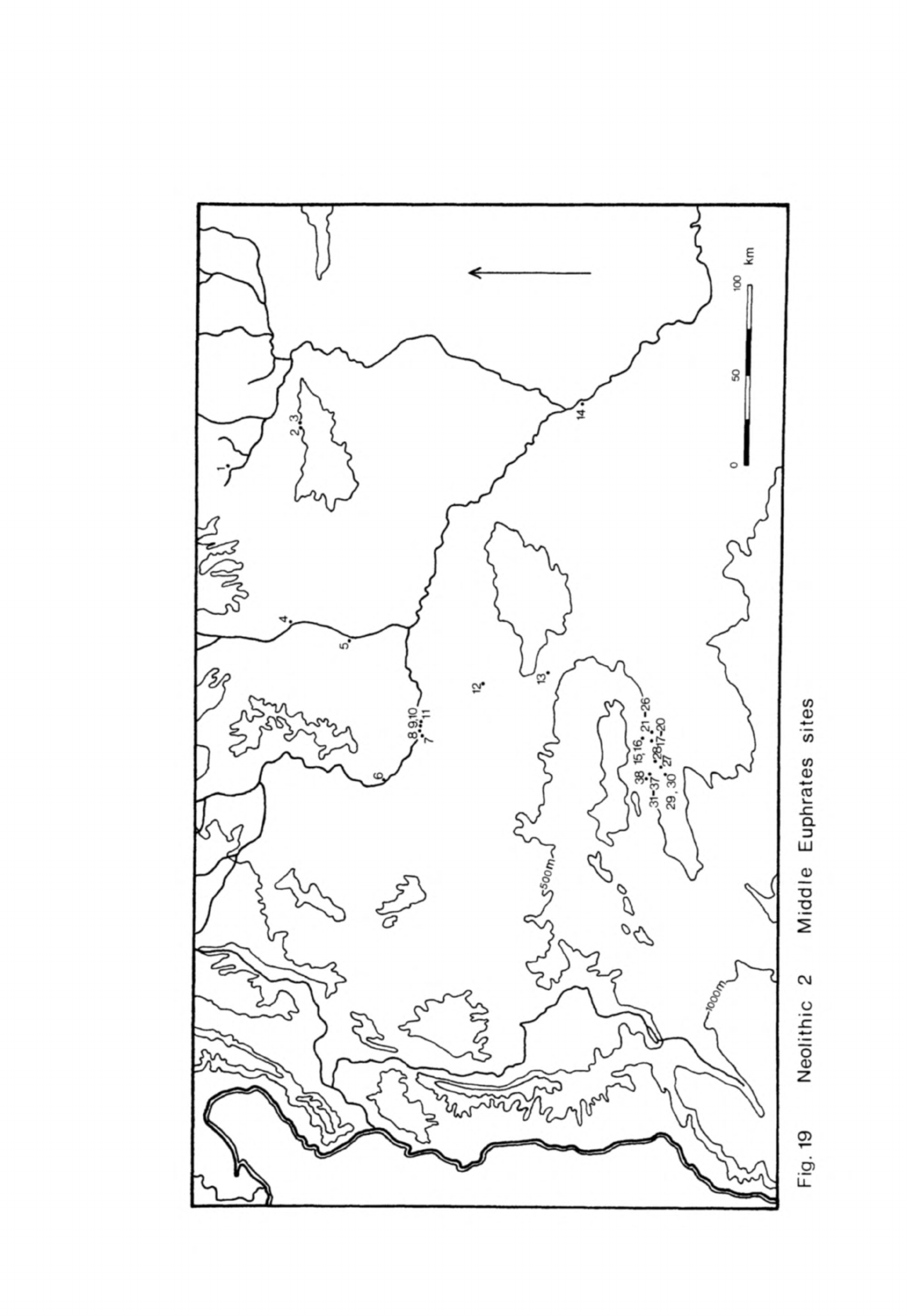
Fig.
19
Neolithic
2
Middle
Euphrates
sites
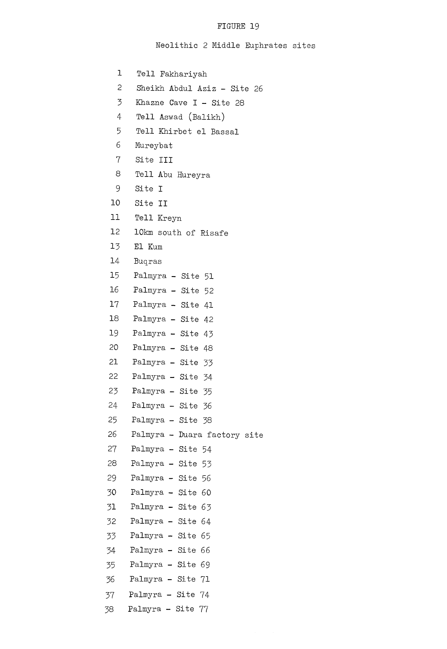
FIGURE
19
Neolithic
2
Middle Euphrates
sites
1
Tell
Fakhariyah
2
Sheikh
Abdul
Aziz
-
Site
26
3
Khazne
Cave
I
-
Site
28
4
Tell
Aswad
(Balikh)
5
Tell
Khirbet
el
Bassal
6
Mureybat
7
Site
III
8
Tell
Abu
Hureyra
9
Site
I
10
Site
II
11
Tell
Kreyn
12
10km
south
of
Risafe
13 El
Kum
14
Buqras
15
Palmyra
-
Site
51
16
Palmyra
-
Site
52
17
Palmyra
-
Site
41
18
Palmyra
-
Site
42
19
Palmyra
-
Site
43
20
Palmyra
-
Site
48
21
Palmyra
-
Site
33
22
Palmyra
-
Site
34
23
Palmyra
-
Site
35
24
Palmyra
-
Site
36
25
Palmyra
-
Site
38
26
Palmyra
-
Duara
factory
site
27
Palmyra
-
Site
54
28
Palmyra
-
Site
53
29
Palmyra
-
Site
56
30
Palmyra
-
Site
60
31
Palmyra
-
Site
63
32
Palmyra
-
Site
64
33
Palmyra
-
Site
65
34
Palmyra
-
Site
66
35
Palmyra
-
Site
69
36
Palmyra
-
Site 71
37
Palmyra
-
Site 74
38
Palmyra
-
Site
77
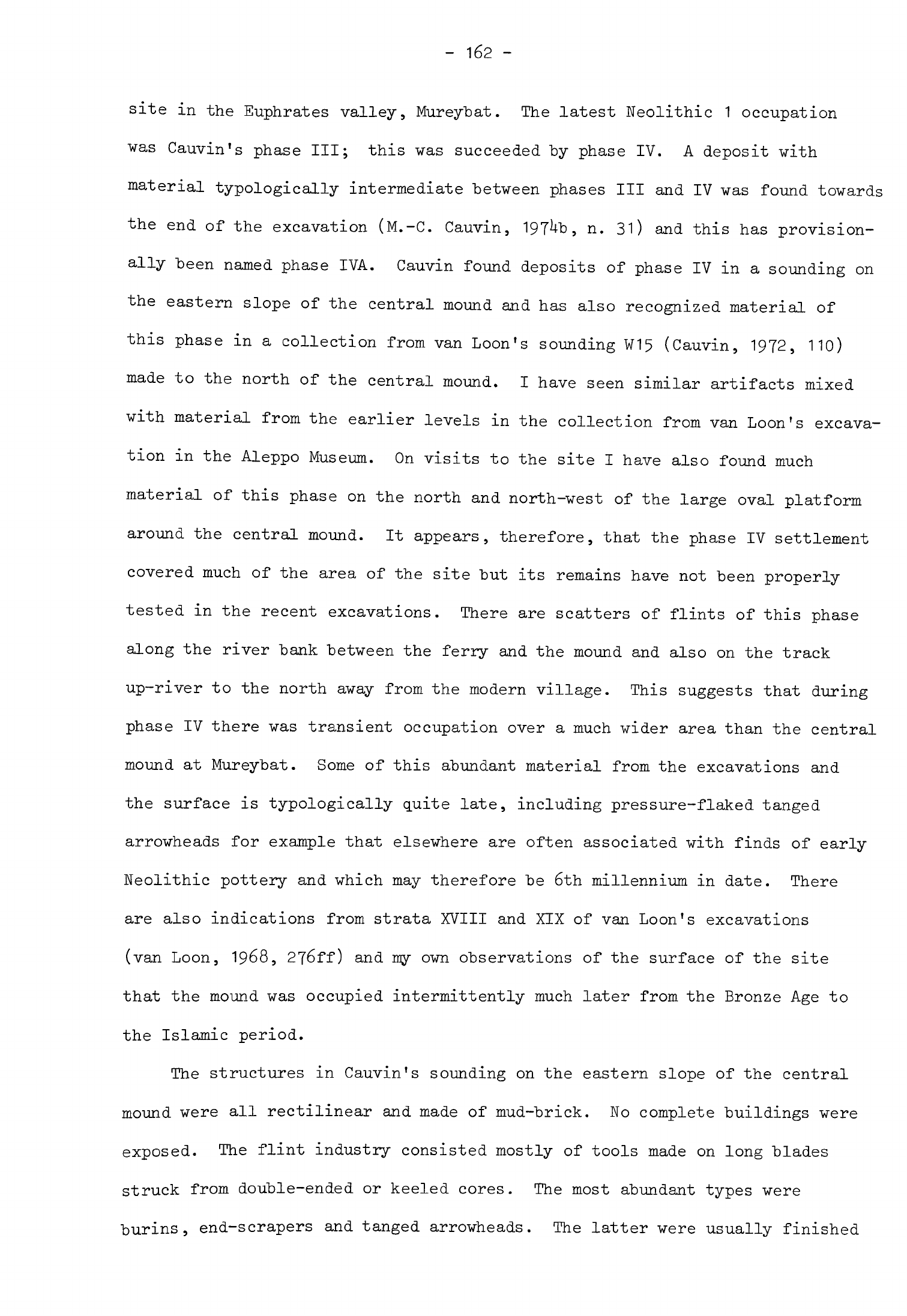
-
162
-
site
in
the
Euphrates
valley, Mureybat.
The latest
Neolithic
1
occupation
was
Cauvin's
phase
III;
this
was
succeeded
by
phase
IV.
A
deposit
with
material
typologically
intermediate
"between
phases
III
and
IV
was
found
towards
the
end
of the
excavation
(M.-C.
Cauvin,
197^b,
n.
31)
and
this
has
provision-
ally
been
named
phase
IVA.
Cauvin
found
deposits
of
phase
IV
in
a
sounding
on
the
eastern
slope
of
the
central
mound
and
has
also
recognized
material
of
this
phase
in
a
collection from
van
Loon's
sounding
W15
(Cauvin,
1972,
110)
made
to
the
north
of the central
mound.
I
have
seen
similar
artifacts
mixed
with
material
from
the
earlier
levels
in
the
collection
from
van
Loon's
excava-
tion
in
the
Aleppo
Museum.
On
visits to
the
site
I
have
also
found
much
material
of
this
phase
on
the
north
and
north-west
of
the
large
oval
platform
around
the
central
mound.
It
appears,
therefore,
that
the
phase
IV
settlement
covered
much
of
the
area
of
the
site
but
its
remains
have
not
been
properly
tested
in
the
recent
excavations.
There
are
scatters
of
flints
of this
phase
along
the
river
bank
between
the
ferry
and the
mound
and
also
on
the
track
up-river
to
the
north
away
from
the
modern
village.
This
suggests
that
during
phase
IV
there
was
transient
occupation
over
a
much
wider
area
than
the
central
mound
at
Mureybat.
Some
of
this
abundant
material
from
the
excavations
and
the
surface
is
typologically
quite
late,
including
pressure-flaked
tanged
arrowheads
for
example
that
elsewhere
are
often
associated
with
finds
of
early
Neolithic
pottery
and
which
may
therefore
be
6th
millennium
in
date.
There
are
also
indications
from
strata
XVIII
and
XIX
of
van
Loon's
excavations
(van
Loon,
1968,
2j6ff)
and my
own
observations
of
the
surface
of
the
site
that the
mound
was
occupied
intermittently
much later
from
the
Bronze
Age
to
the
Islamic
period.
The
structures
in
Cauvin's
sounding
on
the
eastern
slope
of
the
central
mound
were
all
rectilinear
and
made
of
mud-brick.
No
complete
buildings
were
exposed.
The
flint
industry
consisted mostly
of
tools
made
on
long
blades
struck
from
double-ended
or
keeled
cores.
The
most
abundant
types
were
burins,
end-scrapers
and
tanged
arrowheads.
The
latter
were
usually
finished
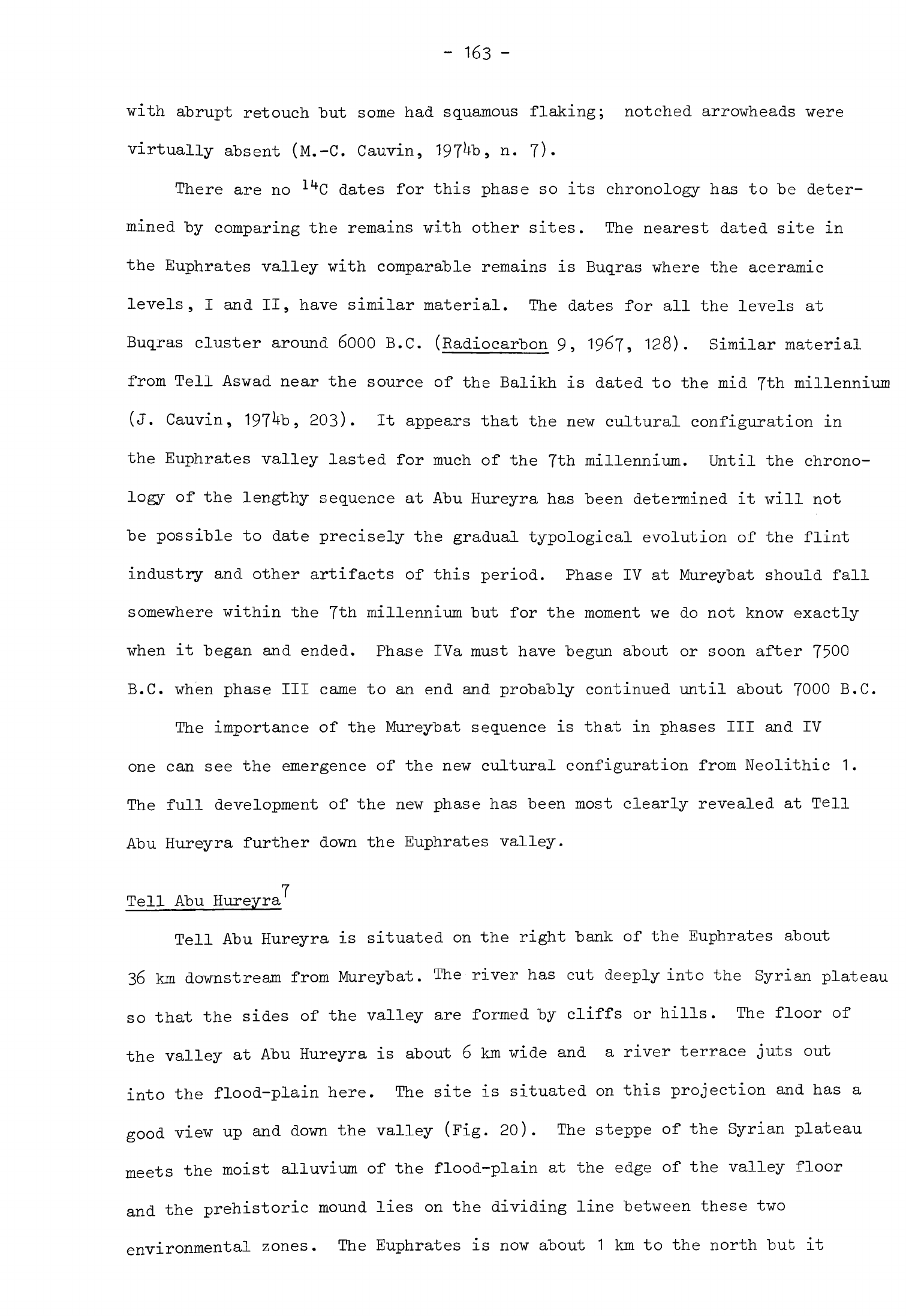
-
163
-
with
abrupt
retouch
"but
some
had
squamous
flaking;
notched
arrowheads
were
virtually
absent
(M.-C.
Cauvin,
197^,
n.
7).
There
are
no
llt
C
dates
for
this
phase
so
its
chronology
has
to
"be
deter-
mined
by
comparing
the
remains
with
other
sites.
The
nearest
dated
site
in
the
Euphrates
valley
with
comparable
remains
is
Buqras
where
the
aceramic
levels,
I
and
II,
have
similar
material.
The
dates
for
all
the levels
at
Buqras
cluster
around
6000
B.C.
(Radiocarbon
9,
19&7,
128).
Similar
material
from
Tell
Aswad
near
the
source
of
the
Balikh
is
dated
to
the
mid
7th
millennium
(J.
Cauvin,
197^b,
203).
It
appears
that
the
new
cultural
configuration
in
the
Euphrates valley
lasted
for
much
of
the
7th
millennium. Until
the
chrono-
logy
of
the
lengthy
sequence
at
Abu
Hureyra
has
been
determined
it
will
not
be
possible
to
date
precisely
the gradual
typological
evolution
of
the
flint
industry
and
other
artifacts
of
this
period.
Phase
IV
at
Mureybat
should
fall
somewhere
within
the
7th
millennium
but
for
the
moment we
do
not
know
exactly
when
it
began
and
ended.
Phase IVa
must
have
begun
about
or
soon
after
7500
B.C.
when
phase
III
came
to
an
end
and
probably
continued
until
about
7000
B.C.
The
importance
of
the
Mureybat
sequence
is
that
in
phases
III
and
IV
one
can see
the
emergence
of
the
new
cultural
configuration
from
Neolithic
1.
The
full
development
of the new
phase
has
been
most
clearly
revealed
at
Tell
Abu
Hureyra
further
down
the
Euphrates
valley.
7
Tell
Abu
Hureyra
Tell
Abu
Hureyra
is
situated
on
the
right
bank
of
the
Euphrates
about
36
km
downstream
from
Mureybat.
The
river
has
cut
deeply
into
the
Syrian
plateau
so
that the
sides
of
the
valley
are
formed
by
cliffs
or
hills.
The
floor
of
the
valley
at
Abu
Hureyra
is
about
6
km
wide
and
a
river
terrace
juts
out
into the
flood-plain
here.
The
site
is
situated
on
this
projection
and has
a
good
view
up and
down
the
valley
(Fig.
20).
The
steppe
of
the
Syrian
plateau
meets
the
moist
alluvium
of
the
flood-plain
at
the edge of
the
valley
floor
and
the
prehistoric
mound
lies
on
the
dividing
line
between
these
two
environmental
zones.
The
Euphrates
is
now
about
1
km
to
the
north
but
it
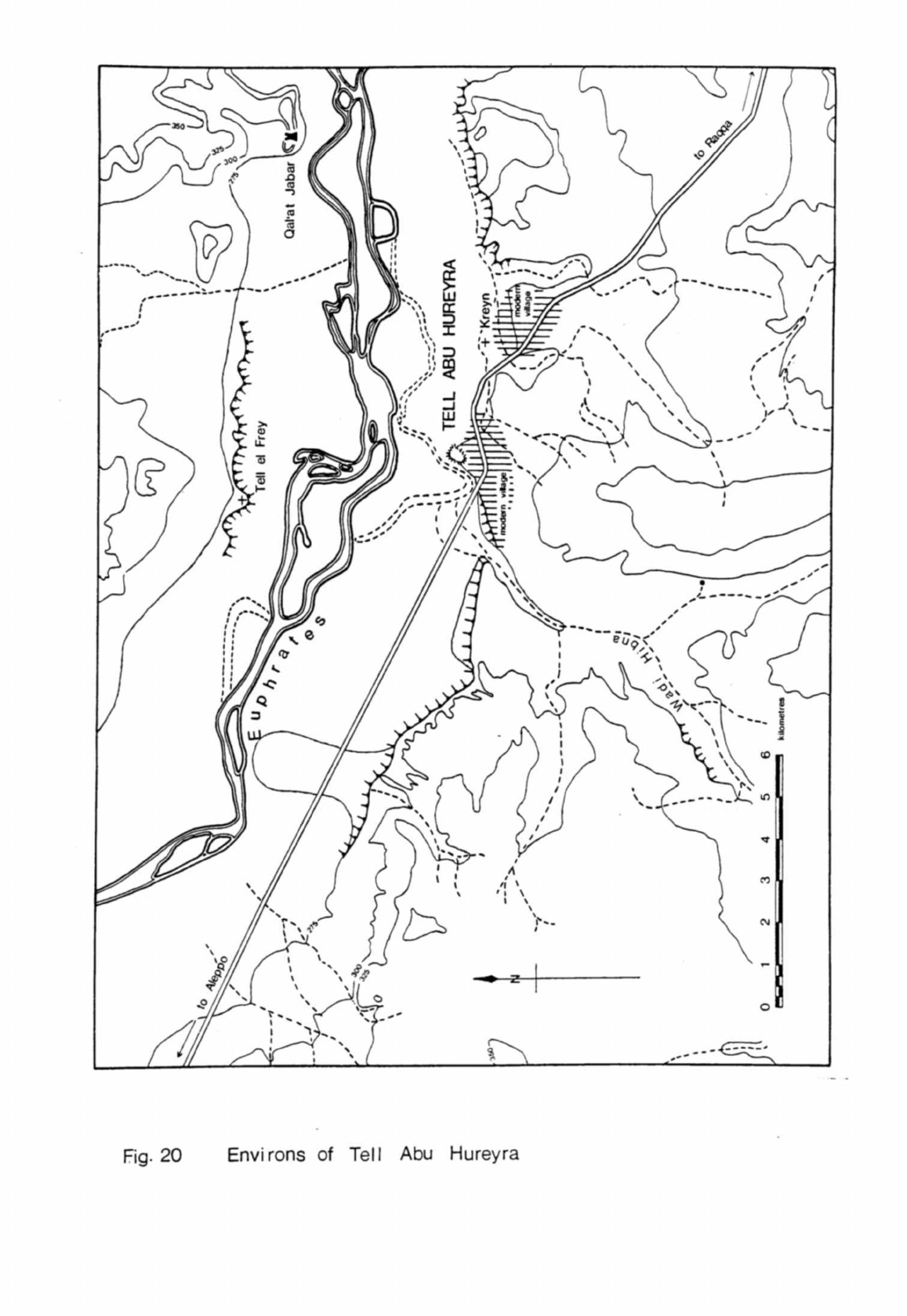
Fig.
20
Environs
of
Tell
Abu
Hureyra
probably
floved
much
nearer
the
site
when
it
was
inhabited
than
now
and
would
have
been
the
main
source
of
water
for the
inhabitants.
An
important
feature
of
the
local
topography
is
the
Wadi
Hibna which
is
incised
into
the
plateau
and
joins
the
Euphrates
valley
2
km
west
of
the
site.
This
area
receives
an
average
of
200
m
rainfall
a
year
although
there
are
considerable
fluctuations
in
the
actual
amount
of
rain that
falls.
Dry
farming
is
possible
on
the
steppe
in
years
when
the
rains
reach
at
least
this
average
figure.
The
water
table
of
the
flood-plain
remains
high
for
much
of
the
year
which
makes
it
possible
regularly
to
obtain
high
crop
yields
today
even
when
the
rains
fail.
The
floor
of
the
Wadi
Hibna
also
has
a
high
water
table
and
is
very
fertile.
Although
the Wadi
is
dry
for
much
of
the
year
now
it
probably
carried
a
perennial
stream
in
the
early
Holocene.
It
was
potential-
ly
important
to
inhabitants
of
the
prehistoric
settlement,
therefore,
because
it
offered
additional
moist
alluvial
land
irrigated
by
running
water.
The
site
which
is
approximately
trapezoidal
in
plan
covers
11.5
ha
(28.5
acres)
and
is
the
largest
known
Neolithic
settlement
in
Syria
(Fig.
21).
A
ridge
runs
from
north
to
south
along the west
side
of
the
site
which
slopes
down
steeply
to
the
flood-plain.
The
north
side
slopes
more
gradually
down
to
the
flood-plain
while
to
the
east
and
south
the
mound
falls
gently
away
to
merge
with
the
terrace.
Almost
all the
debris
of
which
the
mound
is
composed
is
derived
from
the
Neolithic
settlement.
Once
the
Neolithic
settlement
was
founded
it
was
occupied continuously
until
it
was
finally
abandoned.
This
long
occupation
sequence
can
be
con-
veniently
divided
into
three phases,
early
aceramic,
later
aceramic
and
ceramic
Neolithic.
The
first
early
aceramic
deposits
were
found
at
the
bottom
of
trenches
B
and
C
in
the
centre
of
the
north-south
ridge.
This
area
remained
the
focus
of
the
settlement
throughout
its
life
and the
greatest
depth
of
deposit,
8
m,
was
found
here.
The
early
aceramic
village
was
quite
small
but
it
rapidly
expanded
north
and
south
for
remains
of
a
late
stage
of
the
phase
were
found
in
trench
A
and
in
trench
E
where
it
overlay
the
Mesolithic
Fig.
21
Tell
Abu
Hureyra
-
contour
plan
A-G
excavated
trenches
-
165
-
settlement.
In
the
later
aceramic phase
the settlement
grew
still
more
until
it
covered
the
whole
area
of
the mound.
Remains
of this
stage
make
up
almost
all
the
5
m
of
deposit
in
trenches
F
and
G,
both
of
which
were
dug
to
test
the
sequence
of
occupation
of
the
rest
of
the
mound.
The
settlement
later
con-
tracted
in
size
so
that
in
the
ceramic
Neolithic
phase
it
covered
about
half
the
area
of
the
mound.
Occupation
was
confined
to
the
north-south
ridge
where
the
remains
of
this
phase
make
up the
top
metre
of
deposit
in
trenches
A,
B,
C,
and
E.
Originally
this
deposit
would
have been
considerably
deeper
but
much
has
disappeared
through
erosion.
The
buildings were
of
much
the
same
type
throughout
the
aceramic
Neolithic
occupation.
They
were rectilinear
with
several
rooms
and
built
of
mud-brick.
The
rooms
themselves
were
from
3
to
k
m
long
and
from
1.1*
to
2
m
wide.
One
complete
building
excavated
had
five
rooms
and
its
exterior
dimensions
were
10.T
m
by
H.5
m.
The
walls
were
usually
quite
thin
so
these
buildings
were
probably
one
storey
high.
In
one
building
the walls
had
survived
intact
to
their
original
height
of
1.7
m.
There
were
several
vertical
post-holes
set
in
the
tops of
the
walls
to
carry
either
a
loft
or
subsidiary
supports
for the
roof.
In
the
same
building
was
a
rectangular
porthole
doorway
between
two
of
the
rooms
with
a
high
sill
and
mud-brick
lintel.
This
type
of
doorway
seems
to
have
been
the
common
form
of
entry
to
the
rooms
of
these
buildings
although
a
few
had
doors
at
floor
level.
The
rooms
of
these
buildings usually
had
plastered
floors
which
were
coloured
black
and
then
burnished.
A
few
had
designs
painted
on
them
in
red,
one
of
which
was
recognizable
as
a
sunburst,
a
blob
with
lines
radiating
from
it.
Some
had
simple
trodden
earth
floors.
The
walls
were
covered
with
mud
plaster
which
in
some
buildings
had
been
whitewashed.
A
few
buildings
had
internal
features
made
of
mud-brick
and
plaster.
There
were
low
platforms
in
the
corners
of
some
rooms
which
may
have
been
for
sitting
or
sleeping
on.
Storage
bins
were
found
in
a
room
of
at
least
one
building;
these
were
made
of
mud-brick
and
lined
with
plaster.
Niches
were
frequently
built
into
walls
and
probably
served
as
receptacles
for
household
-
166
-
equipment.
A
number
of
buildings
had
a
hearth
in
the centre of
a
room.
This
was
filled
with
ashes
but
the
rest
of
the
room
was
often
quite
clean
so
I
am
inclined
to
think
the
hearths
were
used
for
warmth
and
light
rather
than
for
cooking.
A
room
of
one
building
had
a
clay oven
in
one
corner
which
was
almost
certainly
used
for
preparing
food.
Most
of
these
buildings
had
much
the
same
characteristics
and
were probably
houses.
One
structure
in
trench
G
had
a
different
plan.
It
consisted
of
two
rooms
of
the
usual shape
but
adjoining
these
was
a
pair
of
narrow
chambers,
0.5
and
1
m
wide
and
at
least
h
m
long.
This
building
may
have
been
used
for
some
other
purpose.
Although
each
house
was
separated
from
its
neighbours
all
were
built
close
together
with
only
narrow
lanes
and
courts
between
them.
This
density
was
so
marked
that we
found
remains
of
one
and
even
two
or
three
series
of
buildings
in
every
trench we
excavated.
The
buildings
themselves
were
quite
often
clean
inside
with
just
a
scatter
of
flint
tools
or
other
artifacts
on
the
floors.
The
passageways
outside
were
choked
with
organic
refuse,
animal
bones,
ashes
and the
remains
of
fires.
It
would
appear
that
meat
in
particular
was
prepared
outside
and
that
domestic
rubbish
was
allowed
to
accumulate
between
the
buildings.
All
these
buildings
faced
south
or
south-west
to
catch
the
winter
sun.
They
were
rebuilt time
after
time
on
the
same
alignment
in
the
same
place.
In
trench
B
this
happened
seven
and
in
trench
C
no
less
than
eleven
times.
Two
possible
explanations
may
be
offered
for this
practice.
One
is
that
the
restrictions
on
space
within
the
settlement
were
so
great
that
a
new
building
had
to
be
constructed
on
the
same
plot
as
its
predecessor.
The
other
might
be
that
families
had
customary
rights
to
certain
plots
and
chose
to
rebuild
their
dwellings
on
the
same spot
over
many
generations.
In
practice
these two
influences
probably operated
together,
the
result
being
that
the
same
arrange-
ment
of
houses
was
perpetuated
over
a
long
period,
itself
an
indication
of
the
stability
of
the
settlement.
The
ceramic
Neolithic
layers
had weathered
badly
so
that
it
was not
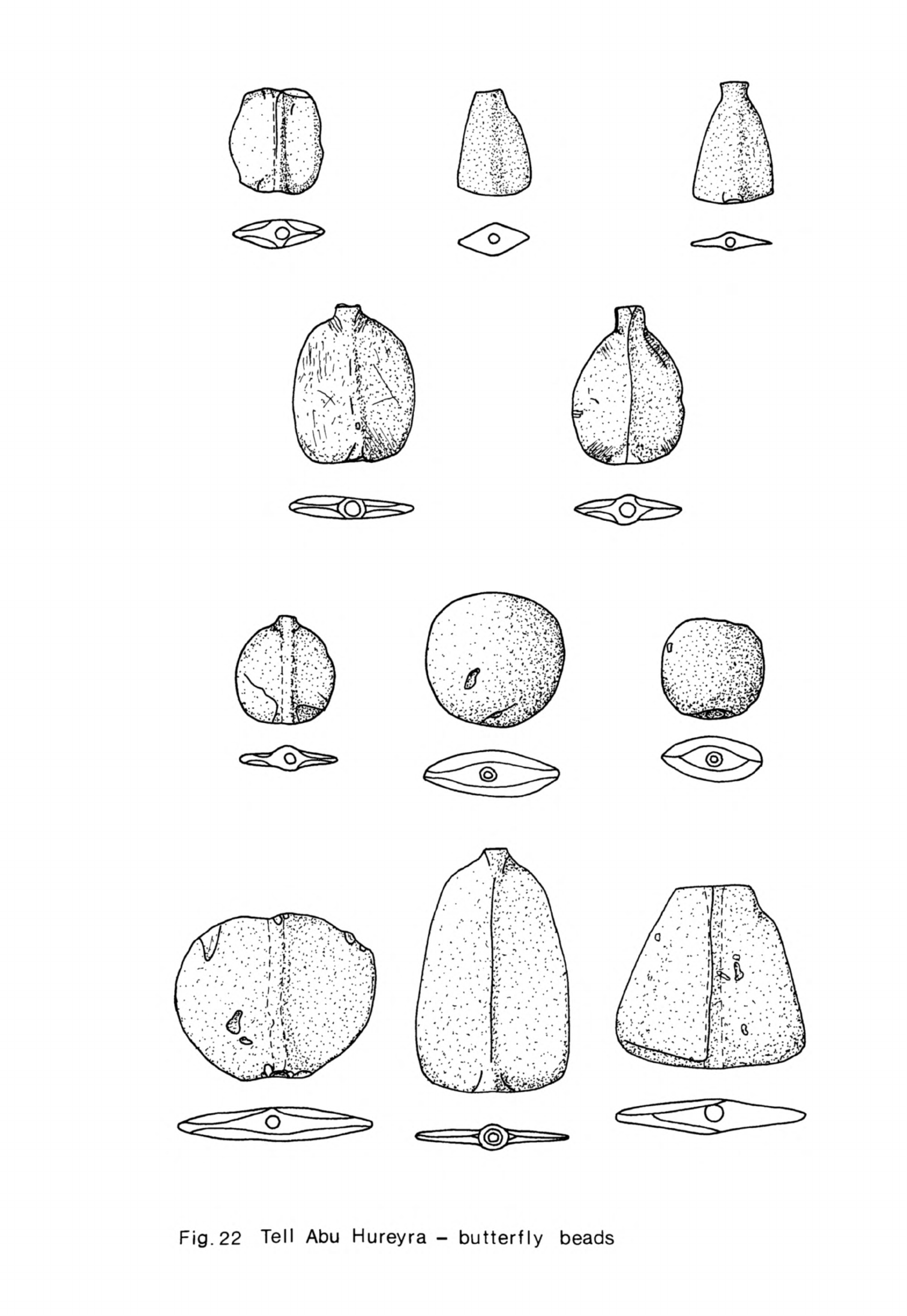
Fig.
22
Tell
Abu
Hureyra
-
butterfly
beads
-
167
-
possible
to
determine
the
plans
of
any
"buildings.
Traces
of
rectilinear
mud-brick
structures
were
found,
enough
to
indicate
that
the
same
building
tradition
continued.
A
new
feature
characteristic
of
these
layers
was
a
series
of
shallow
pits
up
to
2
m
in
diameter
and
1
m
deep.
Some
had
been
dug
out
and reused
many
times.
Each
was
filled
with
burned
debris,
bones and
often
stones
as
well.
They
may
have
been
roasting
pits or
fire
hollows
but
their
exact
purpose
is
uncertain
for
the
moment.
Throughout
the
life of
the
Neolithic
settlement
the
inhabitants
buried
their
dead
in
shallow
pits
beneath
the
floors
of
their
houses
or
in
the yards
outside.
Some
bodies
were
buried
singly
in a
crouched
position though
the
skull
was
sometimes
removed.
A
few of
these
had
been
wrapped
in
matting.
One
had
a
flint
arrowhead
lodged
in
the
chest
cavity,
evidence
that this
individual
had
suffered
a
violent
death.
Other
corpses
were
buried
in
groups
either
with
or
without
their
skulls.
The
skulls
were
deposited
singly
or
in
groups,
sometimes
mixed
with
a
few
other
human
bones. The
single
inhumations
were
best
preserved
because
they
had
not
been
subsequently
disturbed.
The
multiple
burials
were
often
disordered;
skeletons
were
frequently
buried
incomplete
and
the
bones
were
in
poor
condition.
This
was
because
secondary
burial
had
taken
place.
The
bodies
seem
to
have
been
buried
until
the
flesh
had
decayed
and
later
exhumed.
The
skulls
were
often
then detached
and
buried
separately while
the
remaining
bones
were
carelessly
gathered
up
and
reburied
in
multiple
graves.
Red
ochre
was
scattered
over
some of
the
bodies
and
painted
on
several
of
the
skulls.
A
few
of the
burials
were
accompanied
with
grave
goods,
one
or
two
river
pebbles,
a
flint
tool
or
some
beads.
In
one
case
a
complete
necklace
of
coloured
stone
cylindrical
beads
was
found.
One
unusual
type
of
funerary
artifact
was
the
butterfly
bead
(Fig.
22),
almost
all
of
which
were
found
in
graves.
These
were
oval,
triangular
or
trapezoidal
and
ground
very
thin.
Each
was
bored
through
the
middle
for
suspension.
Most
were
made
of
serpentine
although
a
few
were
cut
from
agate,
both
of
which
were probably
obtained
from
the
Taurus
Mountains.
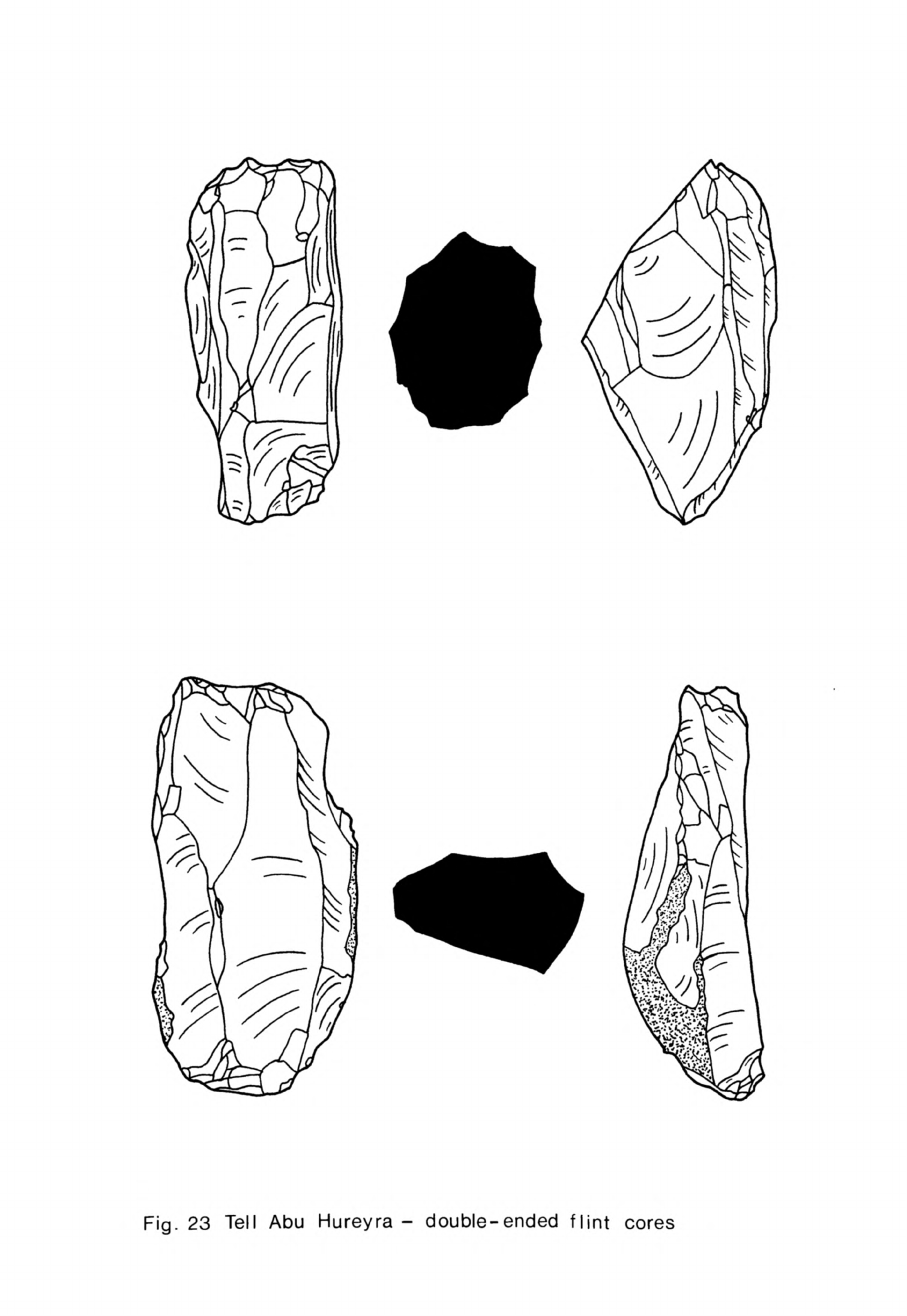
Fig.
23
Tell
Abu
Hureyra-
double-ended
flint
cores
-
168
-
The
skeletons
are
now
"being
examined
in
the
laboratory
and
this
study
promises
to
tell
us
much
about
the
physical
condition
of
the
inhabitants.
It
may
also
be
possible
to
deduce
more precise
information
about
the
compo-
sition
of
families
and
their
social
arrangements.
One
problem
in
particular
on
which
the
anthropological
study
may
throw
some
light
is
the
question
of
family
ownership
of
houses and
their
rebuilding
over
several
generations.
If
burials
of
the
descendants
of
a
single
family
are
found
beneath
successive
houses
that
could
be
an
indication
that
ownership
of
dwellings
and
the
plot
on
which
they
stood
was
maintained
within
the
same
family
from
one
generation
to
the
next.
The
flint
industry
was
based
upon the
production
of
large
blades
from
conical and
double-ended
cores.
All
the
flint
was
obtained
in
the
vicinity
from
wadi
gravels,
the
valley
slopes
and
outcrops
in
the
limestone.
There
were
some
gradual
alterations
in
the
techniques
of
production
and
in
the
types
of
tools
found
during
the
life of
the
settlement
which
help
to
differentiate
the
phases.
In the
early
aceramic
the
blades
were
long,
irregular
and
pointed.
During
the next
two
phases
most
blades
were
struck
from
double-ended
cores
(Fig. 23)
and
as
a
result
were
parallel-sided
and
more
regular.
Relatively
few
types
of
tools
were
made
in
the
early
aceramic;
tanged
arrowheads,
end-scrapers
and borers
on
blades,
single-blow
and
angle
burins
together
with
a
few
flake
scrapers.
Massive
flint
tools
were
not
found
at
Abu
Hureyra
nor
are
they
known
from
any
other
site
in
the
Levant
occupied
at
this
time.
These
tools
were
shaped with
a
little
abrupt
retouch,
the
arrowheads
sometimes
being
retouched
under
the
tip
as
well
as
around
the
tang.
Arrowheads
were
by
far
the
most
common
tool
throughout
the
Abu
Hureyra
sequence
(Figs.
2k
9
25).
Tools
were
retouched
a
little more
in
the
later
aceramic
phase
and
squamous
pressure-flaking
was
introduced.
A
greater
variety
of
scrapers
was
made
(Fig.
26),
among
them
side-scrapers
on
flakes
and
blades
and
disc
scrapers
The
smaller
discoids
or
thumbnail
scrapers
are
quite
characteristic
of
the

Fig.
24
Tell
Abu
Hureyra
-
flint
arrowheads
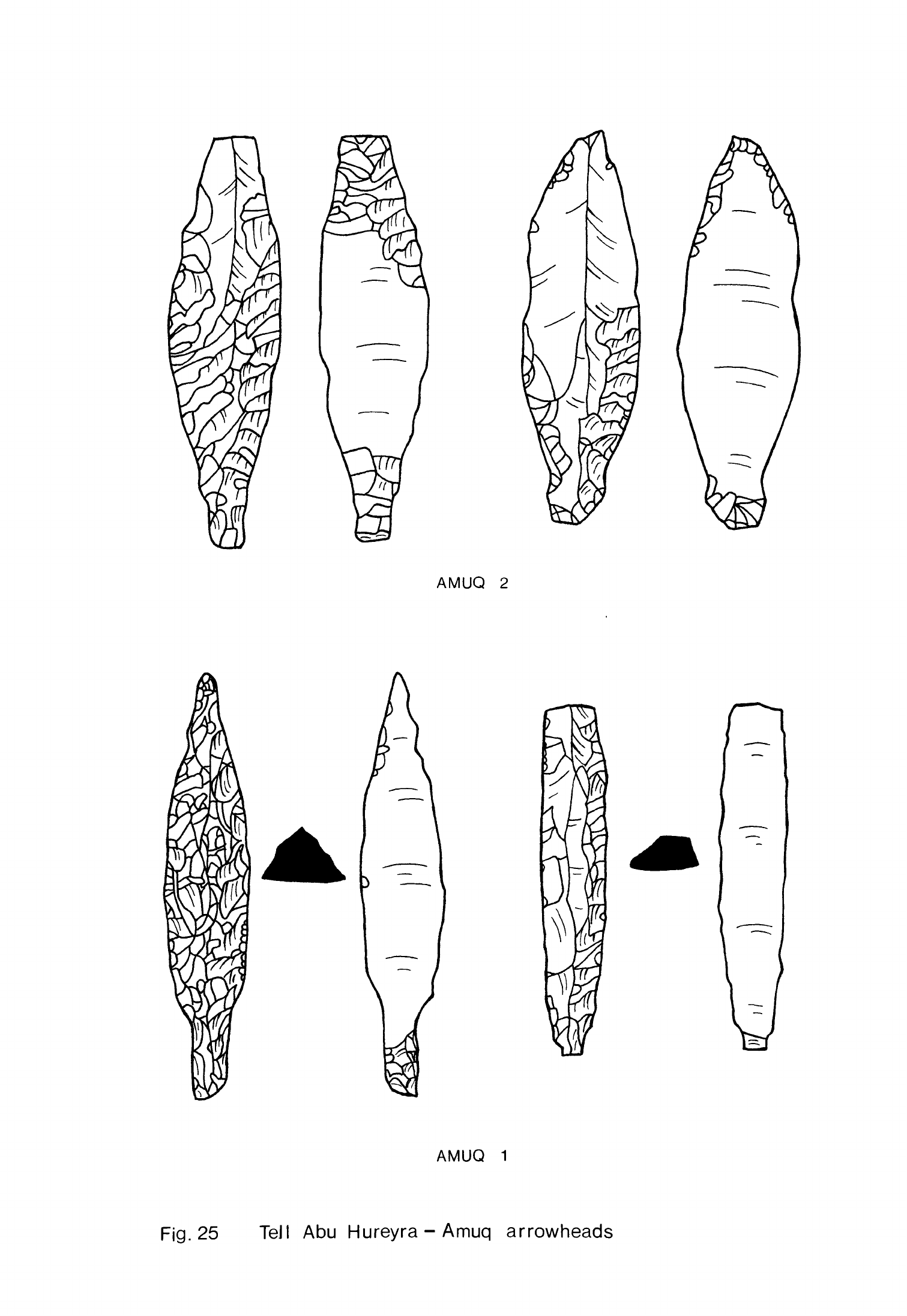
AMUQ
2
\
AMUQ
1
Fig.
25
TeJI
Abu
Hureyra-Amuq
arrowheads
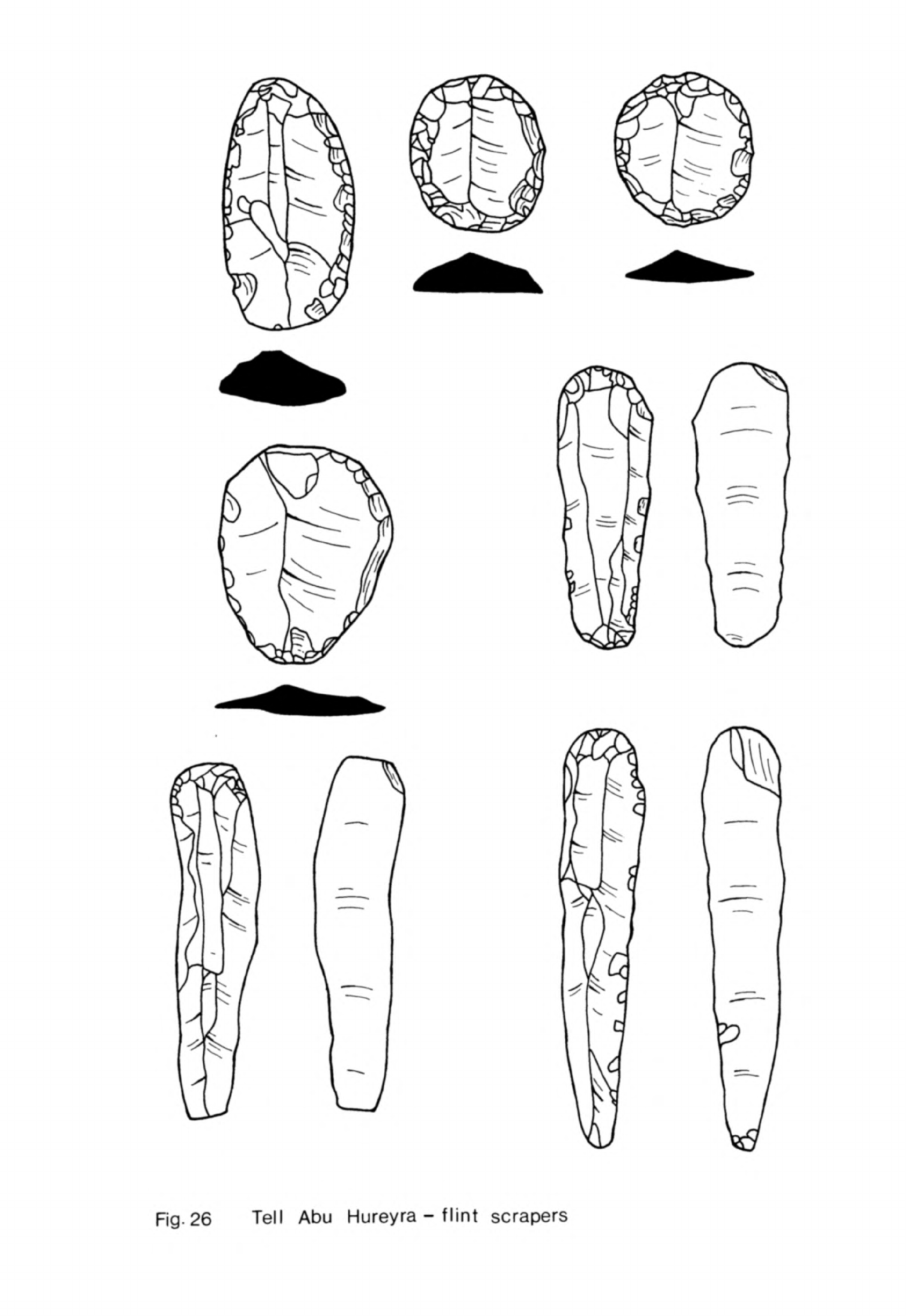
Fig.
26
Tell
Abu
Hureyra
-
flint
scrapers
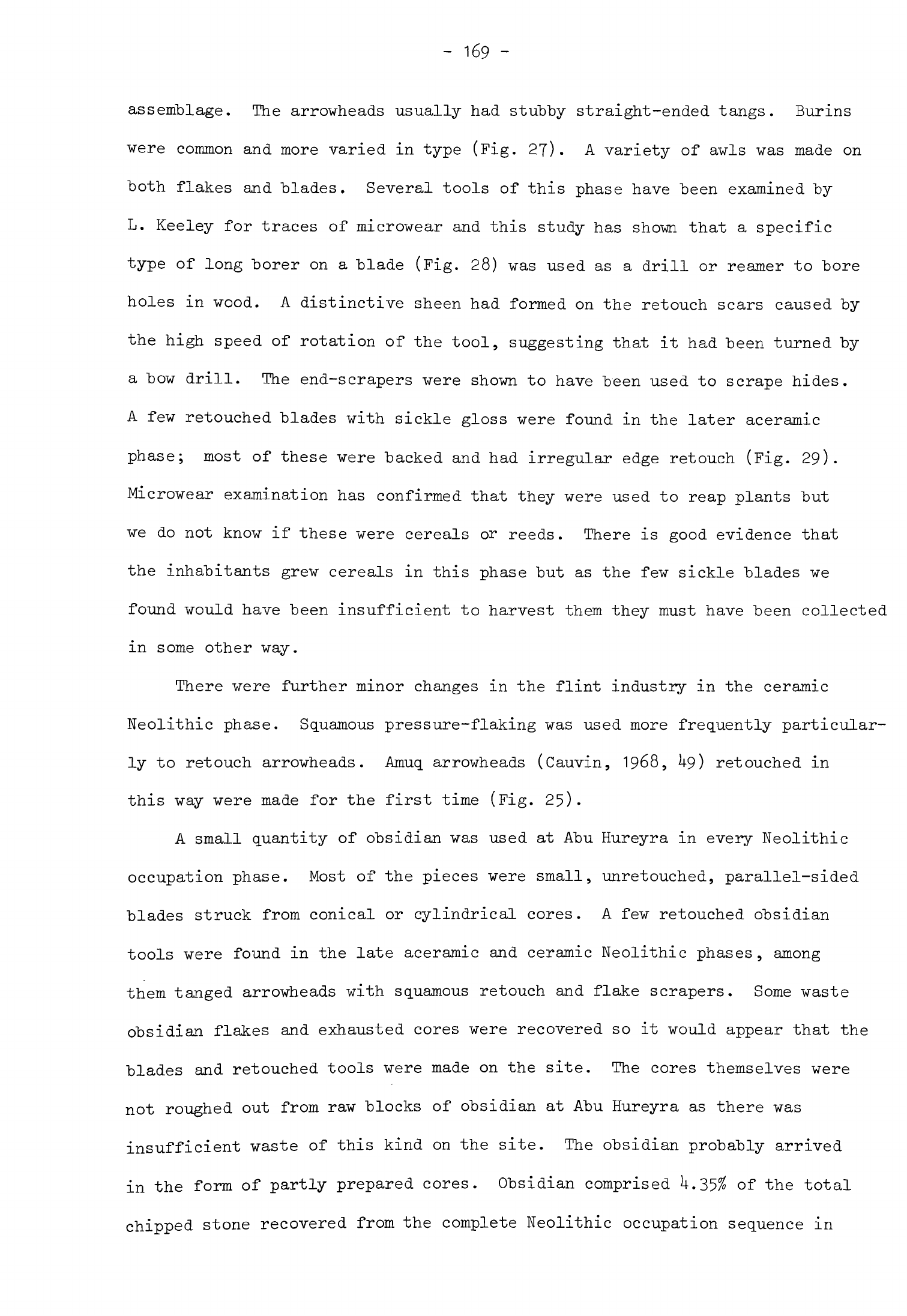
-
169
-
assemblage.
The
arrowheads
usually
had
stubby
straight-ended
tangs.
Burins
were
common
and
more
varied
in
type
(Fig.
27).
A
variety
of
awls
was
made
on
both
flakes
and
"blades.
Several
tools
of this
phase
have
been
examined
by
L.
Keeley
for
traces
of
microwear
and
this
study
has
shown
that
a
specific
type
of
long
borer
on
a
blade
(Fig.
28)
was
used
as
a
drill
or
reamer
to
bore
holes
in
wood.
A
distinctive
sheen
had
formed
on
the
retouch
scars
caused
by
the
high
speed
of
rotation
of
the
tool,
suggesting
that
it
had
been
turned
by
a
bow
drill. The
end-scrapers
were
shown
to
have
been used
to
scrape
hides.
A
few
retouched
blades
with
sickle
gloss
were
found
in
the
later
aceramic
phase;
most
of
these
were
backed
and
had
irregular
edge
retouch
(Fig.
29).
Microwear
examination
has
confirmed
that
they
were used
to
reap
plants
but
we
do
not
know
if
these
were
cereals
or
reeds.
There
is
good
evidence
that
the
inhabitants
grew
cereals
in
this
phase but
as
the few
sickle
blades
we
found
would
have
been
insufficient
to
harvest
them they
must
have
been
collected
in
some
other
way.
There
were
further
minor
changes
in
the
flint
industry
in
the
ceramic
Neolithic
phase.
Squamous
pressure-flaking
was
used
more
frequently
particular-
ly to
retouch
arrowheads.
Amuq
arrowheads
(Cauvin,
1968,
U9)
retouched
in
this
way were
made
for
the
first
time
(Fig.
25).
A
small
quantity
of
obsidian
was
used
at
Abu
Hureyra
in
every
Neolithic
occupation
phase.
Most
of
the
pieces
were
small,
unretouched,
parallel-sided
blades
struck
from
conical
or
cylindrical
cores.
A
few
retouched
obsidian
tools
were
found
in
the
late
aceramic
and
ceramic
Neolithic
phases,
among
them
tanged
arrowheads
with
squamous
retouch
and
flake scrapers.
Some
waste
obsidian
flakes
and
exhausted
cores
were
recovered
so
it
would
appear
that
the
blades
and
retouched
tools
were
made
on
the
site.
The
cores
themselves
were
not
roughed
out
from
raw
blocks
of
obsidian
at
Abu
Hureyra
as
there
was
insufficient waste
of
this
kind
on
the
site.
The
obsidian
probably
arrived
in
the
form
of
partly
prepared
cores.
Obsidian
comprised
U.35%
of
the
total
chipped
stone
recovered
from
the
complete
Neolithic
occupation
sequence
in
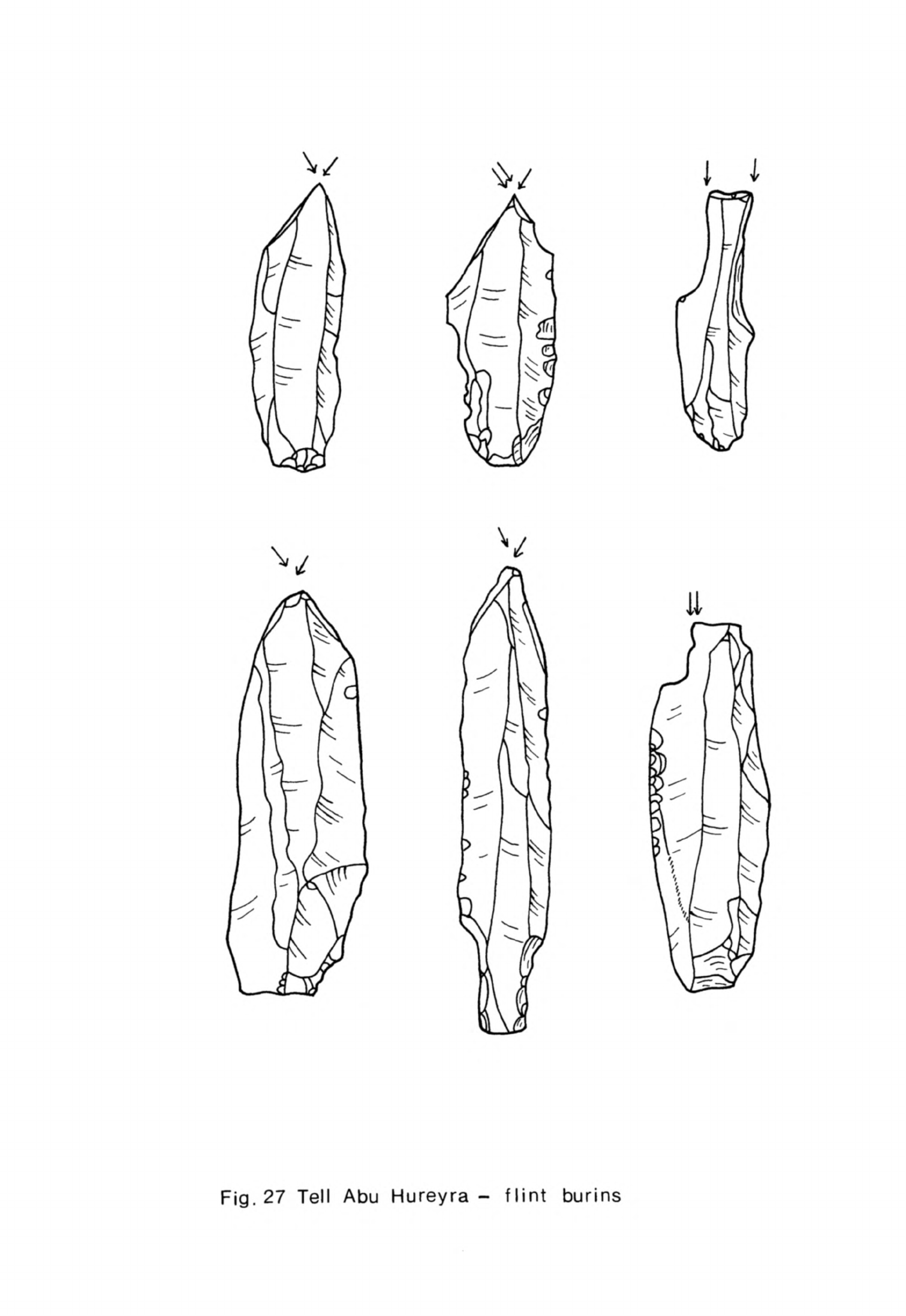
\
Fig.
27
Tell
Abu
Hureyra
-
flint
burins
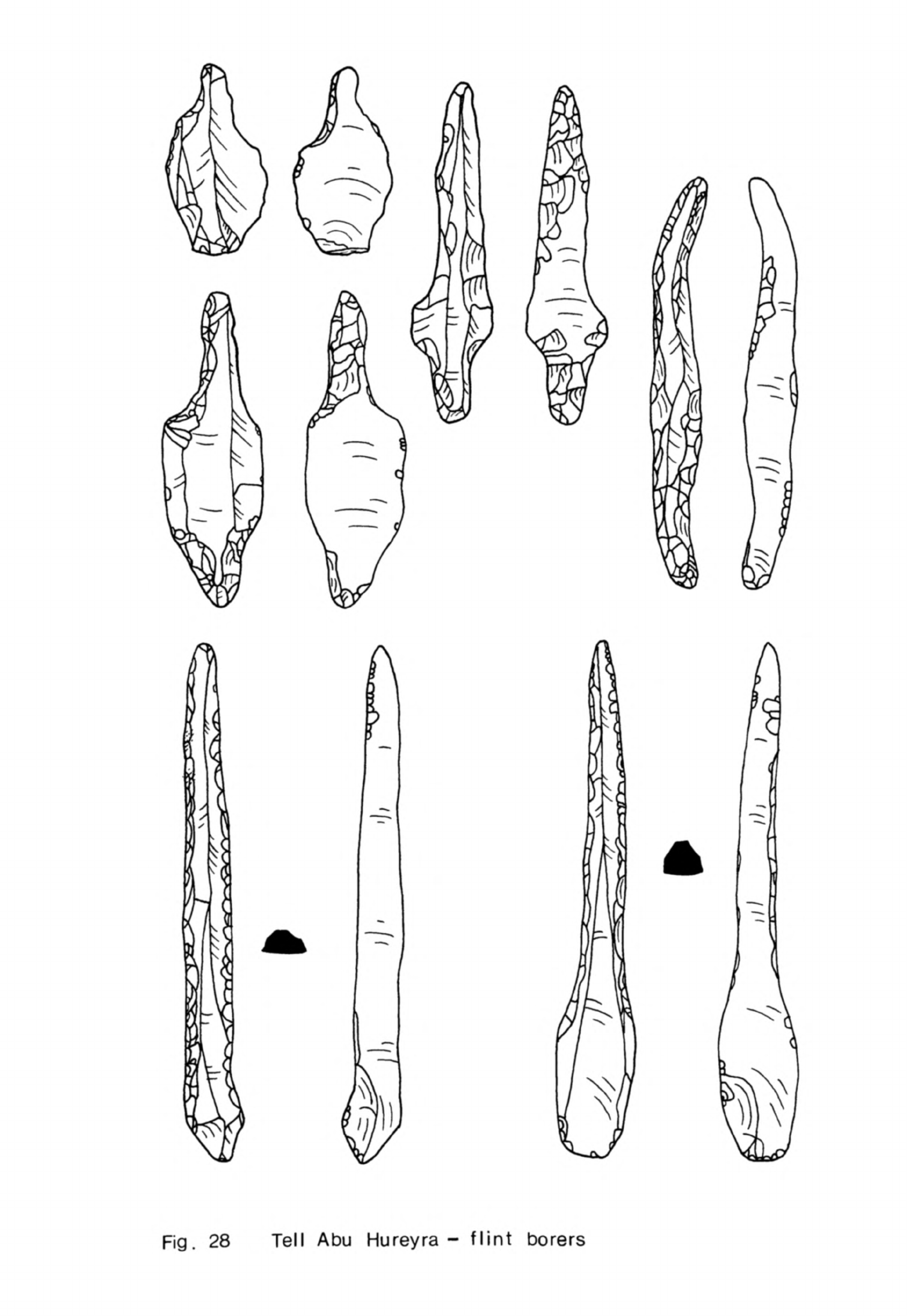
Fig.
28
Tell
Abu
Hureyra-
flint
borers
V
Fig.
29
Tell
Abu
Hureyra
-
flint
sickle
blades
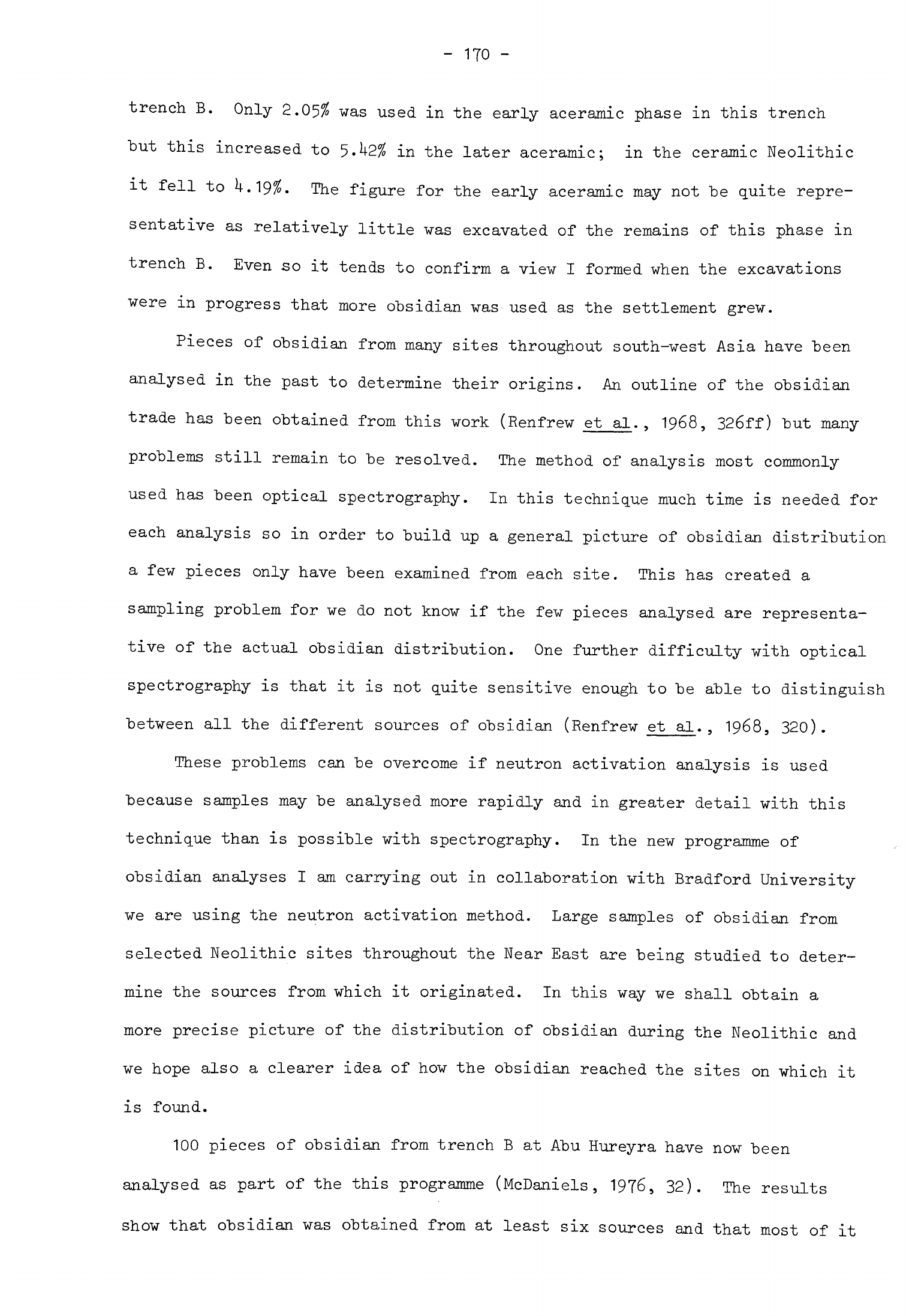
-
170
-
trench
B.
Only
2.05%
was
used
in
the
early
aceramic phase
in
this
trench
"but
this
increased
to 5.k2%
in
the
later
aceramic;
in
the
ceramic
Neolithic
it
fell
to U.19%. The
figure
for
the
early aceramic
may
not
"be
quite
repre-
sentative
as
relatively
little
was
excavated
of the
remains
of this
phase
in
trench
B.
Even
so
it
tends
to
confirm
a
view
I
formed
when
the
excavations
were
in
progress
that
more
obsidian
was
used
as
the
settlement
grew.
Pieces
of
obsidian
from many
sites
throughout
south-west
Asia
have
"been
analysed
in
the
past
to
determine their
origins.
An
outline
of
the
obsidian
trade
has
been
obtained
from
this
work
(Renfrew
et
al.,
1968,
326ff)
but
many
problems
still
remain
to
be
resolved.
The
method
of
analysis
most commonly
used
has
been
optical
spectrography.
In
this
technique
much
time
is
needed
for
each
analysis
so
in
order
to
build
up
a
general picture
of
obsidian
distribution
a
few pieces
only
have
been
examined
from
each
site.
This
has
created
a
sampling
problem
for
we
do
not
know
if
the
few
pieces
analysed
are
representa-
tive
of
the
actual
obsidian
distribution.
One
further
difficulty
with
optical
spectrography
is
that
it is
not
quite
sensitive
enough
to be
able
to
distinguish
between
all
the
different
sources
of
obsidian
(Renfrew
et
al.
,
1968,
320).
These
problems
can
be
overcome
if
neutron
activation
analysis
is
used
because
samples
may
be
analysed
more
rapidly
and
in
greater
detail
with
this
technique than
is
possible
with
spectrography.
In
the
new programme
of
obsidian
analyses
I
am
carrying
out
in
collaboration
with
Bradford University
we
are
using
the
neutron
activation
method.
Large
samples
of
obsidian
from
selected
Neolithic
sites
throughout
the
Near
East
are
being
studied
to deter-
mine
the
sources
from
which
it
originated.
In
this
way
we shall
obtain
a
more
precise picture
of the
distribution
of
obsidian
during
the
Neolithic
and
we
hope
also
a
clearer idea
of
how
the
obsidian
reached
the
sites
on
which
it
is
found.
100
pieces
of
obsidian
from
trench
B
at
Abu
Hureyra
have
now
been
analysed
as
part
of
the
this
programme
(McDaniels,
1976,
32).
The
results
show
that
obsidian
was
obtained
from
at
least
six
sources
and that
most
of
it
-
171
-
came
from
four of
these
(Table
1).
Obsidian from
Nemrut
Dag
was
favoured
in
the early
aceramic
but
the
proportion
of
obsidian
from
this
source
declined
sharply
later
on.
Relatively
little
obsidian
was
obtained
at
first
from
the
Ig
source
which
is
also
believed
to
be
near
Lake
Van
but
much more
was
used
in
the
later
aceramic
and
ceramic
Neolithic
phases.
It
would
thus
appear
that
the proportions
of
obsidian
from
these
two
possibly
neighbouring
sources
varied
inversely.
Some
obsidian from
the
Ciftlik
source was
used
in
the
early
aceramic
but the
proportion
declined
in
the
later
aceramic;
it
increased
markedly
in
the
ceramic
Neolithic
when
it
was the
most
favoured
of
all
the
sources.
Abu
Hureyra
is
equidistant
from
the
£iftlik
and
Vannic
sources
both
about
hQO
km
away.
We
do
not
yet
know
if
these
results
are
truly
representative
of
the use
of
obsidian
at
Abu
Hureyra
as
the
sample
studied
is
still
a
small
one
and
came
from
a
single
trench.
We
propose
to carry
out
a
similar
series
of
analyses
of
obsidian from
trench
C,
another
trench
with
the
full
Neolithic
occupation
sequence,
to see
if
it
supports
the
results
obtained
from
trench
B.
We
can
be
certain,
however,
that
obsidian
from
at
least
six
sources
was
reaching
Abu
Hureyra
and
that
different
amounts
of
obsidian
from
these
sources
were
used
in
each
phase
of
occupation.
Bone
tools
were
the
second
most
common
find
at
Abu
Hureyra
(Fig.
30).
Those
from
the
early
aceramic
were
limited
in
type,
consisting
almost
entirely
of
a
range
of
borers.
The same
borers
were
found
in
the
later
phases
but
there
was
greater
variety:
some
had
fine,
thin
shafts,
others
more
robust
stubby
points.
Spatulae
were
also
quite
common
while
among
the
rarer
items
were
several
bone
needles,
bone
tubes
which
were
sectioned
to
make
beads,
a
fish-hook
and
a
hook
and
eye,
perhaps
used
to secure
clothing.
The
range
is
sufficiently
wide
to
indicate
that
bone
tools
were
used
for
many
crafts
and
domestic
tasks
as
well
as
for
adornment,
at
least
in
the
later
phases
of
occupation.
Several
other
classes
of
artifacts
such
as
pecked
and
polished
greenstone
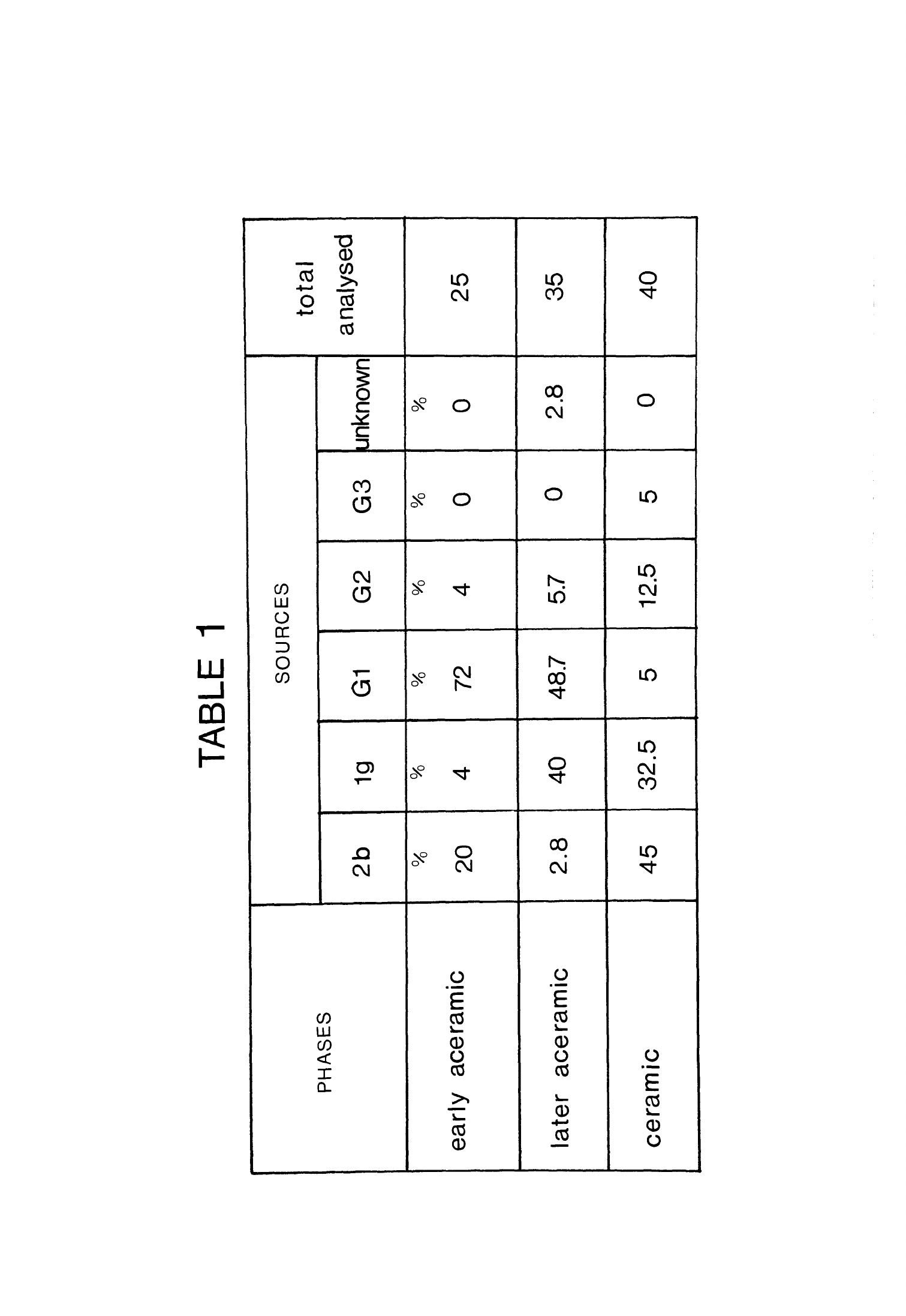
TABLE
1
PHASES
early
aceramic
later
aceramic
ceramic
SOURCES
2b
20
2.8
45
19
4
40
32.5
G1
72
48.7
5
G2
4
5.7
12.5
G3
0
0
5
unknown
0
2.8
0
total
analysed
25
35
40
TABLE
1
Percentages
of
obsidian
in
each
cultural
phase
at
Tell
Abu
Hureyra
Sources:
2b
=
giftlik
(Renfrew
et
al,
1966,
33)
Ig
=
presumed
to
be
near
Lake
Van
(Renfrew
et
al,
1966,
40)
Gl
=
Nemrut
Dag,
source
4c
(Renfrew
et
al,
1966,
34)
G2
=
Bingo'1,
source
4c
(Renfrew
et
al,
1968,
320)
G3 =
believed
to
be
in
eastern
Anatolia
(McDaniels,
1976,
67)
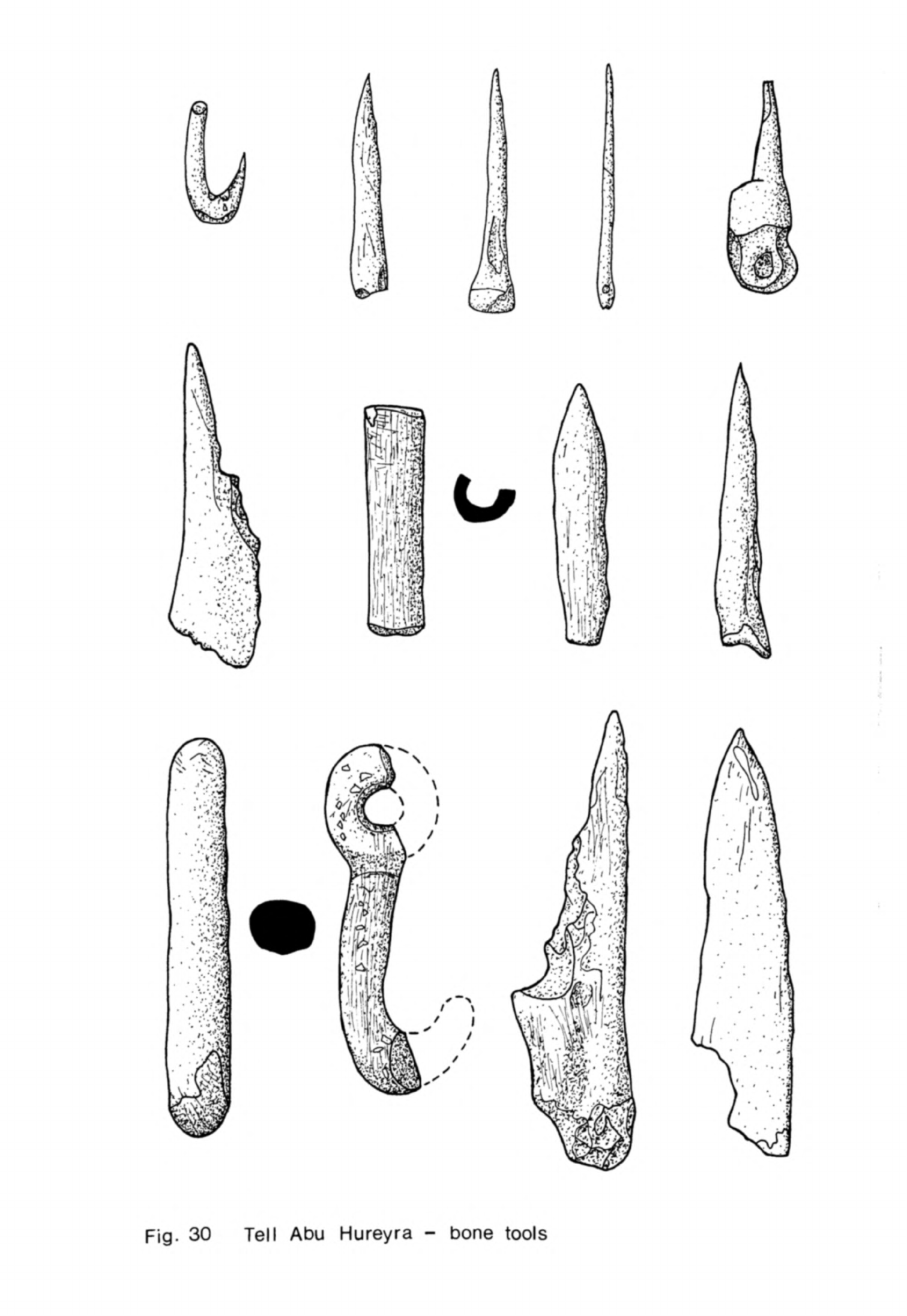
•n
(5*
CD
cr
c
c
-1
CD
•<
^
0)
I
cr
o
3
CD
O
O
C

-
172
-
axes
and
chisels
were
found
throughout
the
occupation
sequence
(Fig.
31)
Most
of
these
were
made
from
pebbles
obtained from
the
river
gravels
but
a
few
were
fashioned
in
jadeite,
almost
certainly
obtained
from
Anatolia.
They
were
probably
used
as
carpentry
tools.
Pecked
stone
balls,
hog-backed
rubbers
and
saddle
querns
were
also
quite
common.
The
rubbers
and
querns
were
made
of
basalt
or
limestone.
A
much
greater
variety
of
artifacts
was
used
in
the
later
aceramic
and
ceramic
Neolithic
phases,
one
of
the
distinguishing
features
of
these
stages
of
settlement.
Some of
the
more
attractive
artifacts
were
a
series of
polished
stone
bowls
and
dishes
(Moore,
1975,
fig.
8).
Most
were
carved
from
coloured
limestones
or
alabaster,
a
few
from
gypsum
and
one
or
two
from
granite
and
steatite. The
bowls
were
usually
hemispherical
and
quite
small
although
a
few
had
flat
bottoms
with
flared
sides.
The
dishes
were
both
round
and
oval.
These
vessels
were
delicately
finished
but
a
series
of
large,
rough stone
bowls
was also
found
which
could
have
been
either
containers
or
mortars.
A
number
of
much
larger
containers
were
made
of
a
distinctive
white
plaster; these
were
similar
to
the
white
ware
(vaisselle
blanche)
found
on
other
contemporary
sites
in
Syria
and
Lebanon.
Several
were
large
rectangular
tubs
with
a
hole-mouth
at
the
top
while
others
were
circular
jars.
Some
had
been
made
in
the rooms
in
which
they
were
found
and
all
were
thick-walled and
very
heavy.
Most
of
the
white
plaster
vessels
were
found
in
the
later
aceramic
Neolithic
layers.
Decorative
items
such
as
beads
and
pendants
were
also
much more
common
in
these
two
phases.
The
variety
of
shapes
was
considerable,
including
cylindrical,
annular,
discoid
and
pear-drop
beads
made
of
greenstones,
shell,
bone,
baked
clay
and
other
materials.
Several
other
objects
found
in
the
later
aceramic
phase
were
made
of
baked
clay
such
as
decorated
"stamp
seals"
and
spindle
whorls.
A
few
unbaked
clay
anthropomorphic
and
animal
figurines
were
also
found.
Clay
was
used
for
a
number
of
artifacts and
other
structural
purposes
such
as
pit
linings
in
the
later
aceramic
Neolithic
settlement
and
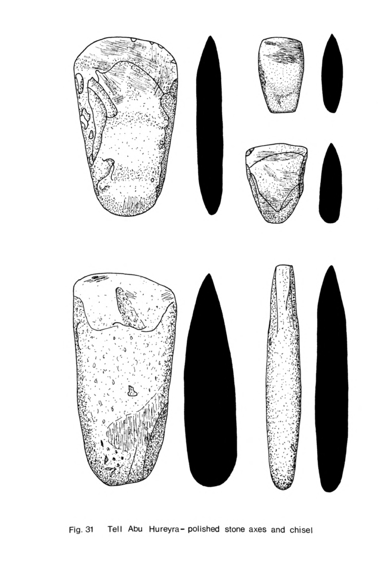
Fig.
31
Tell
Abu
Hureyra-polished
stone
axes
and
chisel
-
173
-
the
inhabitants
knew
how
to
fire
it
well
before
pottery
was
made
at
the
site.
Pottery
itself
was
found
in
the
ceramic
Neolithic
phase
and
then
only
in
small
quantities.
Most
of
it
was
from
simple
baggy
vessels
with
plain
or
collared
rims.
The fabric was coarse
and
crumbly
with
straw
temper
and
the
surface
of
the
vessels
was
burnished.
This
pottery
was
exceedingly
rough
though
it
did
resemble
that
very
broad
class
of dark
burnished
wares
found
on
other
Syrian
Neolithic
sites.
One
or
two
highly
burnished
black
or
brown
sherds
of
a
ware
found
at
Ras
Shamra
in
Phases
VB
and
VA
and
Tell
Rarnad
III
did
occur
at
Abu
Hureyra
as
well
as
others
decorated
with
red
paint.
A
few
strands
of
thread
found
in
a
clay
bead
indicate that
spinning
was
practised
at
the
site.
The
one
other
craft
for
which
we
have
good
evidence
is
basketry.
A
number
of impressions of
baskets
were
found
in
bitumen
which
had
been
used
as
a
lining.
There
were
also
traces
of
matting
in
the
soil
while
seeds
of
rushes
and
reeds
that
could
have
been
used
to
make
baskets
and
mats
were
recovered
in
flotation.
We
have already
noted
that
several
raw
materials
used
at
Abu
Hureyra
had
been
imported
from
a
considerable
distance.
Most
of
these
are
believed
to
have
come
from
the
Taurus
Mountains
and
Anatolia
300
km
to the
north.
The list
can
be
extended
to
include
a
pyritic
micaceous
stone
and
malachite
powder
which
was
apparently
used
as
a
cosmetic.
Several
objects
made of
this
particular
stone
were
found,
each
with
a
polished
U
groove
on
one
side
and
a
criss-cross
pattern
of
scratch
marks
on
the
back.
They
resemble
certain artifacts
found
at
Zawi
Chemi
Shanidar
in
a
slightly
earlier
context
interpreted
as
arrow
shaft
straighteners
(Solecki,
Solecki,
1970,
832,
839)
and
Mrs.
Helbaek
informs
me
that
a
few
similar
to
those
at
Abu
Hureyra
have
been
found
at
Beidha.
Several
other
raw materials
were
obtained
from
different
regions.
The
steatite
probably
came
from
the
Zagros
Mountains
while
a
bead
and
other
tiny
pieces
of
turquoise
may
have
originated
in
Sinai.
Cowrie
shells
were
found
in
every
phase
of the
Neolithic
settlement:
these
may
have
come
from
the
Mediterranean
or
the
warmer
waters
of the
Persian
Gulf
or
Red
Sea.
Although
these
links
suggest
contact
with
much of
the
Near
East
it
appears
that
more
of the
exotic
materials
were
imported
from
Anatolia
than
elsewhere.
This
may
simply
"be
"because
this
was
the
region
where
such
desirable
materials
were to
be
found
or
because
there
were
stronger
social
and
cultural
ties
between
the
inhabitants
of
Abu
Hureyra
and
the
peoples
to
the
north
than
their
contemporaries
elsewhere
and
that
these
links
were
strengthened
by
the
exchange
of such
materials.
These
raw
materials,
though
distinctive,
were
imported
in
small
quantities.
Other
more
common
materials,
basalt
and
certain
limestones
for
rubbers
and
stone
vessels,
gypsum
for
bowls
and
perhaps
bitumen
were
obtained
within
a
radius
of
60
km.
The
most
common
of
all
the
raw
materials
such
as
flint
were
to
be
found
in
the
vicinity
of
the
settlement
while
pebbles
of
greenstone,
granite
and
other
attractive
stones
could be
found
in
the
river
gravels.
No
lif
C
determinations
have
been
made
yet
on
the
charcoal
samples
from
Abu
Hureyra
and
until
these
are
available
one
can
discuss
the
chronology
of
the
site
only
in
very
general
terms.
Comparisons
with
Tell
Aswad
(Balikh)
and
Buqras
would
suggest
that
the
aceramic
phases
should
fall
within
the
7th
millennium
while
the
ceramic
Neolithic
levels
would
be
dated
about
6000
B.C.
or
a
century
or
two
later.
The
duration of
the
settlement
can
only
be
guessed
at
for
the
moment:
the
considerable
occupation
sequence
and
the
evidence
for
gradual
change
in
the
typology
of
the
flint
industry
and
other
artifacts
suggest
to
me
that
the
settlement
was
occupied
for
much
longer
than
Buqras,
for
example,
perhaps
from
the
beginning
of
the
7th
until
well
into
the
6th
millennium.
Certain
classes
of
remains
are
characteristic
of
the
aceramic
Neolithic
at
Abu
Hureyra.
Rectilinear mud-brick
buildings
composed
of
several
rooms
with
plaster
floors
are
one
example
and
the
burial
customs,
including
collective
secondary
burial associated
with
removal
of
skulls,
are
another.
A
third
is
the
flint
industry
which
used
large
blades struck
from
double-ended
and
keeled
cores.
These
were
retouched
to make
arrowheads,
end-scrapers,
burins
and
-
175
-
sickle
blades.
Such
remains
have
also
been
found
on
many
other
contemporary
settlements
in
the
Levant;
they
are
distinctive enough
to
"be
taken
as
charac-
teristic
features
of
this
new
stage
following
Neolithic
1
which
I
am
calling
Neolithic
2.
Some
other
artifacts
found
in
the
more
developed,
later
aceramic
phase
at
Abu
Hureyra
are
also
associated
with
Neolithic
2
remains
on
many
other
sites.
The
fine
stone
dishes
and bowls,
plaster
vessels
and
the
abundant
variety
of
bone
tools
may
be
included
here.
These
artifacts
were
almost
as
widespread
and
characteristic
of
Neolithic
2
as
the
three
major
classes
of
artifacts
I
mentioned
first.
Sites
in
the
neighbourhood
of
Tell
Abu
Hureyra
Three
small
Neolithic
surface
sites
have
been discovered
near
Tell
Abu
Hureyra.
One
is
on
the
right
bank
of
the
Wadi
Hibna
(site
III)
just
before
it
opens
out
into
the
Euphrates
flood-plain.
The
other
two
sites
(sites
I
and
II)
are
a
little
to the
east of
Abu
Hureyra
on
the
edge
of
the
same
terrace
above
the
flood-plain.
Flints
collected
from these
three
sites
can
be
paralleled
at
Abu
Hureyra
so it
looks
as
though
they
were
all
contemporary.
These
surface
sites
may
have
been
small
settlements
related
in
some
way
to
the
larger
centre.
One
other
prehistoric
tell
was
found
by
van
Loon
(^9^>7,
11)
3
km
to
the
east
of
Abu
Hureyra.
This
was
Tell
Kreyn
which,
like
Abu
Hureyra,
lay
on a
projection
of
the
first
terrace
into
the
flood-plain.
At
the
northern
end
there
was
a
small
mound
while
to
the
south
the
site
spread
out
over
the
surface
of
the
terrace.
The
mound
itself
yielded
a
surface
collection
of
Halaf
sherds
but
on
the
terrace
behind
there
were
abundant
flints
which
could
be
paralleled
at
Abu
Hureyra.
Tell
Kreyn,
while
still quite
small,
seems
to
have
been
a
more
substantial
settlement
than
sites
I,
II,
and
III.
It
was
certainly
occupied
at
the
same
time
as
Abu
Hureyra
then
perhaps
abandoned
and
resettled
in
Halaf
times.
-
176
-
Buqras
Buqras
lies
on
the
right
side
of
the
Euphrates
valley
10
km
below
the
confluence
with
the
Khabur.
It
is
situated
well
back
from
the
present
course
of
the
river
on
a
slight rise
above
the
flood-plain.
A
line
of
low
hills
lies
to
the
west
behind
the
site
and
beyond
them
the
Syrian
plateau.
These
hills
are
cut
by
several
dry
wadis
which
pass
near
the
site
on
their
way
to
join
the
Euphrates;
water
flows
in
them
today
only
after
severe
rain
storms.
The
area
is
semi-arid
now,
receiving
an
average
of
about
150
mm
of
rain
a
year.
The
site
is
a
little
over
3
ha
in
area
and
the
deposits
in
the
centre
of
the
mound
are
5
m
deep.
These
were
tested
in
1965
by
two
adjacent
k
m
square
soundings
excavated
to
the
natural
subsoil
(van
Liere,
de
Contenson,
1966,
181).
The
sequence
was
divided
into
three
phases
on
the
evidence
of
the
structures
and
artifacts
found.
Several
of
the
excavated
buildings
had
been
burned
or
otherwise
destroyed
but
there
was
nothing
to
suggest
that
these
were
more
than
localised
events.
The
settlement
appears
to
have
been
occupied
continuously
until
its
final
abandonment.
The
buildings
at
Buqras
were
rectilinear
in
plan
throughout
the
sequence
but
the
soundings
were
too
small
for
any
complete
plans
to
be
recovered.
All
the
buildings
were
oriented
north-west
south-east
as
at
Abu
Hureyra.
The
area
exposed
of
level
I
at
the
bottom
of
the
trenches
was
particularly
re
stricted
so
the
nature
of
the
structures
found
within
it
is
uncertain.
Parts
of
two
buildings
were
found
superimposed
in
this
level
(van
Liere,
de
Contenson,
1966,
182);
several
walls
of
each
were
exposed
which
were
believed
to
have
been
constructed
of
pise.
These
walls
were
quite
straight
and
the
photographs
suggest
that
they
were
well-made
(van
Liere,
de
Contenson,
1966,
fig.
10a)
;
it
may
be
that
they
were
in
fact
built
of
mud-bricks
,
as
were
the
later
struc
tures
at
Buqras
and
all
the
buildings
at
Abu
Hureyra
but
that
this
was
not
noticed
when
the
site
was
excavated.
The
lower
structure
had
a
hearth
in the
corner
of
a
room
and
areas
of
plaster
floors.
The
upper
one
consisted
of
at
least
one
room
entered
by
a
door
with
a
raised
sill;
traces
of
a
woven
mat
were
found
on
the
floor.

-
177
-
Level
II
consisted
of
a
complex
of
structures
which
was
remodelled
four
times
(van
Liere,
de
Contenson,
1966,
I83ff).
Each
was
composed
of
several
walls
and
"blocks
or
pillars
of
mud-brick
associated with
"bins
and
hearths.
The
"blocks
were
usually
attached
to
other
walls
and
so
may
have
strengthened
the
buildings
of
which
they
were
part.
A
number
of
floors
were
found
in
this
level, two of
them
plastered.
In
level
III
several more
mud-
brick
walls
were
found
and
a
hearth.
There
was
a
bin
in
the
angle
of
two
of
the
walls.
Although
very little
of
the
site
was
exposed
in
the
excavations
we
know
that
the
settlement
at
least
in
its
later
stages
was
closely
built
up
with mud-brick
buildings.
The
tops
of
the
walls
of
these
buildings
could
be
seen
all
over
the
surface
of
the
site
after
rain.
Most
of
the
chipped
stone
tools
were
made
of
a
fine-grained
dark
grey
or
brown
flint
found
in
the
wadi
gravels
or
on
the
surface
in
the
vicinity
o
of
the
site.
The
industry
was
based
upon
the
production
of
long
parallel-
sided
blades
struck
from
double-ended
and
keeled
or
occasionally
pyramidal
cores.
The
most
numerous
tool
types
were
burins
and
end-scrapers
on
blades.
Arrowheads,
though
quite
common,
were
much
less
abundant than
at
Abu
Hureyra.
There
were
sickle
blades
in
the
assemblage
but
they
were
rare
as
at
Abu
Hureyra.
The
other
flint
tool
types
were
flake
scrapers,
often
discoid,
and
borers.
Heavy
flake
tools
were
absent.
The
arrowheads
were
tanged
with
a
little
retouch under
the
tip
and
along
part
of
the
edge
(van
Liere,
de
Contenson,
1963,
fig.
XIII,
8-17)-
Most
tools
were
retouched
abruptly
but
pressure-flaking
was
used
on
some
of
the
arrowheads
throughout
the
sequence,
an
example
being
an
Amuq
point
from
layer
7-
The
same
tools
were
represented
throughout
the
sequence
although
the
proportions
varied
from
layer
to
layer.
The
industry
closely
resembles
that of
the
later
aceramic
and
ceramic
Neo-
lithic
at
Abu
Hureyra
both
in
technique
and
in
the
types
of
tool
which
were
made.
The
main
difference
is
in
the
proportions
of
the
tool
types,
burins
and end-scrapers
being
much
more
common
at
Buqras.
One
remarkable
feature
of
Buqras
was the
high
proportion
of
obsidian
in
-
170
-
the
chipped
stone
industry.
It
formed
32.3$
in
level
I,
25.7$
in
level
II
and
27.9$
in
level
III,
an
average of
about
29$
(Renfrew
et
al.,
1966,
59).
Six
pieces
from
level
I
have
been analysed
and
all
came
from eastern
Anatolia,
two from
the
he
source
which
could
be
either
Bingo'1
or
Nemrut
Dag,
and
four
from
1g
(Renfrew
et
al.,
1968, 325).
It
is
not
known
what
proportion
of
the
obsidian
if
any
came
from
central
Anatolia.
The
eastern
Anatolian
obsidian
sources
lie
about
k^O
km
north
of
Buqras.
The
route
is
direct
up
the
Khabur
across the
heights
behind
Mardin
and
on
to
the
upper
Tigris
basin.
Perhaps
this
ease
of communication
was
one
of
the
reasons
why
Buqras
received
so
much
obsidian.
Abu
Hureyra
is
only
UO
km
further
away
from
these
sources
as
the
crow
flies
but
received
much
less
obsidian,
partly
perhaps
because
the
easiest
route
to
the
sources
up
the
Euphrates
was
much
longer.
Much
of
the
obsidian
used
at
Buqras
consisted
of
small
retouched
blades
struck
from
conical
cores.
Cores
were
found
in
the
excavation
suggesting
that
the
material
was
being
worked
on the
site.
Several obsidian
tools
were
also
recovered,
among
them
burins,
borers,
disc
scrapers
and
even
one
microlithic
lunate
(van
Liere,
de
Contenson,
1966,
186).
The
remainder
of
the
artifact
industry
was
quite
rich,
particularly
in
bone
tools.
These
were
numerous
and
consisted
of
borers
of different
sizes,
hafts
for
other
tools,
needles
and
spatulae,
some
with
a
high
polish.
Saddle
querns
and
rubbers
of
basalt
and
limestone
were
quite
common;
there
were
also
a
few
basalt
pestles
and
a
mortar.
The
materials
for
these tools
could
have
been
obtained
in
the
locality.
A
distinctive
group
of
common
finds
were
the
fragments
of
polished
lime-
stone,
alabaster
and
gypsum
stone
bowls
and
dishes.
Some
were
hemispherical
in
shape, others
were
wide,
flat-bottomed
vessels;
one
even
had
a
carinated
profile
(van
Liere,
de
Contenson,
1963,
fig.
XEII,
2).
All
the
materials
for
these
would
have
been
available
in
the
neighbourhood.
Cylindrical
or
discoid
beads
and
other
objects
of
adornment
were another
- 179
-
numerous
class
of
finds.
The
"beads
were
made
of
"bone,
shell,
greenstones
from
the
Euphrates
gravels,
carnelian
imported
perhaps
from
some
distance
away
and
dentalium
from
the
Mediterranean.
An
alabaster
"bracelet
fragment
and
pendant
were
also
found
on
the
surface
(van
Liere,
de
Contenson,
1966,
186).
Much
less
common
but
quite
distinctive
were
several
stone
stamp
seals
with
incised
chevron
and
rectangular
patterns
(van
Liere,
de
Contenson,
1963,
fig.
XIII,
6;
1966,
fig.
8
9
19,
28).
One
was
made of
alabaster
and
another
of
jadeite
from
Anatolia.
Two
axes,
one
polished
all
over
and
the
other,
of
greenstone,
pecked
and
polished, were
found
but
they
were
apparently
rare
tools
at
Buqras,
at
least
in
the
area
excavated.
Baked
clay
figurines
were
also
uncommon,
as
at
Abu
Hureyra, only
a
few
anthropomorphic
and
animal
examples
being
found.
One
piece
of
a
white plaster
vessel
was
picked
up
from
the
surface of
the
site
and
another
was
found
in
the
excavation
(van
Liere,
de
Contenson,
1966,
185).
The
fragment
from
the
surface
came
from
a
vessel
which
had
been
made
on
a
mat
for
it
retained
the
pattern
of
the
criss-cross
weave
on
its
base.
Pottery
was
used
for the
first
time
at
Buqras
in
level
III.
This
seems
to
have
been
quite
rare
at
the
site
as
only
1U
sherds
were
found.
The
sherds
belonged
to
a
small
upright
bowl,
cylindrical
vessels
with
flat
bases
and
other
rounded
bowls.
The
fabrics
were
varied,
several
thin
sherds
being
tempered
with
straw
and
others
with
quartz
sand
filler;
there
were
also
coarse
straw-tempered
sherds.
Several
sherds
had
a
bright red
painted
surface
and
were
highly
burnished
while
a
number
of
the
plain
sherds
were
also
burnished,
though
not
so
thoroughly.
One
sherd
had
a
triangle
painted
on
it.
The
same
great
variety
of
artifacts
was
found
both
at
Buqras
and
in
the
aceramic
and
ceramic
Neolithic
levels
at
Abu
Hureyra.
Occupation
at
both
sites
concluded
with
a
short
phase during
which
pottery
came
into
use.
The
pottery
was
quite
varied
in
form
and
decoration
at
both
sites.
The
vessels
seem
to
-
180
-
have
been
made
in
much
the
same
way:
they
had
a
soft
fabric
tempered
with
straw
which
was
burnished
or
in a
few
instances
painted.
Buqras
enjoyed
even
closer
contacts
with
Anatolia
than
did
Abu
Hureyra
on
the
evidence
of
the
obsidian
and
other
raw
materials
were
also
received
from
that
direction.
The
artifacts
at
Buqras
were
all
quite
similar
throughout
the
sequence
which
would
indicate
that
the
site
was
not
inhabited
for
long.
The
14
C
determinations
bear
this
out
as
they
are
clustered
together.
One
from
the
bottom
of
level
I
is
6190
±
60
B.C.
GrN-l*8l8
and
another
from
the
top
of
the
level
is
6290
±
100
B.C.
GrN-^52.
The
date
for
level
II
is
6010
±
55
B.C.
GrN-^819
and
for
level
III
5990
±
60 B.C.
GrN-^820
(Radiocarbon
9,
1967,
128).
While
not
quite
all
in
order,
they
form
a
tight
acceptable
series
from
which
one
might estimate
that
the
site
was
founded
about
6300 B.C.
and
abandoned
about
5900
B.C.
or
a
little
after.
Tell
Aswad
(Ealikh)
Tell
Aswad
lies
on
a
tributary
of
the
Balikh
about
22
km
south
of
Tell
Abyad
in
the
Syrian
Jezireh.
The site
is
roughly
oval
in
shape
with
two
high
points
at
either
end.
It
was
discovered
by
Mallowan
who
excavated
on
the
higher
summit
in
1938.
He
found
traces
of
Halaf
occupation
but
surmised
that
much
of
the
mound
consisted
of
Neolithic
remains
(Mallowan,
19^-6,
126).
The
site
was
reinvestigated
by
Cauvin
in
1970
who
excavated
a
step
trench
from
top
to
bottom
of
the
higher
summit
on
its
northern
side.
The
lower
summit
has
never
been
examined
and
its
relationship
to
the
rest
of
the
site
is
unknown.
Cauvin
divided
his
sequence
into
eight
levels
numbered
from
top
to
bottom.
Levels
I
to
VI
contained
remains
of
mud-brick
buildings,
a
lime
plaster
floor,
flints
and
other
artifacts
but
were
devoid
of
pottery
(Cauvin,
Cauvin,
1972,
88).
Levels
VII
and
VIII
at
the
bottom
yielded
only
a
few
bricks
and
fragments
of
plaster
but
abundant
artifacts
including
many
sherds
of
pottery.
About
half
the
sherds
had
a
red
or
brown
surface
and
were
burnished;
these
had
either
grit
or
straw
filler
(Cauvin,
Cauvin,
1972,
86ff).
The
remaining
sherds
were
from
much
coarser
straw-tempered
vessels
with
little
surface
treatment.
A
-
181
-
few
sherds
only
had
red
painted
decoration.
Most of the
pots
were
hole-mouth
vessels
and
several
had
strap
handles,
knots
or
lugs
for
carrying.
The
chipped
stone
industry
was
of
much
the
same
character
throughout
the
sequence.
The
tools
were
made
on
blades
and
flakes
struck
from
pe"b"ble
cores.
The
principal
types
were
tanged
arrowheads
with
a
little
abrupt
retouch,
burins,
end-scrapers
on
blades,
disc
scrapers
and sickle
blades
with
some
borers.
The
sickle
blades
were
short
truncated
blades
for
the
most
part
which
are
believed
to
have
been hafted
so
that
they
formed
a
jagged
cutting
edge
(Cauvin,
1973,
fig.
3).
They
were
quite
numerous
in
every
level.
Obsidian
was
present
throughout.
Among
the
other
artifacts
were
numerous
fragments
of
small
polished
limestone
and
alabaster
bowls.
The
remaining
finds
included
a
few
baked
clay
anthropomorphic
and
animal
figurines,
some
bone
points,
basalt
grinders,
three
butterfly
beads
and
several
other
items
of
adornment.
Three
carbon
1U
determinations
have
been
made
on
samples
obtained
in
the
recent
excavations. They
are:
for
level
VIII
6500
±
120
B.C.
Mc-86U,
level
VI
10,550
±
160
B.C.
Mc-607 and
level
III
6700
±
120
B.C.
Mc-865
(J.
Cauvin,
197^b,
203).
Cauvin
has
concluded
on
the
evidence
presented
above
that
Tell
Aswad
was
first
occupied
in
the
middle
of
the 7th
millennium
by
a
group
making
pottery.
They
were
the
first
people
in
Syria
to
use
pottery
regularly
as
all
other
finds
of
early
pottery
are
dated
several
centuries
later.
Although
people
with
the
same
material
culture
continued
to
occupy
the
site
for
a
considerable
time
pottery
was
not
used
in
the
later
stages of
the
settlement
(J.
Cauvin,
197^-b,
203).
This
explanation,
if
correct,
would
fit
the
observed
facts
but
it
seems
so
improbable
that
another hypothesis
may
be
preferred.
Let
us
first
consider
the
cultural
parallels
for
the
Tell
Aswad
material.
The
flint industry,
stone
bowls
and
other distinctive
artifacts
such
as
the
butter-
fly
beads
closely
resemble
those
from
the
later
aceramic and
ceramic
Neolithic
at
Abu
Hureyra
and
Buqras.
The
only
significant
difference
is
that
the
sickle

-
182
-
blades
at
Tell
Aswad
are
of
a
different
type
and
more
common
than
at
the
two
other
sites.
Even
the
Tell
Aswad
pottery,
though
much
more abundant
than
that
from
the top
levels
at
Abu
Hureyra
and
Buqras,
encompasses
the
same
range
of
wares
and
decoration.
One
may
conclude
that
the
Tell
Aswad
material
is
sufficiently
like that
on
the
Euphrates
sites
to be
included
in
Neolithic
2
of
the
Levant.
It
is
thus
all
the
more
strange
that
a
sequence
repeated
at
Abu
Hureyra
and Buqras
of
an
aceramic and
then
ceramic
Neolithic
with
otherwise
much
the
same
material
inventory
should
be
reversed
at
Tell
Aswad.
The
stratigraphy
at
Tell
Aswad
was
determined
from
a
step
trench
rather
than
a
deep
sounding
carried
to
bedrock
at
the
centre
of
the
site.
It
is
perfectly
possible
that
when
the
settlement
was
founded
pottery
was
not
made
but sub-
sequently
the
focus
of
the
settlement
shifted
north
at
about
the
time
pottery
began
to
be
used.
The
true
stratigraphic relationship
between
an
earlier
settlement
with
a
considerable
depth
of
deposit
and
a
later
extension
at
a
lower
elevation
might
be
missed
in
a
step
trench
excavated
across
such
occupation
deposits.
The
Halaf
remains
on
top
of
the
old
heart
of
the
site
could
be
unrelated
to
the
earlier
occupation.
At
this
point
we
may
look
once
more
at
the
^C
dates.
On Cauvin's
reading
of
the
stratigraphy
the
dates
for
level
VIII
and
level
III
are
inverted,
the
earlier
level
being
dated
later.
If
on
the
other
hand
my
suggestion
were
correct
the
dates
would
be
in
the
right
order,
so
lending
weight
to
the
argument.
The
problem
cannot
be
resolved
satisfactorily
without
further
excavations
but
it
would
seem
more
likely
that
Tell
Aswad
was
first
occupied
by
a
group
which
did not
use
pottery
and
that
they
adopted
the
craft
later
rather
than
the
reverse
explanation
put
forward
by
Cauvin.
One
difficulty
remains
with
the
Tell
Aswad
sequence
and
that
concerns
the
14
C
determinations.
Two
of
the
dates
fall
within
the
first
half
of
the
7th
millennium
so one
might
assume
that
the
site
was
occupied
then.
The
typology
of
the
artifacts
links
the
site
closely
with
Buqras
which
is
itself
dated
about
6000
B.C.
It
is
difficult
to
believe
that
Tell
Aswad
was
really
occupied

-
183
-
that
early
as
it
would
be
typologically
more
advanced
"by
several
centuries
than
not
only
Buqras
"but
also
a
number
of
other
dated
sites
in
the
Levant.
As
one
of
the
determinations
is
altogether
much
too
early
(Mc-607)
it
may
"be
that
the
other
dates
are
also
incorrect.
Cauvin
found
one
other
site
in
the
Balikh
valley
with
remains
similar
to
those
from
Tell
Aswad.
The site
is
Tell
Khirbet
el
Bassal
which
lies
on
the
Karamuk,
a
tributary which
flows
parallel
with
the
Balikh
on
the
west.
It
has
not
"been
excavated
"but
Halaf
sherds
were
found
near
the
summit
and
flint
and
obsidian
artifacts
lower
down
together
with
fragments
of
stone
bowls
comparable
with
those
at
Buqras
(Cauvin,
1970,
287).
Tell
Fakhariyah
Neolithic
artifacts
were
found
in
unusual
circumstances
at
Tell
Fakhariyah,
a
large
Iron
Age
and
Classical
site
which
lies
just
to
the
south
of
Ras
el
Ain
beside
one
of
the
sources
of
the
Khabur.
The
artifacts
were
all
flint
and
obsidian
tools
though
there
is
a
possibility
that
some
ground
and
polished
stone
axes
might
also
be of
the
same
age
(Braidwood,
1958,
55).
About
1,000
flint
and
200
obsidian
pieces
were
saved
from
soundings
IV,
VI
and
IX.
They
seem
to
have
been
embodied
in
the
mud-bricks
of
the
buildings
on
the
site.
It
is
thought
that
the
mud
for
the
bricks
must
have
been
obtained
from
a
prehistoric
deposit
either
on
the
tell
itself
or
in
the
vicinity.
The
flint
and
obsidian
tools
belonged
to
a
single
industry
with
a
variety
of
tool
types
(Braidwood,
1958,
53ff).
The
flint
tools
were
mostly
made
on
long
regular
blades,
some
parallel sided
and
some
pointed.
No
cores
were
saved but
the
scars
on
the
tools
indicate
that
the
blades
were
struck
from
double-ended
cores.
The
arrowheads
were
as
much
as
8
or
9
cm
long.
They
were
tanged
with
some
abrupt
retouch
around
the
tang
and
under
the
tip.
Some
sickle
blades
had
a
little
irregular
retouch along
the
cutting
edge
but
others
had
none
at
all
nor
were they
retouched
along
the
back
or
at
the
ends.
End-scrapers
on
blades
were
numerous
and
burins
were
also
quite
common.
The
latter
consisted
-
18U
-
of
single-blow
and
angle
burins
for
the
most
part
and
quite
a
number
were
made
on
broken
tanged
arrowheads.
Borers
were
also
made
on
blades,
the
long
points
being
shaped
with
abrupt
retouch.
The
only
flake
tools
were
a
few
disc
scrapers made
on
quite
thick
flakes.
Almost
all
of these tools
were
retouched
abruptly,
pressure-flaking
being
very
rare.
The
obsidian
tools
were mostly
blades
and
blade
segments
,
a
number
of
which
were
retouched
along
one
edge.
Some
blades
were
thicker with
abrupt
retouch
on
both
sides
to
make
borers
or
reamers.
This
assemblage
is
similar
to
the
flint
industry
in
the
aceramic
Neolithic
levels
at
Abu
Hureyra.
The
range
of
tool
types,
the
way
they
are
made
and
even
certain
details
such
as
the
reuse
of
broken
arrowheads
as
burins
are
all
the
same.
The
principal
difference
would
appear
to
be
that
obsidian
was
used
more
commonly
in
the
Tell
Fakhariyah
assemblage,
doubtless
because
the
site
was
nearer
the
Vannic
obsidian
sources.
The
parallels
with
the
Abu
Hureyra
flint
industry
are
so
close
that
one
may
reasonably
conclude
that
the
site
from
which
the
Tell
Fakhariyah
material
came
was
inhabited
about
the
same
time,
that
is
in
Neolithic
2
during
the
7th
millennium.
The
rarity
of
pressure-flaking
in
the
retouch
reinforces
the
suggestion
that
the
assemblage
is
earlier
than
the
ceramic
Neolithic
at
Abu
Hureyra
and
Buqras
III.
Tell
Fakhariyah
is
the
furthest
to
the
north-east
of
all
the
known
sites
with
a
Neolithic
2
assemblage:
indeed
it
lies
well
beyond
the
Levant
proper.
The
significance
of
Tell
Fakhariyah
and
Tell
Aswad
is
that
they show
that
there
were
sites
on
both
the
Balikh
and
Khabur
inhabited
during
the
7th
millennium
by
groups
whose
cultural
equipment
was
the
same
as
other
Neolithic
2
communities
living
along
the
Euphrates.
Jebel
Abdul
Aziz
Eight
prehistoric
sites
were
discovered
along
the
north
scarp
of
the
Jebel
Abdul
Aziz
by
a
Japanese
team
in
1967.
All
were
described
as
"Post-
Palaeolithic"
(Suzuki,
Kobori,
1970,
3^ff)
but
only
two
are
definitely
Neolithic.
These
are
an
open
site
Sheikh
Abdul
Aziz
(site
26)
and
a
shelter
-
185
-
Khazne
Cave
I
(site
28).
The
flint
tools
collected
from
site
26
and
the
terrace
in
front
of
site
28
included
end-scrapers,
flake
scrapers
and retouched
blades
(Suzuki,
Kobori,
1970,
fig. UT)
.
None
of
the
tools
is
sufficiently
diagnostic
for
one
to
be
certain
in
which
stage
of
the
Neolithic
the
sites
were
occupied
but
from
the
appearance
of
the
blades
which
broadly
resemble
material
from
Abu
Hureyra
it
is
more
likely
to
have
been
during
Neolithic
2
than
later.
Both
sites are
small
and
their
nature
is
uncertain.
El
Kum
The
site
of
El
Kum
is
near
a
well
and
modern
village
of
the
same
name
which
lie
on
the
track
from
Sukhne
to
Risafe
in
the
pass
between
the
Jebels
Abu
Rujmein
and
Bishri.
It
was
first
visited
by
Laurisson
Ward
in
1938
who
made
a
collection
of
flints
and
plaster
vessel
fragments
which
is
now
in
the
Peabody
Museum
at
Harvard.
He
also
discovered
another
surface
Neolithic
site,
almost
certainly
occupied
in
Neolithic
2,
10
km
south
of
Risafe.
El
Kum
was
rediscovered
by
Dr.
and
Mrs.
Buccellati
who
surveyed
the
area
in
1966
(1967»
305)
and
found
many
other
prehistoric
sites
in
the
pass.
The
site
is
a
large
mound
about
25
m
high.
A
brief
excavation
was
carried
out
there
in
1967
in
which
it
was
discovered
that
the
bottom
10.35
m
of
deposdt
consisted
of
aceramic
Neolithic
with
a
further
^.85
m
of
ceramic
Neolithic
above
(Dornemann,
1969
5
68);
remains
of
a
later
period
of
occupation
were
found
in
the
top
layers
of
the
mound.
The
structures
in
the
aceramic
levels
consisted
of
clay
walls
and
mud
plaster
floors
with
fragments
of
red
burnished
plaster
that
could
have
been
either
from
floors
or
walls.
Two
superimposed
rectilinear
clay-walled
buildings
were
found
in
the
ceramic
levels;
each
had
several
rooms
with
white
plastered
floors
and
walls.
An
unusual
feature
of
the
upper
building
was
that
it
contained
a
staircase
connecting
rooms
on
different
levels.
n
The
flint
industry
was
composed
of
blade
and
flake
tools.
The
blades
were
large,
parallel-sided
ones
struck
off
double-ended
hog-backed
and
keeled
cores.
There
were
some
tanged
arrowheads
with
a
little,
abrupt
retouch
or
-
186
-
pressure-flaking
on
a
few
pieces.
Burins
on
blades
were much
more
common,
consisting
for
the
most
part of
angle
burins.
Backed
blades
with
abrupt
retouch
were
also
quite
numerous.
Sickle
blades
and
end-scrapers
on
blades
were
present
in
small
quantities.
There
were
also
many
flake
scrapers
made
on
quite
thin
flakes
which
were
then
retouched
around
the
edge.
The
industry
seems
to have
changed
very
little
throughout
the
long
period
in
which
the
site
appears
to
have
been
occupied.
Polished
fragments
of
limestone
and
alabaster
bowls
were
quite
abundant
in
the
Neolithic
levels.
The
vessels
were
hemispherical
in
shape,
ranging
in
size
from
small
cups to
larger
dessert
bowls.
Bone
points
and
spatulae
were
also
found
throughout. Then there
were
a
variety
of
other artifacts
such
as
a
polished
stone chisel,
a
stone
weight
and
other
holed
stones,
a
baked
clay
stamp
seal
and
beads.
The
two
other
major
classes
of
finds
were
fragments
of
plaster
vessels
and
potsherds.
Both appear
only
to
have
been
found
in
the
ceramic
Neolithic
levels
although
it
is
possible
that
plaster
vessels
were
used
earlier
and
not
recovered
in
the
small area
excavated.
Many
pieces of
plaster
vessels
were
collected,
more
than
at
any
other
excavated
Levantine
site.
Most
of
these
vessels
were
large,
open,
quite
deep
circular
jars
with
flat
bases.
A
few
were
more
squat
and
hemispherical,
one
or
two
were
rectangular
and
there
was
a
large
flat
platter.
The
walls
were
usually
thick
and
made
of
several
layers
of
plaster.
Often
a
thin
layer
of
plaster
had
been
carefully
applied
to
the
surface
perhaps
to
make
the
vessels
impervious
to
moisture.
Many
of
the
vessels
retained
impressions
of
matting
on
their
bases
and
coiled
baskets
on
their
sides.
From
this
one
can see
that
these
vessels
were
often
made
inside
a
large
basket
of
coiled
straw
or
rushes
which
gave
support
until
the
plaster
had
set.
This
is
also
excellent
evidence
for
use
of
basketry
and
matting
at
the
site.
Pottery
was
abundant
in
the
ceramic
Neolithic
layers.
The
ware
had
a
buff
finish
with
much
straw
temper
although
a
few
vessels
had
a
flint
chip
and
grit
filler.
Many
of
the
sherds
were
undecorated
but
some
had
been
painted
-
187
-
red
all
over.
A
proportion
of
both
the
plain
and
red
painted
vessels
had
then
"been
burnished.
El
Kum
is
a
large
site
with
a
very
substantial
depth
of
deposit
built
up
from
the
collapse
of
the
buildings
of
what
appears
to
have
been
a
concen-
trated
settlement.
Not
enough
is
known
about
the
site
to
say
much
about
how
its
inhabitants
lived
but
it
is
clear
that
their
buildings
and artifacts
were
broadly
similar
to
those
on
the
sites
we have
already
discussed.
The
closest
parellels
for
the
flint
industry
are
to
be
found
at
Abu
Hureyra
and
Buqras
although
the
proportion
of
tools
found
differed
from
both
these
sites
and
flake
tools
seem
to
have
been
more
common
at
El
Kum
than
elsewhere.
The
use of
stone
bowls
and
white
plaster
vessels also
links
El
Kum
with
the
Euphrates
sites.
Aceramic
El
Kum
should
thus
be
contemporary
with
the
later
aceramic
Neolithic
at
Abu
Hureyra
and
Buqras
I
and
II.
The
ceramic
Neolithic
layers
are
probably
of
the same
date
as
Buqras
III
and
the
ceramic
Neolithic
at
Abu
Hureyra
but
occupation
at
El
Kum
seems
to
have
continued
later
than
at
the
other
two
sites.
The
aceramic
Neolithic
at
El
Kum
falls
within
Neolithic
2
in
the
Levant
but
with
the
introduction
of
pottery occupation
at
the
site
entered
a
new
phase.
Palmyra
region
Many
prehistoric
sites
have
been discovered
in
recent
years
around
Palmyra
by
the
Japanese
survey
team.
k6
of
these
were
found
in
1967
and
all
were
ascribed
to
the
"Post-Palaeolithic"
although
it
was
recognised
that
some
also
had
earlier
remains
(Suzuki,
Kobori,
1970,
36).
The
published
material
from
23
of
these
sites
includes
flints
which
are
certainly
Neolithic
and
it
may be
that
some
of
the
other
sites
also
have
indications
of
Neolithic
occupation.
21
of
the
sites
were
rock
shelters
with
a
terrace
in
front
and two
were
open
stations.
Some
were
found
on
the
southern
slopes
of
Jebel
ed-Duara
and
along
the
Wadi
el
Ahmar
(sites
33,
3^.,
J35,
36, 38,
k±
9
U2,
^3,
U8,
5J_,
52)
to
the
norths-east
of
Palmyra.
Four were
discovered
immediately
to
the
north
and
-
188
-
north-west
of the
oasis
(sites
53, 5^,
56,
60)
and
the
remainder
on
the
slopes
of
the
Jebel
el
Abyad
further
to
the
north-west
(sites
63, 6k,
65.,
66,
69,
71
,
lit,
II).
The
chipped
stone
assemblages
from
all
these
sites
belong
to
the
same
industry.
There
were
double-ended
and
keeled
cores
(Suzuki,
Kobori,
fig.
52,
^;
Suzuki,
Akazawa,
1971,
figs.
2,
3)
with
characteristic
crested
blades
and
flakes (Suzuki,
Kobori,
1970,
fig.
h9
,
12,
1*0
;
Suzuki,
Akazawa,
1971,
fig.
11),
The
ventral
surfaces
of
the
blades and
blade
tools
had
scars
from
other
blades struck
off
both
ends
of
the
parent
cores,
another
typical
feature.
Among
the
tools
there
were
tanged
arrowheads,
burins
on
blades
and
scrapers
on
flakes
and
blades
(Suzuki,
Kobori,
1970,
figs.
hQ,
6-9;
1*9,
1-11;
50,
1-12)
but
of
these only
the
arrowheads
and
the
blades
on
which
some
of
the
tools
were
made
are
really
diagnostic.
These
artifacts
are
all
characteristic
of
Neolithic
2
assemblages
else-
where
in
Syria.
The
shape
of
the
arrowheads
and
the
squared-off
tangs
of
some
of
them
in
particular
are
paralleled
closely
in
the
aceramic
levels
at
Abu
Hureyra
which
indicates
that
this
groups
of
sites,
like
El
Kum,
may
be
grouped
with
those
on
the
Euphrates
on
typology
and technology.
Since these
sites
were
discovered
a
large
manufacturing
station
has
been
found
by
the
Japanese
on
the
salt
flats
in
front
of
Duara
cave
which
they
are
excavating.
Strewn
on
the
surface
were
large
quantities
of
double-ended
cores,
waste
and
blades
of
a
Neolithic
2
industry.
I
have
found
other
flints
of
the
same
industry
in
the
classical
ruins
at
Palmyra,
particularly
on
the
northern
side
beyond
the
city
wall
of
Justinian,
enough to
indicate
that
there
were
other
Neolithic
2
stations
in
this
area.
The
evidence
which
has
been
accumulated
is
sufficient
to
show
that
the
Palmyra
area
was
occupied
by
a
number
of groups
during
Neolithic
2.
The sites
are
not
very
large
so
none of the
groups
can
have
been
anything
like
as
numerous
as
the
community
which
inhabited
El
Kum.
-
189
-
The
38
sites
discussed
so
far
range
from
small
surface
stations
to
large
tells.
They
are
all
situated
well
inland
on
the
plateau
of
central
and
northern
Syria.
Within
this
region
they
occupy
diverse
zones:
the
Palmyra
hills,
the
Euphrates
valley,
the
Balikh
and
headwaters
of
the
Kha"bur,
yet
their
material
remains
are
sufficiently
similar
for
one
to
conclude
that
they
were
occupied
in
Neolithic
2
by
people
who
shared
a
common
culture.
If
one
compares
the
remains
from
these
sites
with
contemporary
settlements
else-
where
in the
Levant
one
finds,
however,
that
they
have
some
distinctive
features
which
mark
them
out
as
a
regional group
of
sites
within
Neolithic
2.
It
is
"best
to
identify
these
features
on
excavated
settlements
with
the
longest
well-stratified
sequence
of
occupation,
Abu
Hureyra
and
Buqras,
and
then
look
for
them
on
the
other
sites.
This
regional
variation
can
be
seen
most
clearly
in
the
flint
industry
at
Abu
Hureyra
and
Buqras.
The
techniques
of
blade
production
here
were
exactly
the
same
at
other contemporary
sites
throughout
the
Levant but
the
tools
made
from
these
blades were
distinctive.
The
principal
types
were
arrowheads,
burins and
end-scrapers;
sickle
blades,
though
more
numerous
at
Buqras
than
Abu
Hureyra,
were
still
relatively
rare
compared
with
other
Levantine
Neolithic
2
sites.
These
tools
were
usually
shaped
with
a
minimum
of
abrupt
retouch.
Squamous
pressure-flaking
was
never
a
common
technique
in
the
Neolithic
2
levels
at
either
site.
On
sites
in
the
southern
Levant
and
in
the
Damascus
basin
it
was
used
much
more
frequently
than
on
the
Euphrates
sites.
The
arrowheads
at
Abu
Hureyra
and
Buqras
were
all
tanged
as
they
were
often
elsewhere
but
certain
types
were
typical
of
the
Euphrates
sites.
Most
of
the
arrowheads
had
a
tang
which
was
clearly
separated
from
the
rest of
the
blade
by
a
pair
of
shoulders;
the
tangs
were
also
often stubby
and
squared
off,
another
characteristic trait
rarely
found
elsewhere.
None
of
the
arrow-
heads
on
these
sites
had
notches. Some
flake
scrapers
were
found
but
other-
wise
almost no
other
flake
tools
nor
core
tools
either
although
these
were
found
in
some
numbers
on
Levantine
sites
nearer
the
coast.
-
190
-
When
the
stratified
assemblages
from
Abu
Hureyra
and
Buqras
are
compared
with
material
from
the
other
36
sites
it
can
"be
seen
that
all
share
these
specific
characteristics
of
their
flint
industries.
This
is
as
true
of
the
surface
material
from
the
sites
around
Palmyra
and
Tell
Fakhariyah
as
of
the
other
excavated
sites,
Tell
Aswad
(Balikh)
and
El
Kum.
These
sites
thus
form
a
regional
cultural
group
within
Neolithic
2
in
the
Levant.
All
the
sites
except
those
around
Palmyra
and
El
Kum
are
vithin
the
Middle
Euphrates
drainage
system
which
gives
them
a
certain
geographical
unity;
they
may
thus
all
be
called
the
Middle
Euphrates
group
of
sites
to
distinguish
them
from
the
other
regional
groupings to
which
I
shall
now
turn.
West
Syria
A
second
regional
group
of
sites
is
to
be found
in
West
Syria
(Fig.
32).
This
comprises
sites
in
the
Damascus
basin,
Lebanon
and
on
the
coast
of
Syria.
There
are
three
in
the Damascus
basin.
One
of
these,
Tell
Aswad,
was
occupied
continuously
from
the
latter
part
of
Neolithic
1
until
well
into
Neolithic
2,
as
we have
seen.
This
is
the
only
site
discovered
in
the
region
so
far
that
has
a
continuous
sequence
from
one
stage
to the
next
and,
since
it
provides
this
link,
I
shall
consider
it
first.
Tell
Aswad
The
transition
from
phase
I
to
phase
II
at
Tell
Aswad
took
place
about
6900
B.C.
or a
little
later.
Aswad
II
is
dated
by
several
determinations,
three
of
them
from
a
series
in
the
west
trench:
6770
±
75
B.C.
GrN-6677,
6700
±
55
B.C.
GrN-6676,
6610
±
110
B.C.
GIF-2373,
and
one
from
just
below
the
surface
of
the
east
trench,
6590
±
110
B.C.
GIF-2369
(de
Contenson,
I973a,
25U).
This
is
a
consistent
series
of
dates
which
places
the
second
phase
of
occupation
at
Tell
Aswad
firmly
in
the
first
half
of
the
7th
millennium
B.C.
The
site
appears
to
have
been
deserted
about
6500
B.C.
The
flint
industry of
Aswad
II
was
based
on
the
production
of
blades
as
in
Aswad
I.
Most
of
these
were
struck
off
prismatic
and
pyramidal
cores
so
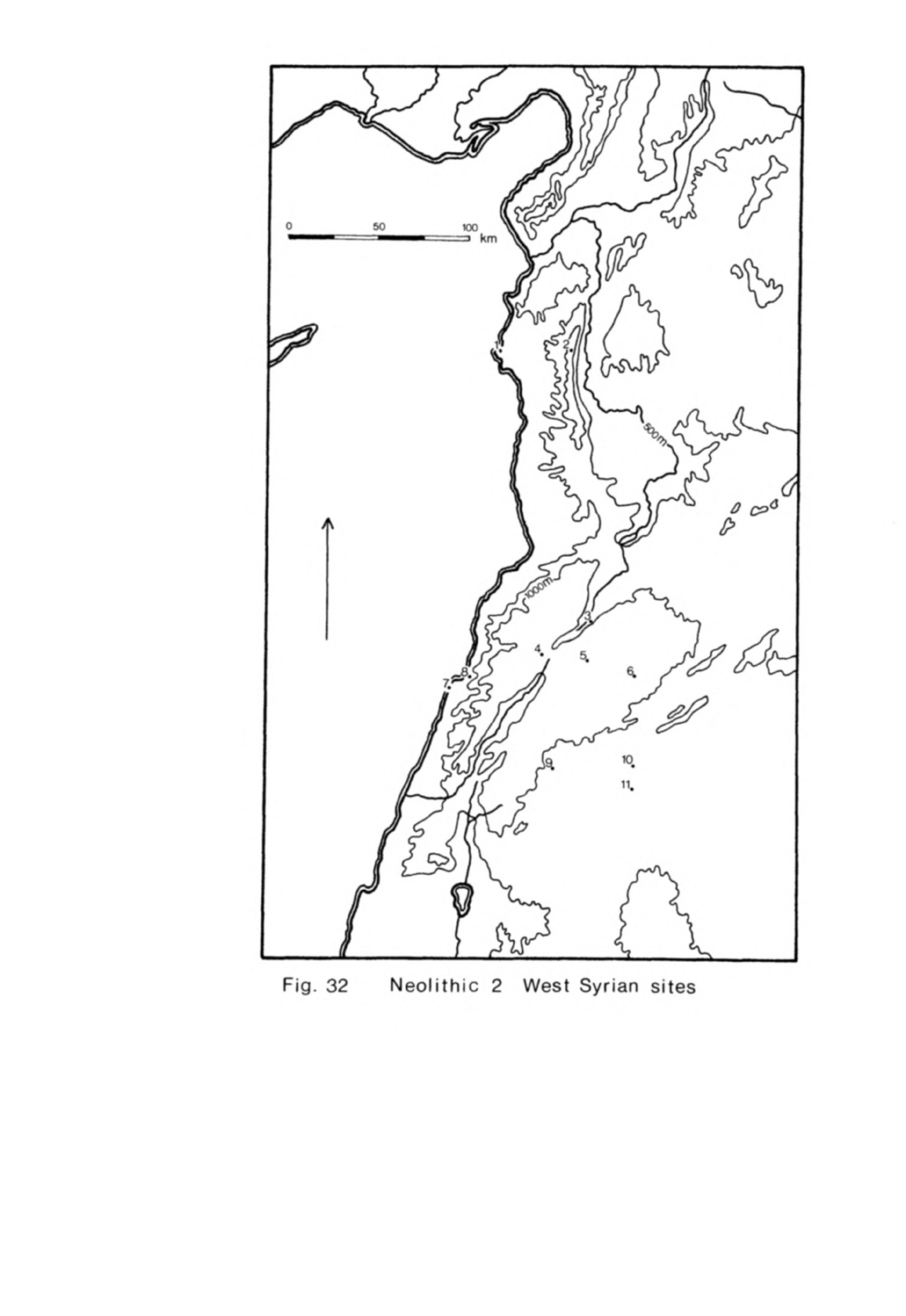
Fig.
32
Neolithic
2
West
Syrian
sites

FIGURE
32
Neolithic
2
¥est
Syrian
sites
1
Ras
Shamra
2
Slenfe
3
Tell
Labweh
4
Saaideh
5
Nacharini
6
Mugharet
el
Abde
7
Tell
aux
Scies
8
Dik
el
Mehdi
II
9
Tell
Ramad
10
Ghoraife
11
Tell
Aswad
-
191
-
they
tended
to
have
converging
sides;
relatively
few
came
from
bipolar
cores
in
contrast
with
the
Euphrates
sites.
The
latter
are,
of
course,
for
the
most
part
later
in
date.
A
wide
range
of
tools
was
made
on
these
blades,
retouched
blades
or
knives
being
particularly
common.
Sickle
blades
were
also
numerous
(de
Contenson,
1972,
77);
these
had
finely
serrated
or
nibbled
cutting
edges
though
some
were
denticulated.
A
few
had
retouch
along
the
back
and
there
were
also
some
segmented
sickle
blades.
The
third
most
common
class
of
tools
in
Aswad
II
was the
arrowheads.
Most
of
them
were
tanged
in
this
phase,
the
tang
being
defined
by
a
curved
narrowing
of
the
blade
rather
than
a
sharp
shoulder.
Some
of these
were
retouched
abruptly
but
most
had
pressure-flaked
tangs,
in
contrast
with
the
Euphrates
sites
where
most
tangs
were
abruptly
retouched.
Retouch
was
confined
to
the
tang
and
tip
on
most
of
the
Aswad
II
arrowheads.
Notched
arrowheads
with
a
short
tang which
had
been
so
common
in
Aswad
I
were
still
present
but
in
much
diminished
quantity.
The
remaining
tools
consisted
of
notched
and
denticulated
blades
and
flakes,
burins
on
blades, borers
of
various
sizes
and
end-scrapers
on
blades.
Flake
tools
were
relatively
scarce
but
among these
a
series
of
quite
thick
disc
scrapers
seem
to
have
been
characteristic.
Some
chisels
were
flaked
in
flint
and
a
few
had
polished
edges.
A
number
of
flaked
and
polished
axes
were
also
made
from
a
variety
of
stones.
About
1%
of
the
chipped
stone
artifacts
at
Tell
Aswad
were
of
obsidian.
5U
pieces
of
obsidian,
20%
of the
total,
have
been
analysed
from
phases
I
and
II
in
the
west trench
as
part of
the
Bradford
programme.
The
analyses
suggest
that
the
proportions
of
obsidian from
different
sources
were
about
the
same
in
both
phases.
Three
sources
were
being
exploited,
(Jiftlik
(U6.3%),
1g
(11
and
Nemrut
Dag
(k2..6%).
From
this
one
may conclude
that
central
and
eastern
Anatolian
obsidian
was
being
used
in
about equal amounts
even
though
the
Vannic
sources
are
about
200
km
further
away
by land
than
Q^iftlik.
One cannot
be
sure
that the
obsidian
analyses
from
the
west trench
are
representative
of
the
whole
-
192
-
site
so
it
vill
be
necessary
to
analyse
obsidian
from
the
east
trench
to
see
if
these
results
are
corroborated.
The
other
artifacts
from
Aswad
II
were
varied
but
not
very
numerous.
The
bone
tools
consisted
of
borers,
needles, spatulae
and
a
few
hafts.
There
were
also
some
fragments
of
polished
stone
bowls.
Articles
of
adornment
were,
however,
quite
common.
They
consisted
of
beads
and
pendants
made
in a
wide
range
of
materials:
limestone,
carnelian, steatite,
shell,
bone,
turquoise
and
even
obsidian.
The
exotic
stones
in
this
list,
like
those
at
Abu
Hureyra,
would
have
been
imported
from
Anatolia,
the
Zagros
and
Sinai.
Baked
clay
objects
were
very
common
throughout
the
sequence.
A
number
of
these
were
simply
lumps
or
balls
of
clay
and
others
were
shaped
like
pawns.
Many
animal
figurines
were
made,
often
with
a
marked
dorsal
ridge
and all
were
modelled
with
assurance.
Some
were
recognisable
as
cattle,
pigs
and
small
horned
ruminants
(de
Contenson,
1972,
78).
The
remainder
were
anthropomorphic
figurines,
mostly
of
seated
women. The
figurines
were
made
to
appear
plump
but
there
was
much
variation
in
shape.
Some
were
quite
schematic
with
stmup
bodies
and
rod
heads
and
hardly
any
delineation
of
the
limbs.
Tell
Ramad
Tell
Ramad
was
discovered
by two
French
customs
officials
before
the
Second
World
War.
One
of
them,
M.
Compant,
and
an
army
officer,
Lieutenant
Potut,
collected
material
from
the
site on
several
occasions
(Potut,
1937»
130).
The
site
was
visited
in
1939
by
Laurisson
Ward
who
collected
more
material from
the
surface
which
is
now
in
the
Peabody
Museum.
Tell
Ramad
remained
known
to
at
least
one
scholar
(Nasrallah,
1965,
51)
"but
had
otherwise
been
generally
forgotten
until
rediscovered by
van
Liere
and
de
Contenson
(1963,
179).
The
site
is
situated
20
km
south-west
of
Damascus
at
the
foot
of
Mt.
Hermon.
It
lies on
a
high
undulating
plateau
at
an
elevation
of
830
m
at
the
edge of
the
Wadi
Sherkass
which
flows
into
the Damascus
basin.
The
mound
is
approximately
rectangular
in
shape
and
about
2
ha
in
area
(de
Contenson,

-
193
-
van
Liere,
196U,
pi.
X).
There
are
two
high
points
on
the
western
side
with
a
wide
almost
level
"bench
to
the
east.
The
northern
side
slopes
steeply
down
into
the
wadi.
Eight
seasons
of
excavation
have
taken
place
at
Tell
Ramad
since
1963.
The
full
sequence
of
occupation
was
determined
from
three
trenches
excavated
in the
first
season;
since
then
these
trenches have
been
extended
to
obtain
as
broad
an
exposure
as
possible
of
the
layout
of
the
settlement.
The
occupa-
tion
layers
which
are
about
5
m
thick
have
been
divided
into
three phases;
Levels
I
and
II
making
up
the
bulk
of
the
site
are
aceramic
Neolithic
(de
Contenson,
1971,
279ff)
and
Level
III
is
ceramic
Neolithic.
Another
later
phase
of
occupation
has
been
postulated
on
the
evidence
of
sherds
found
on
the
surface
but
any
occupation
layers
of
this
phase
have
eroded
away.
Level
I
was
about
2
m
thick
on
the
east
side
but
only
0.7
m
deep
on
the
west of
the
site
(de
Contenson,
van
Liere,
1966,
171)«
It
would
appear
from
this
that
when
the
site
was
first
settled
the
eastern
sector
was
occupied
more
intensively
but
that
almost
the
whole
area
of
the site
was
inhabited.
The
most
conspicuous
features
of
this
phase
were
a
number
of
oval
pits
from
3
to
U
m
in
diameter
lined
with
clay
(de
Contenson,
1967,
19).
These
pits
contained
hearths
ovens
and
other
depressions
which
suggest
that
they
may
have
served
as
working
hollows
or
even
dwellings.
In
the
same
deposit there
were
also
rectangular
bins
made
of
clay
which
may
have
been
for
storage
(de
Contenson,
1969a,
17),
a
number
of
lime
plastered
surfaces
and
other
floors.
The
deposits
and
structures
of
Level
II
were
quite
different
from
those
in
Level
I
yet
there
is
nothing
to
suggest
that
there
was
a
break
in
occupation
between
the
two
phases.
Level
II
was
from
2.35
to
h.3
m
thick
(de
Contenson,
van
Liere,
1966,
169)
and
extended
over
the
whole
site.
This
deposit
which
is
exposed
over much
of
the
surface
of the
mound,
was
very
ashy,
a
feature
from
which
its
Arabic
name was
derived.
The
structures
in
this
level
had
a
single
rectangular
room
built
of
mud-bricks
on
a
stone
foundation
(de
Contenson,
1969a,
28).
The
corners
were
rounded
which
avoided
the
structural
problem
of
joining
two
brick
walls
at
a
right
angle.
The
"buildings
varied
in
size,
one
being
T
by
5.5
m
and
another
9
by
k.5
m,
but
most
had
plaster
floors.
These
structures
which
are
quite
uniform,
have
been
found
across
the
site
and
it
is
probable
that
they
were
dwellings.
Outside
these
buildings
were
several
pits
which
contained
carbonised
seeds
(de
Contenson,
1967
S
19)
indica-
ting
that
food
was
probably
stored
in
them.
Hearths,
ovens
and
prepared
working
surfaces
could
all
be
traced
outside
the
buildings
(de
Contenson,
1970,
77)
which
were
separated by narrow
lanes
and
courts.
Burial
customs
were
the
same
in
Levels
I
and
II.
Human
remains
were
buried
in
shallow
graves
inside
buildings
sometimes
beneath
the
floors
and
also
outside.
A
few
crouched
burials
were
found
intact
(de
Contenson, van
Liere,
1966,
170;
de
Contenson,
1967,
20)
but
most
corpses
appear
to
have
been
deposited
incomplete
in
communal
graves.
The
latter
frequently
lacked
skulls
and
other
parts
of
the
skeleton
indicating
that
secondary
burial
had
taken
place.
Very
few
grave goods
were
deposited
with
these
skeletons.
Several
groups
of
skulls
were
found
which
had
been
buried
separately from
the
corpses
to
which
they
belonged
(de
Contenson,
van
Liere,
196U,
111;
de
Contenson,
1967»
20;
1969a.
27).
Single
skulls
and
other
human
remains
occurred
throughout
the
deposits.
The
lower
part of
the
face
and
chin
of
some
of
these
skulls
had
been
covered
with plaster
which
had
the
effect of
partly
restoring
the
appearance
of
the
face.
The
plaster
and
the
remainder
of
the
skull
was
frequently
decorated
with
red
ochre.
Both male and
female
skulls
were
treated
in
this
way
(Ferembach,
1969,
67ff)
Associated
with
one
of
these
groups
of
skulls
were
the
remains
of
two
clay
figures.
Both were
seated
and
the
better
preserved
one
which
was
about
25
cm
high
had
at
least
one
arm
akimbo
(de
Contenson,
1967
5
21).
It
is
thought
that
these
figures,
the
more
complete
of
which
was
headless,
may
have
served
as
stands
on
which
the
plastered
skulls
were
mounted.
The
flint
industry
of
Levels
I
and
II
at
Tell
Ramad
was
composed
principally
of
blade
tools.
The
blades
were
struck
from pyramidal
and
- 195 -
double-ended
cores
y
a
few
of
which
were
keeled.
Some
of the
tools
in
"both
phases
were
made
on
bladelets
(de
Contenson,
van
Liere,
1966,
170;
de
Contenson,
1970,
33), a
feature
quite
absent
on
the
Euphrates
sites.
The
principal
classes
of tools
were
sickle
"blades
and
arrowheads.
The
sickle
blades
were
of
two
types,
blades
with
sickle
gloss
but
little
or
no
retouch
and segmented
blades
(de
Contenson,
van Liere,
196U,
11U).
The
segmented
sickle
blades
had
finely
denticulated
edges
and
were
frequently
retouched
around
the sides
to
reduce
their
thickness.
In
Level
II
some of
these
had
coarse
denticulation.
There
were
also
two
groups
of arrowheads,
one
notched
and
one
with
long
tangs.
The
notched
arrowheads
had
pairs
of
notches
along
the
blade
and
a
pair
at
the
base
to
define
a
short
tang.
This
type
though
found
in
both
levels was
not
so
common
in
Level
II
(de
Contenson,
1971
5
283).
The
other
arrowheads
had
a
long
tang
sometimes
defined
by
shoulders.
Many
of
these
arrowheads
and
some
of
the
sickle
blades
were
retouched
with
squamous
pressure-
flaking
.
The
other
blade
tools
consisted
of
types
found
on
many
other
Neolithic
2
sites,
retouched
blades,
borers and
burins.
End-scrapers
on
blades
were
uncommon
but
flake
scrapers,
principally
discoids
and
end-scrapers,
were
numerous.
Another
important
and
characteristic
group
of
tools
was
the flaked
axes.
Most
were
small
and
quite
thin
with
a
polished
cutting
edge
but
a
few
had
a
tranchet
edge.
Their
shapes
were very
varied;
some
were
ovoid,
others
trapezoidal
or
semicircular with
a
straight
edge.
A
few
axes
and
adzes
were
much
larger
than
these
small
woodworking
tools.
All
such
axes
both
large
and
small
were
almost
entirely
absent
on
the
Euphrates.
Obsidian
formed
approximately
\%
of
the
chipped
stone
industry
at
Tell
Ramad.
Most
of
it
was
in
the
form
of
small
blade
segments
although
a
few
retouched
tools
and
worked-out
cores
were
found,
sufficient
to
indicate
that
some
of
it
was
finished
on
the
site.
Five
pieces
have
been
analysed
by
-
196
-
optical
spectrography
three
of
which
came
from
Ciftlik
and
two
from
group
^c
in
eastern
Anatolia
(Renfrew
et
al.,
1966,
h6).
A
sixth
piece
analysed
"by
neutron
activation
also
came
from
group
he
(Wright,
Gordus,
1969
9
83)
Renfrew
look
at
kO
pieces
visually
and
concluded from
this
that
only
10%
of
the
obsidian
in
fact
came
from
the
Lake
Van
area,
presumably
because
this
propor-
tion
was
green
in
colour.
Recent
work
has
thrown
doubt
upon
this
observation
because
some
grey
obsidian
has
now
been
shown
to
come
from
the
Van
region
as
well.
At
Tell
Aswad
and
Ghoraife,
another
site
in
the
Damascus
basin,
where
larger
samples
have
been
analysed
a
much
higher
proportion
of
the
obsidian
came
from
Lake
Van
and
it
would
be
surprising
if
the
pattern
at
Ramad
was
very
different
because
the
sites
are
so
close
together,
their
sequences
over-
lap
and
their
material
culture
has
much
in
common.
The
remaining
artifacts
from
Levels
I
and
II
were
varied
in
type
as
we
have
noted
on
other
Neolithic
2
sites.
White
ware
was
a
characteristic
feature
of
Level
II
but
was
not
found
in
Level
I.
The
forms
were
either
cylindrical
vessels
with
a
flat
bottom
or bowls
with
a
ring
base
(de
Contenson,
van
Liere,
1966,
169).
Some
of
the
vessels
were
burnished
and
painted
with
a
red
line
around
the
rim
and
body.
Pieces of
white
ware
and
the
plaster
floors
have
been analysed
to
deter-
mine
their
composition
and how
they were
made.
The
analyses
have
shown
con-
clusively
that
both
materials
were
calcium
carbonate
(Balfet
et
al.,
1969
9
191;
Gourdin,
Kingery,
19T5»
1^-7)
"but
there
is
some
doubt
about
how
they
were
manufactured.
Balfet
and
her
collaborators
think
that
limestone
was
baked
on
the
site
in
pits
to
obtain
the
lime.
They
have
analysed
the
soil
of
Ramad
II
and
found
it
to
be
full
of
ashes,
crushed
limestone
and
traces
of
grass.
They
believe
the grass
played
a
part
in
the
actual
fashioning
of
the
lime
plaster.
One
huge
pit was
found
on
the
site
which
could
well
have
been
used
for
this
purpose
(de
Contenson,
1969b,
32).
Gourdin
and
Kingery
point
out,
however,
that
limestone
has
to
be
baked
at
a
very
high
temperature
to
obtain
lime
(1975s
1^9).
As
very
large
quantities
of
lime
were
used
for
floors
on

-
197
-
these
Neolithic
sites
they
believe
that
this
could
only have
"been
regularly
made
in
kilns.
No
kilns
have
been
found
on
these
sites
"but
as
Gourdin
and
Kingery
remind
us
limeburning
is
an
unpleasant
business
and
such
kilns
might
well
have
been
sited
beyond
the
confines
of
the
settlement.
The
question
is
unresolved
but
it does
seem
that
some
lime
could
be
obtained
from
pit
fires
and
it
also
seems
probable
that
the
ashy
soil
at
Ramad
is
partly
the
result
of
this.
Kilns
may
have
been
used
at
other
sites
at
this
time
although
there
is
no
good
evidence
for
them
until
much
later.
However
the
lime
was
obtained,
it
was
then
used
as
a
plaster
to
build
up the
white
ware
vessels.
Balfet
believes
that
a
pozzolanic
reaction took
place
in
which
the
plaster
set
like
cement.
Gourdin
and
Kingery
cast
some
doubt
on
this
but
do
not
offer
a
clear
explanation
of
how
they
think
the
vessels
were
made.
The
heavy
stone
tools
were
of
the same
type
in
both
levels
(de
Contenson,
van
Liere,
196U,
11U,
11?)-
Most
of
them
were
made
of
basalt which
was
easily
obtainable
on
the
Golan plateau.
They
included
pestles
and
stone
balls
together
with
open
ended
stepped
querns
and
rubbers.
Small
polished
bowls
in
alabaster
and
limestone
were
also
made
but
only
in
Level
I
apparently
(de
Contenson,
van
Liere,
196^,
115).
Bone
tools
were
common
finds
in
both
levels and
particularly
abundant
in
Level
II.
The
usual
types
in
Level
I
were
borers and spatulae
while
in
Level
II
there
were
also
needles,
beads
and
hafts
(de
Contenson,
van
Liere,
196*1,
11U,
117).
Clay
figurines
were
another
very
common
find
particularly
in
Level
II.
Most
were
sun
dried
but
a
few
appear
to
have
been
baked.
They
usually
portrayed
animals
and humans
although
there
were plenty
of
pawn-like
figurines
and
other
abstract
shapes.
Cattle,
caprines,
equids
and
pigs
could
be
recognised
among
the
many
animal
figurines
(de
Contenson,
1971,
281).
The
other
artifacts
were
also
quite
varied.
Among
them
were
stone
spindle
whorls
which
supplement
our
knowledge
of
the
range
of
crafts
practised
by
the
inhabitants.
The
objects
of
adornment
included
cylindrical beads
of
-
198
-
bone
and
different
stones
and
other
beads
made
of
shell,
obsidian,
carnelian
and
steatite
(de
Contenson,
1970,
33);
the
three
latter
materials
were
probably
imported
from
Anatolia
or
the
Zagros.
There
was
also
at
least
one
butterfly
bead
of
the same
shape
as
those
at
Abu
Hureyra
(de
Contenson,
van
Liere,
1966,
fig.
2a,
U).
Pendants
were
less
common
but
they
included
examples
in
shell
and
also one
carved
on
bone
which
was
an
accomplished rendering
of
the
head
of
a
ruminant
(de
Contenson,
1970,
pi.
16).
An
unusual
find
from
Level
I
was
a
copper
pendant.
The
pendant
had
been
bored
through
so
that
it
could
be
threaded
on
a
string.
Traces
of the
vege-
table
fibre
yarn
by
which
it
had
been suspended
could
be
seen
in
the
hole
(France-Lanord,
de
Contenson,
1973,
111).
The
pendant
was
made of
native
copper
which
it
is
believed
may
have
come
from
southern
Turkey.
It
might
equally
have
been
derived
from
Edom
or
Sinai
where
there
were
also
copper
deposits.
The
chronology
of
the
sequence
at
Tell
Ramad
has
been
quite
well
estab-
lished
by
a
series
of six
^C
determinations.
The
dates
for
Level
I
are
6250
± 80
B.C.
GrN-1^28
and
6lUO
±
50
B.C.
GrN-U821
(Radiocarbon
9,
1967,
129),
which
suggest
that
the
site
may
have
been
first
occupied
in
the
second
half
of
the
7th
millennium,
perhaps
about
6300
B.C.
There
are
three
determinations
for
Level
II:
5970
±
50
B.C.
GrN-^U27,
5950
±
50
B.C.
GrN-U822
and
6260
±
50
B.C.
GrN-iiU26.
The
first
two
fit
the
sequence
very
well
but
the
last
one
which
was
obtained
from
a
sample
taken
near
the
surface
appears
to
be
aberrant
or
may
have
been
determined
on
old
wood
charcoal. If one
considers
only
the
first
two determinations
it
would
appear
that
Level
II
began
about
6000
B.C.
but
we
do
not
know
for
certain
when
the
change
from
Level
II
to
Level
III
took
place.
Ghoraife
Ghoraife, like
Tell
Aswad,
is
situated
on
the
floor
of
the
Damascus
basin
about
22
km
due
east of
Damascus.
It
is
now
8
km
west
of
the
present
Ataibe

-
199
-
lake
but
would
have
been much
nearer
the
shore
at
the
time
it
was
occupied.
A
small
sounding
2
m
square
excavated
here
in
197^-
showed
that
there
was
7.5
m
of
deposit
on
the
site.
There
was
no
indication
within
the
sounding
of
mud-brick
or
stone
buildings
but
there
were
pieces
of
clay
incorporating
impressions
of
reeds
(de
Contenson,
1976,
80)
which
were
presumably
the remains
of
mud
and
reed
huts
of
the
kind
thought
to
have
been
used
at
Tell
Aswad. The
deposit
in
the
sounding
consisted
of
layers
of
mud, ashes
and
burned
earth.
These
layers
may
have
been
the
washed
out
remains
of
such
structures
and
the
occupation
floors
associated
with
them.
There
were
also
a
number
of
large
pits
in
the
lower
layers.
The
deposit
has
been
divided
into
two
phases
based
more
upon alterations
in
the
typology
of
the
artifacts
than
any
marked
change
in
the
stratigraphy
for the
deposits
seem
to
have
been
of
much
the
same
kind
from
bottom
to
top
and
there
was
no
discernible
break
in
the
occupation
sequence.
Phase
I
at
the
bottom
was
characterised
by
a
chipped
stone
industry
which
used
large
blades
struck
from
double-ended
cores
some of
which
were
keeled.
h1%
of
the
retouched
tools
were
finely-denticulated
sickle
blades,
25%
of
other
retouched
blades
and
only
\\.^%
arrowheads.
These
had
a
long
tang
and
were
retouched
abruptly.
The
other
tools
included
a
few
burins
and
disc
scrapers
on
flakes.
A
little
obsidian
was
also
used
but
otherwise
there
were
few
ground
stone
tools
or
bone
artifacts.
The
rest
of
the
deposit
has
been
designated
Phase
II
(de
Contenson,
1976,
81).
The
flint
industry
was
much
less
abundant
and
appears
to
have
changed
quite
markedly,
although
this
may
partly
be
the
result of
condensing
complex
data
for
a
preliminary
note.
Most
of
the
tools
were
still
made
on
blades
but
these
were
struck
from
prismatic
and
pyramidal
cores
derived
from
tabular
flint.
Arrowheads now formed
31.8%
of
the
retouched
tools,
retouched
blades
30%
as
before
but
sickle
blades
only
15%.
Burins
and
discoids
were
still
used
in
small
quantities.
Some
of
the
tools
were
now retouched
by
squamous
pressure-flaking.
A
few
flaked
axes
with
polished
edges
were
made
for
the
-
200
-
first
time
and
there
were
more
"basalt
and
limestone
tools.
Bone
tools of
several
types
were
numerous
now.
About
2%
of
the
total
chipped
stone
at
Ghoraife
was
of
obsidian
and
2h
pieces
of
this,
20%
of
the
total,
have
been
analysed
in
the
Bradford
programme.
Obsidian
was
being
used
from
the
same
three
sources
as
at
Tell
Aswad,
that
is
Ciftlik,
1g
and
Nemrut
Dag,
though
1g
obsidian
was
found
only
in
Phase
II;
as
the
quantities
analysed
were
quite
small
this
may
not
be
significant.
Taking
Phases
I
and
II
together
obsidian
from
these three
sources
was
present
in
roughly
equal
amounts,
Ciftlik
33%,
1g
29%
and
Nemrut
Dag
3Q%
which
on
present
evidence
would
indicate
a
strong
preference
for
obsidian from
eastern
Anatolia.
The
sample
analysed
from
Ghoraife
is
still
too
small
for
one
to
be
sure
if
the
proportions
of
obsidian
from
the
different
sources
have
been
correctly
determined.
Even
so
the
results
from
Ghoraife
and
Tell
Aswad
together
indicate
that
Vannic
obsidian
was
used
at
least
as
much
'as
obsidian
from
Ciftlik,
a
conclusion
that
greatly weakens
the
earlier
hypothesis
that
most
obsidian
used
in
the
Levant
at
this
period
was
obtained
from
the
Aksaray
region
(Renfrew
et
al.,
1968,
326).
Five
llf
C
determinations
have
been
obtained
for
these
levels
and,
like
those
for
Tell
Aswad
and
Tell
Ramad,
they
form
a
consistent
series.
Those
for
Phase
I
are
6760
±
190
B.C.
GIF-3376,
6530
±
190
B.C.
GIF-3375
and
6^50
± 190
B.C.
GIF-337^,
all
in
stratigraphic
order.
The
two
dates
from
Phase
II
are
6200
±
190
B.C.
GIF-3372
and
^990
±
190
B.C.
GIF-3371,
the
second
of
which
appears
to
be
too
late
for
its
archaeological
context.
There
was
much
surface
disturbance
at
the
site
and
it
is
believed
that
this
may
have
contaminated
the
sample.
From
these
dates
one
would
estimate
that
Ghoraife
was
settled
about
6800
or 6900
B.C.
and
that
the
transition
from
Phase
I
to
Phase
II
took
place
about
6300
B.C.
The
site
was
deserted
perhaps
about
6000
B.C.
although
this
figure
is
uncertain.
From
the
chronology
above
it
is
clear
that
Phase
I
at
Ghoraife
was
contemporary
with
Tell
Aswad
II
and
Phase
II
with
Tell
Ramad
I.
The
site thus
overlapped
chronologically
the
other
two
-
201
-
Damascus
basin
sites
but,
surprisingly
for
a
site
so
close
to
the
others,
there
appear
to have
been
marked
differences
between
the
flint
assemblages
of
Ghoraife
and
the
other
sites,
at
least
on
the
information
available
so
far.
The
Ghoraife industry
throughout
was
based
on
blade
production
as
at
the
other
sites
but
in
Phase
I
the
cores
were
double-ended
whereas
in
Aswad
II
they were
usually
prismatic
or
pyramidal.
The
main tool
types
were
used
in
similar
proportions,
sickle
blades
being
much
more
common
than
arrowheads
for
example,
which
implies
that
much
the
same
activities
were
being
practised
at
these
two
sites
which
occupied
the
same
environment.
Even
so
there
were
considerable
differences
between
the
arrowheads
because
squamous
pressure-
flaking
was
used
commonly
at
Tell
Aswad
but
not
at
Ghoraife.
Such
differences
in
technique
between
two
neighbouring
contemporary
sites
are
unusual
since
elsewhere
in
the
Levant
at
this
time
basic
techniques
of
flint
production were
the
same
on sites
over
a
wide
area
as
we have
seen
in
the
Euphrates
region.
Ghoraife
II
and
Ramad
I
had
more
in
common
in
their
flint
industries
although
these
two
sites
were
in
different
environments,
one
on
a
high
plateau
and
the
other
in a
lake
basin.
The
core
techniques
were
quite
similar
although
double-ended
cores
were
more
common
at
Ramad.
Pressure-flaking
seems
to
have
been
used
to
about
the
same
extent
at
both
sites.
Arrowheads
were
more
frequent
at
Ghoraife
than
at
Ramad
but
as
the
setting
of
the
two
sites
was
different
this
probably
reflects
differences
in
subsistence.
Ramad
had
some
segmented
sickle
blades
by
this
time,
a
type
apparently
absent
at
Ghoraife.
Flaked
and
polished
axes
were used
at
both
sites.
Interestingly
enough,
the
bone
industry
was
also
quite
rich
at
both
of
these
sites
although
far
fewer
bone
tools
were
found
in
Ghoraife
I.
What
this
all
suggests
is
that
although
there
are
general
resemblances
between
the
artifacts
from
these three
sites
there
are
quite
specific
differ-
ences
in the
details
of
their
material
remains.
These
must
partly
reflect
differences
in
subsistence
activities
but
the
variation
in
basic
techniques
of
flint
production may
'have
more
to
do
with
the
relations
between
the
inhabitants
of
these
sites
in
the
phases
when
they
were
occupied
at
the
-
202
-
same
time.
These three
sites
share
certain
general
characteristics
with
the
Euphrates
valley
sites.
The
buildings
at
Ramad
are
rectilinear
even if
"built
differently.
White
ware
is
found
on
sites
in
both
regions
towards
the
end
of
this
stage.
The
burial
rites
are
generally
quite
similar
although
at
Ramad
the
plastered
skulls
were
treated
differently
from
the
usual
practice
on
the
Euphrates
sites.
Much
the
same
range
of
exotic
materials
was
being
received
at
all
these
sites
and
in
the
three
sites
where
large
samples
of
obsidian
have
been
analysed
obsidian
was
being
obtained
from
the
same
sources,
from
Lake
Van
as
much
as
or
more than
Ciftlik.
The
general
features
of
the
flint
industries,
the use
of
large
blades
and
the
widespread
introduction
of
double-ended
cores,
are
also
common
to
both
areas.
This
list
of
common
features
together
with
the
chronological
evidence
is
enough
to
establish
that
the
sites
in
the
Damascus
basin,
Aswad
II,
Tell
Ramad
I
and
II
and
Ghoraife,
not
only
belong
to
Neolithic
2
of
the
Levant
but
share
many
fundamental
aspects
of
their
culture
with
the
Euphrates
sites.
That
having
been
established,
it
is
also
apparent
that
the
Damascus
basin
sites
form
a
distinct
group
and,
whatever
the
differences
between
them,
have
certain
things
in
common
which
distinguish
them
from
the
Euphrates
sites.
As
is
usually
the
case
this
can
best be
seen
in
the
flint
assemblages.
To
begin
with
there
is
greater
variation
in core
technique
in
the
Damascus
basin
towards
the
end
of
Neolithic
2,
that
is
at
Ghoraife
II
and
Ramad
I.
Pressure-flaking
is
also
used
much
more commonly
there
than
on
the
Euphrates,
particularly
for
retouching
arrowheads.
Sickle
blades
are
more
abundant
on
all
the
Damascus
basin
sites
and
the
segmented
sickle
blades
at
Tell
Ramad
are
quite
different
from
the few
sickle
blades
known
in
the
Euphrates
area.
Flaked
and
polished
axes
are
a
type
absent
on
the
Euphrates
but
abundant
in
the
Damascus
basin
in
late
Neolithic
2,
an
important
indicator
of
a
variation
in
response
to
a
different
environment.
The
buildings
of
Ramad
II,
despite
their
use
of
mud-
brick
and
plaster
floors,
are
of
a
different
plan
from
those
at
Abu
Hureyra
and
elsewhere
on
the
Euphrates.
Then
again
one
might
note
the
very
large
-
203
-
number
of
human,
animal
and
abstract
clay
figurines
found
at
both
Tell
Aswad
and
Tell
Ramad
which
are
a
very
rare
find
on
the
Euphrates
sites.
I
will
now
consider
the
other
Neolithic
2
sites
in
Syria and
Lebanon
to
see
if
they
belong
within
the
West
Syrian
group.
Tell
Labweh
The
modern
village
of
Labweh
is
in
the
Beka'a
26
km
north-east
of
Baalbek.
There
are
two
Neolithic
sites
here,
one
just
to
the
north
of
the
village
which
has
not
been
excavated
and
another
to
the
south
which
is
the
site
with
which
we
are
concerned.
Tell
Labweh
stands
on
a
low
hill
at
the
side
of
the
valley
where
the
land
rises
up
towards
the
Anti-Lebanon
Mountains.
It
overlooks
springs
which
are
one
of
the
sources
of
the
Orontes.
The
site
is
spread
over
a
wide
area but
the
deposits
are
only
about
h
m
deep.
The
surface
has
been
much
disturbed
by
agricultural
terraces
and
a
new
road
has
been
dug
through
the
mound
cutting
it
in
two.
Kirkbride
has
made
two
soundings
in
the
site
to
obtain
the
sequence
of
occupation.
Trench
A
was
not excavated
to
bedrock
but
the
lowest
levels
reached
were
devoid
of
structures.
Above
them
were
two
superimposed
rectangular
buildings
with
several
rooms
(Kirkbride,
1969»
^6).
The
lower
courses
of
the
walls
were
built
of
stone
but
it
is
thought
that
the
upper
parts
would
have
been
made
of
mud-brick.
The
floors
of
these
buildings
were
surfaced
with
white
burnished
plaster
and
red
burnished
plaster
floors
could
be
seen
in
the
section
beside
the
new
road.
Several
secondary
burials
were
found
in
these
structures.
The
first
metre
of
deposit
above
the
subsoil
in
Trench
B
contained
no
structures
(Kirkbride,
1969,
^8).
Higher
up
there
were
traces
of
floors
which
may
have
belonged
to
buildings
but
the
rest
of
the
deposit
was
cut
by
a
series
of
large
pits
which
were
filled
with
stones
and
fine
black
soil.
The
flint
industry
at
Labweh
was
fairly
homogeneous
but
there
were
indications
that
some
of
the
tool
forms
changed
during
the
life
of
the
site.
-
20^
-
Flint
blades
were
struck
off
double-ended
and
pyramidal
cores
with
crested
blades
as
a
by-product.
The
sickle
blades
in
the
lower
levels
had
finely
denticulated
edge
retouch
with
backing
and
were
often
retouched
transversely
at
the
ends.
In
the
upper
levels
most
of
the
sickle
blades
were
segmented
with
coarse
denticulation
(Kirkbride,
1969
9
50).
Many
of
the
arrowheads
had
pressure-flaked
tangs
which
were
formed
by
a
slight
narrowing
of
the
blade
but
a
fragment
of
at
least
one
notched
arrowhead
was
found
on
the
site.
These
were
the
main
diagnostic
tools
but
many
other
types
were
found
such
as
angle
and
dihedral
burins,
stubby
awls
and
a
variety
of
flake
scrapers.
Obsidian
was
used
throughout
the
sequence.
Flaked
and
polished
stone
axes
were
numerous
and
there
were
two
small
ones
made
from
imported
stones
which
had
been
polished
all
over.
Bone
tools
were
quite
abundant
and
included
borers,
pins
and
spatulae.
All
levels
except
those
at
the
bottom
of
Trench
B
contained much
white
plaster
ware.
The
most
common
shape
of
vessel
was
a
flared
bowl
with
a
high
flared
ring
base.
Two
types
of
heavier
vessel
were
also
found,
both
of
them
deep
cylindrical
jars
with
flat
bases
quite
like
those
from
Tell
Ramad.
One
had
a
plain
rim
and
the
other
one
an
everted
lip
which
included
a
ledge
inside
for
a
lid.
A
little
pottery
was
found
in
the
upper
building
in
Trench
A
and
in
the
pits
near
the
surface
in
Trench
B.
Pottery
was
absent
in
the
lower
levels
at
the
site
although
in
view
of
the
small
area
dug
Kirkbride
does
not
rule
out
the
possibility
that
these
apparently
aceramic
levels
might
yield
pottery
in
more
extensive
excavations
(1969>
^8).
Three
charcoal
samples
from
the
bottom
of
Trench
B
have
been
14
C
dated,
the
average
of
the
result
being
a
figure
of
5950
B.C.
K-1^28,
1^29,
1^30
(Kirkbride,
1969,
50).
The
buildings
at
Labweh,
many
of
the
artifacts
and
the
form
of
the
burials
bear
a
general
resemblance
to
remains
on
some of
the
Neolithic
2
sites
I
have
considered
so
far.
The
parallels
with
Level
II
at
Tell
Ramad
are
particularly
close
as
Kirkbride
has
pointed
out
(1969,
51).
The
buildings were
constructed
-
205
-
in
the
same
way
with
stone
footings
and
plaster
floors
although
those
at
Ramad
had
only
one
room
and
at
Labweh
several.
The
flint
industry
is
similar
in
both
core
technique
and
the
range
of
tools
made.
There
is
a
particularly
close
resemblance
between
the
sickle
blades and
arrowheads
at
Labweh
and
those
at
Ramad
II.
An
abundance
of
white
plaster
vessels
is
another
trait
common
to
both.
Furthermore,
the
dates
are
in
close
agreement.
These
parallels
are
sufficiently
close
to
indicate
that
the
lower
levels
at
Labweh
were
occupied
in
Neolithic
2,
albeit
at
the
very
end
of
this
stage.
The
cores,
after
all,
already
show
that
shift
away
from
the
double-ended
type
which
is
a
characteristic
of
the
next
stage
of
the
Levantine Neolithic and
there
still
remains
the
possi-
bility,
although
I
think
it
unlikely,
that
pottery
might
be
found
in
the
lowest
levels.
Labweh,
then,
was
first
occupied
at
the
very
end
of
Neolithic
2
by
people
whose
material
culture
was
akin
to
that
of
Tell
Ramad
on
the
other
side
of
the
Anti-Lebanon
range.
The
parallels
are
so
close
that
Labweh
may
reason-
ably
be
included
in
the
same
regional
group
as
the
sites
in
the
Damascus
basin.
Tell
aux Scies,
Dik
el
Mehdi
II,
Saaideh
Several
surface
sites
in
Lebanon
should
now
be
considered. Two
of
them,
Tell
aux
Scies
and
Dik
el
Mehdi
II
are
near
the
coast.
Tell aux
Scies
is
in
the
dunes
just
south
of
Beirut
and
the
main
collections
from
it
were
made
by
Bergy
in
19.32.
The
site
is
now
buried
beneath
rubbish
dumps
(Copeland,
Wescombe,
1965,
131).
Bergy
also
collected
material
from
Dik
el
Mehdi
II,
a
site
in
the hills
immediately
behind
Antelias
a
little
north
of
Beirut
(Copeland,
Wescombe,
1965»
83).
These
finds
were
deposited
in
the
University
Saint-Joseph
and
have
since
been
discussed
by
Cauvin
(1968,
220ff).
The
material
which
I
have
studied
from both
sites
was
quite
homogeneous
although
there
were
intrusive
elements.
Tell
aux
Scies
had
some
pyramidal
cores
and
a
number
of
double-ended
ones,
mostly
of
the
keeled
variety.
Associa-
ted
with
these
were
many
crested
blades.
Many
of
the
tools
were
made
on
blades
from
these
double-ended
cores.
Among
them
was
a
group
of sickle
blades
from
which
the
site
took
its
name.
These
had
nibbled
or
finely-denticulated
cutting
-
206
-
edges
but
very
fev
were
"backed
or
truncated.
The
arrowheads
fell
into two
groups.
One
consisted
of
arrowheads
with
a
short
straight
or
hollow-based
tang.
The
tang
was
defined
by
a
pair
of
notches
and
there
were
pairs
of
notches
along
the
blade.
These
arrowheads
may
also
have
had
a
little
light
edge
retouch.
The
others
had
long
tangs
without
shoulders
and
were
retouched
with
squamous
pressure-flaking.
The
remaining
blade
tools
from
Tell
aux
Scies
consisted
of
angle
and
dihedral
burins,
some
borers, end-scrapers
and
retouched
blades.
There
were
a
number
of
flake
scrapers
which
should
probably
be
grouped
with
the
blade
tools
and
also
several
axes
and
adzes
or
chisels.
The
axes
were
flaked
with
a
polished
cutting
edge
and
were
oval
or
trapezoidal
in
shape;
one
was
polished
all
over
and
had
straight
sides.
The
adzes
or
chisels
were
smaller
and
were
flaked
but not
polished.
There
were
also
a
few
small
flaked
picks.
The
collection
from
Dik
el
Mehdi
II
was
smaller
but
many
of
the
same
artifacts
were
represented.
The
cores
and
associated
waste
products
were
similar
as
were
the
burins,
borers
and
scrapers.
There
were
also
a
side-
notched
arrowhead,
one
or
two
trapezoidal
axes
or
adzes
and
several
core
choppers.
Cauvin
has
pointed
out
that
there
are
many
similarities
between
these
two
assemblages
and
the
material
found
at
Tell
Ramad
in
Level
I
(1968,
227).
They
have
the
same
techniques of
blade
production
and
many
of
the
same
dis-
tinctive
tool
types
such
as
notched
arrowheads,
long
sickle
blades
and flaked
and
polished
axes.
It
would
seem,
therefore,
that
Tell
aux
Scies
and Dik
el
Mehdi
belong
within
the
same
regional
cultural
grouping
as
Tell
Ramad
I
and
that
these
sites
were
occupied
at
about
the
same
time.
One
other
site
must
be
mentioned
here
and
that
is
Saaideh
in
the
Beka'a.
Several
years
ago
a
Neolithic
flint
assemblage
was
found
3.2
m
below
the
present
ground
surface
in
an
irrigation
sump
a
little
to
the
west
of the
village
at
Saaideh
(Hours,
1969,
32).
The
flints
all
belonged
to
the
same
industry
and
-
207
~
among
them
were
four
double-ended
keeled
cores
with
the
appropriate
"blades.
A
number
of
these
had
"been
retouched
with
a
finely
denticulated
edge
and
used
as
sickle
"blades.
The
rest
of
the
tools
consisted
of
end-scrapers
on
blades,
burins
and
a
large
"borer;
there
was
also
a
fragment
of
obsidian.
This
assemblage,
though
much
sparser
than
that
from Tell
aux
Scies
and
Dik
el
Mehdi
II,
has the
same
characteristics
as
Hours
has
observed
(1969,
36).
It
is
thus
another
Neolithic
2
site
and
was
probably
occupied
in
the
second
half
of
the
7th
millennium.
The
site
was
located
quite
by
chance
because
it
was
so
deeply
buried.
No
other
Neolithic
2
sites
have
been
discovered
in
the
Beka'a
but
this
is
probably because
they
too
are
covered
by
soil
which
has
washed
off
the
surrounding
mountains
onto
the
valley
floor.
The
closest cultural
parallels
for
Labweh
and
the
three
unexcavated
sites
are
with
Tell
Ramad
in
Levels
I
and
II
and
the
other
Damascus
basin
sites.
All
four
belong
within
the
West
Syrian
group.
Several
other
Neolithic
2
sites
in
Lebanon
and
Syria
should
now
be
mentioned.
Nacharini
There
was
some
Neolithic
2
material
in
the
top
layer
at
Nacharini.
This
consisted
of
pressure-flaked
tanged
arrowheads
associated
with
retouched
blades
and
other
tools,
enough
to
indicate
that
the
site
was
occupied
intermittently
in
Neolithic
2
and
possibly
a
little
later.
The
finds
are
sufficiently
like
those
at
Tell
Ramad
II
for
the
site
to be
included
in
the
West
Syrian
Group.
Mugharet
el
Abde
A
mixed
assemblage of
material
was
collected
from
the
surface
of
this
site
which
is
near
Yabrud.
Among
the
tools
were
some
segmented
blades
and
a
notched
arrowhead
which
can
be
paralleled
at
Tell
Ramad
in
levels
I
and
II
(Nasrallah,
1951,
9^ff)
so
this
site
may also have
been occupied
in
Neolithic
2.

-
208
-
The
Hauran
One
surface station
in
the
Hauran
has
yielded
a
collection
of
13
"blades
(de
Contenson,
1969c,
6k).
They
were
all
large
and
unretouched
with
narrow-
rounded
"buTbar
ends
characteristic
of
platform
preparation
on
double-ended
cores.
They
may
tentatively
be
attributed
to
a
Neolithic
2
site
although
the
exact
location
of
their
findspot
is
not
known.
There
is
insufficient
evidence
to
assign
the
site
to
any
regional
group.
Ras
Shamra
The
great
mound
of
Ras
Shamra
was
first
occupied
in
the
Neolithic
and
remains
of
this
earliest
settlement
have
been
found
on
the
natural
subsoil
at
the
bottom
of
several soundings
made
beneath
the
temple
acropolis
at
the
north-east
corner
of
the
site
and
under
the
Palace
garden
in
the
north-west
sector
(Schaeffer,
1962,
151).
The
full
extent
of
the
settlement
is
not
known
as
no
deep
soundings
have
been
made
in
the
southern
half
of
the
mound
but
on
the
evidence
of
the
trenches
excavated
so
far
it
may
have
been
about
8
ha
in
area.
It
was
thus
one
of
the
largest
Neolithic
sites
in
Syria
although
we
do
not
know
if this
whole
area
was
occupied
at
the same time
in
the
early
phases.
The
Neolithic
settlement
stretched
along
the
southern
bank
of
the
Nahr
el
Fidd
which
reaches
the
sea
1
km
west of
the site
at
Minet
el
Beidha.
This
first
settlement belongs
to
Phase
VC
or
the
Early
Neolithic
(Ne"olithique
Ancien)
in
the
Ras
Shamra
sequence
and
is
distinguished
from
all
later
phases
by
an
absence
of
pottery
(Schaeffer,
1962,
153).
Stone
structures
were
found
in
one
of
the
soundings
(Kuschke,
1962,
261)
and
traces of
surfaces
with
refuse
of
human
occupation
in
the
others
(de
Contenson,
1962,
509)
but
the
trenches
were
too
restricted
in
area
to
give
us
an
idea
of
the
layout
of
the
settlement.
An
enigmatic
stone
structure
was
found
in
1933
at
the
bottom
of
the
first
soundings
to
be
excavated.
It
consisted
of
a
sloping
ramp
of
stones
apparently
forming
a
glacis
(Schaeffer,
1962,
157).
The
same
structure
was
found
a
little
further
to
the
east
and
Schaeffer
was
inclined
to
believe
it
was
a
defensive
perimeter
wall.
The
shape
of
the
ramp
makes
this
unlikely
-
209
-
but
the
true
nature
of
the
feature
is
unclear
for
many
of the
stones
may
simply
have
fallen
down
the
slope.
A
more
probable
explanation
is
that
the
structure
was
a
terrace
wall
for
it
faces
the
river
and
would
have
supported
the layers behind.
This
suggestion
was
advanced
by
Schaeffer
himself
at
first
and
then
rejected
in
favour
of
the
idea
of
a
defensive
glacis
on
analogy
with
the
PPNA
perimeter wall
at
Jericho
(Schaeffer,
1962,
158).
Enough
is
known
about
the
artifacts
of
this
phase
to
determine
the
cultural
affinities
of
the
settlement
but
not
to
give
us
a
detailed
picture
12
of
how
the
inhabitants
lived.
The
flint
industry
was
based
upon
blade
production
although
flake
tools
made
up
a
significant
proportion
of
the
assemblage.
The
blades
were
struck
off
conical
cores for
the
most
part
while
some
of
the
flakes
came
from
discoid
cores.
Many
of the
sickle
blades
were
segmented
(de
Contenson,
1962,
509)
and
almost
all
had
a
finely
denticulated
cutting
edge.
At
least
one
notched
arrowhead
was
found
in
the
sounding
west
of
the
Temple
of
Baal
but
most of
them
were
tanged.
The
tang
was
defined
by
a
narrowing
of
the
blade
rather
than
with
true shoulders
and
the
tools
were
retouched with
pressure-flaking.
The
other
blade
tools
consisted
of
burins,
borers
and
end-scrapers.
Most
of
the
flake
tools
were
scrapers
and
some
of
these
were
quite
large.
A
little
obsidian
was
used
in
this
phase
although
in
what
amounts
is
not
known.
Two
of
the
pieces
analysed
came
from
Ciftlik
and
one
from
the
unidentified
3d
source
which
may
be
in
eastern
Anatolia
(Renfrew
et
al.,
1966,
65,
33).
Several
other
classes
of
artifacts
were
found
but
none
in
any
great
quantity.
There
were
a
few
small
polished
axes
(Schaeffer,
1962,
fig.
3)
and
fragments
of
basalt
and
limestone
bowls,
some
of
which
were
polished.
Several
querns
were
found
and
some
smaller
objects
carved
in
limestone
(de
Contenson,
1962,
509).
At
least
one
piece
of
white
ware
was
recovered
from
this
phase
in
the
sounding
west
of
the
Temple
of
Baal
and
also
a
carnelian
bead.
Bone
tools
seem
to
have
been
scarce
but
among
them
were
borers
and
handles
for
other
tools.
Two
anthropomorphic
figurines
were
also
found, one
of
baked
clay
and
one
of
limestone
(Schaeffer,
1962,
fig.
1A).
-
210
-
Three
charcoal
samples
have
"been
analysed
for
14
C
giving
dates
of
6U16
±
101
B.C.
P-U60,
6192
± 100
B.C.
P-k59 (Radiocarbon
5,
1963,
83)
and
7080
±
1*00
B.C.
Gsy-102
(Radiocarbon
8,
1966,
138).
The
Philadelphia
dates
accord
well
with
material
of
similar
character
that
has
"been
dated
elsewhere
but
the
Gif-sur-Yvette
determination
would
seem
to
be
too
early.
The
finds
from
Ras
Shamra,
though
scanty,
all
belong
in a
Neolithic
2
context.
This
conclusion
based
on
an
examination
of
the
artifacts
is
reinforced
by
the
stratigraphic
and
chronological
evidence.
The
sequence
at
Ras
Shamra
was
continuous
throughout
Phase
V
and
the
VC
levels
were
stratified
directly
below
those
containing
material
of
the
next
cultural
stage.
The
llf
C
deter-
minations
place
the
occupation
in
the
second
half
of
the
7th
millennium.
Although
the
flint industry,
white
ware
and
other
artifacts
are
all
characteristic
of late
Neolithic
2
in
the
Levant,
the
regional cultural
affinities
of
the
settlement
at
Ras
Shamra
are
less
clear.
The
core
technique
and
typology
of
the
sickle
blades
and arrowheads
are
different
from
the
usual
forms
found
on
Euphrates
sites
ruling
out
any close
connection
there.
A
much
better
comparison
can
be made
with
the
finds
from
Tell
Ramad
I
and
II,
parti-
cularly
between
the
flint
assemblages,
so
that
Ras
Shamra
may
reasonably
be
included
in
the
West
Syrian
group
of
sites.
Yet
even
so
certain
differences
remain.
These
are
partly
the
result
of
the
use
of
different
local
raw
materials
for
the
flint
artifacts
and
other
tools
and
also
because
Ras
Shamra
is
separated
from
the
Damascus
basin
and
Lebanese
sites
by
a
considerable
distance.
One
suspects
that
as
in
later
phases
its
closest
cultural affinities
would
be with
sites
in
the
Amuq.
basin
if
any
of
this
stage
had
been
found
there.
Slenfe
Several
keeled
cores
were
found
on
a
surface
station
at
Slenfe
in
the
Jebel
Alawiye
(Cauvin,
1968,
227).
This
would
suggest
that
the
site
was
occupied
in
Neolithic
2
but
nothing
else
is
known
about
it.
The
site
is
high
up
in
the
mountains
and
so
was
probably
used
for
one
or
two
particular
activities
such
as
hunting
or
flint
tool
preparation.
-
211
-
Palestine
The
densest
concentration
of
Neolithic
2
sites
known
in
the
Levant
is
in
Palestine
and
the
adjacent
regions
of
TransJordan,
the
Negev
and
northern
Sinai
(Fig.
33).
This
is
because
since
the
First
World
War
more
excavations
and
surveys
of
prehistoric
sites
have
"been
carried
out
in
this
region
than
anywhere
else
in
the
Near
East.
These
endeavours
have
yielded
a
rich
harvest
of
archaeological
information
particularly
about
Neolithic
2
sites
but
the
very
abundance
of
the
remains
has
raised
problems
of
interpretation
because
until
recently
it
has
not
been
possible
to
relate
cultural
and
economic
developments
in
this
region
to
the
Levant
as
a
whole.
The
main
example
of this
has
been
the
various
explanations
that
have
been
put
forward
to
explain
the
origins
of
Neolithic
2
in
Palestine.
Before
considering
general
questions
of
this
kind
I
will
review
the
discoveries
made
at
the
principal
excavated
sites.
It
will
be
best
to
consider
Jericho
first
because
this
site
has
yielded
the
amplest
well
stratified
remains
for
Neolithic
2
as
it
did
for
Neolithic
1.
Jericho
The
PPNA
settlement
at
Jericho
was
abandoned
about
7700
B.C.
as
we
have
already
seen.
The
site
remained
unoccupied
for
several
centuries
and
then
a
new
settlement,
designated Pre-Pottery
Neolithic
B
(PPNB)
(Kenyon,
1960,
91),
was
founded
on
top of
the
weathered
surface
of
the
mound.
The
reasons
why
the
site
was
deserted
for
so
long
are
not
known
but
probably
depend
on
local
factors
which
affected Jericho
alone.
There
are
no
indications
of
such
a
break
in
occupation
at
this
time
at
sites
further
north
such
as
Tell
Aswad
and
Mureybat
nor
at
the two
sites
in
Palestine
with
stratified
Neolithic
1
and
2
deposits,
Nahal
Oren
and
El
Khiam.
The
new
settlement
was
at
least
as
large
as
the
PPNA
one
for
remains
of
it
were
found
in
Trenches
I
(D,
F),
II
and
III
(Kenyon,
1960,
91)
and
sites
E
and
M
(Kenyon,
1955?
109).
The
settlement
may
have
been
even
larger
for
in
Trenches
II
and
III
it
extended
beyond
the
limits
of
the
Middle
Bronze
Age
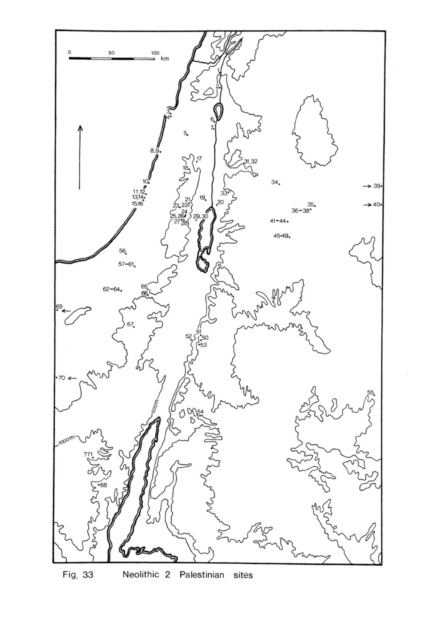
Fig.
33
Neolithic
2
Palestinian
sites
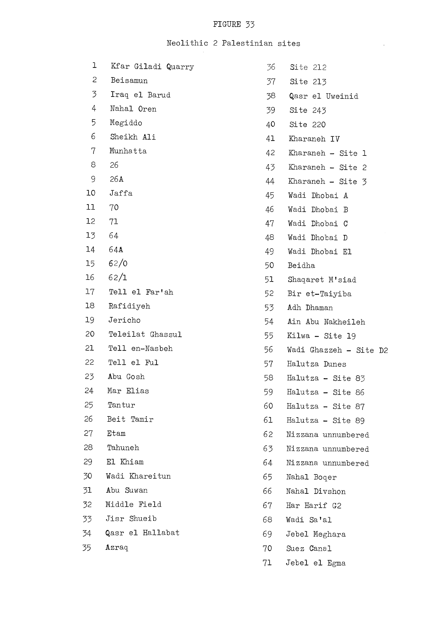
FIGURE
33
Neolithic
2
Palestinian
sites
1
Kfar
Giladi
Quarry
2
Beisamun
3
Iraq
el
Barud
4
Nahal
Oren
5
Megiddo
6
Sheikh
Ali
7
Munhatta
8
26
9
26A
10
Jaffa
11 70
12
71
13 64
14
64A
15
62/0
16
62/1
17
Tell
el
Far'ah
18
Rafidiyeh
19
Jericho
20
Teleilat
Ghassul
21
Tell
en-Nasbeh
22
Tell
el
Ful
23
Abu
Gosh
24
Mar
Elias
25
Tantur
26
Belt
Tamir
27
Etam
28
Tahuneh
29
El
Khiam
30
¥adi
Khareitun
31
Abu
Suwan
32
Middle Field
33
Jisr
Shueib
34
Qasr
el
Hallabat
35
Azraq
36
Site
212
37
Site
213
38
Qasr
el
Uweinid
39
Site
243
40 Site
220
41
Kharaneh
IV
42
Kharaneh
-
Site
1
43
Kharaneh
-
Site
2
44
Kharaneh
-
Site
3
45
¥adi
Dhobai
A
46
¥adi
Dhobai
B
47
¥adi
Dhobai
C
48
¥adi
Dhobai
D
49
¥adi
Dhobai
El
50
Beidha
51
Shaqaret
M'siad
52
Bir
et-Taiyiba
53
Adh
Dhaman
54
Ain Abu
Nakheileh
55
Kilwa
-
Site
19
56
¥adi
Ghazzeh
-
Site D2
57
Halutza
Dunes
58
Halutza
-
Site
83
59
Halutza
-
Site
86
60
Halutza
-
Site
87
61
Halutza
-
Site
89
62
Nizzana
unnumbered
63
Nizzana
unnumbered
64
Nizzana
unnumbered
65
Nahal
Boqer
66
Nahal Divshon
67
Har
Harif
G2
68
¥adi
Sa'al
69
Jebel
Meghara
70
Suez
Canal
71
Jebel
el
Egma
-
212
-
town
wall
which
had
cut
into
PPNB
levels
(Kenyon,
1960,
91).
The
buildings
of
the
PPNB
settlement
were
rectilinear
and
built
of
mud-
bricks
sometimes
on
stone
foundations.
The
bricks
were
parallel-sided
with
rounded
ends
and
had
deep
thumb
prints
in
them
to
act
as
keys
for
mud
mortar.
No
buildings
were
fully
exposed
so
it
is
not
known
what
their
complete
plan
was
but
a
good
idea
of
the
arrangement
of
some
of
them
was
obtained.
They
consisted
of
a
number
of
rooms
arranged
around
a
courtyard.
The
main
rooms
were
very
large,
two
examples
being
6.5
by
h
m
and
7
by
3
m
each
(Kenyon,
1957b,
53),
and
were
subdivided
by
partition
walls
with
two
or
three
openings
in
each
framed
with
wooden
posts.
These
spacious
rooms
were
accompanied by
much
smaller
chambers
and
storage
bins.
The
floors
of
the
rooms
were
covered
with
plaster
painted
red
or
cream
and
then
burnished.
Recent
analyses
have
confirmed
that
the
plaster
was
made
of
lime
(Frierman,
1971,
215;
Gourdin,
Kingery,
1975,
1^-7).
Some
floors
were
covered
with
reeds or
circular
rush
mats (Kenyon,
1957b,
56).
The
courtyards
had
clay
floors
which
were covered
with
ashes
from
numerous
fires
(Kenyon,
1957b,
5*0.
They
formed
the
core
of
each
building
complex
but
it
is
not
certain
if
the
rooms
around them
belonged
to
one
or
more
buildings.
These
complexes
were
frequently
rebuilt
on
a
slightly
different
alignment,
one
of
them
in
site
E
no
less
than
1^
times.
They
apparently
had
a
single
storey and
the same
type
was
found
all
over
the mound.
It
is
probable
that
they
were
family
houses.
One
building
similar
in
other
respects
to
these
houses
had
an
unusual
feature.
A
rectangular
room
had
been
separated
off
and
a
niche
cut
in an
end
wall.
Nearby
a
chipped-out
pillar
of
volcanic
stone
was
found
which
fitted
into
the
niche
(Kenyon,
I957b,
58ff).
Kenyon
has
suggested
that
the
room
was
a
shrine
but
there
is
no
clear
indication
of
what
purpose
it
served.
The
overall
plan
of
another
building
was
different
from
the
usual
houses
even
if
details
of
its
construction
were
the
same
as
in
the
other
buildings.
It
consisted
of
a
series
of
rooms
with
curvilinear
walls
which
surrounded
a
-
213
-
rectangular plastered
space
6
m
long
and
at
least
U
m
wide
(Kenyon,
195^,
51).
This
area
was
believed
to
be
a
central
room.
In
the
centre
of the
floor
of
this
room
lay
a
sunken
basin
plastered
like
the floor
which
had
apparently
been
used
as
a
hearth.
This
building
was
different
from
the
houses;
Kenyon
thought
it
may
have
been
a
temple but
it
could equally
well
have
served
as
a
communal building.
The
houses
of
the
early
PPWB
settlement
were
built
down
the
side
of
the
mound
on
the
evidence
from Trench
I
(Kenyon,
1970,
5U).
Some
were
rebuilt
ten
times
before
there
was
any
change.
Then
a
wall
was
built
near
the
top
of
the
slope.
The
ground
in
front
was
levelled
off
and
the
debris
piled
up
behind
the
wall
so
that
it
formed
a
terrace.
Houses
were then
built
on
top
of
the
terrace
behind
the
wall.
The
line of this
wall
was
irregular
and
since
it
has
only
been
found
in
Trench
I
and
Site
M
it
is
not
known
if
it
encircled
the
site.
The
ground
in
front
of
it
sloped
very
gently
so
it
may
have
been
simply
a
terrace
wall
rather than
a
defensive
work
as
Kenyon
has
suggested.
It
may
be
that
the
settlement
contracted
on
this side
and
that
the
wall
was
built
to
strengthen
the
upper
part of
the
settlement
as
more
debris
accumulated.
Eventually
this
terrace
wall
partly
collapsed
and
a
replacement
was
built
further
to
the
west
(Kenyon,
1970,
55).
It
is
thought
that yet
another
wall
may
ultimately
have
been
built
even
further
out
as
the
settlement
expanded
still
more.
The
dead
of
the
PPNB
settlement
were
buried
beneath
the
floors
of
the
houses
or
in
the
fill
of
abandoned
buildings.
The
graves
frequently
contained
collective
burials
in
which
many
of
the
skeletons
were
disordered
(Kenyon,
195l|.,
U8).
Some
bones
were
articulated
but
others
were
not
and
many
of the
corpses
lacked
skulls.
A
cache
of
seven
skulls was
found
beneath
the
floor
of
a
room
and
two more
under
another
floor
in
the
same
house
(Kenyon,
195?b,
62ff).
The
jaws
had
been
removed
from
all
but
one
of
them
and
the
face
and
base
of
the
skull
covered with
plaster.
One
had
bands
of
paint
on
the
top
of
the
skull.
The
features
were
modelled
naturalistically
with
shells
for
-
211*
-
eyes
to
give
the
skulls
the
appearance of
live
human
beings.
One
other
plastered
skull
was
found
at
the
north
end of
the
mound
(Kenyon,
1970,
53)
making
a
total
of
ten
altogether.
Five
of
these
skulls
have
recently
been
examined
and
were
shown
to
be
adult males
(Strouhal,
1973,
,
,
.
The
practice
of
separating
skulls
from
corpses
and
reburying
the
disor-
dered
skeletal
remains
in
collective
graves
was
widespread
in
the
Levant
in
Neolithic
2.
Restoring
the
faces
of
these
skulls
with
plaster
was
a
more
localised
custom
found
only
at
Jericho,
Tell
Ramad
and,
as
we shall
see,
Beisamun.
One
other
aspect
of
the
treatment
of
detached
skulls
at
Jericho
differed
from
the
practice
on
West
Syrian
and
Euphrates
sites
such
as
Tell
Ramad
and
Abu
Hureyra.
Apart
from
the
ten
plastered
examples
hardly
any
detached
skulls
were
found
buried
in
the
excavated
parts
of
the
settlement
which
suggests
that
they
had
been
gathered
together
and
deposited
in
one or
two
special
.locations.
The
flint
raw
material
for
the
PPNB
chipped
stone
industry
was
quite
as
varied
as
in
the
Proto-Neolithic/PPNA.
Some of
it
was
buff,
brown
or
grey
and
of
obvious
local
derivation.
A
proportion,
however,
was
fine-grained,
often
veined
and
more
lightly
coloured
in
pink,
even
purple
or
a
honey
brown.
We
have
already
noted
that
this
colourful
flint
was
used
at
Jericho
and
at
Nahal
Oren
in
Neolithic
1
but
in
Neolithic
2
large
blade
tools,
particularly
arrowheads,
were
made
of
this
material
at
these
and
a
number
of
other
sites
in
Palestine
and
southern
Syria
such
as
Munhatta
and
Tell
Ramad.
The
sources
of
the
brightly
coloured
flint
have
not
been
determined
but
it
has
tentatively
been
suggested
that
one
may
lie
in
the
hills
that
form
the
south-east
extension
of
Mt.
Carmel
between
the
coastal
plain
and
the
Plain
of
Esdraelon
(Noy
et
al.
,
1973,
86).
Although
the
sources
of
this
flint
have
not
been
located
with
certainty
the
idea
has
been
put
forward
that
this
raw
material
formed
an
object
of
trade
or
exchange
(Mellaart,
1975,
65),
an
hypothesis
which might
be
questioned
if
only
because
the
material
is
heavy
and
since
so
much
has
been
found
on
archaeo-
logical
sites
it
is
difficult
to
see
how
it
might
have
been
transported
before
-
215
-
"beasts
of
"burden
were
domesticated.
It
is
noticeable
that
this
special
flint
was
preferred
for
the
larger
blade
tools,
many
of
which
were
retouched
with
pressure-flaking,
and
this
functional
distinction
in
the use of
raw
material
may
point
to
another
explanation.
Bordes and
Crabtree
have
found
that
long
blades
may
be
pressure-flaked
more
readily
when
the
flint
has
been
heated
(Crabtree,
Butler,
196U,
1;
Bordes,
1969,
197).
This
process
can
alter
the
appearance
of
the
flint
by turning
it
pink
or
other
colours
and
may
also
make
the
surface of
struck
pieces
shiny
and
smooth,
all
of
which
can
be
seen
on
the
distinctive
Neolithic
2
flint.
This
suggests
that
the
material
is
medium-grained
flint
of
the
usual
kind
found
in
beds
in
the
lime-
stone
of
Palestine
and
southern
Syria
or
as
nodules
in
wadis
which
has
been
collected
and
then
heated
to
make
it
easier
to
work.
This
would
also
explain
why
no
sources
of
this
material
have
been
identified
with
certainty.
Most of
the
flint tools
in
the
PPNB
at
Jericho
were
made
on
blades
struck
off
double-ended
cores
of
which
some
were
keeled.
The
basic
core
technique
was
thus
exactly
the
same
as
on
most
Neolithic
2
sites
in
the
West
Syrian
and
Middle
Euphrates
groups.
Some
of
the
most
common
tool
types
were
the
arrowheads.
Almost
all
were
tanged
but
some
had
pairs
of
side
notches
as
well,
quite
like
examples
on
West
Syrian
sites.
Another
group
had
long
tangs
with
pronounced
wings
or
barbs
formed
by
deep
notches
on
either
side
of
the
tang.
These
appear
to
have
been
a
specifically
Palestinian
type.
A
third
group
had
tangs
defined
by
shoulders
or
a
simple
narrowing
of
the
blade
at
the
tang
end.
These
types
were
common
on
West
Syrian
sites
and
were
found
on
other
sites
throughout
the
Levant.
The
tangs
of
most
of
the
arrowheads
were
heavily
retouched
with
pressure-flaking
but
although
some
also
had
pressure-flaking
on
the
rest
of
the
blade
most
were
only
lightly
retouched
at
the
tip.
The
other
main
class
of tool
was
the
sickle
blades.
These
had
nibbled
or
finely-denticulated
cutting
edges
but
were
usually
not
otherwise
retouched.
Dihedral
and
angle
burins
on
blades were
fairly
common.
Borers
on
blades
were
-
216
-
also made
but
these
were
quite
rare.
Scrapers
of
all
types
were
uncommon especially
when
compared
with
sites
further
north.
Some
discoids
were
made
on
core
tablets
but
there
were
few
other
flake
scrapers
or
end-scrapers
on
blades.
Core
tools
were
also
exceed-
ingly
scarce.
There
were
no large
core
tools
at
all
and only
one
or
two
small
flaked
axes
with
a
tranchet
cutting
edge.
Small
greenstone
axes
were
found
which,
like
these
flaked
flint
ones,
may
have
been
used
for
woodworking.
About
]%
of
the
chipped
stone
industry
at
Jericho
was
of
obsidian
(Renfrew
et_al.
,
1966,
61).
Two
pieces
analysed
by
Renfrew
and
his
colleagues
were
found
to
be
from
the
Ciftlik
source
(Renfrew
et
al.,
1966,
table
1)
as
was
a
third
piece
recently
analysed
in
the
Bradford
programme.
One
other
piece
analysed
at
Bradford
was of
green
obsidian
but
it
could
not
be
ascribed
to
any
known
source.
It
did
not,
however,
come
from
Ciftlik
so
we
now
know
that
obsidian
from
at
least
two
sources
was
reaching
PPNB
Jericho.
The
ground
stone
tools
at
Jericho
were
numerous and
varied.
The
most
characteristic
objects
were
the
open-mouthed
querns
(Kenyon,
1957b,
57)
»
some
of
which
were
stepped,
a
type
which
has
since
been
found
at
Munhatta
and
Tell
Ramad.
Plano-convex
rubbers
were
used
with
these
querns
to
grind
grain.
Hammerstones,
stone
balls
and
stone
polishers
were
all
made
and
also
pestles
which
are
rare
on
other
Neolithic
2
sites.
Dishes
and
bowls
were
carved
from
a
local
soft
limestone
and
some
were then
given
a
fine polish.
Among
the
other
stone
tools
were
spindle whorls
and
weights
which
may
have
been
used
in
simple
looms.
Bone
tools
such
as
borers
and
spatulae
were
made
but
these
were
less
abundant
than
in
the
PPNA
at
Jericho
and
also
less
common
than
on
most
West
Syrian
and
Middle
Euphrates
Neolithic
2
sites.
One
of
the
more
unusual
groups
of
finds
from
PPNB
Jericho
was
a
series
of
stylised
anthropomorphic
plaster
figures.
Fragments
of
several
of
these
were
found
in
Square
DII
(Kenyon,
1960,
92).
One
which
could
be
reconstructed
from
the
waist
up
was
almost
life-sized
and
had
a
rectangular
head
but
no
indication
of
facial
features.
It
was
decorated
with
red,
brown
and
cream
-
217
-
paint.
Two
groups
of three
plaster
figures
were
found
by
Garstang
(1935,
166)
in
Neolithic
levels
at
the
northern
end
of
the
site
but
their
precise
stratigraphic
position
was
uncertain.
It
now
seems
likely
that
they
can
be
associated with
the
figures
found
in
Kenyon's
excavations and
so
dated
to
the
PPNB
phase
of
occupation.
The groups
each
consisted
of
a
life-sized
man
and
a
smaller
woman
and
child.
Garstang
was
able
to
recover
only
one
head
of
these
figures
which
was
thin
and
spade-shaped
like those
found
by
Kenyon but
its
face
was
naturistically
modelled
as
were
the
other
plaster
fragments
which
could be
identified,
with
eyes
made of
shells.
The
face
was
made
more
life-
like
still
with
painted
lines
to
represent
hair
on
the
forehead
and
a
beard.
The
modelling
of
these
figures
with
plaster,
shells
and
paint
reminds
one
of
the
way
the
plastered
skulls
were
made
but
there
is
no
indication
that
the
two
were
used
together
like
the
plaster
figures
and
plastered
skulls
at
Tell
Ramad.
For
the
moment
the
function of
the
Jericho
plaster
figures
remains
obscure.
Clay
was
used
to
make
human
and
animal
figurines
(Kenyon,
1957b,
59ff),
finds
which
are.common
to
most
excavated
Neolithic
2
sites.
There
were
also
objects of
adornment
such
as
shell
and
malachite
beads;
the
raw
material
for
the
latter
was
probably
brought
up
from
the
Wadi
Arabah.
Turquoise
was
imported
from
Sinai and
cowrie
shells
from
the
Mediterranean
or
Red
Sea.
A
little
oval
piece of
bone
carved to
resemble
a
human
face
with
two
holes
for
eyes
may
have
been
a
bead
or
button.
The
1/4
C
determinations
for
PPNB
Jericho
are
even
more
difficult
to
inter-
pret
than
those
for
the
preceding
phases.
Six
have
been
made
altogether
and
of
these
two
from
the
British
Museum
and three
from
the
Philadelphia
laboratories
probably
give
results
approaching
the
true
age
of
the
samples.
Unfortunately
when
considered together
they
are
contradictory.
The
British
Museum
determina-
tions
of
7220
±
200
B.C.
BM-115
(Radiocarbon
5,
1963,
107)
and
6760
±
150
B.C.
BM-253
(Radiocarbon
11,
1969, 291)
are
thought
to
date
the
middle
of
the
PPNB
phase.
Yet
two
of the
Philadelphia
dates
which
should
date
early
PPNB
levels
-
218
-
are
6660
±
75
B.C.
P-380
and
6708
±
101
B.C.
P-381
(Radiocarbon
5,
1963,
It
seems
that
once
again
the
Philadelphia
determinations
are
several
centuries
later
than
those
from
the
British
Museum.
One
other
sample
stratified
above
P-380
in
Site
E
gave
a
date
of
7006
±
103
B.C.
P-382
(Radiocarbon
5,
1963,
Qk}
which
only
adds
to
the
confusion.
It
is
not
possible
from
these
dates
to
make
an
accurate estimate
of
when PPNB
Jericho
was
resettled
or
when
it
was
abandoned
although
given
the
clustering
of
the
determinations
it
is
probable
that
the
total
duration
of
the
phase
may
have
been
nearer
a
half
than
a
whole
millennium.
One
might
guess
that
the
PPNB
settlement
began
about
7000
B.C.
and
lasted
until
6500
B.C.
or
a
little
after
but
this
estimate
could
be
in
error
by
several
centuries.
One
inference
from
this
would
be
that
Jericho
was
deserted
for
about
half
a
millennium
between
PPNA
and
PPNB.
PPNB
Jericho
was
apparently
abandoned
well
before
the end
of
the
7th
millennium
and
was
not
resettled
until
much
later.
Jericho
was
occupied
during
Neolithic
2
and
the
general
character
of
the
remains
on
the
site
link
it
culturally
with
Neolithic
2
sites
in
the
West
Syrian
and
Middle
Euphrates
groups.
There
are
the
rectilinear
mud-brick
build-
ings
and
plaster
floors,
a
basically
similar
flint
industry
though
with
some
typological
differences and
the
Neolithic
2
burial
customs
though
again
with
certain
local
special
features.
These
broad
similarities
place
PPNB
Jericho
firmly
within
Neolithic
2
of
the
Levant but
the
particular
local differences
we
have
noted
mean
that
Jericho
must
be
regarded
as
a
site
within
a
third
regional
cultural
grouping.
This
third
regional
group
consists
of
sites
in
Palestine.
Nahal
Oren
The
upper
layer
at
Nahal
Oren,
layer
I,
was
also
occupied
in
Neolithic
2.
This
layer
covered
only
the
centre
and
upper
parts
of
the
site
(Stekelis,
Yizraely,
1963,
2;
Noy
et
al.,
1973,
78)
and was
much
disturbed.
Nothing
was
found
to
indicate
that
the
site
had
been
abandoned
between
layers
II
and
I
so
it
is
thought
that
the
site
continued
to
be
occupied without
a
break.

-
219
-
Layer
I
varied
from
0.5
to
1.5
m
in
depth
which
may
indicate
that
the
site
was
occupied
for
a
short
period
or
that
occupation
was
intermittent
as
I
have
suggested
for
the
earlier
layers.
Two
stone-walled
structures
were
excavated
on
the
site
but
it
is
likely
that
others
existed which
have
since
been
destroyed.
One
was
a
large
building
paved
with
flat
stones
(Stekelis,
Yizraely,
1963,
2).
This
contained
a
small
inner
chamber
defined
by
another
stone
wall.
The
structure
found
in
the
recent
excavations
had
been built
at
the
top
of
the
site
on
a
specially
levelled
surface.
This
building
which
is
thought
to
have
been
a
house
was
approximately
rectangular
in
shape
and
had
a
clay
floor.
At
a
later
stage
this
building
was
reused
as
a
burial
place.
A
rough
curved
stone
wall
was
erected
inside
which
marked
off
part
of
the
room.
Within
the
chamber
formed
by
the
wall
four
bodies, three
adults
and
a child,
were
buried
in a
crouched
position
and
covered
with
stones
(Noy
et
al.,
1973,
T9ff).
The
skulls
of
the
child
and
one
of
the
adults
were
missing
although
the
mandibles
had
been
left
in
place.
The
skeletons
were
preserved
almost
intact
so
they
could
not
have
been
much
disturbed
when
the
skulls
were
removed. The
two
which
retained
their
skulls
were
each
buried
with
a
shell
bead
and
polished
pebble.
In
addition
one
had
a
bifacially
retouched
flint
knife
in a
bone handle
and
the
other
a
bone
spatula.
Fragments
of
a
fifth
burial
were
found
in
the
same
building
on
the
other
side
of
the
curved
wall
but
this
had
been badly
damaged
by
subsequent
disturbance.
It
had
a
dentalium
bracelet
around
one
wrist.
The
flint
tools
were
made
of
the
same
varied
raw
material
obtained
in
the
vicinity
as
in
the
earlier
layers.
A
very
little
obsidian
was
used
as
in
layers
III
and
II
but
the
sources
from
which
it
was
obtained
are
not
known.
Many of
the
larger
tools
at
Nahal
Oren were
made
on
blades
struck
from
double-
ended
cores
but
there
was
a
significant
proportion
of
small
artifacts
made
on
little
blades
and
flakes
derived
from
prismatic
cores.
This
is
partly
because
much
of
the
available'flint
was
in
the
form
of
small
nodules
but
it
probably
also
represents
some
continuity
in
tradition
from
layer
II.
-
220
-
The two
main
classes
of
flint
artifacts
vere
tanged
arrowheads
and
sickle blades.
Some
of
the
arrowheads
had
pairs
of
notches
along
the
"blade
while
others
were
winged
or
had
clearly
defined
shoulders.
The
notched
arrow-
heads
had
relatively
little
retouch
"but
some
of
the
others
were extensively
retouched
with
pressure-flaking.
This
range
of
types
closely
resembles
the
arrowheads
from
PPNB
Jericho.
The sickle
blades
were
usually
quite
long
with
a
little
nibbled
or
finely
denticulated
retouch.
These
are
similar
to
the
Neolithic
2
sickle
blades
at
Jericho
and
on
West
Syrian
sites.
There
were
a
few
angle
and
dihedral
burins,
abruptly
retouched
borers
on
blades
and
scrapers
on
blades
and
flakes
but
all
these
types
were
relatively
scarce.
As
.in
the
levels
below
there
was
much
admixture
of
artifacts
from
earlier
phases.
Flint,
basalt
and
limestone
axes
and
adzes
were
quite
common
at
Nahal
Oren.
The
flint
axes
were
of
two
types,
small
ones
flaked
all
over
with
a
tranchet
edge
and
larger
flaked
axes
with
a
rounded
polished
cutting
edge.
The
other
stone
axes
were
finished by
flaking,
pecking
and
polishing.
Some
nephrite
objects
were
found
in
the
earlier
excavations
(Stekelis,
Yizraely,
1963,
2)
which
may
have
been
axes.
The
querns
in
layer
I
at
Nahal
Oren
were
different
from
the
hollow
querns
of
layers
IV
to
II
as
they were
stepped
with
an
open
end
(Stekelis,
Yizraely,
1963,
k).
They
were
thus
like
the
querns
at
PPNB
Jericho
and
Tell
Ramad.
These
were
accompanied
by
limestone
and
basalt plano-convex
rubbers.
Lime-
stone
bowls
and
dishes
were
very
common
at
Nahal
Oren.
The
usual
range
of
bone
points
and
spatulae
was
used
at
Nahal
Oren
I
and
these
tools
were
a
little
larger
and
more
robust
than
those
from
earlier
layers
One
unusual
find
was
an
equid phalange
with
a
vertical
hole
drilled
in
the
top
and
pairs
of
holes
on
either
side
of
the
articulation;
it
has
been
suggested
that this
may
have
been
the
body
of
a doll.
Many tiny
beads
were
found
in
the
flotation
residue
of
the
recent
excavation.
Some
were
little
shell
discs
and
others
sections
of
dentalium
(Noy
et
al.,
1973,
88).
Cylindrical
bone
and
-
221
-
stone
beads
were
also
made.
No
1If
C
determinations
have
"been
obtained
for
Nahal
Oren
I
so
the
date
of the
occupation
can
only be
established
by
typological
comparisons
with
other
sites. The
general
character
of
the
remains
places
Nahal
Oren
I
firmly
within
Neolithic
2
in
the
Levant and
therefore
within
the
7th
millennium.
The
characteristics
of
the
flint
industry
and
the
typology
of
the
arrowheads
in
particular
are
so
like
PPNB
Jericho
that
it
is
reasonable
to
suppose
that
both
sites
were
occupied
about
the
same
time.
This
would
mean
that
Nahal
Oren
I
was
probably
inhabited
in
the
early
or
middle
7th
millennium
B.C.
El
Khiam
El
Khiam
is
the
third
site
in
Palestine
at
which
Neolithic
2
remains
have
been
found
stratified
over
Neolithic
1
occupation.
This
material
was
recovered
from
the
topmost
level,
level
A, in
Neuville's
excavations.
This
level was
subdivided
into
three,
A1
which
was
a
surface
deposit
containing
mixed
Neolithic
2,
Chalcolithic,
Byzantine
and
Islamic
artifacts,
and
A2
and
A3
which
were
Neolithic
2
deposits
although
they
also
contained
some
material
from
earlier
levels
(Perrot,
1951,
166,
17^-K
These
levels
corresponded
to
Echegeray's
levels
2
(Prototahunian)
and
1
(Tahunian)
which
was
subdivided
into
1a
and
1b
(Echegeray,
1966,
71,
83).
The
only
structures
in
these
deposits
were
a
straight
stone
wall
and
some
hearths
found
by
Echegeray
in
level
1b
(Echegeray,
1966,
pis.
II,
III).
The
raw
material
for
the
flint
tools
was
obtained
locally
as
in
earlier
levels.
A
very
little
obsidian
was
imported
in
the
form
of
blades.
One
piece
from
level
6
analysed
by
neutron
activation
proved
to
be from
a
source
in
the
Acigo"!
region
(Wright,
Gordus,
1969,
81).
Most
of the tools
were
made
on
blades
but
these
were
struck
off
pyramidal
cores
and
so
were relatively
small.
Arrowheads
were
one
of
the
most
numerous
classes
of
tools
and
there
were
several
types
of
these
(Perrot,
1951, figs.
71,
10-2*1;
72).
Most
were
tanged
although
there
were
a
few
pressure-flaked
leaf-shaped
points.
Some
of
the
tanged
arrowheads
had
pairs
of
notches
along
the
blade
while
most of
the others
-
222
-
had
wings
or
sharply-defined
shoulders.
These
types
of
arrowheads
were
found
both
at
Nahal
Oren
I
and
PPNB
Jericho
but
the
El
Khiam
examples
were
frequently
extensively
retouched
with
pressure-flaking.
Burins
were
very
common
in
these
levels
at
El
Khiam,
the
principal
types
being
angle
and
dihedral
burins.
End-scrapers
on
blades
were
also
numerous
but
outnumbered
by
small
flake
disc
scrapers
(Perrot,
1951,
171).
Other
types
such
as
sickle
blades
were
less
frequent.
These
were
backed
irregular
blades
of
which
only
a
few
had
any
edge
retouch.
This
type
is
different
from
those
found
on
other
Palestinian
and
West
Syrian
sites
partly
because
a
different
core
technique
was
used.
The
scarcity
of
sickle
blades
may
reflect
the
unsuitability
of
the
environment
for
agriculture.
Some
larger
flint
tools
were
found,
among
them
flaked
tranchet
axes,
chisels
and
picks.
There
were
also
a
very
few
flaked
and
polished
axes.
Ground
stone
tools
were
abundant.
Most
of
these
were
made
of
local
lime
stone
but
a
few
were
of
basalt
probably
obtained
from
northern
Palestine
or
Transjordan.
These
included
pestles
and
mortars
as
well
as
rubbers
and
querns.
There
were
one
or
two
decorated
stone
objects
and
also
fragments
of
a
few
limestone
bowls.
No
mention
was
made
of
other
finds
in
the
reports
so
it
does
not
seem
likely
that
many
bone
tools
or
decorative
items
were
found.
This
whole
deposit
at
El
Khiam
was
no
more
than
1.5m
deep
although
one
should
remember
that
some
of
the
original
material
would
have
washed
down
the
slope
of
the
terrace.
The
site
was
probably
occupied
intermittently
in
Neolithic
2
like
Nahal
Oren
though
there
are
indications
that
El
Khiam
con
tinued
to
be
used
for
a
longer
period.
If
one
considers
the
typology
of
the
arrowheads
in
level
A
then
it
is
clear
that
they
include
both
notched
arrow
heads
recalling
those
of
Neolithic
1
and
heavily
pressure-flaked
examples
which
in Syria
where
the
deposits
are
well-dated
would
be
late
7th
or
even
6th
millennium
in
date.
Throughout
the
Levant
there
was
a
tendency
for
pressure-flaking
to
be
used
more
extensively
towards
the
end
of
Neolithic
2
and
into
the
6th
millennium.
While
this
cannot
be
taken
as
a
precise
-
223
-
chronological
indicator
the
presence
of
many
heavily
pressure-flaked
arrow
heads
at
El
Khiam
does
suggest
that
the
site
continued
to
"be
visited
after
occupation
at
Nahal
Oren
I
and
PPNB
Jericho
had
ceased.
Wadi
Khareitun
Neuville
excavated
another
site
on
the
slope
directly
across
the
Wadi
Khareitun
from
El
Khiam.
The
sequence
here
was
the
same
as
at
El
Khiam
and
included
some
Neolithic
2
occupation
(Perrot,
1951,
17*0-
Munhatta
Munhatta
lies
on
the
west
side
of
the
Jordan
valley
about
11
km
south
of
the
Sea
of
Galilee.
It
is
situated
on
a
high
terrace
at
the
point
where
the
Wadi
Bireh
opens
out
into
the
Jordan
valley.
The
depth
of
deposit
on
the
site
amounts
to
some
3
m
(Perrot,
196*1,
325)
which
has
"been
divided
into
six
archaeological
layers,
levels
6
to
3
which
are
Neolithic
2
in
character
and
levels
2
and
1
which
"belong
to
the
Late
Neolithic
(Moore,
1973,
36)
and
Chalcolithic
respectively.
Erosion
of
the
site
has always
"been
severe
and
in
consequence
none
of
the
"buildings
is
preserved
very
high.
Level
6
consisted
of
the
remains
of
the
earliest
settlement
founded
on
the
natural
subsoil.
There
were
earth
floors
laid
on
beds
of
stones,
probably
the
floors
of
dwellings
(Perrot,
1966c,
271),
hearths
and
much
occupation
debris.
The
first
structure
found
in
level
5
"was
a
long
wall
which
ran
across
the
site
from
east
to
west
(Perrot,
196U,
325).
The
foundations
were
built
of
large
stones and
the
superstructure of
mud-bricks.
To
the
south
of
this
wall
there
was
a
paved
area
and
also
a
floor
with
a
number
of
hearths
(Perrot,
1967,
267).
A
large
platform
was
also
found
made
of
five
large
basalt
slabs
with
channels
cut
in
them.
Associated
with
this
structure
was
a
large
trough
with
a
pebble
floor.
The
purpose
of
these
structures
is
unknown
but
one
would
suppose
that
they
were
used
for
some
craft
process.
The
buildings
in
level
h
had
a
single
rectangular
room
with
a
plaster

-
22U
-
floor
which
in some
instances
was polished.
These
rooms
had
walls
at
least
^
m
long
made of
mud-brick reinforced
with
stone
footings
along
the
outer
edge
(Perrot,
1966b,
52).
The
north
wall
of
each
room
had
a
plastered
niche
(Perrot,
1965,
2k9)
like
that
found
in
one
of
the
buildings
at
Jericho but
without
the
upright
stone.
These
buildings
were
separated by
narrow
passages
and
courts
in
which
were
found
hearths
and
the
vestiges
of
stone
structures
which
may
have
had
a
domestic
function.
A
number
of
plaster
floors
were
also found
in
level
3,
presumably
the
remains
of
single-roomed
structures
similar
to
those
in
level
k.
These
were
accompanied by
buildings
of
a
different
kind
and
of
uncertain
purpose.
One
of
these
buildings
had
a
large
circular
court
paved
with
stones
which
may
have
been
partially
roofed
(Perrot,
196^,
327).
It
was
surrounded
by
a
ring
of
chambers
each
about
3
by
5
or
6
m
in
size.
Traces
of
another apparently
similar
structure
were
found
a
little
to
the
west
(Perrot,
1965,
2^9)
and
a
third
in
the
northern
part
of the
site (Perrot,
1966c,
269).
The
plaster
floor
buildings
of
level
h
contained
hearths
and
benches
which
gave
them
the
appearance
of
dwellings,
an
interpretation
strengthened
by
the
fact that
they
were
the
only
numerous and
substantial
structures
found
in
this
level.
Their
presumed
successors
in
level
3,
the
plaster
floors,
were
also
quite
common. This
makes
it
likely
that
the
large,
unusual
circular
buildings
had
another,
perhaps
communal
function.
The
inhabitants
of
Munhatta
3
abandoned
the
site
and
in
the
subsequent
weathering
its
remains
were
gradually
hidden
beneath
a
layer
of
sandy
soil
(Perrot,
1966c,
269).
The
site
had
all
but
disappeared
when
it
was
resettled
much
later
on
(Perrot,
1966b, ^9),
an
indication
of
the
long
period which elapsed
between
Munhatta
3
and
2.
Most
of
the
flint
tools
at
Munhatta
were
made
on
blades
struck
from
keeled
and
other
double-ended
cores
(Perrot,
1966b,
53, fig.
3,
10).
The
most
numerous
group
was
the
arrowheads
all
of
which
had
pronounced
tangs. The
principal
types
had
wings
or
sharp
shoulders
and
some
even
had
pairs
of
barbs
on
the
tang
-
225
-
itself
(Perrot,
1966b,
fig.
k,
9»
10).
Some
arrowheads
were leaf
or
diamond-
shaped
without
shoulders
"but
relatively
few
were
notched.
These
tools
were
usually
retouched
by
pressure-flaking which
was
often
quite
extensive.
Sickle blades
were
also
very
common and
these
had
finely-denticulated
cutting
edges
with
little
other
retouch.
The
remaining
tools
were much
less
abundant
but
they
included
the
same
types
found
on
other
Palestinian
Neolithic
2
sites:
end-scrapers
on
blades
and
flakes,
dihedral
and
angle
burins
and
borers.
Large
flaked
tools
were
not
apparently
found
in
any
numbers
at
Munhatta
as
they were
at
Jericho.
Very
little
obsidian
was
found
at
Munhatta.
A
piece found
in
level
6
came
from
source
1e-f
near
AcigQl
(Wright,
Gordus,
1969,
81),
the
same
area
as
the
piece
analysed
from
El Khiam.
Obsidian
from
this area
is
very
rare
on
Neolithic
2
sites
in
the
Levant
as
much
of
the
Cappadocian
obsidian
which
was
used
came
from
Ciftlik.
Ground
stone
tools
were
particularly
abundant
at
Munhatta.
There
were
the
same
stepped
and
open-ended
querns
as
at
Jericho
and
elsewhere
together
with
rubbers,
grooved
stones,
polishers,
pestles
and
mortars
made
of
basalt
or
limestone
(Perrot,
1966b,
58).
Fragments
of
stone
dishes
and
bowls
were
also
found
but the
only
objects
of
adornment
were
a
few
discoid
and
cylindrical
greenstone
beads.
Bone
tools
were
recovered
at
Munhatta
but
these
have
not
been
discussed
in
any
of
the
reports
which
have
appeared
so
far
and
I
have
not
examined
them.
Clay
figurines
of
humans and
animals
were
another
very
common
find
at
Munhatta.
Many
of
the
anthropomorphic
figurines
were
of
similar
shape
and
somewhat different
from
those
found
on
other
sites.
Each
was
made
of
a
clay
sausage
flattened
at
one
end
to
make
a
base.
The
other
end
was
pinched
flat
and
little
pieces
of
clay
were
applied
to
form
the
eyes
and
nose.
Both
males
and
females
were
represented.
The
animals
were
usually
horned
quadrupeds,
some
of
which
had
a
marked
dorsal
ridge.
Some
were
obviously
cattle
and
others
may
have
been
pigs
or
sheep
and
goats.
Pawns
and
other
abstract
shapes
were
quite
common
as
at
Ramad.
-
226
-
Two
llf
C
determinations
vere
obtained
from
soil
samples
in an
attempt
to
date
the
Neolithic
2
occupation.
These
gave
results
of
5^20
±
hOO
B.C.
M-1792 and
7210
±
500
B.C.
M-1793
(Radiocarbon
12,
1970,
178,
179).
These
dates
have
large
stated
errors
because
of
the
unsatisfactory
nature
of
the
material
dated
and
do
not
agree
with
each
other.
They
give
us
no
more than
a
very
general
idea
of
the
age
of the
deposits.
One
can
obtain
a
more
precise
idea
of
the
time
when
the
site
was
occupied
from
typological
comparisons
of
the
artifacts
found
there.
The
material
is
all
Neolithic
2
in
character
which
may
be
equated
in
general
terms
with
PPNB
Jericho
yet
there
are
certain
aspects
of
the
Munhatta
flint
industry
which
are
distinctive.
The
arrowhead
types
are
quite
elaborate
compared
with
those
at
Jericho
and
Beidha
VI
to
I
and
have
much
more
pressure-flaking
than
on
these
two
dated
sites.
Thus
although
the
occupation
at
Munhatta
may
have
overlapped
with
the
sequences
at
Jericho
and
Beidha
it
probably
continued
into
late
Neolithic
2.
This
would
mean
that
the
site
was
occupied
in
the
middle
or
late
7th
millennium
B.C.
Relationships
between
Palestinian,
West
Syrian
and
Middle
Euphrates
sites
in
Neolithic
2
The
Neolithic
2
sites
in
Palestine
which
I
have
discussed
are
closely
related
culturally
to
Jericho
and
may
be
dated
by
the
PPNB
Jericho
Carbon
1U
determinations.
Thus
all
of
them
appear
to
have
been
occupied
during
the
7th
millennium
which
makes
them
broadly
contemporary
with
the
Neolithic
2
West
Syrian
and
Middle Euphrates
sites.
The
Palestinian Neolithic
2
sites
and
those
further
north
share
certain general
cultural
traits
like
the
rectilinear
buildings
with
plaster
floors
and
burial
customs
which
embrace
single
inhuma-
tions
,
secondary
collective
burial
and
special
treatment
of
skulls.
Their
flint
industries
are
based
on
the
same core
techniques
and the
same
range
of
tool
types
is
found
on
most
Neolithic
2
sites,
tanged
arrowheads
everywhere,
sickle
blades
in
abundance
on
Palestinian
and
West
Syrian
sites,
end-scrapers,
angle
and
dihedral
burins,
borers,
and
flaked
and
polished
axes
and
adzes
on

-
227
-
some
sites.
Ground
stone
rubbers
and
querns
are
ubiquitous
as
are fine
stone
bowls
and
dishes.
The
Palestinian
sites
thus
form
part
of
a
single
Levantine
cultural
entity
in
Neolithic
2
yet
in
their
material
remains
they
show
considerable
individuality.
The
plans
of
the
buildings
at
Jericho,
Nahal
Oren
and
Munhatta
are
different
from
those
at
Tell
Ramad
and
Abu
Hureyra
for
example.
There
are
certain
variations
in
burial
rites
on
the
Palestinian
sites,
not
least
the
practice
of
modelling
faces
on
skulls
of
the
deceased
which
seems
to
have
been
confined
to
sites
in
Palestine
and
Tell
Ramad
only
a
little
to
the
north-
east.
The
flint
industries
of the
Palestinian
sites
have
their
own
idiosyn-
cracies,
one
of
which
is
the
making
of
tanged and
winged
arrowheads,
a
type
rare
anywhere
else.
Tranchet
axes
are
another
Palestinian
type
rarely
found
on
sites
further
north.
The
stepped,
open-ended
querns
are
found
on
most
Palestinian
sites
but
only
at
Tell
Ramad
to
the
north.
On
the
other
hand
the
white
plaster
ware
which
is
so
common
on
later
Neolithic
2
West
Syrian
and
Middle
Euphrates
sites
is
not
found
in
Palestine,
unless
a
report
of
a
few
fragments
being
found
at
Munhatta
is
corroborated.
These
cultural
differences
are
sufficiently
marked
for
us
to
place
the
Palestinian
sites
in
a
third
regional group
within
Neolithic
2
of
the
Levant.
Although
the
Palestinian
sites
form
a
distinct
regional
group
some of
their characteristic
cultural
traits
are
found
at
Tell
Ramad
and
other
sites
in
the
West
Syrian
group.
These
two
regional
groups
have
particularly
close
cultural
links
and
form
almost
a
cultural
continuum
along
the
coast
and
immediate
hinterland
of
the
Levant.
When
Kenyon
excavated
Jericho
it
became
apparent
that
there
was
a
long
gap
in
occupation
between
the
PPNA
and
PPNB
settlements.
The
material
remains
of
the
PPWB
settlement
also
appeared
to
be
quite
different
from
those
of
the
PPNA.
Jericho
was the
only
site
in
Palestine
which
provided
a
long
and
well-
defined
Neolithic
sequence.
All
the
other
sites
were
either
settlements
occupied
for
much
shorter
lengths of time
or
surface stations
and
none
of
-
228
-
them had
as
full
an
artifact
inventory
as
Jericho.
Their cultural
and
chronological position
could
only be
fixed
by
the
Jericho
sequence.
None
of
them
appeared
to
provide
a
link
between
the
PPNA
and
PPNB
at
Jericho
so
it
was
thought
that
the
PPNB
was
a
culture
that
had
originated
elsewhere
and
been
introduced
into
Palestine
by
immigrant
groups.
When
excavations
began
at
Hacilar
and
Catal
HUyUk
in
Anatolia
archaeologists
noted
that
PPNB
Jericho
had
certain general
traits
in
common
with
these
sites.
It
was
then
suggested
that
some
unknown
culture
in
Syria
provided
a
link
between
the
Anatolian
and
Palestinian
sites
and
that
the
PPNB
in
Palestine
was
introduced
from
there
.(de
Vaux,
1966,
13;
Kenyon,
1969,
159).
Since
then
many
Neolithic
sites
have
been
found
in
Syria
and
some of
them
have
been
excavated.
The
Neolithic
sequence
is
fairly
clear
now,
at
least
in
the
Damascus
basin
and
along
the
Euphrates.
These
two
regions
enjoyed
an
unbroken
local
development
of
culture
within
the
wider
Levantine
province
throughout
Neolithic
1
and
2.
It
can
now
be
seen
that
the
PPNB
at
Jericho
was
distinct
from
Neolithic
2
further
north
and
could
not
have
developed
from
it
for
both
crystallized
about
the
same
time.
Jericho
is
still
the
type-site
for
the
Neolithic
in
Palestine
but more
is
now known
about
other
sites
in
the
region.
Although
there
was
a
long
gap
in
occupation
at
Jericho
between
PPNA
and
PPNB
there
was
no
such
sharp
break
in
the
sequences
at
Nahal
Oren
and
El Khiam.
When
the
material from
these
two
sites
is
considered
and
also
that
from
Jericho
now
that
the
study of
it
is
far
advanced
we
can
see
that
there
was
considerable continuity
of
culture
from
Neolithic
1
to
2
within
Palestine.
Some
characteristics
of
the
Neolithic
2
chipped
stone
industry
in
Palestine
had
already
been
developed
at
these
sites
in
Neolithic
1.
Double-ended
cores
were
used
at
both Nahal
Oren
and
Jericho
in
Neolithic
1
and
a
number
of
true
blade
tools
had
been
made
on
the
products
of
these
cores.
Squamous
pressure-flaking
was
also
used
at
these
two
sites.
Flaked
tranchet
axes
were
first
made
in
Neolithic
1
although
they
are
usually
thought
of
as
typical
of
Neolithic
2
in
Palestine.
Many
of
the
-
229
-
ground
stone
tools
and
stone
vessels
were
similar
in
Neolithic
1
and
2
as
were
the
bone
tools.
The
typical
"burial
customs
of
Neolithic
2
were
also
developed
earlier
for
at
both
Jericho
and
Nahal
Oren
skulls
were
removed
from
skeletons
in
Neolithic
1.
The
most
striking
difference
between
PPNA
and
PPNB
at
Jericho
was
the
plan
of
the
buildings.
This
is
still
true
but
there
is
no
longer
any
need
to
look
further
than
the
southern
Levant
for
the
origins
of
the
new
rectilinear
style
of
construction.
At
both
Nahal
Oren
and
Beidha
there
was
a
swift change
from
circular
to
rectangular
structures
and
the
change
was
equally
rapid
at
Mureybat
in
the
north
even
if
at
each
site
the
change
happened
at
a
different
time.
It
seems
that
the
alteration
in
building
plan
took
place
on
Palestinian
sites
during
the
centuries
when
Jericho
was
unoccupied
and
that
when
the
site
was
resettled
about
7000
B.C.
the
inhabitants
built
their
houses
in
the
then
current
rectilinear
style.
The
gap
in
the
sequence
at
Jericho
is
still
marked
but
there
is
no
reason
to
suppose
that
all
cultural
development
ceased
in
Palestine
during
this period.
Quite
the
reverse
seems
to
have
occurred:
the
culture
of
Neolithic
1
in
Palestine
was
transformed
into
that
of
Neolithic
2
within
the
region
as
was
happening
further
north.
Palestine
continued
to
be
occupied
during
the
transition
even if
most
of
the
known
sites
were
inhabited
for
such short periods
that
long
cultural
sequences
are
rarely
found.
I
will
now-briefly
review
the
evidence
for
Neolithic
2
occupation
at
other
sites
in
Palestine.
The
sites
are
many
but
most
of
them
are
only
known
from
surface
survey.
Intense
exploration
of
this
region
is
continuing and
new
sites
are
being
discovered
every
year
but
information
about
these
dis-
coveries
is
disseminated
slowly.
Other
sites
were
discovered
long
ago
and
remain
unpublished,
their
surface
collections
dispersed.
Some
of
these
have
doubtless
been
forgotten.
Since
our
information
about
these
sites
is
so
uneven
I
shall
not
attempt
to
mention
every
one
discovered
but
simply
those
in
each area
for
which
information
is
readily
available
in
the
published
-
230
-
sources
and
in
unpublished
museum
collections
which
I
have
examined.
Mt.
Carmel
Iraq
el
Barud
(Sefunim)
Iraq,
el
Barud
is
a
cave
which
lies
above
the
Wadi
Sefunim
on
the
west
side
of
Mt.
Carmel
about
10
km
south
of
Haifa.
The
site
has
yielded
an
incom
plete
sequence
of
remains
from
the
Palaeolithic
to
the
Neolithic
with
some
more
recent
debris
on
top.
Layers
III
and
IV
contained
an
aceramic
Neolithic
flint
industry
(Ronen,
1973,
60)
which
included
blades
struck
off
double-ended
cores,
sickle
blades
and
tanged
arrowheads,
all
typically
Neolithic
2
in
character
which
should
be
7th
millennium
in
date.
A
hearth
was
found
in
the
level
beneath,
Layer
V,
from
which
samples
of
ash
were
taken
for
14
C
dating.
The
determinations
were
5780
±
115
B.C.
Hv-2597
and
7^5
±
130
B.C.
Hv-3368
(Ronen,
1973,
62).
These
determinations
are
so
at
variance
with
each
other
that
neither
can
be
accepted
as
truly
dating
the
layer
in
which
they
were
found
so
it
seems
wisest
to
adhere
to
a
7th
millennium
date
for
Layers
IV
and
III
based
on
typological
comparisons.
Megiddo
When
Area
BB
on
the
north-east
side
of
the
mound
at
Megiddo
was
excavated
to
bedrock
a
cave
was
found
which
was
filled
with
occupation
debris.
The
floor
of
this
cave,
designated
feature
Uo67,
was
3m
by 5m
in
size
and
the levels
within
it
were
called
Stratum
-XX
(Loud,
19^8,
59).
A
number
of
flint
artifacts,
13
a
few
limestone
objects
and
some
bone
tools
were
found
in
Stratum
-XX.
The
flint
tools
looked
at in
retrospect
seem
to
be
typologically
mixed
as
is
so
much
of the
material
in
the
lower
strata
at
Megiddo.
There
were
several
tanged
arrowheads
retouched
by
pressure-flaking
in
this
stratum
and
others
which
were
leaf
and
diamond
shaped
(Crowfoot,
19^8a,
lln).
All
closely
resemble
examples
from
Munhatta.
13
sickle
blades
were
found
in
the cave
which
were
segmented
and
deeply
denticulated.
This
type
is
characteristic
of
the
next
stage
of
the
Neolithic
rather
than
Neolithic
2.
There
were
several
-
231
-
finely-denticulated
blades of
Neolithic
2
type
which
may
have
been
used
as
sickle
blades
in
the
unpublished
material
in
the
Oriental
Institute,
Chicago;
these
should be
typologically
contemporary
with
the
arrowheads.
The
remaining
tools
consisted
of
an
end-scraper,
burin,
denticulates
and
a
small
flaked
tranchet
axe
(Crowfoot,
I9^8a,
1U2).
A
few
pieces
of obsidian were
also
found
in
this
stratum.
Some
unusual
bone
tools
were recovered
from
Stratum
-XX.
These
were
long
spatulae
made
from
rib
bones
and
they
were
interpreted
as
needle
shuttles
used
in
weaving
(Bate,
Crowfoot,
19^8,
1^0).
The
typology
of
the arrowheads
and
the
absence
of
pottery
both
suggest
that
Cave
^067
was
occupied
late
in
Neolithic
2.
The
segmented,
denticulated
sickle
blades
would
indicate
a
more
recent
date
but
these
may
have
been
made
after
the
arrowheads.
I
believe
that
this cave
was
inhabited
towards
the
end
of
Neolithic
2
and
was
contemporary
with
Munhatta
and
Beisamun.
We
do
not
know
how
extensive
this site
was
since
only
a
relatively
small
area
of
bedrock
has
been
exposed
at
Megiddo
but
it
is
possible
that
a
larger
area
than
this
single
cave
was
occupied
in
Neolithic
2.
Jordan
valley
Beisamun
This
site
lies
on
the
west
side
of
the
upper
Jordan
valley
on
the
shores
of
Lake
Huleh.
It
covers
an
enormous
area of
about
12
ha
but
the
archaeological
deposit
is
only
0.8
m
thick
(Ferembach,
Lechevallier,
1973,
223).
Part
of
the
site
consisted
of
rectangular stone-walled
buildings
with plaster
floors
which
were
widely
spaced
along
the
lakeside.
One of
these
had
two
rooms
with
a
hearth and
the
remains
of
two
plastered
skulls
and
several
secondary
burials
were
found
beneath
the
floor.
One
of
the
plastered
skulls
could
be
identified
as
an
adult female
(Ferembach,
Lechevallier,
1973,
225).
The
associated
flint
industry
included
tanged,
notched
and
pressure-flaked
arrowheads,
sickle
blades
and
flaked
and
polished
axes
that
can
be
paralleled
on
other
Neolithic
2
-
232
-
sites
in
Palestine
and
at
Tell
Ramad.
It
would
appear
that
the
site
was
first
occupied
in
the
late
7th
millennium.
Four
pieces
of
obsidian from
this
deposit
have
been
analysed;
three
of
them
came
from
Ciftlik
(2b)
and
one
from
Nemrut
Dag
(he)
(Wright,
Gordus,
1969,
81).
Material
has
also
been
collected
from
the
surface
over
many
years
and
much
of
this
is
slightly
later
in
date
so
it
seems
that
the
site
continued
to
be
occupied
until
early
in
the
6th
millennium.
Although
the area of
the
site
is
very
great
by
no
means
all
of
it
was
occupied
at
the
same
time.
Kfar
Giladi
Quarry
The
Kfar
Giladi
quarry
site
is
a
surface
station
in
the
extreme
north-
west
corner of
the
upper
Jordan
valley
(Lechevallier,
Dollfuss,
1973,
9*).
No
structures
have
been
found
here
but
a
basalt
bowl,
basalt
grinding
tools
and
a
diagnostic
assemblage
of
flint
tools
have
been
collected
from
the
surface.
Most
of
the
flint
tools
were
made
on
blades struck
off
double-ended,
pyramidal
or
prismatic
cores
(Lechevallier,
Doll
f
us,
1973,
19*).
^-0
arrow-
heads
of
several
types
were
picked
up.
11
were
tanged
and
one
of
these
was
winged.
Some
were
pressure-flaked
but
most
were
finished
by
abrupt
retouch.
The
remaining
29
arrowheads
were
leaf-shaped
and
partly
pressure-flaked.
These
arrowheads
are
similar
to
those
found
at
Munhatta.
Most
of
the
sickle
blades
had
finally-denticulated
or
nibbled
cutting
edges.
A
few
were
segmented
and
four
of
these
were
made
on
broad
blades
as
much
as
2.5
cm
wide
(Lechevallier,
Doll
f
us,
1973,
fig.
2,
20*);
segmented
sickle
blades
similar
to
these were found
at
Tell
Ramad
in
Level
I
(de
Contenson,
1971,
280).
Among
the
other
flint
tools
were
eight
burins
and
seven
flaked
axes
(Lechevallier,
Dollfus,
1973,
20*).
The
latter
were
almond-shaped,
triangular
or
rectangular
in
outline.
There
was
also
a
chisel
and
a
pick.
These
heavy
tools
are
like
some
from
Beisamun.
These
tools
are
sufficiently
similar
to
those
from
Munhatta
to
indicate
that the
site
was
occupied
quite
late
in
Neolithic
2.
The
almond-shaped
and
-
233
-
rectangular
axes
are
types
that
began
to
"be
used
late
in
Neolithic
2
but
were
more
common
in
this
area
during
the
next
stage.
Sheikh
Ali
Sheikh
Ali
is
a
low
mound which
lies
a
little
to
the
south
of
the
Sea
of
Galilee
near
the
right
bank
of
the
Jordan
at
the
point
where
Wadi
Yavneel
joins
the
river.
Evidence of
Neolithic
occupation
was
found
scattered
over
a
wide
area
of
terrace
on
which
the
site
stands.
The
site
itself
had
between
2
and
3
m
of
occupation
deposit
which
was
divided
into
four
levels,
strata
I
and
II
with
Late
Neolithic
remains
and
III
and
IV
from
the
aceramic
Neolithic
(Prausnitz,
19TOa,
96).
The
building
remains
in
strata
III
and
IV
consisted
of
fragments
of
stone
walls
and pebble
paving
with
traces
of
plaster
floors.
A
headless
burial
was
also
found.
The
flint
tools
were
made
on
blades
struck
off
pyramidal and
double-ended
cores.
They
included
long
finely-denticulated
sickle-blades
and
tanged
arrowheads
of
both
notched
and
winged
varieties
(Prausnitz,
19TOa,
105
s
a,
fig.
^5).
Some
of
the
arrowheads
were
retouched
by
pressure-flaking.
Although
the
remains
from
these
levels
were
so
scanty there
seems
little
doubt
on the
evidence
of
the
flints
that
the
site
was
inhabited
in
Neolithic
2.
Teleilat
Ghassul
The
mound
of
Ghassul
lies
in
the
Jordan
valley
about
5
km
east
of
the
river
and
k
km
north
of
the
Dead
Sea.
A
number
of
flint
arrowheads
were
found
in
the
first
excavations
at
the
site
which
did
not
belong
to
the
normal
assemblage
of
the
Chalcolithic
settlement
(Mallon
et
al.»
193^,
62).
These
included
tanged
arrowheads
with
notches
or
wings
which
are
typical
of
Neolithic
2.
Since
then
other
Neolithic
2
flints
have
been
collected
at
the
site
(Stockton,
1971,
80).
Hennessy
has
been
able
to
show
in
his
recent
excavations
that
there
were
earlier
levels
of
occupation
at
the
site
(1969,
2U)
so
it
would
appear
that
these
Neolithic
2
flints
were derived
from
these
earlier
deposits
which
must
underlie
the
Chalcolithic
settlement.
-
23k
-
Judean
hills
Tell
el
Far'ah
Traces
of
Neolithic
occupation
were
found
on
the
"bedrock
beneath
the
Bronze
Age
mound
of
Tell
el
Far'ah
at
the
head
of
the
Wadi
Farah
in
northern
Judea.
There
were
hearths,
part
of
a
plaster
floor
and
a
pit
(de
Vaux,
1961,
559ff).
Associated
with
these
were
flint tools
such
as
finely-denticulated
sickle
blades,
both
notched
and
tanged
and
winged
arrowheads
and
flaked
picks
and
axes
with
a
tranchet
edge
as
well
as
ground
stone
tools
and
other
artifacts
These
remains
all
indicate
that
the
site
was
first
occupied
in
Neolithic
2.
Abu
Gosh
The
Neolithic
site
of
Abu
Gosh
lies
in
the
Judean
hills
13
km
west
of
Jerusalem
beside
the
road
to
Tel
Aviv.
It
was
first
sounded
in
1928
and
again
in
1950.
A
fresh
campaign
of
excavations
was
undertaken
in
196?
which
lasted
until
1971-
The
surface
layer
yielded
Late
Neolithic
material
as
well
as
other
finds
(Dollfus,
Lechevallier,
1969,
279;
Moore,
1973,
39).
Below
that
were
two
levels
of
a
Neolithic
2
settlement,
the
whole
deposit
being
from
1
to
1.7
m
deep.
The
settlement
was
composed
of
several
houses
which
had
a
single
room,
sometimes
with
other
additional
features.
The
walls
were
built
of
stone
and
some
of
the
floors
were
plastered.
Beneath
the
floors
of these
houses
and
in
spaces
between them
were
found
the
remains
of
collective
burials
from
which
the
skulls
had
been
removed
and
also
skulls
buried
on
their
own
(Dollfus,
Lechevallier,
1969,
281
;
Lechevallier,
1970,
222).
The
most abundant
chipped
stone tools
were
sickle
blades
with
nibbled
retouch
(Dollfus,
Lechevallier,
1969,
282).
Arrowheads
were
the
second
most
common
class;
these
were
usually
tanged
and
winged
although
a
number
of
tanged
and
notched
examples
were
also
found.
Several
flaked and
polished
axes
were
recovered
in
the
recent
excavations
as
well
as
small
picks,
chisels
and
a
tranchet
axe.
One
of
the
most
remarkable
finds
of
the
earlier
explora-
tions
of
the
site
were numerous
large
flaked and
polished
trapezoidal,
oval
and
almond-shaped
axes
(Perrot,
I952b,
12^ff)
which
have not
been
found
in a
-
235
~
definite
Neolithic
2
context
on
any
Palestinian
site
excavated
since
although
trapezoidal
flaked and
polished
axes
have
now
"been
discovered
at
Beidha.
The
recent excavations
have
demonstrated
that
these
came
from
the
surface
level
at
the
site
(Lechevallier,
1971,
227)
and
so
belong
to
the
last
phase of
the
Neolithic
2
occupation
or
postdate
it.
There
are
good
parallels
for
them,
the
oval
and
almond-shaped
ones
in
particular,
in
the
upper
levels
at
Beisamun
and
on
other
later
sites
in
the
upper
Jordan
valley
such
as
Tannur,
Qat
and
Hagosherim.
The
other
finds
at
Abu
Gosh
are
typical
of
Neolithic
2
sites
elsewhere
and
consist
of
polished
stone
"bowls,
ground
stone
tools,
"bone
borers,
needles
and
spatulae
and
a
number
of
clay
animal
figurines.
A
number
of
Neolithic
surface
stations
were
found
long
ago
in
the
environs
of
Jerusalem
and
Bethlehem
by
priests
who
engaged
in
prehistoric
exploration.
The
best
known
site
is
Tahuneh
which
was
found
by
Buzy.
It
lies
on
level
ground
beside
the
Wadi
Tahuneh
below
Artas
about
3
km
south
of
Bethlehem
(Buzy,
1928,
562).
This
is
much
the
largest
of
several
surface
stations
which
were
found along
the
wadi.
Very
many
flint
tools
were collected
at
Tahuneh
and
these
were
thought
to
be
so
typical
of
the
earlier
Neolithic
in
Palestine
that
the
name
"Tahunian" was
given
to
the
industry.
Unfortunately
the
site
had
been
used
over
a
long
period
for
the
flints
included
Mesolithic
2
lunates
and
Late
Neolithic
denticulated,
segmented
sickle
blades
(Buzy,
1928,
pi.
XXX)
and
this
has
caused
great
terminological
confusion
ever
since.
Most
of
the
diagnostic
artifacts
found
at
Tahuneh were
Neolithic
2
types
and
as
these
were
so
numerous
the
site
was
probably
a
substantial
settlement
although
no
structures
are
known
to
exist
there.
The
Neolithic
2
flint tools
included
tranchet
axes,
sickle
blades,
notched
and
winged
tanged
arrowheads
and
many
ground
stone
pestles
,
mortars,
rubbers
and
querns.
A
number
of
other
Neolithic
2
surface
sites
have
been
found
in
the
same
area
1
^
among
them
Tantur
and
Beit
Tamir
near
Bethlehem,
Mar
Elias
on
the
road
from
Jerusalem
to
Bethlehem,
Tell
el
Ful
5
km
north
of
Jerusalem
on
the
road
to
Ramalla,
Tell
en-Nasbeh
a
little
beyond
Tell
el
Ful
and
a
station
on
the
-
236
-
road
from
Nablus
to
Rafidiyeh
(Mallon,
1925,
190,
192ff).
The
most
common
finds
on
these
sites
were flaked
tranchet
axes
while
picks
and sickle
"blades,
scrapers
and
borers
were
also
found
but
little
else
which
was
diagnostic.
A
much richer
site
was
Etam
which
is
situated
west
of
Artas
(Mallon,
1925,
196ff).
Abundant
flints
of
several
periods
were
found
here
scattered
over
a
wide
area
on
what
was
apparently
a
factory
site.
The
finds
included
flaked
tranchet
and
flaked
and
polished
trapezoidal
axes
of
Neolitic
2
type.
Neolithic
2
surface
stations
have
also
been
found
in
the
dunes
along
the
1
ft
present
Palestinian
coast.
Several
were
discovered
long
ago
by
Neuville
south
of
Jaffa
(1929,
116)
but
these
are
now
either
lost
or
have
disappeared
beneath new
buildings.
Others
have
since
been discovered by Burian
and
Friedmann
(1963-6U,
III)
who
have
surveyed
much
of
the
coast
between
Hadera
and
Ashdod.
Two
of
their
sites,
26
and
2_6A,
are
just
north
of
Nahal
Alexander
and
six
others,
62/0,
62/1,
6^,
6^A,
TO
and
71
are
to
be
found
between
the
mouths of
the
Nahal
Sorek
and
Nahal
Lachish.
These
two
groups of sites are
clustered together
quite
markedly which
indicates
that
the
areas
in
which
they
are
found
were
chosen
repeatedly
for
occupation.
The
surface
collections
from
these
sites
consisted
of
modest
quantities
of
flint
tools
for
the
most
part
among
which
were
tanged
arrowheads,
sickle
blades,
flaked
axes
and
other common
Neolithic
2
types.
Site
26
had
a
richer
collection
than
the
others
which
included
265
tanged
arrowheads,
some
of
which
were
also
notched.
There
are
close
parallels
for
the
tools
in
these
assem-
blages
on
other
Palestinian
sites
so
all
may
be
included
in
the
same
regional
group.
It
has
been
known
for
many
years
that
Neolithic
2
sites
were
to
be
found
in
the
extreme
south
of
Palestine
for
Petrie
and
his
collaborators
had
found
Neolithic
2
flints
on
some
of
the sites
they
excavated
around
Tell
el
Fara
(south)
on
the
Wadi
Ghazzeh,
now
Nahal
Besor.
The most
diagnostic
pieces
were
several
tanged
and
notched
or
winged
arrowheads
from
Site
D2
(Macdonald
et
al.,
1932,
pi.
XXVII,
82).
Several
tanged
and
winged
arrowheads
retouched
with
squamous
pressure-flaking
of
Neolithic
2
type
(Macdonald
et
al.,
1932,
-
237
-
pi.
XVII,
59,
XX,
13)
and
other
flints
that
could
"be
associated
with
these
diagnostic
pieces
were
also
found
there.
These
flints,
while
suggestive,
indicate
only
that
Neolithic
2
groups
had
passed
this
way
and
possibly
camped
along
the
wadi.
Negev
and
Sinai
A
decade
ago
hardly
any
Neolithic
sites
had
been
discovered further
south
in
the
Negev
or
Sinai.
Several
surveys
of
prehistoric
sites
have
since
been
carried
out
in
the
Negev
which
have
brought
to
light
a
number
of
Neolithic
sites
and
a
survey
in
northern
Sinai
has
located
several more
there.
Rothenberg
has
carried
out
extensive
surveys
of
later
sites
throughout
the
Sinai
Peninsula
in
the
course
of
which
other
Neolithic
sites
have
been
discovered.
The
Halutza
dunes
are
situated
to the
south
of
the
Nahal
Besor
in
the
northern
Negev.
Traces
of
Neolithic
2
occupation
were
found
here
by
Noy
in
1966
who
picked
up
characteristic
tanged
and
winged
arrowheads
on
the
surface
of
the
subsoil
between
the
sand
dunes
(Noy, 1970,
fig.
3,
3-5)
Burian and
Friedmann
surveyed
the
same
area
of
the
northern
Halutza
dunes
in
the
following
years
and
found
at
least
four
more
Neolithic
2
sites,
numbers
83,
8jS,
87
and
89
(Burian,
Friedmann,
1973
9
28ff).
The
assemblages
from
these
sites
consisted
principally of
tanged
arrowheads,
some
of
which
were
notched
and
winged,
and
blades
and
borers.
There
were
very
few
flake tools
and
no
sickle
blades
or
axes.
Two
more
Neolithic
sites
have
been
found
by
the same
workers
around
Nizzana
on
the
south
side
of
the
Halutza
dunes.
The
one
found
by
Noy
had
tanged
and
winged
arrowheads
and burins
on
blades struck
from
double-ended
cores
(Noy,
1960,
39,
Ul).
A
third
new
site
recently
discovered
by
Burian
and
Friedmann
has
"over
800
arrowheads
and
a
considerable
amount
of
other
material"
(letter,
5th
July,
1976).
More
sites
have
been
discovered
around
Nahal
Boqer
and
Nahal
Zin
due
south
of
Beersheba
in
the
northern
Negev.
The
Nahal
Boqer
site lies
on
a
hill
above
the
wadi
on
the
south
side.
The
chipped
stone
industry
from
this
-
238
-
site
was
quite
comprehensive
with
numerous
tanged
and
notched
arrowheads,
a
few
sickle
blades,
borers
and
end-scrapers
on
blades
as
well
as
burins,
flake
scrapers
and
flaked
tranchet
axes
(Noy,
Cohen,
19?U, l6ff).
Another
site,
Nahal
Divshon,
lies
on
the
floor
of
the
Nahal
Zin
below
Sede
Boqer.
This site
has
been
known
for
several
years
and
a
collection
of
tanged
arrowheads
with
wings
or
notches and
tranchet
axes
from
the
site
was
published
by
Cohen
and
Noy
in
1968
(Cohen,
Noy,
1968,
Ik).
Nahal Divshon
was
excavated
by
a
team
from
Southern
Methodist
University
in
1969
and
1970.
They
found
a
dense
concentration
of
artifacts
in an
area
of
90
sq
m
but
calculated
that
the
site
extended
over
2500
sq
m
altogether
(Servello,
1976,
3^9
)
The
occupation
deposit
was
extremely
thin
but
a
firepit
and
several
hearths
were
found.
Almost
all the
artifacts
were
chipped
stone
tools,
two
grooved
stones
being
the
only
other
finds.
The
flint
assemblage
had
a
very
high proportion
of
cores
and
waste
which
indicates
that
the
cores
themselves
were
prepared
on
the
site
as
well
as
the
artifacts.
This
is
a
feature
of
a
number
of
Negev
sites
but
not
of
the
Neolithic
2
settlements
further
north
in
Palestine
and
Syria.
Most
of
the
cores
were
prismatic
and
pyramidal and
only
a
few
discoid
or double-ended.
Blades
and
retouched
blades
were
not
particularly
common
but
there were
some
pressure-flaked tanged
and
winged
arrowheads
(Servello,
1976,
fig.
12-7).
The
most
numerous
tools
were
the
burins; many
were
dihedral
burins
but
there
was
much
variation
in
the
types.
End-scrapers
on
blades
and
flake
scrapers
were
another
major
group
of
tools
and
there
were
many
flake
tools
such
as
notched
pieces
and
denticulates.
A
few
flaked
axes
were
found
but
no
sickle
blades
were
recovered
at
all.
Servello
thought
that
the
specialised
nature
of
the
artifact
assemblage
and
the
absence
of
dwelling
structures
indicated
that
the
site
was
a
seasonal
hunter's
camp
(1976,
369).
Carbon
1^
determinations
were
obtained
from
three
charcoal
samples
which
gave
dates
of
6220
±
120
B.C.
Tx-1125,
6670
±
1UO
B.C.
1-5501
and
6950
±
180
B.C.
SMU-3.
All
the
samples
were
obtained
from
near
the
present
ground
surfaces
which
probably
accounts
for the
uncomfortably
-
239
-
large
span
of time
between
the
dates.
They
do
all
fall
within
the
7th
millennium
and
so
place
the
occupation
on
the
same
horizon
as
dated
Neolithic
2
sites
in
Palestine
and
further
north.
One
possible
Neolithic
2
site
was
found
"by
the
Southern
Methodist
team
on
the
heights
of the
Har
Harif
(Marks
et
al.,
1972,
83).
The
site,
G2,
consisted
of
a
thin
scatter
of
artifacts
on
a
steep
slope
of
Har
Romam.
The
main
tool
types
were
end-scrapers
on
flakes,
denticulates
and
notched
flakes
"but
there
were
a
few
blade
tools
including
backed
sickle
blades
and
fragments
of
bifacially
retouched
arrowheads.
This
assemblage
is
Neolithic
and
has
some
characteristics
in
common
with
Nahal
Divshon
so
the
site
may
also
have
been occupied
by
a
Neolithic
2
group.
A
number
of
Neolithic
sites
have
also
been
found
in
the
recent
survey
of
Jebel
Meghara
in
northern
Sinai
(Phillips
et
al.
,
n.d.
,
10).
It
is
known
that
their
assemblages
included
burins,
end-scrapers
and
arrowheads
with
some
grinding
stones
and
on
this
evidence
they
have
been assigned
to
the
Neolithic.
As
other
Neolithic
2
sites
are
now
known
in
Sinai
it
is
likely
that
some
of
these
in
the
Jebel
Meghara
are
also
Neolithic
2
but
we
cannot
be
sure
until
we
know
more
about
them.
Rothenberg
has
now
discovered
Neolithic
sites
as
far
west
as
the
Suez
Canal, on
the
south
edge
of
the
Jebel
el
Egma
and
in
southern
Sinai
(Rothenberg,
1972,
32,
35).
Several
of
these
sites
consisted
of
stone
structures
with
remain
of
burials
as
well
as
scatters
of
flint
implements
and
one
in
the
Wadi
Sa'al
lay
next
to
malachite
deposits
which
may have
been
exploited
by
the
inhabitants
of
the
settlement.
There
were
indications
at
some
stations
that
turquoise
was
also
extracted.
The
dating
of
these
sites rests
entirely
upon
the
typology
of
the
artifacts
for
no
organic
material
is
available
for
llf
C
determinations.
I
have
seen
the
flints
from
a
few
of
these
sites
and have
ascertained
that
they
consisted
of numerous
blades,
some
of
which
were
struck
off
double-ended
cores,
pressure-flaked
tanged
arrowheads
and
other
types.
These
pieces
definitely
appear
to
be
Neolithic
2
types
but
there
is
other
material
in
the
-
21*0
-
collections
vhich
may
be
later
in
date.
It
is
not
possible
to
say
yet
-whether
all
the
sites
described
as
"Neolithic"
or
"PPNB"
are
in
fact
that
early.
Nevertheless,
these
recent
discoveries
do
extend
the
known
distri-
bution
of
Levantine
Neolithic
2
sites
over
a
much
vider
area
than
hitherto,
possibly
as
far
as
Suez.
I
have
associated
all
these
sites
in
the
Negev
and
Sinai
with
the
Palestinian
group
but
it
is
apparent
that their
material
remains
are
somewhat
different.
In
the
first
place
they
have
fairly
small
artifact
inventories
consisting
for
the
most
part of
flint
tools.
Although
some
of
the
arrowhead
types
and
axes
are
the
same
as
on
Palestinian
sites
others
are
not.
Pyramidal
and
prismatic
cores
were
used
much
more
frequently
on
these
sites
than
further
north
and
flake tools
were
more
common.
The
sites
themselves
were
usually
surface
scatters of
flint
with
little
or
no
occupation
deposit
and
so
different
from
the
substantial
settlements
and
tell
sites
found
in
Palestine.
Our
knowledge
of
all
Neolithic
2
sites
in
the
Negev
and
Sinai
is
too
scanty
as
yet
for
us
to
declare
that
they
fall
into
another
regional
group
of
their
own
but
they
are
sufficiently
different
to
be
classed
as
a
sub-group
associated
with
the
Palestinian
sites.
Transjordan
plateau
Several
Neolithic
2
sites
have
been
discovered
east
of the
Rift
valley
in
the
mountains
and
on
the
plateau
of
Transjordan.
One
of
these
is
Abu
Suwan
at
Jerash
which
covers
a
large
area
of
hillside
to the
east
of
Hadrian's
Arch
20
(Kirkbride,
1958b,
9).
Flint
implements
of
several periods
were
found
here
but
the
most
abundant
were
Neolithic
2
types.
These
were
scattered
all
over
the
surface
and
included
pressure-flaked
tanged
arrowheads
and
leaf-shaped
points,
burins,
end-scrapers
on
blades
and
flake
scrapers,
sickle
blades
with
finely-denticulated
edges,
flaked
tranchet
and
other
axes
and
a
piece
of
obsidian.
The
cores
were
both
discoid
and
double-ended,
the
latter
accompanied
"by
typical
core-tablets
and
crested
blades.
Kirkbride
excavated
a
small
trench
at
the
site
(I958b,
Ik)
in
which
material
from
the
same
industry
was
found
stratified
with
"bone
pins,
animal
"bones
and
hearths.
The
variety
of
the
flint artifacts
and
the
other
material
indicate
that
Abu
Suwan
was
a
settlement
which
was
occupied
for
a
significant
length of
time.
The flint
artifacts
from
Abu
Suwan match
those
from PPNB
Jericho
and
other
Palestinian
Neolithic
sites
quite
closely
although
one
notes
the
absence
of
winged
and
notched
tanged
arrowheads.
Kirkbride
found
several
other
Neolithic
2
surface
sites
with
similar
artifacts
around
Jerash,
some
of
which
yielded
collections
of
material
quite
as
varied
as
that from
Abu
Suwan.
Both
double-ended
and
keeled
cores
were
found
at
the
Middle
Field
station,
the
only
occurrence
of
the
latter
type
of
core
known
to
me
in
TransJordan.
Several
of
these
sites
were probably
also
true
settlements
but
the
smaller
ones
may have
been
factory
sites or
temporary
camps.
Another
Neolithic
2
settlement
is
known
as
Jisr
Shueib
on
the
road
from
Salt
to
Jericho
(Zeuner,
1957
5
23).
The
site
is
a
large
settlement
mound
in
which
a
section
was
exposed
during
roadworks.
Several
red-painted
plaster
floors
could
be
seen
in
the
section
and
associated
with
them
were
flint tools
of
Neolithic
2
type.
Wadi
Dhobai
B
The
Wadi
Dhobai
is
in
TransJordan
south-east
of
Amman
beside
the
road
from
Qasr
el
Mushatta
to
Qasr
et-Tuba.
Site
B
is
situated
at
the
junction
of
a
tributary
wadi
with
the
main
valley
floor.
Remains
of
several
circular
huts
were
found
at
the
site
(Waechter,
Seton-Williams,
1938,
175,
pi.
XXVI)
con
structed
of
stones
set
upright
in
the
ground.
These
presumably
served
as
foundations
for
a
light
superstructure
of
poles,
brush
and
skins.
There
were
two
hearths in
an
occupation
layer
associated
with
these
huts.
A
few
beads
were
found
in
the
excavations
but
most
of
the
artifacts
were
flint
tools.
Many
of
these
were
made
on
blades
struck
from
double-ended
cores
with
crested
blades
as
characteristic
by-products.
The
most
numerous
tools
-
2^2
-
were
angle
and
dihedral
"burins
(Waechter,
Seton-Williams,
1938,
176ff).
End
and
side-scrapers
on
flakes
were
also
quite
common.
Tanged
arrowheads
were
the
third
major
class
of
tools,
the
tang
being
defined
with
a
notch
or
pronounced
narrowing
of
the
blade
in
most
instances.
A
few
foliate
examples
were
thinned
a
little
at
the
tang
end.
Most
of
the
arrowheads
had
a
little
abrupt or
squamous
retouch
around
the
tang
and
under
the
tip.
There
were
very
few
other
tool
types
and
no
sickle
blades.
This
industry
is
in
the
Neolithic
2
tradition
but
when
the
site
was
excavated
it
was
thought
that
it
did
not
exactly
resemble
the
known
contemporary
material
found
on
sites
in
Palestine
(Waechter,
Seton-Williams,
1938,
297)
and
for
this
reason
it
was
given
its
own
name,
the
Dhobaian
industry.
The
artifact
types
can
now
be
closely
paralleled
at
Beidha.
The
core
technique
is
the
same
at
both
sites
and
the
Dhobai
arrowheads
are
similar
in
shape
to
those
at
Beidha.
They
have
the
same
pronounced
shoulders
and
retouch.
No
winged
arrowheads
of
the
Palestinian
kind
were
found
at
either
site
and
no
notched
arrowheads
at
Dhobai
although
these
are
known
from
Beidha.
Several
similar
stations,
sites
A,
_C,
D_
and
E1
were
found
along
the
Wadi
Dhobai
(Waechter,
Seton-Williams,
1938,
17*0
but
not
excavated;
all
had
the
same
structures
visible
on
the
surface
and
surface
finds
like
those
from
Dhobai
B.
Several
surface
stations
with
Neolithic
material
have
been
found
by
Earding,
Parks
and
others
around
Qasr
Kharaneh
in
the
desert
south-east
of
Amman.
21
Sites
1,
2_
and
_3
(Zeuner,
1957,
5*0
yielded
Neolithic
2
artifacts
similar
to
those
at
Abu
Suwan.
Other
stations
found
by
Parks
had
Neolithic
2
artifacts
with
an
abundance
of
burins
like
the
assemblage
from
Wadi
Dhobai
B.
A
great
deal
of
unusual
material
was
found
by
Harding
at
one
other
site
in
this
group,
Kharaneh
IV
(Zeuner,
1957,
^2).
This
site
is
a
very
large
mound
composed
of
stone
rubble.
The
material
included
a
number
of
thin
bifacial
ovates,
end-scrapers
on
blades,
discoid
and
other
flake
scrapers,
burins
and
blades.
The
affinities
of
this
material
were
uncertain
when
published
although
Harding
believed
the
site
to
have
been
occupied
in
Neolithic
2.
This
attribution
has
since
been
confirmed
by
Garrard
and
Stanley
Price
who
made
further
collections
at
the
site
in
1975-
Four
more
Neolithic
stations
were
found
by
Field
in
his
early
explorations
of
north
and
north-eastern
TransJordan.
The
sites
were Qasr
el
Hallabat
east
of
Zerka,
Site
220
near
Landing
Ground
H,
Sites
212
and 213
near
Qasr
el
Uweinid
just
south
of
Azraq
and
Site
2k
3
near
Landing
Ground
K
(see
loose-leaf
map
in
Field,
1960).
These
were
described
as
"arrowhead
sites"
by
Garrod
in
her
report
on
the
finds
(i960,
122ff)
because
each
of
them
contained
tanged
arrowheads
retouched
with
pressure-flaking.
The
exact
affinities of
such
small surface
collections
are
unclear
but
it
is
probable
that
some
of
the
material
can
be
assigned
to
Neolithic
2.
Much more
material
has
been
found
by
others
on
what
may
be
another
site
. .
22
near Qasr
el
Uweinid.
Among
the
implements
were
tanged
arrowheads,
some
of
which
had
squamous
retouch,
end-scrapers,
borers
on
blades,
burins
and
flake
scrapers.
There
were
also
a
large
number
of
blades
and
some
crested
blades.
This
seems
to
have
been
another
Neolithic
2
site
which
was
used
as
a
camp
or
settlement
for
a
time.
Following
surveys made
by
Kirkbride,
Parks
and
others
it
has
been
known
for
many
years
that
there
were
Neolithic
2
stations
in
the
Azraq.
basin
and
more
were
found
in
1975
by
Garrard
and
Stanley
Price.
The sites
with
varied
artifact
inventories
would
have
been
camps
or
settlements
which
were
occupied
for
weeks
or
months
at a
time
while
those
with
very
few
tools
are
likely
to
have
been
hunting
stations.
Enough
sites
are
now
known
in
northern
TransJordan
to
indicate
that
the
area
was
occupied
by
semi-sedentary
and
sedentary
groups
in
Neolithic
2
at
least
as
far
east
as
Azraq
and
possibly
beyond.
Beidha
Beidha
enjoyed
its
most
flourishing
period
as
a
settlement
during
the
occupation of
levels
VI
to
I.
The
buildings
of
the
settlement
were
made of
stone
because
this
was
the
material
most readily
available
in
the
neighbourhood
but
superstructures
and
roofs
were
made of
timber,
clay,
brushwood
and
reeds.
These
materials
were
all
used
in
the
structures
of
Level
VI.
A
ring
of
posts
about
k
m
in
diameter
was
first
erected
then
a
stone
wall
built
around
to
form
an
irregular
circle
(Kirkbride,
1967,
6).
The
interior
face
of
the
walls
and
the
posts
were
plastered
over
to
give
a
smooth
surface.
The
floors
of
these
rooms
were
below
ground
level
and
there
was
a
post
in
the
middle
which
supported
the
roof.
These
circular
rooms
were
built
so
close
together
that
they
formed
a
cluster
with
interlocking
walls.
Four
such
clusters
have
been
found
separated
by
open
spaces
with
plastered
surfaces.
There
were
other
less
substantial
structures
in
these
open
courts.
A
wall
at
least
1
m
high
ran
along
the
south-east
side
of
the
village
(Kirkbride,
1968,
92).
It
acted
as
a
terrace
wall
to
support
the
buildings
of
the
village
which
stood
on
the
sandy
deposits
of
the
earlier
levels.
A
stairway
in
the
wall
gave
easy
access
from
the
outside
up
into
the
village.
At
the
extreme eastern
end
of
this
wall
beyond
the
limits
of
the
village
there
was
a
group
of three
single-chambered
structures
unlike
the
buildings
within
the
settlement
(Kirkbride,
1968,
93ff)
One
was
sub-circular
and
the
others
sub-rectangular
in
shape.
The
walls
were
built
of
stone
and
the
floors
were
paved
with
stones
or
gravel.
In
and
around
these
structures
were
several
large
flat
slabs
of
sandstone
and
a
shallow
basin.
There
were
indications
that
these
buildings
had
been modified
over
a
period
of
time but we
do
not
yet
know
during
which
levels
of
occupation
in
the settlement
they were
used.
This
group
of
structures
with
its
associated
slabs
and
basin
is
different
from
the
dwellings
within
the
settlement
and
so
presumably
served
another
purpose.
Kirkbride
has
suggested
that
the
structures
may
have
been
shrines
in
which
ritual activities
were
performed
(1968,
96).
There
seems
no
particular
reason
why
this
should
have
been
the
case
but
it
is
quite
likely
that
the
remains
may
have
been
connected with
some
industrial
or
craft
activity
such
as
tanning
or
dyeing
cloth
which
the
inhabitants
preferred
to
carry
out
beyond
the
limits
of
the
settlement. These
processes
can
be
unpleasant and
so
are
best
conducted
at
some
distance
from
any
houses.
The
slabs
could
have
"been
used
as
surfaces
on
which
to
dress
hides
or
stretch
and
dry
cloth
and
the
basin
for
tanning
or
dyeing.
One
complete
building
has
been
excavated
in
Level
V
that
incorporated
some
of
the
construction
techniques
of
the
Level
VI
structures.
This
had
a
single
room
6.5
m
in
diameter with
a
paved
floor
sunk
below
ground
level
like
all
the
structures
at
Beidha
(Kirkbride,
1967,
8).
The
room
was
con-
structed
of
posts
set
in a
stone
wall
but
the
structure
as
a
whole
was
free-
standing.
The
roof
was
made of
wooden
poles,
brushwood
and
clay
supported
by
a
vertical
post
in
the
floor
and
the
entrance
was
down
a
flight of
steps.
Other buildings
constructed
in
a
similar
way
were
found
in
Level
V
but
there
were
also
approximately
rectangular
structures
whose
walls
were
built
of
stone
without
the
ring of
posts.
There
were
three types
of
building
in
Level
IV,
all
with
a
single
room
but
different
in
size
and
shape.
The
first
group
was
situated
on
the
eastern
side
of
the
settlement. These
were
rectilinear
structures,
some
of
which
had
slightly curved
walls
and
rounded
corners
(Kirkbride,
1966,
18).
The
buildings
were
entered
down
a
flight of
three
stone
steps.
The
floors
and
walls
were
plastered
over
and
there
were
plastered
hearths
on
the
floors.
Some
of
these
structures
were
separated
from
each
other
by
open
yards.
A
much
larger
rectangular
building
was
found
towards
the
centre
of
the
mound.
This
was
5
m
wide
and
6
m
long
with
a
plastered
floor,
hearth and
walls
(Kirkbride,
1967
,
8).
Two
stone
bowls
were
set
in
the
floor
on
either
side
of
the
hearth
(Kirkbride,
1966,
17).
One
large
circular
building,
House
XXXI,
was
found
in
this
level
(Kirkbride,
1967
9
9),
the
only
one
resembling
the
plan
of
the
structures
in
earlier
levels.
Although
most
of
the
buildings
in
Level
IV
were
thus
rectangular
rather
than
circular
several
of
them
still
had
rounded
corners.
Much
less
timber
was
used
in
their
construction
than
before
and
hearths
were
set
inside
the
buildings
for
the
first
time.
There
was
another
change
in
architecture
in
Level
III.
Two
of
the
three
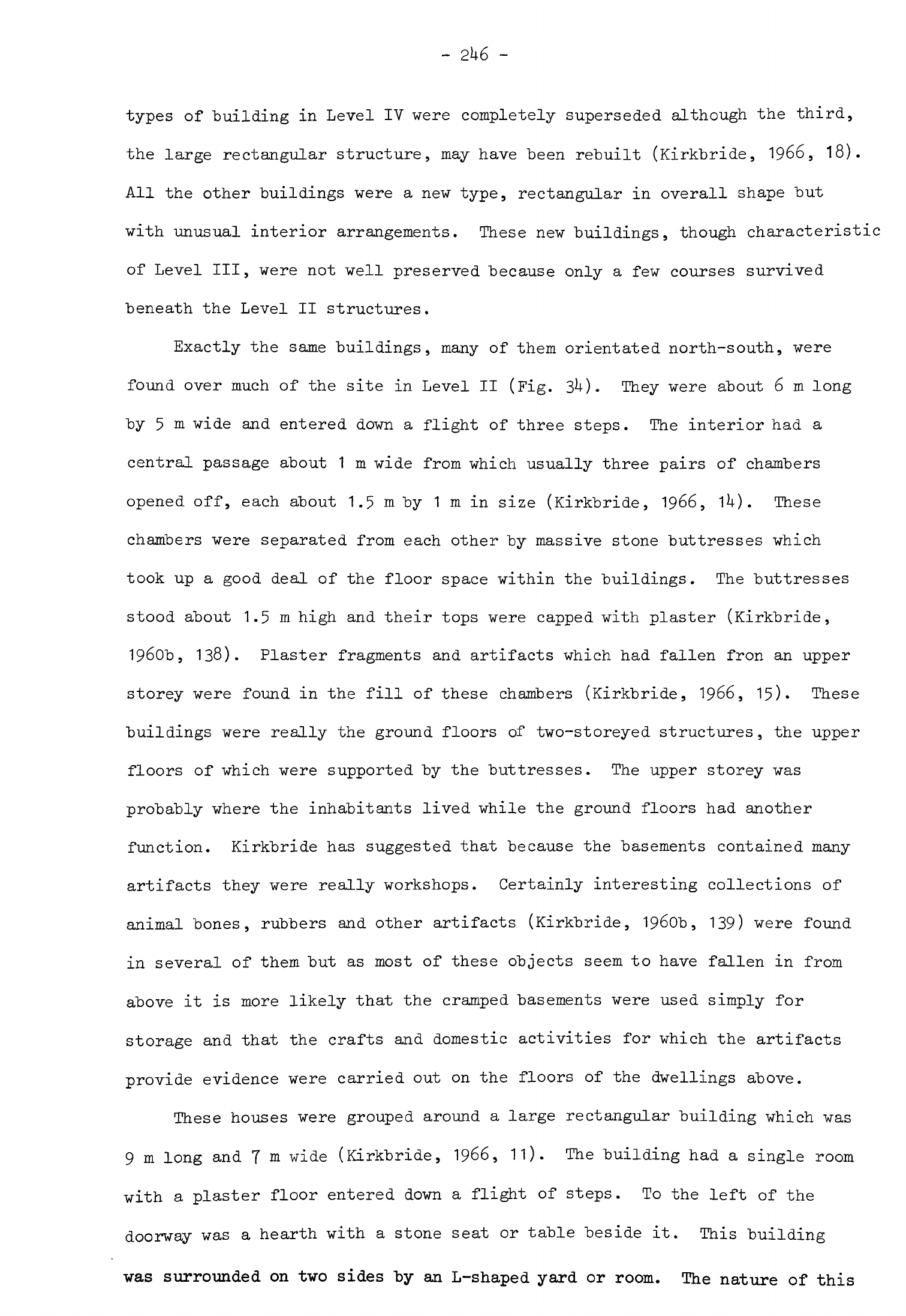
-
2U6
-
types of
building
in
Level
IV were completely
superseded
although
the third,
the
large
rectangular
structure,
may
have
been
rebuilt
(Kirkbride,
1966,
18).
All
the
other
buildings
were
a
new
type,
rectangular
in
overall
shape
but
with
unusual interior
arrangements.
These
new
buildings,
though
characteristic
of
Level
III,
were
not
well
preserved
because
only
a
few
courses
survived
beneath
the
Level
II
structures.
Exactly
the
same
buildings,
many
of
them
orientated
north-south,
were
found
over
much of
the
site
in
Level
II
(Fig.
3*0.
They
were
about
6
m
long
by
5
m
wide
and
entered
down
a
flight
of
three
steps.
The
interior
had
a
central
passage
about
1
m
wide
from
which usually
three
pairs
of
chambers
opened
off,
each
about
1.5
m
by
1
m
in
size
(Kirkbride,
1966,
1^).
These
chambers
were
separated
from
each
other
by
massive
stone
buttresses
which
took
up
a
good
deal
of
the
floor
space
within
the
buildings.
The
buttresses
stood
about
1.5m
high
and
their
tops
were
capped
with
plaster
(Kirkbride,
1960b,
138).
Plaster
fragments
and
artifacts
which
had
fallen
fron
an
upper
storey
were
found
in
the
fill of
these
chambers
(Kirkbride,
1966,
15)
These
buildings were
really
the
ground
floors
of
two-storeyed
structures,
the
upper
floors
of
which
were
supported
by
the
buttresses.
The
upper
storey
was
probably
where
the inhabitants
lived
while
the
ground
floors
had
another
function.
Kirkbride
has
suggested
that
because
the
basements
contained
many
artifacts
they were
really
workshops.
Certainly
interesting
collections
of
animal
bones,
rubbers
and
other
artifacts
(Kirkbride,
1960b,
139)
were
found
in
several
of
them
but
as
most
of
these objects
seem
to have
fallen
in
from
above
it
is
more
likely
that
the
cramped
basements
were
used
simply
for
storage
and
that
the
crafts
and
domestic
activities
for
which
the
artifacts
provide
evidence
were carried
out
on
the
floors
of
the
dwellings
above.
These
houses
were
grouped
around
a
large
rectangular
building which
was
9
m
long
and
7
m
wide
(Kirkbride,
1966,
11).
The
building
had
a
single
room
with
a
plaster
floor
entered
down
a
flight
of
steps.
To
the
left of
the
doorway
was
a
hearth
with
a
stone
seat
or
table
beside
it.
This
building
was
surrounded
on
two
sides
by
an
L-shaped
yard
or
room.
The
nature
of
this
10
m
Fig.
34
Be
idha-Level
n
buildings
(after
Kirkbride
and
Perrot)
complex
is
not
clear
"but
as
only
one
example
was
found
in
Level
II it
may
have been
a
communal
building.
Level
I
has
been
disturbed
by
later
human
activity
and
erosion
so
that
not
much
could
be
learned
about
its
layout.
One
building,
h
by
3
m
in
size,
had
a
single
room
with
a
plaster
floor.
This
may
have
been
a
house,
in
which
case
another
major
change
in
architecture
had
taken
place,
or
some
other
kind
of
building.
The
dead
at
Beidha
were
buried
beneath
the
floors
of
the
houses
,
in
abandoned
buildings
and
in
the
open
spaces
between
(Kirkbride,
1966,
23).
Most of
the
children
were
buried
complete but
the
skulls
of
several
of
the
adults
were
detached
and
buried
separately.
Some of
the
skeletons
were
also
in
disorder
following secondary
burial
but
most
were
intact.
The
teeth
of
the
adults
were
heavily worn
(Kirkbride,
1966,
16).
The
flint
tools
were
made
from
nodules
obtained
from
the
nearby
wadi
and
tabular
flint
from
Jebel
Shara
to
the
east
(Mortensen,
19TOa,
1^).
The
industry
was
predominantly
one
of
blade
tools
and
the
blades
were
struck
off
double-ended
cores.
Some of
the
flakes
came
from
discoid
cores
but prismatic
flake
cores
were
much
more numerous
and
many
of
these
had
been re-used
for
chopping.
Arrowheads
were
the
largest
single
class
of
tool,
forming
20
to
29$
of
the
retouched
artifacts
(Mortensen,
1970a,
^5).
Most
of
these
had
pointed
tangs
which
were
formed either
by
a
simple
narrowing
of
the
blade
or
with
a
notch
at
either
side
to
make
a
shoulder.
A
few
of
the
arrowheads
had
short
tangs
and
pairs
of
notches
like
those
from
Tell
Aswad
and
Tell
Ramad.
Most
of
the
tanged
arrowheads
were
retouched
around
the
tang,
under
the
tip
and
occasionally
along
part
of
the
blade.
Pressure-flaking
was
used
on
some
of
the
tangs
and
a
few
arrowheads
had
quite
extensive
squamous
retouch;
this
technique became
more
common
at
Beidha
later
in
the
occupation
sequence
(Mortensen,
1970a,
26)
as
on
the
Damascus
basin
sites.
Borers
were
another
particularly
common
tool
at
Beidha,
forming
a
higher
-
2U8
-
percentage
of
the
retouched
tools
here
(15-25$)
than
on
most
other
contemporary
excavated
sites.
They
were
made
on
"both
blades
and
flakes
and
could
be
divided
into
three
functional
categories.
The
first
was
short
points
on
flakes
and
blades
(Mortensen,
1970a,
fig.
20)
which
could
be
used
for
making
wide
holes
in
thin
materials.
The
second
was
very
thin
long
points,
a
numerous
class
particularly
suitable
for
drilling
holes
in
beads
(Mortensen,
1970a,
fig.
22
type
B7).
The
third
group
also
had
a
long
point
but
it
was
more
robust
and
frequently
blunt
(Mortensen,
1970a,
fig.
22
type
B9,
fig.
23
type
B10);
these
borers
were
probably
drills
or
reamers.
The
third
major
class
of
tools
(13-20$)
was
retouched
blades
and
flakes
described
as
knives
(Mortensen,
1970a,
32).
This
was
not
a
homogeneous
group
and
it
is
doubtful
if
all
these
tools
were
used
in
the
same
way.
Most of
them
had
only
a
little
edge
retouch.
Sickle
blades
and
flakes
were
not
very
numerous
but
present
in
much
the
same
proportions
(8-12$)
throughout
the
sequence.
There
were
a
few
sickle
flakes
in
Levels
VI
and V
(Mortensen,
1970a,
fig.
38)
but
blades
were
usually
preferred.
The
blades
had
nibbled
or
finely
denticulated
retouch
along
the
cutting
edge.
Burins
were
quite
rare
tools
at
Beidha.
They
were
all
dihedral
and
angle
types
(Mortensen,
1970a,
29),
the
usual varieties found
on
other
contemporary
sites.
Scrapers
were
also
quite
uncommon
(7~11.)«
Most
of
these
were
end-
scrapers
on
blades
and
flakes.
There
was
also
a
group
of
notched
flakes
and
blades
(Mortensen,
1970a,
36ff).
Two
interesting
groups
of
tools
were
identified
at
Beidha
which
have
so
far
been
recognised
at
very
few
other
sites.
One was
interpreted
as
firestones
or
strike-a-lights
(Mortensen,
1970a,
38ff).
These
were
thick
blades
and
flakes
with
signs
of
heavy
battering
at
one
end
or
along
part
of
the
side
of
the
piece.
Mortensen
has
identified
similar
tools
at
Labweh.
The
other
group
was
retouchers
thought
to
have
been used
in
pressure-flaking
(Mortensen,
1970a,
These
were
blades
and
crested
"blades
with
signs
of
heavy
wear
at
the
proximal
end.
Large
core
tools
were
rare
at
Beidha
as
on
the
Euphrates
sites
"but
in
contrast
with
those
in
the
West
Syrian
Group.
The
axes
and
adzes
were
usually
trapezoidal
or
oval
in
shape
with
a
flaked
or
polished
cutting
edge
(Mortensen,
1970a,
k2).
A
few
had
been sharpened
with
a
tranchet
blow.
Some
core
tools
which
had
a
narrow
cutting
edge
have
been
interpreted
as
chisels
(Mortensen,
1970a,
Ul).
The
other
types
of
core
tools
were
picks
and
spherical
hammer-
stones
(Mortensen,
1970a,
k3)
•
The
hammerstones were
flint
spheroids
covered
with heavy
battering
marks.
These
may
indeed
have
been
used
as
hammers
but
could
also
have
been
used
as
weights,
perhaps
for
bolas.
This
class
of
artifacts
was
abundant
at
Abu
Hureyra
and
examples
have
been
found
on
other
Neolithic
2
sites
although
they
were
not
common
everywhere.
Only
three
pieces
of
obsidian
were
found
at
Beidha.
When
analysed
the
two
pieces
in
Levels
IV
and
V
were
found
to
be from
Ciftlik
and
the
one
in
Level
II
to
be
from
one
of
the
he
sources
in
eastern
Anatolia
(Renfrew
et
al.
,
1968, 325).
The
inventory
of
other
artifacts
from
Beidha
was
rich,
the
greatest
variety
of
types
coming
from
the
upper
levels.
Stone
grinding
tools
were
uniquitous
and
rubbers
and
querns
especially
numerous
(Kirkbride,
1966,
32ff).
Some
of
the
querns
were
open-ended
and
the
remainder
had
a
depression
worn
in
the
centre.
Most
of
the
rubbers
were
oval
with
a
plano-convex
section
and
some
had
been used
for
grinding
ochre.
A
few
pestles
and
mortars
were
found
but
stone
bowls
were
quite
rare
at
Beidha.
These
heavy
stone
tools
were
made
of
limestone,
basalt
and
granite
all
of
which
were
available
in
the
vicinity
of
the
site.
One
or
two
small
polished
axes
were
found
(Kirkbride,
1966,
35)
but
almost
all the
other
axes
and
adzes
were larger
tools
about
10
cm
long
made
of
basalt.
These
were
pecked
out
and
the
cutting
edges
ground
down
to
produce
a
straight
or
rounded
edge.
-
250
-
Among
the
other
stone tools
were
a
number
of
weights
which
had
a
large
hole
"bored
at
one
end.
An
identical
example
was
discovered
at
Tell
Ramad
(de
Contenson,
1969b,
33).
Their
function
is
uncertain
although
their
size
tells
us
something
about
their
likely
use.
They
were
too small to
have
been
used
as
roof
weights,
for
example,
but
about the
right
size
for
loom
weights
in
an
upright
loom
which
is
one
possible
explanation
of
their
purpose.
The
remaining
stone tools
included
several
types
hardly
known
elsewhere.
There
were
a
number
of
thin
rectangular
pieces
of
sandstone
with
a
hole
for
suspension
bored
at
one
end.
These
were
polished
on
both
sides
and
one
had
been
scored
repeatedly
with
a
flint
tool
as
it it
has
been
used
as
a
cutting
surface.
Another
unusual
artifact
found
in
small
numbers
was
a
stone
slab
with
two
rows
of
small
holes
in
the
surface
and
other
markings
which
may
have
been used
as a
gaming
board
or
simply
as
a
base
for
a
bow
drill.
Bone
tools
were
numerous
throughout
the
Beidha
sequence
from
Level
VT
up.
The
usual
kinds
were
borers
of
varying
sizes
(Kirkbride,
1966,
30)
but
spatulae
were
als.o
quite
common.
A
few
of
the
latter were
quite
delicate
as
were
several other
small
bone
pins
and
spoons.
Beads
and
other
decorative
objects
were
also
common
at
Beidha.
Shell
was
a
particularly
favoured
raw
material
(Kirkbride,
1966,
28)
and
was
imported
from
both
the
Mediterranean
and
Red
Sea.
Cowrie,
mother-of-pearl,
dentalium,
cockle
and
other
species
were
all
used
for this
purpose.
The
bone
and
stone
beads
were
usually
cylindrical
in
shape
but
some
flat
amulets
were
also
made.
Clay
figurines
were
not
very
common
at
the
site
but
both
humans
and
animals
were
modelled.
Several
fragments
of
ibex
were
particularly
naturalis-
tic (Kirkbride,
1966,
26).
One
or
two
small
clay
vessels
were
also
found.
Some
of
these
objects
were
baked
but
whether
intentionally
or
not
was unclear.
Good
evidence
was
found
for
the use of
wooden
containers
and
baskets
at
Beidha
(Kirkbride,
1967,
10).
Traces
of
several
wooden
boxes
were
noticed
in
the
sandy
occupation
levels,
one
of
which
had
contained
11^
flint
arrow-
heads
and
points.
Some
of
the
baskets
had
been
lined
with plaster
or
bitumen
-
251
-
either
to
make
them
watertight
or
more resistant
to
penetration
by
rodents.
The
raw
materials
used
at
Beidha
were
quite
as
varied
as
on
contemporary
sites
elsewhere.
Pumice
from
the
Mediterranean
was
used
as
an
abrasive
(Kirkbride,
1966,
51),
haematite
for
polishing,
ochres
and
malachite
as
colouring
matter.
Few
of
these
materials, however,
were
imported
from
far
away
because
they
could
be
obtained
from
the
vicinity
of
the
site.
The
exceptions
were
the
marine
products,
obsidian,
and
a
little
steatite.
Beidha,
therefore,
enjoyed
less
extensive
regular
contacts
through exchange
than
other
sites
further
north.
The
length
of
time
that
Levels
VI
and
I
were
occupied
has
been
determined
fairly
satisfactorily
from
a
series
of
lk
carbon
1^
dates.
The
dates
are
as
follows:
Level
VI
Level
V
Level
IV
Level
II
6990
±
160
B.C.
K-1086
6900
±
150
B.C.
K-iino
6820
±
150
B.C.
K-llni
6770
±
150
B.C.
K-1^12
6765
±
100
B.C.
P-1378
6760
±
130
B.C.
K-1082
6596
±
100
B.C.
P-1379
6690
±
160
B.C.
K-1083
7178
±
103
B.C.
P-1380
68^0
±
200
B.C.
BM-111
6815
±
102
B.C.
P-1381
6780
±
160
B.C.
K-1081+
69^2
±
115
B.C.
P-1382
6600
±
160
B.C.
K-1085
(Radiocarbon
10,
1968,
323)
(Mortensen,
1970a,
13)
(Mortensen,
1970a,
13)
(Mortensen,
1970a,
13)
(Radiocarbon
11,
1969,
152)
(Radiocarbon
10,
1968,
32*0
(Radiocarbon
11,
1969,
152)
(Radiocarbon
10,
1968,
32U)
(Radiocarbon
11,
1969,
152)
(Radiocarbon
10,
1968,
k)
(Radiocarbon
11,
1969,
152)
(Radiocarbon
10,
1968,
32U)
(Radiocarbon
11,
1969,
152)
(Radiocarbon
10,
1968,
These
dates
cluster
close
together
over
four
centuries
between
6600
B.C.
and
7000
B.C.
The
earliest
date,
P-1380
from
Level
IV,
takes
the
sequence
a
little
further
back
but
one
might
still
estimate
that
Level
VI
was
first
occupied
about
7100
or
7000
B.C.
and
the
site
finally
abandoned
about
6500
B.C.
If
one
attempts
to
date
each
level
in
the
archaeological
sequence
from
these
determinations
considerable
difficulties
arise.
This
is
because
the
dates
-
252
-
from
individual
levels,
particularly
VI
and
IV,
are
spread
over
several
centuries.
The
reason
for
this
is
in
part
the
nature
of
the
material
analysed
which
ranged
from
carbonized pistachio
nuts
to
oak
and
juniper
charcoal
(Radiocarbon
10,
1968,
323ff).
The
nuts
might
be
expected
to
have
been
buried
about
the
year
they
were
harvested
but
the
timber
could
have
already
been
old
when
it
was
burned.
This
makes
it
impossible
to
date
the
occupation
sequence
in
more
detail
even
though
so
many
determinations
have
been
made
unless
much
more
information
about
the
nature
of
the
carbon samples
and
their
stratigraphic
location
becomes
available.
One
more
point
should
be
remembered
and
that
is
that
the
Neolithic
occupation
at
Beidha
probably
began
well
back
in
Neolithic
1
so
that
the
settlement
may
already
have
been
several
centuries
old
when
the
first
Level
VI
buildings
were
constructed.
We must
now
consider
the
relationship
between
the
occupation
at
Beidha
in
Levels
VI
to
I
and
other
sites
in
the
Levant.
From
Level
V
on
the
inhabi-
tants
began
to
construct
rectilinear
buildings
with
plaster
floors
and
this
development
links
Beidha
with Neolithic
2
sites
further
north
such
as
Jericho,
Tell
Ramad
and
Abu
Hureyra.
Burial
customs
at
Beidha
also
have
much
in
common
with
these other
sites. The
flint
industry,
based
as
it
is
on
large
blades
usually
struck
from
double-ended
cores,
is
in
the
Levantine
Neolithic
2
tradition.
The
range
of
tools
and
the
arrowheads
in
particular
can
all
be
matched
on
Neolithic
2
sites
further
north.
Most
tools
had
very
little
retouch,
a
link
between
Beidha
and
sites
like
Aswad
II
which
like
Beidha
is
dated
early
in
the
7th
millennium.
The
richness
of
the
remainder
of
the artifacts
is
another
hallmark
of
Neolithic
2
sites
when
compared
with
those
of
Neolithic
1.
As
elsewhere
the
bone
tools
are
particularly
abundant.
The
typology
of
the
flints,
the
evolution
of
the
architecture
and
the
14
C
dates
all
indicate
that
Beidha
VI
to
I
was
inhabited
in
the
first
half
of
the
7th
millennium
early
in
Neolithic
2
The
general
relationship
between
Beidha
and
other
Neolithic
2
sites
in
the
Damascus
basin
and
the
Euphrates
region
is
clear
but
there
are
certain
-
253
-
aspects
of
the
remains
at
Beidha which
are
unique
to
the
site.
The
most
obvious
example
of
this
is
the
development
of
the
architecture. The
circular
houses
of
Level
VI,
while
"bearing
a
general
resemblance
to
the
circular
stone
huts
of
Neolithic
1
Nahal
Oren
and the
mud-brick
houses
of
PPNA
Jericho,
are
built
differently
with
a
ring
of
posts
set
in
the
walls.
Some
of
the
simple
rectilinear
buildings
are
like
those
at
Tell
Ramad,
Labweh
and
elsewhere
but
the
two-storeyed
houses
with
chambered basements
are
unique
to
Beidha.
The
changes
in
building
types
took
place
rapidly
yet
there
is
no
suggestion
that
the
sequence
of
occupation
at
the
site
was
interrupted.
On
the
contrary
the
preliminary
study
of
the
flint
industry
shows
only
gradual
changes
through
time
as
though
the
same
group
of
people
continued
to
inhabit
the
site
throughout
the
occupation
sequence
(Mortensen,
1970a,
hj).
The
architectural sequence
at
Beidha
thus
appears
to
have
been
a
local
phenomenon
even
though
in
the
most
general
sense
it
mirrors
a
trend
apparent
throughout
the
Levant
in
the
8th
and
7th
millennia.
Kirkbride
carried
out
a
surface
survey
around
Beidha
and
found
three
more
Neolithic
2
sites
in
the
area.
Two,
Shaqar
et
M'siad
and
Adh
Dhaman,
were
in
the
hills
near
Beidha.
Shaqaret
M'siad
lay
in
a
valley
a
little
to
the
north
(Kirkbride,
1966,
5^)-
The
site
was
about
1.8
ha
in
area
and
consisted
of
the
remains
of
rectilinear
stone
buildings
some
of
which
had
plaster
floors.
The
finds
included
querns
and
stone
grinders
as
well
as
an
abundant
flint
industry
with
tanged
and
notched
arrowheads.
Adh
Dhaman
lay
south
of
Beidha
near
a
spring
(Kirkbride,
1966,
55ff)
The
site
was
perhaps
1
ha
in
area
with
the
remains
of
rectilinear
stone-walled
structures
on
the
surface,
some
of
which
had
plaster
floors.
Among
the
finds
were
rubbers,
querns
and
tanged
and
leaf-shaped
arrowheads.
The
third
site,
Bir
et-Taiyiba,
lay
almost
due
west
of
Beidha
near
a
spring
on
the
floor of
the
Wadi
Arabah.
There
were
traces
of
occupation
deposit
here
but
no
structures
and among
the
finds
were
tanged
arrowheads.
These
three
sites
appear
to
belong
to
Neolithic
2
and
should be
7th
millennium
in
date.
Their
precise
cultural
affinities
are
unknown
"but
Shaqaret
M'siad
and
Adh
Dhaman
seem
to
have
much
in
common
with
Beidha
and
Bir
et-Taiyiba
was
probably
also
occupied
in
the
7th
millennium.
Another
Neolithic
2
site
in
this
region
is
Ain
Abu
Nakheileh
which
lies
in
the
Wadi
Rum
at
the
foot
of
Jebel
Rum
near
the
spring
which
gives
the
site
its
name
(Kirkbride,
1960c,
231).
Much
of
the
plan
of
the
site
could
be
discerned
from
the
surface.
It
was
composed
of
stone-walled
multi-roomed
buildings
of
both
circular
and
rectilinear
plan;
the
floors
of
the
circular
ones
at
least
lay
below
ground
level.
The
chipped
stone
industry
was
composed
of
blade
tools
of
which
pressure-flaked
leaf-shaped
arrowheads
were
the
dominant
type.
Hollow
querns,
grinders,
pestles
and
other
ground
stone
tools
were
also
found.
The
typology
of
the
arrowheads
would
suggest
that
the
site
was
occupied
late
in
Neolithic
2
while
the
plans
of
the
buildings
can
be
paralleled
at
Beidha
and
Wadi
Dhobai
B.
The
German
expedition
to
Kilwa
in
the
Jebel
Tubaiq
discovered
at
least
one
surface
Neolithic
station,
site
19«
The
inventory
consisted
of
numerous
flake
tools
as
well
as
blades
and
blade
tools.
The
blades
had
been
struck
off
double-ended
and
prismatic
cores
(Rhotert,
1938,
91,
92)
with
crested
blades
as
a
by-product
(Rhotert,
1938,
98,
99).
These
can
be
exactly
paralleled
at
Beidha
as
well
as
on
sites
further
north.
Among
the
blade
tools
were
angle
and
dihedral
burins
(Rhotert,
1938,
96,
97),
abruptly
retouched
reamers
(Rhotert,
1938,
10U:1)
and
tanged
arrowheads
(Rhotert,
1938,
11U).
The
arrow
heads
had
well-defined
shoulders
and
one
or
two
were
winged
but
none
was
notched.
Several
had
extensive
squamous
retouch.
There were
also
a
number
of
small
oval
points
that
may
have
been
arrowheads.
The
flake
tools
included
a
number
of
scrapers
(Rhotert,
1938,
91,
105,
118,
119),
some
of
which
were
on
tabular
flint.
There
was
also
a
series
of
bifacial
ovates
and
other
flake
tools
which
may
have
been
scrapers
(Rhotert,
1938,
106)
together
with
triangular,
trapezoidal
and
oval
axes
and
picks
(Rhotert,
1938,
110,
112).
A
number
of
other
flake
tools
were
found
which
had
been
extensively
retouched
with
pressure-flaking
(Rhotert,
1938,
117).

-
255
-
This
assemblage
appears
to
"be
homogeneous
and
good
parallels
for
the
"blade
tools
and
some
of
the
flake
tools
can
be
found
at
Beidha
and
other
excavated
Neolithic
2
sites.
The
general
shape
of
the
Kilwa
arrowheads
conforms
very
well
to
those
at
Beidha
but
they
are
more
extensively
retouched
than
most
Beidha
examples.
The
numerous
bifacial
tools,
also
extensively
retouched,
are
not
so
readily
matched
at
Beidha
or
any
other
excavated
site
although
they
are
similar
to
surface
finds
from
Kharaneh
IV.
The
use
of
so
much
pressure-flaking
suggests
that
site
19
may
postdate
Beidha
and
so
have
been
occupied
relatively
late
in
the
7th
millennium
but
many
tools
in
the
assemblage
are
clearly
in
the
same
tradition
as
those
at
Beidha
and
Wadi
Dhobai
B.
Fewer
Neolithic
2
sites
have
been
found
in
southern than
in
northern
TransJordan
because
the
area
is
relatively
remote and
much of
it
difficult
of
access
but
since
sites
with
quite
rich
remains
have
been
found
as
far
to
the
south-east
as
Kilwa
it
is
probable
that
the
whole
area
was
occupied.
It
is
also
likely
that
occupation
extended
into
northern
Arabia
in
regions
not
yet
examined
for
Neolithic
remains.
Although
so
many
sites
are
known
in
TransJordan
only
Beidha
has
a
long
sequence
of
occupation,
well-preserved
buildings
and
a
comprehensive
artifact
inventory.
All
the
others
lack
the
full
cultural
assemblage
and
without
this
one
cannot
assign
them
with
certainty
to
Neolithic
2
regional
groups.
It
is
fairly
clear
that
the
flint
industries
from
most
of
the
stations
have much
in
common
with
Palestinian
Neolithic
2
sites
even
if
in
certain
details
such
as
the
rarity
of
winged
or
notched
tanged
arrowheads
there
are
differences.
Much of
the
material
at
Beidha
can
also
be
paralleled
on
Palestinian
sites
yet,
as
we have
seen,
there
is
much
individuality
in
the
buildings and
certain
of
the
artifacts
from
the
settlement.
If
we
knew
more
about
the
remains
from
Neolithic
2
sites
other
than
Beidha
in
TransJordan
we
might
be
able
to
define
another
regional
group
but
as
we
lack
such
detailed
information
it
is
best
for the
moment
to
note
such
differences
as
there
are
between
the
sites
in

-
256
-
Transjordan
and
Palestine and
to
place
all
the
TransJordanian
sites
in
a
sub-group
closely
linked
with Neolithic
2
sites
in
Palestine.
Principal
cultural
characteristics
of
Neolithic
2
settlements
I
have
now reviewed
most
of
the
known
Neolithic
2
sites
in
the
Levant
and
described
their
material
remains.
Before
going
on
to
discuss
the
economy
and
society
of
their
inhabitants
it
will
be
useful
to
consider
some
of
their
general cultural
characteristics
in
order
to
understand
more
clearly
the
differences
between
Neolithic
2
and
the
preceding
stages.
One of
the
principal
features
which
distinguished
Neolithic
2
settlements
from
those
of
Neolithic
1
was the
shape
and
construction
of
the
dwellings.
Almost
everywhere
these
were
rectilinear
in
shape
and
built
of
stone
or
mud-
brick
or
the
two combined.
Mud-brick
was
now
used
commonly
as
a
building
material
on
sites
in
Syria
and
quite
often
elsewhere.
The
plans
of
these
buildings
varied
from
place
to
place
but
the
new
style
was
adopted
throughout
the
Levant
early
in
Neolithic
2.
It
has
remained
the
usual
mode
of
domestic
building
in
the
villages
of
the
Levant
down
to
the
present
day.
The
rooms
of
these
buildings
often
had
floors
made
of
lime
plaster
coloured
with
red
ochre
or
a
black
pigment.
Occasionally
designs
were
painted
on
the
floors
and
the
plaster
or
whitewash
of
the
walls.
This
is
the
earliest
evidence
we
have
for
the
decoration
of
the
interiors
of
buildings
in
the
Levant,
itself
part
of
the
elaboration
of
culture
that
took
place
as
a
sedentary
way
of
life
became
established.
A
second
important
constituent of
Neolithic
2
material
remains
was the
chipped
stone
industry.
Most
of
the
tools
were
now
made
on
large
blades
and
the
tool
types
themselves
were
clearly
separated
from
each
other
in
form
and
probably
function
as
well.
Flake
scrapers
and
a
few
other
distinct
types
of
flake
tools
were
quite
common
on
many
sites
but rarely
a
major
component
of
the
industry.
This
stone
industry
differed
markedly
from
that
of
the
Mesolithic
and
Neolithic
1
S
having
more
in
common
with
the
Levantine
Aurignacian,
-
257
-
a
coincidence
at
present
difficult
to
understand
"because
we
know
so
little
about
the
uses
to
which
Aurignacian
flint tools
were
put.
Neolithic
2
"blade
tools
were
heavier
and
more
robust
that
in
Neolithic
1
and
some
of
the
tool
types
were
quite
different,
technological
changes that
should
reflect
modified
activities
and
new
needs.
These tools
would
have
been
more
suitable
for
repeated
use
in
specific
tasks
than
the
much
slighter
equipment
of
Neolithic
1.
Lighter
tools
composed
of
microliths
were
not
now
made
at
all.
Most
Neolithic
2
sickle
blades
were
made
on
complete
blades
rather
than
segments.
It
is
possible
to
determine
how
they were
hafted
from
the
lustre
found
on
the
cutting
edge.
Many
still
seem
to
have
been
hafted
with
other
sickle
blades
to
make composite
sickles
with
a
straight
cutting
edge
but
some
were
apparently
hafted
at
the
butt
end
only
and
used
as
knives.
Segmented
sickle
blades were
made
on
a
few
sites
and
hafted
to
form
composite
tools
with
a
curved
or
even
jagged
edge
as
at
Tell
Aswad
(Balikh)
(Cauvin,
1973,
fig.
3).
Sickles
armed
in
this
way
had
a
much
tougher
cutting
edge
than
anything
made
in
Neolithic
1.
I
think
it
is
probable
that
these
tools
were
used
for
harvesting
cultivated
cereals
on
sites
where
they
have
been
found
in
large
numbers.
Cereals,
as
we
shall
see,
were
a
major
constituent
of the
diet
on
many
sites
in
Neolithic
2
and
so
new
types
of
sickle
were
developed
to
cut
the
larger
quantities
that
now
had
to
be
harvested
every
year.
At
sites
like
Abu
Hureyra
where
there
is
no
clear
association
of the
few
robust
sickle
blades
that
were
found
with
the
ample
evidence
of
cereal
agriculture
it
is
more
probable
that
the
sickle
blades
were
used
for
other
regular
tasks
such
as
gathering
reeds
for
roofing
or to
make
baskets.
The
different
types
of
Neolithic
2
arrowheads
were
almost
all
variations
of
tanged
blades.
They
were
relatively heavy
and
strong
with
considerable
penetrating
power.
These
arrowheads
were
probably
adopted
in
preference
to
Khiamian
points
or
composite
arrowheads
because
changes
were
taking
place
in
hunting
practices.
The
lighter
arrowheads
of
Neolithic
1
would
have
been
more
suitable
for
killing
small
game
and
birds.
It
may
be
that
heavier
arrowheads
were
now
required
because
less
small
game
was
being
hunted
and
more
larger
-
258
-
ruminants.
The
effectiveness
of
small
arrowheads
would
have
"been
much
increased
with
the
use
of
poisons;
it
may
be
that
poisons
were
not
now
used
and
that
heavier
arrowheads
which
would
have
wounded
animals
more
effectively
were
substituted
instead.
The
large
tanged
arrowhead
found
imbedded
in
the
chest
of
a
human skeleton
at
Abu
Hureyra
provides
vivid
evidence of
violence
in
Neolithic
2
society.
It
may
be
that
heavier
arms
were
now
preferred
as
more
effective
weapons
in
fighting
between
Neolithic
2
communities.
The
other
common
Neolithic
2
tool
types such
as
end-scrapers and
burins
were
also
larger
and
more
robust.
This
may
be
an
indication
that
they
were
now
used
for
particular
crafts
which
were
practised
more
regularly.
Flaked
axes
and
adzes
were
made much more
frequently
in
Neolithic
2
than
before.
There
were
many
varieties
of
these,
some
made
of
flint
and
others
of
tougher
exotic
stones.
Many
were
simply flaked
but
others
had
polished
edges
to
increase
their
cutting
effectiveness.
These
tools
were
probably
used
to
trim
timber
and
fashion
it
into
shapes
suitable
for
building
or
for
boxes,
platters
and
tools.
This
evidence
for
an
increase
in
woodworking
is
another
indication
of
the
flowering
of
crafts
in
Neolithic
2.
Flaked
and
polished
axes
of
all
kinds
were
rare
on
the
Middle
Euphrates
sites
but
common
at
Tell
Ramad,
Tall
Labweh
and
other
sites
in
the
West
Syrian
group.
They
were
also
numerous
at
Beisamun,
Munhatta,
Abu
Gosh,
on
surface
sites
in
Judea
and
other
sites
in
the
Palestinian
group
as
well
as
at
Beidha.
In
the
7th
millennium
all
these
sites
lay
within
the
Mediterranean
forest
zone
whereas
the
Euphrates
sites
did not
so
there
is
a
definite
correlation
here
between
a
specific
type
of
tool and
an
environmental
area.
Timber
would
have
been
more
readily
available
for
human
use
in
the
Mediterranean
forest
zone
than
elsewhere
but
the
presence
of
so
many
axes
on
these
sites
in
Neolithic
2
may
be
an
indication
that
more
forest
clearance
was
taking
place
than
before.
Rubbers,
querns
and
other
ground
stone
tools
were
more
abundant
on
Neolithic
2
settlement
sites
than
in
Neolithic
1.
This
increase
in
the
amount
-
259
-
of
heavy
equipment
used
is
another
concomitant
of
a
more
sedentary
way
of
life.
The
great
increase
in
the
use
of
querns
and
rubbers
also
correlates
with
the
widespread
adoption
of
cereal
agriculture
in
Neolithic
2
so
it
is
probable
that
most of
these tools
were
used
for
grinding
cereals
for
food.
Neolithic
2
burial
practices
were
quite
similar
throughout
the
Levant.
Most
skeletons
were
buried
in
a
crouched
position
with
few,
if
any,
grave
goods.
Skeletons
were
frequently deposited
incomplete
in
collective
graves
after
the
flesh
had
decayed
in
a
primary
burial
or
through
exposure.
Skulls
were
often
detached
from
the
bodies
to
which
they
belonged
and
buried
apart
sometimes
after
receiving
special
treatment.
These
customs
began
in
Neolithic
1
and
were adopted
by
the
inhabitants
of
almost
all
settlements
in
Neolithic
2
although
there
were
some
variations
in
the
exact
form
of
burial
from
site
to
site.
In
Neolithic
2
the
same
general
cultural
characteristics,
that
is
burial
practices,
style
of
dwellings
and
classes
of
artifacts
were
to
be
found
on
sites
throughout
the
Levant.
This
broad
cultural
uniformity
is
an
important
feature
of
Neolithic
2
as
it
implies
that
the
communities
which
shared
these
traits
were
in
close contact
with
each
other.
From
the
large
quantity of
artifacts
and
other
material
collected
and
excavated
from
Neolithic
2
sites
we
can
discern three
regional
groupings
of
sites,
one
of
which
had
two
sub-
groups,
defined
by
local
variations
in
artifacts
and
other
remains.
These
Neolithic
2
regional
groups,
Middle
Euphrates,
West
Syrian
and
Palestinian
correspond
to
those
established
for
Neolithic
1:
Middle
Euphrates,
Damascus
basin
and
Palestine,
while
one
of
the
Neolithic
2
sub-groups,
the
Negev
and
Sinai,
is
in
the
same
area
as
the
Harifian
group
of
Neolithic
1.
We
have
already
seen
that
Neolithic
2
evolved from
Neolithic
1
in
the
three
main
regions
so the
same
regional
pattern
is
a
feature
of
both
Neolithic
1
and
Neolithic
2.
The
duration
of
Neolithic
2
has
been
established
fairly
certainly
by
the
llf
C
determinations
made
in
recent
years.
In
the
south
Level
VI
at
Beidha
-
260
-
"began
about
7100
or
7000 B.C.
Jericho
was
resettled
about
7000
B.C.
or
a
little
before
at
the
beginning
of
the
PPNB
which should
be
early
in
Neo-
lithic
2.
In
the
Damascus
basin
the
transition
from
phase
I
to
phase
II
at
Tell
Aswad
took
place
about
6900
B.C.
or
a
little
later.
From
these
dates
we
can
see
that
Neolithic
2
began
throughout
the
Levant
within
only
a
century
or
two
of
7000 B.C.
The
new
cultural
configuration
thus
crystallized
very
rapidly
all
over
the
region.
The
end
of
Neolithic
2
is
signified
by
the
beginning
of
potting
on
sites
in
Syria
and
Lebanon
and
certain
other
cultural
changes. This
happened
at
Buqras
in
level
III
which
began
about
6000
B.C.
or
a
little
after.
The
same
change
at
Tell
Ramad
also
took
place
in
the
transition
from
Level
II
to III
at
the
same
time
as
at
Buqras.
The
two
best
dated
sites
in
Palestine
and
TransJordan,
Jericho
and
Beidha,
were
both
abandoned
in
the
mid
6th
millennium
well
before
the
end
of
Neolithic
2.
On
consideration
of
typological
comparisons
it
seems
that
other
Neolithic
.2
settlements
like
Munhatta
continued
to
be
occupied
as
late
as
those
further
north
and
that
the
period
ended
about
6000
B.C.
in
Palestine
as
it
did
elsewhere.
In
the
central
and
northern
Levant
Neolithic
2
ended
as
swiftly
as
it
had
begun
and
was
rapidly
followed
by
a
new
cultural
configuration
which, however,
was
derived
from
Neolithic
2
and
with
which
its
material
remains
had
much
in
common.
Distribution
of
sites
Neolithic
2
sites
have
been
found
in
almost
all
geographic
zones
throughout
the
Levant.
There
are
sites
in
the
Sinai
valleys,
Jebel
Meghara
in
northern
Sinai, the
High
Negev
(Har
Harif
G2),
the
Negev
valleys
(Nahal
Divshon)
and
the
lowlands of
the
northern
Negev
(Halutza
dunes,
Nizzana).
Others
have
been
found
in
the
dunes
along
the
present
coast
of
Palestine
and
Lebanon
(Jaffa,
Ashdod,
Tell
aux
Scies);
these
sites
were
still
some
distance
inland
from
the
sea
in
Neolithic
2.
The
uplands of
Mt.
Carmel
(Nahal
Oren,
Iraq
el
Barud)
and
the
Judean
hills
(Abu
Gosh,
Tahuneh)
were
densely
occupied
and
at
least
one
site
is
known
on
the
lower
slopes
of
the
Lebanon
mountains
(Dik
el
Mehdi
II).
-
261
-
There
are
several
sites
along
the
whole
length
of
the
Jordan
valley
(Jericho,
Munhatta,
Besiamun)
and
also
one
in
the
Beka'a
(Saaideh).
Many
have
now
"been
found
on the
TransJordan
plateau,
in
the
extreme
south-east
at
Kilwa,
in
southern Transjordan
(Beidha,
Ain
Abu
Nakheileh),
in
Gilead
(Jerash)
and
far
out
on
the
eastern
desert
(Wadi
Dhobai,
Azraq.).
The
Hauran and
the
Damascus
"basin
(Tell
Ramad,
Tell
Aswad)
were occupied
as
well
as
the
Anti-Lebanon
(Nacharini,
Mugharet
el
Abde).
In
the
north
there
is
a
site
at
Ras
Shaxnra
on
the
Syrian
coast,
further
inland
from
the
sea
than
it
is
now,
and
in
the
Jebel
Alawiye
(Slenfe).
Many
sites
have
been
discovered
on
the
Syrian
plateau
around
Palmyra
and
in
the
passes
leading
to
the
middle
Euphrates
(El
Kum).
Several
more
are
now
known
in
the
Euphrates
valley
(Abu
Hureyra,
Buqras)
and
others
in
the
Jezireh
on
the
Balikh
(Tell
Aswad)
and
as
far
to
the
north-east
as
the
Jebel
Abdul Aziz
and
the
Khabur
(Tell
Fakhariyah).
All
regions
were
now
occupied
except
the
highest
mountains
of
Lebanon,
an
area
which
was
avoided
now
as
it
had
been
in
the
Mesolithic
and
Neolithic
1.
There
were
also
still
relatively
few
sites
at
lower
altitudes
in
the
Lebanon,
possibly
because
the
country
was
rugged
and
still
densely
forested
so
unat-
tractive
for
settlement.
The
Judean
hills
were
much more
intensively
occupied
than
they
had
been
in
Neolithic
1.
This
was
an
area
of
Mediterranean
forest
which
had
already
begun
to
thin
out
because
of
climatic
changes.
Sites
in
this
area
have
yielded
many
stone
axes,
an
indication
that
man
was
accelerating
the
natural
decline
of
woodland
through
forest
clearance,
so
helping
to make
the
area
more
attractive
for
settlement.
Settlements
in
Neolithic
2
were
much
more
widespread
than
in
Neolithic
1.
They
extended
beyond
the
open
forest
zone
into
the
steppe
on
the
Syrian
plateau,
in
Transjordan
and
Sinai
and
in
the
extreme
south-east
of
the
Levant
into
the
desert.
These
areas
had
not
attracted
settlement
in
Neolithic
1
and
only
rarely
in
the
Mesolithic.
The
environmental
changes
of
the
7th
millennium
brought
about
an
expansion
of
the
steppe
at
the
expense of
the
forest
zones.
It
might
be
thought
that
this
trend
would
inhibit
settlement
in
these semi-
-
262
-
arid
regions
yet
the
reverse
happened. The
explanation
for
this
paradox
will
become
clear
when
we
consider
the
changes
that
were
taking
place
in
the
population
of
the
Levant
and
its
economy.
Sites
in
Neolithic
2
were
more
varied
in
type
than
in
Neolithic
1.
Some
were
simply
stations
occupied
"briefly
by
small
groups
engaged
perhaps
in
hunting
or
foraging.
The
second
type
of
site
was
a
camp
with
remains
of
huts
and
a
fuller
artifact
inventory
testifying
to
longer
occupation.
Sites
such
as
these
were
the
Wadi
Dhobai
camps,
Ain
Abu
Nakheileh,
Nahal
Divshon,
Tell
el
Far'ah
and
Sheikh
All.
They
were
occupied
by
larger
groups
which
were
perhaps
semi-sedentary
or
sedentary.
A
third
type
of
site can
be
identified
which
had
a
more
specialised
function.
These
were
factory
sites
for the
preparation
of
flint artifacts.
Duara,
Abu
Suwan
and
Etam
are
sites
of
this
kind;
they
are
all
large
for
the
Neolithic
2
knappers
exploited
the
raw
material
over
a
wide
area
and
returned
to
these
sites
time
and
again.
The
fourth
type
of
site
was
a
settlement
composed of
a
nunber
of
dwellings
which
was
probably occupied
all
the
year
round.
Beidha,
Abu
Gosh,
Munhatta,
Tell
Ramad
and
Buqras
were
all
sites
of
this
kind.
These
were
the
typical
villages
of
Neolithic
2
situated
in
the
Mediterranean
forest
and
open
forest
zones
for the
most
part.
The
exceptions
such
as
Buqras
which
was
in
the
steppe
zone
were
in
particularly
favourable
local
environments
like
the
Euphrates
valley.
One
more
type
of
site
may
be
defined
which
is
much
larger
than
the
typical
village.
I
would
include
here
sites
such
as
Abu
Hureyra,
Jericho
and
possibly
Ras
Shamra.
The
remains
found
on
these
sites
do
not
differ very
much
from
those
in
the
villages
but
their
inhabitants
would
have
had
to
accept
a
much
greater
degree
of
community
organization
in
order
to
live
together
in
such
crowded
conditions.
It
is
the
different
level
of
community
organization
of
these
settlements,a
function
of
their
size,
which
distinguishes
them
from
the
villages
Size
alone,
however,
is
not
enough
for
a
site to
be
included
in
this
group.
Beisamun,
for example,
covers
about
12
ha
but
the
buildings
are
dispersed
in
-
263
-
such
a
manner
that
they
could
not
have
formed,
a
tightly-knit
settlement
nor
does
it
appear
that
the
whole
area
was
occupied
at
one
time.
The
variations
in
size
of
Neolithic
2
sites
were
even
greater
than
in
Neolithic
1.
A
few
like
Nacharini
which
covered
90
sq
m
were
very
small
"but
most of
the
surface stations
and
camps
were
a
little
"bigger.
Wadi Dhobai
B
was
about
250
sq
m
(Waechter,
Seton-Williams,
1938,
pi.
XXVl)
while
the
largest
of
the
surface
sites
near
Abu
Hureyra,
site
III,
was
of much
the
same
size.
Nahal Divshon
which
extended
over
2500
sq
m
was
several
times
"bigger
than
these
but
still
smaller
than
many
of
the
villages.
It
seems
that
most of
the
surface
stations
and
camps
ranged
from
about
100
sq
m
up
to
2000
or
3000
sq
m.
The
smaller
villages
were
about
the
same size
as
some
of
the
camps.
Munhatta
was
somewhat
more
than
2000
sq
m
(Perrot,
1966c,
271)
while
the
core
of
the
village
at
Beidha
was
about
2500
sq
m
although
the
total
area
occupied
here
was
probably
5000
sq
m.
El
Khiam
may
have
been
about
the
same
size
but
Adh
Dhaman
(1
ha)
and
Shaqaret
M'siad
(1.8
ha)
were
bigger.
The
largest
villages
like
Tell
Ramad
and
Buqras
were
2
or
3
ha
in
size.
The
very
large
settlements
also
varied
greatly
in
size
from
the
h
ha
of
PPNB
Jericho
to
the
11.5
ha
of
aceramic
Abu
Hureyra.
The
larger
sites
in
this
group
were much
bigger
than
any
Neolithic
1
settlement.
Neolithic
2
sites
thus
ranged
in
size
from
a
few
tens
of
square
metres
up
to
10
ha
or
more.
It
is
possible
to define
settlement
types
within
this
enormous
size
range
but
each
type
grades
into
the
next
and
there
are
no
distinct
groups
defined
on
size
alone.
The
pattern
is
thus
more
complex
than
in
Neolithic
1
or
Mesolithic
2
where
groups
of
small,
medium
and large
sites
could
be
distinguished.
There
was
also
a
general increase
in
the
size
of
settlements
in
Neolithic
2,
the
villages,
for
example,
being
larger
than
all
but
the
biggest
Neolithic
1
sites.
Neolithic
2
villages
were
occupied
for
much
longer
than
most
Neolithic
1
sites.
This
is
clear
from
the
substantial
depths of
deposit
on
these
sites
formed
by
the
ruins
of
successive
multi-roomed
mud-brick
and
stone
houses.
-
26U
-
We
can
see
from
the
evidence
of the
14
C
determinations
that
these
sites
were
often
continuously
occupied
for
several
hundred
years:
Buqras
for
^00
years;
Tell
Ramad,
Jericho
and
Beidha
all
for
500
years
and
Ras
Shamra
for
about
the
same
length
of
time;
Ghoraife
for
800
years
and
Tell
Aswad
perhaps
1300
years
altogether
from
7800
B.C.
in
Neolithic
1
down
to
about
6500
B.C.
in
Neolithic
2.
Neolithic
2
settlements
were
not
only
"bigger
and
occupied
for
longer
than
Neolithic
1
sites
but
they were
also
much
more
numerous.
I
have
listed
123
sites
and
alluded
to
several
others.
More
have
been
found
in
surveys
that
are
still
taking
place
which
have
not
yet
been reported
while
the
where-
abouts
of
others
found
long
ago
is
no
longer
known.
These
sites
would
con-
siderably
augment
the
list
I
have
given
so
I
would
estimate
that the
true
total
of
Neolithic
2
sites
discovered
exceeds
150
and
probably
approaches
200.
These
sites
were
all
occupied
in
the
millennium
from
7000
to
6000
B.C.
whereas
the
23
Neolithic
1
sites
known
are
all
we have
to
fill
the
1500
years
of
Neolithic
1
from
8500
to
7000
B.C.
The flint
artifacts
on
Neolithic
2
sites
are
easier
to
identify
in
surface
surveys
than those of
Neolithic
1
and
the
Neolithic
2
village
sites
are
more conspicuous
than
Neolithic
1
surface
stations.
Neolithic
2
sites
tend
to
be
larger
and
so
easier
to
recognize
than
Neolithic
1
stations.
For
these
reasons
a
greater
proportion
of
Neolithic
2
than
Neolithic
1
sites
has
been
found
of
the
total
that once
existed
so
one
should
not
compare
the
sample
we
have
of
Neolithic
2
sites
directly
with
those
of
Neolithic
1.
Nevertheless when
all
allowances
are
made
it
is
obvious
that
the
landscape
of
the
Levant
in
Neolithic
2
was
much
more
thickly
populated
than
in
Neolithic
1.
We
have
seen
that
Neolithic
2
developed
from
Neolithic
1
in
each
region
of
the
Levant
so
there
can
be
no
doubt
that
this
increase
in
the
number
and
size
of
sites
was
caused
by
a
great
expansion
of
population.
This
growth
of
population
was more
rapid
and more
substantial
than
any
which
had
occurred
before.
It
came
about
partly
as
a
result
of
changes
that
had
taken
place
earlier
in
Neolithic
1.
As
the
population
grew
in
Neolithic
2
-
265
-
this
process
would
have
created
new
pressures
on
the
economy
and
pattern
of
settlement.
We
might expect
that
the
human
response
to
these
pressures
would
have
included
experiments
in
new
ways of
extracting
sustenance
from
the
environment.
The
increase
in
numbers
might
also
have
"been
partly
accommodated
"by
an
expansion
of
settlement
into
land
hitherto
unoccupied.
Almost
certainly
we
have
here
an
explanation
for
the
spread
of
sites
into
the
steppe
of
the
Syrian and
TransJordan
plateaux
and
into
Sinai.
Economy
Middle
Euphrates
sites
More
evidence
about
the
economy
has
"been
recovered
from
Neolithic
2
than
from Neolithic
1
sites
and
in
consequence
we
have
a
clearer
idea
of
how
people
lived
then.
One
of
the best
documented
sites
now
is
Tell
A"bu
Hureyra
so
it
will
"be
convenient
to
consider
the
economy
of
this
settlement
first.
Flotation
was
used
to
recover
plant
remains
at
Abu
Hureyra
(Moore,
1975»
55).
A
sample
of
soil
from
every
level
dug
in
the
main
trenches
was
washed
in
a
flotation
machine.
In
this
way
plant
remains
were
obtained
from
many
different
contexts
which,
when
fully
analysed,
will
give
a
detailed
picture
of what
plants
were
exploited
by
the
inhabitants
and
how
they
were
processed
and
used.
Several
cereals
were
cultivated
at
Abu
Hureyra
(Hillman,
1975»
73).
Seeds
of
domestic
emmer
were
quite
common
in
the
flotation
samples
and
wild
emmer
was
also present.
Domestic
and
wild
two-grained
einkorn
were
also
found.
Domestic
barley
was
another
common
crop
plant,
occurring
in
both
naked
and
hulled
six-rowed
forms.
Rye
(Secale
cereale)
was also
present
but
Hillman
tells
me
that
this
was
probably
a
weed
in
the cereal
crops
and not
cultivated
separately.
Both
emmer
and
barley
could
have been
domesticated
not
far
from
Abu
Hureyra.
Wild-type
einkorn
was
found
in
Mesolithic
levels
at
Abu
Hureyra
and
in
the
Neolithic
1
settlement
at
Mureybat
so
it
was
used
for
a
long
time
before
the
cultivated
varieties
were
developed.
This
makes
it
likely
that
einkorn
too
was
domesticated
locally
although
the
process
probably took
place
over
quite
a
wide
area
of
the
Eastern
Mediterranean
and
Near
East
(Renfrew,
1973,
MO-
-
266
-
Lentils
were
the
most
common
legume
grown.
Both
domestic
and
wild-type
seeds
of
this
species
were
found
which
Hillman
suggests
may
have
been
deliberately
cultivated
together.
Among
other
species
were
chick-peas
(Cicer
arietinum),
horse
bean
(Vicia
cf.
faba)
and
common
vetch
(Vicia
cf.
sativa).
Several
other
plants
such
as
capers
and
prosopis
were
collected
for
food.
Grapes
were
also
gathered
on
the
Euphrates
flood-plain
and
may
have
been
cultivated.
The
barley
and
legumes
were
probably
grown
on
the
moist
alluvium
of
the
flood-plain.
Some
of
the
weed
seeds
indicate
that
the
steppe
was
also
culti
vated,
as
it
is
today,
and
it
is
likely
that
wheat
was
grown
there.
The
two
principal
environmental
zones
in
the
vicinity
of
the
site
were
thus
exploited
for
agriculture.
The
climate
was
slightly
more
favourable
for
agriculture at
Abu
Hureyra
during
the
7th
millennium
than
it
is
now.
Rainfall
seems
to
have
been
more
regular
and
the
temperature
was
still
several
degrees
cooler
so
the
rainfall
was
more
effective,
even
if
little
more
fell
than
today.
Crops
grown
on
the
steppe
would
have
flourished
in
most
years
whereas
now
they
quite
often
fail.
The
crops
grown
on
the
flood-plain
would
have
benefited
from
the
moister
conditions
there
and
given
quite
high
yields.
Hillman
tells
me
that,
even
so,
some
of
the
lentils
and
other
seeds
are
so
large
that
they
resemble
seeds
of
plants
grown
today
with
the
aid
of
irrigation.
After
the
spring
floods
the
water
table
of
the
flood-plain
remains
high
until
mid-summer
although
the
level
of
the
river
drops
sharply.
The
regime
of
the
river
and
the
seasonal
rise
and
fall
of
the
water
table
were
probably
much
the
same
in
the
7th
millennium
so
that
cereals
grown
on
the
flood-plain
may
have
grown
well
without
irrigation
in
most
years.
Irrigation,
however
simple,
would
have
been
useful
for
the
cereals
in
dry
years
and would
have
considerably
increased
the
yields
of
the
legumes.
Irrigation
along
the
Euphrates
today
depends
on
motor
pumps
which
lift
the
water
from
the
river
as
much
as
6
or
7
m
up
to
the
level
of
the
flood-plain,
-
267
-
The
gradient
of
the
river
is
so
gentle that
a
gravity
system
of
irrigation
would
require
large
canals
many
kilometres
long.
Such
engineering
works
were
not
constructed
in
the
Neolithic.
The
unique
topography
of
Abu
Hureyra
made
possible
irrigation
"by
another
method
which
would
have
been
well
within
the
capabilities
of
the
Neolithic
inhabitants.
I
have
already
remarked
that
the
site
lay
near
the
mouth
of
the
Wadi
Hibna,
a
stream
which
flows
seasonally
now
but
which
was
probably
perennial
in
the
7th
millennium.
It
would
have
been
quite
simple
to
dam
this
stream
higher
up
and
to
tap
this
supply
with
a
small
channel
which
could
have
been led
along
the
side
of
the
wadi
to
irrigate
land
near
the
site.
In
this
way
crop
yields could
have
been
substantially
increased,
as
it
appears
happened
to
the
legumes,
and
so
a
much
greater
plant
food
supply
be
obtained
than
would
otherwise
have
been
possible.
The
Euphrates
valley
near
Abu
Hureyra
was
quite
a
favourable region
for
early
farming
but
not
naturally
sufficiently
well-watered
to
support
settlements
of
unusual
size.
The
tapping
of
the
Wadi
Hibna
for
irrigation
would
have
transformed
the
agri-
culture of
the
site
so
that
enough
food
could
have
been
grown
to
feed
its
large
population.
The
agricultural
economy
of
Abu
Hureyra
was
modified
somewhat
during the
life
of
the
settlement.
Cereal agriculture
became
more
important
and
more
legumes
were
cultivated.
There
are
also
indications
that
the
developed
strains
of
cultivated
cereals
were
more
common
in
the
later
levels
of
the
site.
As
time
passed
fewer edible
plants
were
collected
from
the
wild
to
supplement
the
plant
diet.
A
number
of
steppic
plants
were
found
in
the
Mesolithic
and
Neolithic
deposits
which
had
been
brought
into
the
site
for
fodder
and
fuel.
There
were
differences
in
the
species
present
in
each
phase
and
from
these
Hillman
has
deduced
that some
disturbance
of
the
natural
vegetation
of the
steppe
took
place
between
the
Mesolithic
and
Neolithic
(1975,
70).
This
was
caused
by
over-grazing,
tillage
and
clearance
of
the
trees
which
had
grown
on
the
plateau.
The
inference
that
some
of
the
damage
to
the
vegetation
was
caused
-
268
-
by
over-grazing
is
important
as it
implies
that
animals
were
"being
herded
on
the
steppe
at
the
beginning
of
Neolithic
2
on
the
Euphrates.
So
far
relatively
few
animal
bones
have
been
examined
of
the
great
number
that
were
excavated
but
already
these have
given
us
some
idea of
what
species
were
exploited
by
the
inhabitants
of
the
Neolithic
settlement.
Trench
D
was
excavated
in
deposits
that
belong
to
an
early
stage
of
the
aceramic
Neolithic
settlement and
the
faunal
assemblage
from
here
has
distinctive
characteristics
(Legge,
1975,
7*0.
Over
Q0%
of
the bones
are
from
Gazelle
(Gazella
subguturossa)
and
the
remainder
from
an
equid,
sheep,
goat
and
cattle
as
well
as
small quan-
tities
of
other
species.
The few
samples
which
have
been examined from
the
Mesolithic
settlement
also
have
a
great
preponderance
of
gazelle
so
this
may
be
a
continuation
into
Neolithic
2
of
a
long-lived
pattern
of
exploitation.
It
seems
likely
that
these
gazelle
were
being
controlled
by
man
and
that
they
were
responsible
for
the
over-grazing
of
the
steppe
detected
in
the
plant
remains
that
took
place
between
the
occupation
of
the
Mesolithic
and
Neolithic
settlements.
The
proportions
of
the
fauna
in
the
aceramic
Neolithic
levels
in
trench
E
were
quite
different.
Sheep
and
goat
accounted
for
over
10%
of
the
total,
sheep
being
about
three
times
as
common
as
goat
(Legge,
1975,
75).
Most
of
the
goats
were
Capra
aegragus
but
a
few
were
Capra
ibex.
Only
about
18%
of
the
total
were
gazelle
and
1%
cattle
while
equid,
pig
and
other
species
-^re
present
in
small
numbers,
A
sample
of bones
has
also
been
examined
from
the
ceramic
Neolithic
deposit, the
last
phase
of
occupation,
in
trench
B.
The
proportions
of
the
species
in
this
sample
were
almost
the
same
as
in
the
aceramic
Neolithic
of
trench
E.
Nearly
69%
were
sheep
and
goat
and
21%
gazelle.
Cattle
were'
about
6%
and
other
species
represented
by
a
few
bones
only.
Two
kinds
of
faunal
assemblage
are
represented
in
these
three
Neolithic
samples,
one
in
which
gazelle
predominates
with
the
balance
composed
of
sheep,
goat
and equid
and
a
second
dominated
by
sheep
and
goat
with
gazelle
and
cattle
accounting
for
much
of
the
remainder.
The
sample
from
trench
D
with
a
high
-
269
-
proportion
of
gazelle
is
certainly
early
in
the
Neolithic
sequence
while
that
from trench
B
composed
principally
of
sheep
and
goat
is
late.
The
trench
E
sample
which
also
has
a
high
proportion
of
sheep and
goat
is
probably
also
relatively
late
in
the
sequence.
What
this
suggests
is
that
when
the
Neolithic
settlement
was
founded
the
animal
exploitation
depended
principally
upon
gazelle
and
then
later
there
was
an
abrupt
change
to
sheep
with
goat
also
playing
a
significant
part.
Legge
believes
that such
a
rapid
change
implies
that
the
sheep
and
goat
were
domesticated
in
the
later
stages
of
the
settlement
(1975,
76).
These
species
had
been
present
in
the
area
at
least
since
the
Mesolithic
and
so
could
have
been
domesticated
locally.
Cattle
were
eaten
in
significant
numbers
throughout
the
duration
of
the
Neolithic
settlement. Some of
these
were
the
large
Bos
primigenius.
They
would
have
been
more
important
in
the diet
than
the
percentages
of
their
bones
suggest
because
of
their
size.
Several
other
species
were
present
in
the
faunal
samples
and may
have
been
eaten,
among
them
roe
and fallow
deer,
hare,
fox
and
cat.
The
inhabitants
of
Neolithic
Abu
Hureyra
also
caught
birds
and
fish
and
collected
shellfish
from
the
river.
Most of
their
meat
was
obtained from
animals
that
were
probably
herded
but
they
also
ate a
significant
amount
of
several
wild
species.
It
is
interesting
that
the
diet
was
supplemented
in
this
way
by
such
a
variety
of
animals
for the same
seems
also
to
have
been
true
of the
plants.
Neolithic
Abu
Hureyra
depended
upon
agriculture
and
the
close
control
of
certain
animals
for
its
food
supply.
One
can
see
that
this
basic
pattern
was
modified
with
the
passing
of
time
as
the
inhabitants
concentrated
on
more
productive
crops
and
at a
certain
moment
took
up sheep
and
goat
herding.
The
two
latter
species
would
have
provided
milk
and hide
products
as
well
as
meat
and
so
have
been
more
use
to
man
than
gazelle.
Sheep
and
goats
could
have
been herded
on
the
steppe during
the
winter
and
spring,
perhaps
some
distance
away
from
the
settlement.
When
the
level
of
the
river
fell
in
the
summer
a
large
area of
the
banks
were
exposed
which provided
good
pasture
near
ample
-
270
-
water
at
a
time
when
pasture
on
the
steppe
dried
up.
The
arable
fields
were
another
source of
pasture
after
the
harvest.
The
Neolithic
herdsman
could
have
brought
their
animals
down
to
the
river
during
the
summer
and
autumn
to
tale
advantage
of these conditions
so
maintaining
larger
flocks
than
would
otherwise
have
been
possible.
Most
of
the
Neolithic
inhabitants
probably
lived
at
Abu
Hureyra
all
the
year
round
on
the
evidence
of
the
plant
remains.
They
were
there
in
the
late
summer
and
autumn to
prepare
the
ground
and
sow
the
cereals
and
legumes.
These
plants
were
harvested
in
May
and
June.
Some
of
the
weeds
and
wild
fruits
like
capers
ripened
in
the
late
summer
when
they were
collected
and
brought
to
the
site.
Winter
occupation
is
not
definitely
attested
yet
but
some
of the
inhabitants
had
to
tend
the
crops
and
it
is
likely
that
most
of
the others
remained
there.
Having
considered
the
economy
of
Abu
Hureyra
in
some
detail
it
will
be
useful
now
to
examine
the
economic
evidence
from
the
contemporary
site
of
Buqras.
This
settlement
was
in
the
steppic
zone in
an
area
that
was
probably
too
arid
for
successful
dry
farming
during
the
Neolithic.
No
plant
remains
were
recovered
in
the
excavation
(de
Contenson,
1966b,
152)
but
a
report
has
been
published
on
the
animal
bones
which
were
found.
The
most
abundant
remains
were
of
sheep
(Ovis
orientalis)
and
goat
(Capra
aegagrus)
and
of
these
sheep
were
more
numerous
than
goat
(Hooijer,
1966,
19*0.
There
were
no
morphological
indications
of
domestication
in
the
bones
of
the
sheep
but
some
of
the
goats
were
thought
to
have
been
domesticated.
Cattle
were
next
in
importance
after
the
ovicaprines;
most
of
these
were
the
large
Bos
primigenius
but
smaller,
possibly
domesticated
cattle
were
present
in
level
I
(Hooijer,
1966,
193).
Only
one
equid
tooth
was
found
and
no
gazelle
bones
at all.
The
few
other
bones
were
from
a
jackal
or
fox
and
a
vulture.
This
assemblage
resembles
that
from
the
later
aceramic
and
ceramic
Neolithic
levels
at
Abu
Hureyra.
The
inhabitants
of
both
sites
depended
principally
upo.n
sheep
and
goat
for
their
meat
with
cattle
as
a
major

-
271
-
supplement.
It
is
probable
that
the
ovicaprines
at
Buqras
were
herded
as
they
appear
to
have
been
at
Abu
Hureyra.
The
absence
of
gazelle
and
the
other
supplementary
species
at
Buqras
is
surprising
but
the
faunal sample
appears
to
have
been
small
and
has,
in
any
case,
not
yet
been
fully
published.
The
absence
of
cereals
but
presence of
sickle
blades
and
grinding
tools
led
de
Contenson
to
the
conclusion
that
the
inhabitants
ate
some
vegetable
foods
but
did
not engage
in
agriculture
(I966b,
152).
On
the
evidence
of
the
animal
bones
he
decided
that
they
were
pastoralists.
Since
the
pattern
of
animal
exploitation
at
Buqras
is
similar
to
that
at
Abu
Hureyra
one
might
well
ask
if
in
fact
the
plant
economy
may
not
also
have
had
some
features
in
common.
The
absence of
plant
remains
in
the
excavation
need
not
be
significant
for
soil
conditions
may
not
have
permitted
the
preservation
of
such
material
even
if
it
once
existed
at
the
site.
Buqras
was
excavated
before
flotation was
widely
practised
so
that
the
likelihood
that
plant
remains
would
have
been
recovered,
even if
they were
there,
was
less
than
it
would
be
now.
Buqras
is
a
substantial
site
which
was
occupied
for
several
centuries
so
its
inhabit-
ants
must
have
had
a
dependable
food
supply.
Since
the
region
was
so
arid
they
could
not
have
subsisted
on
wild
plants
alone
but
must
have
engaged
in
regular
agriculture,
probably
with
cereals
as
the staple
crops.
These
would
have
been
grown
on
the
Euphrates
flood-plain
for
the
steppe
was
too
arid
for
anything
but the
occasional
planting.
Higher
yields
may
have
been
obtained
using
a
simple
irrigation
system.
The
economy
of
Buqras
would
thus
have
resembled
Abu
Hureyra
in
most respects
except
for
certain
modifications
occasioned
by
its
more
arid
environment.
A
Dutch
team
is
now
carrying
out
new
excavations
at
the
site,
partly
to
learn
more
about
its
economy
so
we
should
know
shortly
if
this
suggested
reconstruction
is
correct
or
not.
Some
plant
and
animal
remains
were
identified
during
the
brief
excavations
at
El
Kum
and
these
give
us
an
idea
of
the
economy
of the
site.
Both
wheat
and
barley
seeds
were
found
and
also
bones
of
gazelle,
an
equid,
large
cattle
which
may
have
been
Bos
primigenius,
sheep
and
goat
(Dornemann,
1969,
TO).
It
is
-
272
-
said
that
the
animals
were
probably
wild
but
the
status
of
the
plants
is
not
known.
These
species
of
plants and
animals
were
all
important
in
the
economy
of
Abu
Hureyra
and
may
have
been
exploited
in
similar
ways
at
El
Kum
despite
the
different
location
of
the
two
sites.
El
Kum
was
a
large,
long-lived
settlement
whose
inhabitants
needed
a
regular,
substantial
food
supply.
They
could
only
have
obtained
this
from
herded
animals,
perhaps
supplemented
by
hunting,
and
from
agricultural
produce.
It
seems
probable,
therefore,
that
some of the animals
at
El
Kum
were
controlled
and
that
the
wheat
and
barley
were
cultivated.
El
Kum
is
quite
high
up
and
the
hills
nearby
receive
more
rainfall today
than
the
surrounding
plateau.
The
site
would
have
been
situated
in a
relatively
well-watered
area
in
the 7th
millennium
so
that
agriculture
certainly
could
have
been
practised
in
the
vicinity.
West
Syrian
sites
The
economy
of
settlements
in
the
West
Syrian group was
a
little
different.
These
sites
were
in
the
Mediterranean
or
open
forest
zones
and
enjoyed
a
higher
rainfall
than
the
Euphrates
settlements.
One
such
site
was
Tell
Ramad
in an
area
of
open
forest
vegetation.
The
inhabitants
cultivated
several
kinds
of
wheat,
principally
emmer
but
also
einkorn and
the
relatively
complex
club
wheat
(Triticum
compactum)
(van
Zeist,
Bottema,
1966,
179ff).
Two-row
hulled
barley
and
lentils
were
also
grown.
Many
of
the
Neolithic
skeletons
had
worn
teeth
because
the
inhabitants
were
eating
so
many
cereals
ground
on
stone
querns
(Ferembach,
1969»
70).
Several
other
legumes
and
grasses,
hawthorn
fruits
(Crataegus azarolus),
almond
and
pistachio
nuts
were
collected. This
combination
of
cultivated
cereals
and
legumes
with
the
addition
of
wild
supple-
ments
is
quite
similar
to the
plant
economy
of
Abu
Hureyra
although
several
of
the
species
are
different.
The
cereals
were
grown
without
irrigation
because
of
the
higher
rainfall.
The
wild
nuts
and
fruits
collected
at
Ramad
were
not
present
in
the
Neolithic
levels
at
Abu
Hureyra
because
they
were
not
growing
near
the
site
then.
-
273
-
The
main
food
animals
of
Ramad
I
and
II
were
gazelle
and
deer,
particularly
red
deer,
although
pigs,
an
equid
and
caprines
were
also
present
(de
Contensen,
1971,
279;
Hooijer,
1966,
195).
De
Contenson
thought
that
the
gazelle
and
deer
-were
hunted
but
the
gazelle
may
have
been
subject
to
a
form
of
human
control
as
on
other
sites.
The
pigs
certainly
seem
to
have
been
herded
since
most of
them
were
killed
young.
Red
deer
disappeared
from
this
region
at
the
end
of
Neolithic
2
and
none
of
their
bones
was
found
in
the
settlement
of
Ramad
III.
This
decline
is
linked
with
the
continued
rise
in
temperature
and
thinning
out
of
the
forests
in
this
stage
and
later.
From
the
evidence
available
so
far
it
would
appear
that
the
inhabitants
of
Neolithic
2
Ramad
depended
for
food
upon
cereal
and
legume
agriculture
and
the
hunting
or
herding
of
gazelle, deer
and
pigs.
This
pattern
of
exploitation
would
have
provided
a
fairly
secure
food
supply
during
the
centuries
when
the
Neolithic
2
site
was
inhabited.
The
information
available
for the
economy
of
Neolithic
2
Ras
Shamra
is
scanty
at
present.
All
we
know
is
that
bones
of
domesticated
cattle, goat,
pig and
wild
boar
(de
Contenson,
1963,
35)
and
also
a
large
fish
vertebra
(de
Contenson,
1962,
509)
were
found.
This
list
of
the
major
species
suggests
that
the
pattern
of
animal
exploitation
was
somewhat
different from
any
of
the
Euphrates
sites.
Palestinian
sites
The
basic
economy
of
the
principal
settlements
in
the
Palestinian
group
was quite
similar
to
that
of
West
Syrian
and
Middle
Euphrates
sites
although
there
were
differences
in
detail.
The
economy
of
PPNB
Jericho
depended
upon
agriculture
and
many
of the
same
species
were
grown
as
on
sites
further
north.
Two-row
hulled
barley
and
emmer
were both
cultivated
as
they
had
been
in
the
PPNA
but
two-grained
einkorn
was
also
planted
now
(Hopf,
1969,
356).
Hopf
thought that
the
domesticated
einkorn
was
introduced
from
further
north
because
it
was
believed
then
to
have
been
domesticated
in
southern
Turkey
(Harlan,
Zohary,
1966,
1079),
an
area
where
the
wild
form
grows
prolifically
today.
Wild
einkorn
probably
grew
in
the
Levant
in
the
7th
millennium
as
well
as
in
Anatolia, northern
Mesopotamia
and
the
Zagros,
the
regions
where
it
is
found
today,
because
the
cooler
and
moister
climate
would
have
suited
it.
We
have already
noted
that
einkorn
was
probably
domesticated
over
a
wider
area
which
included
northern
Syria
than
was
thought
likely
a
decade
ago. It
is
possible that
the
area
of
domestication
even
extended
into
Palestine,
in
which
case
the
Jericho
cultivated
einkorn could
have
been
developed
near
the
site.
Peas,
chick-peas,
lentils
and
horse
beans
were
all
grown
at
Jericho
in
this
phase.
No
legumes
were
found
in
PPNA
levels
so
they
may
not
have
been
cultivated
that
early.
Almonds,
figs,
capers
and
Salvadora
charcoals
were
found
(Western,
1971,
36)
so
the
edible
nuts
and
fruits
of
these
species
were
probably
collected
for
food.
Ash,
plane
and
tamarisk
charcoals
were
also
identified
which
help
us
to
reconstruct
the
environment
of
the
site.
Ash,
plane,
almond
and
fig
would
all
have grown
in
the
wooded
Judean
hills
a
little
to the
west
of
the
site.
The
ash,
plane and
fig
probably
grew
in
the
well-
watered
wadi
bottoms
and
so
may
not
be truly
typical
of
the
vegetation
of
the
surrounding
hills
which
probably
now
carried
a
thin
tree
cover
of
the
open
forest
type.
The
tamarisk,
capers
and
Salvadora
would
have
come
from
the
semi-arid
steppe
of
the
Jordan valley
bottom.
The
plant economy
of
PPNB
Jericho
was
based
upon
the
growing
of
at
least
three
cereals
and
several
legumes,
all
of
which
were
cultivated
further
north.
A
number
of
wild
nuts
and
fruits
were
also
collected
in
season
to
supplement
the
diet.
We
may
deduce
from
these
plant remains,
as
we did
at
Abu
Hureyra,
that
Jericho
was
inhabited
all the
year
round.
Far
fewer
gazelle
were
eaten
in
the
PPNB than
in
the
PPNA
for
they
con-
stituted
only
17.86%
of
the
total
meat
available
(Glutton-Brock,
1971,
U6).
More
goats
were
killed,
and
this
species
came
to replace
the
gazelle
as
the
major
food
animal (Glutton-Brock,
1971,
53).
Most
of
the
goats
were
thought
to
have
been
the
wild
Capra
aegagrus but two
with
twisted
horn
cores
were
-
275
-
believed
to
have
"been
domesticated.
Several
sheep
"bones
were
also
found
in
the
PPNB
levels
(Glutton-Brock,
Uerpmann,
197^,
261),
more
than
in
the
PPNA
but
sheep
were
still
far
less
common
than
goat.
Pigs
of
a
type
thought
to
be the
wild
Sus
scrofa
were
another
important
source
of
food.
These
animals
would
have
been
common
in
the
thickets
along
the
Jordan
and
its
tributary
wadis.
Some
bones
of
the
large
Bos
primigenius
were
also
found
(Glutton-Brock,
1971,
U6),
enough
to
suggest
that this
species
also
made
a
significant
contribution
to
the
meat
diet.
Considerable
quantities
of
fox
and
other
carnivore bones
were
found
in
the
PPNB
at
Jericho
(Glutton-Brock,
1969,
fig.
1)
although
they
were
less
numerous
than
in
the
PPNA.
If the
hypothesis
that
they
were
caught for
their
pelts
is
correct
then
this
activity
was
still
important.
Leopards
were
also
killed,
perhaps
for
their
skins
or
because
they were
dangerous
predators.
The
replacement
of
gazelle
by
goat
with
sheep
as
the most
important
meat
source
of
PPNB
Jericho
closely
parallels
the
change
from
a
gazelle
to
a
sheep-dominated
economy
at
Abu
Hureyra.
The
goats
at
Jericho
were
probably
herded
for
otherwise
they
could
not
have
provided
the
regular
supply
of
food
that
the
inhabitants
required.
Cattle
and
pigs
were
an
important
additional
source
of
meat
at
Jericho
as
the
latter
had
been
at
Tell
Ramad.
Jericho
combines
aspects
of
the
animal
exploitation
on
both
Middle
Euphrates
and
West
Syrian
sites.
A
report
has
recently
been
published
on
the
animal
bones
found
at
Sheikh
Ali
which
makes
it
clear that
the
inhabitants
were
living
in
much
the
same
way
as
people
on
other
settlements
in
Palestine.
Ovicaprines
were
the most
numerous
animals
killed
(Jarman,
197^,
fig-
1)
with
cattle
second
in
importance.
Meat
was
also
obtained
from
pigs
and
gazelle
but
there
were
relatively
few
of
these.
The
cattle
varied
in
size,
a
few
being
so
large
that
they
may
have
been
Bos
primigenius
while
others
were
much
smaller.
Jarman
believes
that
the
ages
at
which
the
sheep,
goats,
cattle,
pigs
and
gazelle
were
slaughtered
indicates
that
all
were
controlled
by
man
(197^,
55).
He
suggests
that
the
ovicaprines
-
276
-
were
exploited
for
their
milk
and
wool
products
"because
most
were
killed
in
their third
year.
The
cattle
were
also
slaughtered
at
about
the
same
age
because
it
took
them
that
long
to
reach
their
full
weight.
In
contrast
most
of
the
pigs
were
killed
in
their
first
or
second
year.
Pigs
"breed
rapidly
and
so
most
could
"be
killed
young
for
their
meat
without
reducing
the
reproductive
capacity
of
the
herd
(Jarman,
197^,
57).
Such
close
control
of
several
herds
of
animals
has not
yet
"been
noticed
on
other
sites
but
that
may simply
be
because
the
animal
bones
have
not
been
examined
in
sufficient
detail.
The
general
pattern
of
large
numbers
of
ovi-
caprines
being
killed
is
the
same
as
at
Jericho,
Munhatta
and
on
sites
in
the
Euphrates
valley
while
the
still
important
if
secondary
place
held
by
cattle,
pigs
and
gazelle
accords
with
the
evidence
from
Ramad
and
other
Palestinian
and
West Syrian
sites.
No
plant
remains
were
recovered
at
Munhatta
but
a
sample
of
animal
bones
from
the
site
has
been
studied.
Ovicaprines
accounted
for
33%
of
the
bones
and
of
these sheep
were
about
twice
as
numerous
as
goats
(Ducos,
1968,
85).
Gazelle
(21.3%}
were
the
second
and
wild
boar
(22.6%}
the
third
major
source
of
food.
Cattle
(12.7%)
also
contributed
much
meat
to the
food
supply.
These
were
very
mixed
in
size, some
being
as
large
as
Bos
primigenius and
others
somewhat
smaller.
The
only
other
food
animals
were
a
few
roe
deer,
the
remaining
bones
all
being
attributed
to
carnivores.
Ducos
thought
that on
morphological
grounds
all
these
animals
were
wild
and
therefore
hunted
yet
the
pattern
of
exploitation
has
much
in
common
with
that
of
Jericho,
Sheikh Ali
and
Tell
Ramad.
Most of
the
ovicaprines
were
killed
between
one
and
three years
of
age
(Ducos,
1969,
fig.
k}
with
the
peak
falling
in
the
third
year.
This
is
the
same
distribution
as
at
Sheikh
Ali
where
it
has
been
suggested
that
the ovicaprines
were
herded.
It
is
likely
that the
gazelles
were
also
controlled
in
©ome
way
at
Munhatta
as
they
seem
to
have
been
at
Jericho
and
elsewhere.
Some
information
has
been
published
about
a
collection
of
animal
bones
-
277
-
from
Beisamun.
The
precise
phase
of
occupation
from
which
the
sample
was
obtained
has not
been
made
clear
but
it
is
likely
that
the
material
came
from
deposits
that
were laid
down
either
late
in
Neolithic
2
or
early
in
the
next
stage.
Cattle bones
were
the
most
numerous
(35-9%)
and
ovicaprines
(29'k%)
second
in
importance;
these
have
been
identified
as
Capra
hircus
aegagrus
and
Qvis
orientalis
(Ducos,
1969,
table
1).
Pigs
(2k.k%)
were
also
important
in
the
diet
but
gazelle
(7
'.2%)
and
deer
(1.7/0
were
killed
in
very
small numbers.
Ducos
f
s
studies
make
it
clear
than
many
of
the
cattle
were
killed
at
maturity
between
four
and
6.5
years
(1969,
fig.
3).
This
pattern,
which
to
some
extent
resembles
that
at
Sheikh
Ali,
suggests
that
the
herds
were
controlled
by
man.
Most of
the
ovicaprines
on
the
other
hand
were
killed
when they
were
quite
young
which
probably
also
indicates
control
by
man
as
we
have
seen
on
other
sites
although
Ducos
believes
on
the
same
evidence
that
they
were
hunted
in
the
wild
(1969,
271).
The
ages
at
death
of
the
pigs
do
not
indicate
that
they
were
domesticated
or
controlled
even
though
so
many
were
killed
(Ducos,
1969,
270).
Animal
exploitation
in
the
Neolithic
2
levels
at
El
Khiam
depended
almost
entirely
upon
caprines
(Ducos,
1968,
79).
Gazelle,
cattle,
an
equid
and
wild
pigs
were
also
killed
but only
in
very
small
numbers.
The
dependence
upon
caprines
here
was
more
marked
than
at
other
Palestinian
sites.
This
was
partly
because
the
caprines
were
better
adapted
to
the
broken
country
around El
Khiam
than
other
species.
The
inhabitants
of
El
Khiam
would
not
have
been
cultivators
as
there
was
no
agricultural
land
in
the
neighbourhood
yet
the
site
was
quite
extensive
and
the
artifacts
were
typical
of
a
well-established
settlement.
The
wild
plant
foods
in
the
area
would
not
have
been
sufficient
to
have
supported
the
inhabit-
ants all
the
year
round.
They
were probably
a
semi-sedentary
group
who
engaged
in
herding
and
practised
transhumance
like
their
predecessors.
The
plant
remains
and
animal
bones
provide
fairly clear
evidence
that
the
economy
of the
settlement
sites
in
Palestine
depended
upon
cereal
agriculture
-
278
-
and
herding.
This
helps
us
to
interpret
the
way
of
life
of
the
inhabitants
of
other
sites
from
which
no
organic
material
has
been
recovered.
A
number
of
the
surface
sites
in
Palestine
have
yielded
a
fairly
broad
range
of
stone
tools
indicating
that
the
people
who
lived
on
them
carried
out
many
different
activities.
The
inhabitants
of
several
of
these
camps
and
settlements
such
as
Tahuneh,
Tantur,
Tell
el
Ful
and
Tell
en-Nasbeh certainly
lived
principally
by
some
combination
of
cereal
agriculture
and
herding.
The
same
was
probably
true
of
the
excavated
settlements
at
Abu
Gosh
and
Tell
el
Far'ah.
The
economy
of
Nahal
Oren
in
Neolithic
2
was
an
interesting
variation
of
the
pattern
on
other
sites
in
Palestine.
Emmer
and
barley
were
both
eaten
and
the
emmer,
at
least, was
cultivated
(Noy
et
al.,
1973,
table
6).
Lentils
and
vetch
were probably
also
grown.
The
fruits
of
the
olive, carob
and
pomegranate
were
eaten;
the
last
is
particularly
interesting
as it
supports
the
identification
of
pomegranate
charcoal
in
PPNA
levels
at
Jericho
and
proves
that
the
tree
grew
in
Palestine
much
earlier
than
has
been
thought
hitherto. These
trees
and
the
holm
oak
which
is
also
attested
are all
Medi-
terranean
species
confirming
that
the
site
was
surrounded
by Mediterranean
forest.
The
cultivated
cereals
and
legumes suggest
that
the
inhabitants
of
the
small
Neolithic
2
settlement
grew
several
crops
which
probably
provided
a
good
deal of
their
food.
They
still
killed
considerable
quantities
of
gazelle,
76.7%
°f
the
^ones
in
this
phase
(Noy
et
al.,
1973,
table
3),
but
fewer
than
in
Neolithic
1.
A
smaller
proportion
of
the
gazelle
were
young
animals
indicating
that
gazelle
herding
was
being
given
up.
13.9$
of
"the
bones
were from
goats,
an
increase
which
suggests
that
this
species
was
slowly
being
substituted
for
gazelle
in
the
diet.
Even
so,
the
percentage
of caprines
at
Nahal
Oren
was
much
lower
than
at
settlement
sites
elsewhere
in
the
Levant,
another
indication
perhaps
that
Nahal
Oren
was
occupied
early
in
Neolithic
2
before
goat
and
sheep
herding
was
adopted
elsewhere
or
simply
that
the
change
took
place
much more
gradually
here.
The
only
other
animals eaten
in
any
numbers
were
pig
(k.h%)
and
cattle
-
279
-
(2.U/0
vhile
a
few
fallow
and
roe
deer
were
still
hunted.
The
proportions
of
swine
and
cattle
killed
increased
slightly
in
Neolithic
2,
a
trend
which
was
much
more
marked
at
Jericho.
It
is
possible
that
the
inhabitants
of
Nahal
Oren
still
practised
trans-
humance
but
the
evidence
suggests
that,
if
it
took
place
at
all,
it
was
much
less
important
than
in
earlier
phases.
The
settlement
was
smaller
than
in
Neolithic
1
and
its
inhabitants
could
have
obtained
much
of
the
food
they
needed
in
the
vicinity
of
the
site.
Now
that
they were
growing
several
crops
they
would
have
had
to
spend
much of
the
year
on
the
site.
Some
herdsman
might
still
have
left
the
settlement
to
watch
the
gazelle
but
if
the
goats
were
herded,
as
seems
probable,
they
could
have
been
pastured
quite
adequately
all
the
year
round
in
the
neighbourhood.
The
nearby
site
of
Iraq,
el
Barud
has
produced
a
fairly
limited
range
of
material indicating
that very
few
activities
were
carried
out
there.
Such
a
site
may
have
been
simply
a
herdsman's
camp
used
by
a
small
group
whose
homes
were
at
another
larger
settlement.
Rakafet,
which
has
produced
exiguous
Neolithic
2
remains
(Noy,
Higgs,
1971
»
225),
may
have
been
a
similar
herds-
man
's
camp.
I
now
wish
to
consider
the
economies
of
two
settlements,
Beidha
and
Nahal
Divshon,
belonging
to
sub-groups
of
the
Palestinian
cluster
of
sites
but
which
lie
well
to
the
south-east
and
south
of
Palestine.
The
inhabitants
of
the
Neolithic
2
settlement
at
Beidha
depended
upon
farming
for
their
existence.
Information
about the
plants
they
used
was
obtained
from
imprints
of
vegetable
matter
left
in
the
clay
of
the
walls
and
roof of
one
building
(Helbaek,
1966,
61)
which
may
not
give
a
truly
representa-
tive
picture
of the
plant
economy
of
the
whole
settlement.
The
most
common
imprints
were
of
two-row
hulled
barley.
This
was the
wild
form
(Hordeurn
spontaneum) but
the
grains
were
larger
than
those
of
the
truly
wild
plant,
a
morphological
change
which
led
Helbaek
to
suggest
that
the
plant
was
being
cultivated
(1966,
62).
Emmer
was
the
other
cereal
grown.
Considerable
-
280
-
quantities
of
wild
pistachio
nuts,
acorns
and
several
legumes,
among
them
vetch
(Vicia
narbonense), medic
(Medicago
sp.)
and
cock's
comb
(Onobrychis
crista-galli)
were
collected.
The
bulb
of
the
bulbous
barley
(Hordeum
bulbosum)
was
eaten,
a
plant
which
was
also
collected
at
Abu
Hureyra.
Helbaek
has
pointed
out
that
for
barley
and
emmer
to
have
been
cultivated
the
rainfall
around
Beidha
must
have
been
higher
than
it is
today
(1966,
66).
This
problem
has
been
studied
by
Raikes
who,
while
conceding
that
the
rainfall
may
have
been
a
little
higher,
believes
that
because
the
run-off
from
the
surrounding
hills
was
concentrated
in
the
valley
in
which
the
site
was
situated
the
soil
would
have
been
moist
enough
for
farming
even
if
the
mean
rainfall
was
quite
low
(1966,
68ff).
In fact
as
we
have
seen
from
other
evidence
the
effective
rainfall
in
this
region
would
have
been
significantly
higher
in
the
early
7th
millennium
than
it
is
now
so
that
the
environs of
the
site
would
have
been
quite
favourable
for
early
agriculture.
Caprine
bones
at
Beidha
comprised
86.5%
of
the
total
collected
(Perkins,
1966,
67)
so
there
is
no
doubt
that
these
were
the
main
source
of
meat.
Both
bezoar
and
beden
were
present
and
a
high
proportion
of the
remains
were
of
young
animals
from
which
Perkins
has
deduced
that
they
were
domesticated.
Both
had
been
common
in
the
area
since
the
Pleistocene
because
they
were
well-
adapted
to
the
rugged
terrain.
The
other
possible
food
species
killed
were
Bos
primigenius,
gazelle,
wild
boar,
an
equid,
hyrax,
hare
and
also
some
birds.
These
studies
have
established
that
the
inhabitants
of
Beidha
were
growing
barley
and
emmer
and
probably
herding
goats.
They
still
collected
many
other
food
plants
and
hunted
other
animals
in
the
vicinity
of
the
site
so
that
agriculture
was
not
perhaps
so
broadly
based
as
on some
of
the
settle-
ment
sites
further
north.
Nevertheless
it
is
interesting
that
cultivated
emmer
and
barley
and
flocks
of
goats
formed
the
basis
of
the
economy
at
Beidha
for
the
same
combination
has
been
found
on
other
settlement
sites
in
the
Levant.

-
281
-
Nahal
Divshon
had
much
less
substantial
remains
than
Beidha
and
relatively
little
organic
material
was
found
there.
Nevertheless
the
pollen
and faunal
samples
that
were collected
are
of
much
interest.
A
little
of the
pollen
proved
to
"be
from
olive,
almond,
Aleppo
pine
and
pistachio
trees
(Horowitz,
1976,
66),
all
Mediterranean
species
that
were
growing
in
the
area
during
the
7th
millennium.
Most
of
the
pollen
was
from
grasses,
Chenopodiaceae
and
Compositae.
Some
of
the grains
of
grass
pollen
were
very
large
and
are
thought
to
have
come
from
domesticated
cereals
that
might
have
"been
cultivated
around
Nahal
Divshon.
The
site lies
at
the
bottom
of
the
Nahal
Zin
where
run-off
from
the
surrounding
hills
was concentrated.
This
would
have
"been
one
of
the
most
favourable
spots
in
the
area
for
simple
farming.
A
few
faunal
remains
of
four
ruminants
have
"been
identified
from
Nahal
Divshon.
One
was
a
Bos
primigenius
tooth,
four
were
horn
core
fragments
of
fallow
deer
and
the
others
bones
of
ibex
and
gazelle
(Tchernov,
1966,
69).
Fallow
deer
prefer
a
wooded
environment
and
their
presence
in
the
Nahal Divshon
area
thus
accords
well
with
the
arboreal
pollen
evidence.
It
is
not
known
if
any
of
these
animals
were
herded
although
on
analogy
with
sites
elsewhere
it
is
possible
that
the
ibex
and
gazelle
were.
The
economy
of
Nahal
Divshon
cannot
be
described
with
certainty
because
of
the
paucity
of
evidence.
The
site
was
inhabited
by
a
small group
who
may
have
been
cultivating
cereals
and
who
doubtless
collected
other
edible
plants.
It
remains
possible
that
they
herded
ibex
or
gazelle
but
the
other
animals
were
probably
hunted.
The
pattern
of
life
may
not
have
differed
much from
that
on
other
small
settlement
sites
further
north
like
Nahal
Oren.
I
have
discussed
settlements
throughout
the
Levant
for
which
there
is
some
economic
evidence from
organic
remains.
There
is
still
a
large group
of
sites
to
be
considered
which
in
the
7th
millennium
were
situated
in
the
open
forest
and
steppe
bordering
the
heavily
wooded
areas
of
the
Levant.
These
are
the
surface
sites
in
Sinai
and
the
Negev,
on
the
TransJordan
plateau,
around
Palmyra
and
in
the
Jebel
Abdul
Aziz.
All
were
occupied
during
the
-
282
-
expansion
of
settlement
that
took
place
in
Neolithic
2.
Few
of these
sites
have
"been
excavated
and
there
is
very
little
direct
evidence
for
their
economies.
In
consequence
it
is
necessary
to
consider
other
sources
of
information
in
order
to
determine
how
their
inhabitants
lived.
Some
of
the
sites
were
small,
that
is
less
than
500
sq.
m
in
area,
with
few
types
of
chipped
stone
tools
and
hardly
any
other
artifacts.
I
think
it
probable
that
these
were
stations
occupied
briefly
by
small
groups
of
hunters
or
foragers.
Examples
of such
sites
are
Sheikh
Abdul
Aziz
and
Khazne
Cave
I
in
the
Jebel
Abdul
Aziz
and
some
of
the
small
stations
near
Palmyra,
in
the
Azraq
basin
and
in
the
Jebel
Meghara
in
Sinai.
Nacharini,
several
of
the
small
stations
found
by
Neuville
near
Jaffa
and
sites
62/0,
6hA and
TO
near
Ashdod
are
similar
kinds
of site
in
the
Mediterranean
zone.
These
stations
were
used
by
people
who
probably
belonged
to
larger
groups
inhabiting
camps
or
settlements
either
in
the
surrounding
region
or
further
away.
Hunting
and
collecting
still
played
a
part
in
the
Neolithic
2
economy
providing
a
useful
supplement
to
the
diet
even
on
large
settlement
sites.
Most
of
the
other
surface
sites
had
another
function.
A
few
like
those
in
the
Wadi
Dhobai
were
as
small
as
the
hunting
stations
but
others
were
much
larger.
All
had
a
fairly
wide
range
of
chipped
stone tools
and
on
some
there
were
remains of
structures.
A
few
bones
of
fox,
badger
(Meles
sp.),
gazelle
and
rock
partridge
(Alectoris
cf.
graeca)
were
found
at
Wadi
Dhobai
B
(Bate,
1938,
29U)
but
these
do
not
throw
much
light
on
the
economy
of
the
site
although
the
badger
bones
are
useful
supplementary
evidence
that
its
environment
was
more
wooded
than
it
is
now.
These
camps
and
settlements
were
occupied
for
longer
than
the
hunting
stations
by
groups
that
were
sometimes
about
the
size
of
the
bands
of
earlier
stages
but
which
were
often
much
larger.
These
larger
groups
could
not
have
stayed
together
very
long
in
the
steppe
if
they
were
existing
solely
by
hunting
and
gathering.
It
follows
that
they must have
lived
in
some
other
way
that
enabled
them
to
exploit
the
resources
of
the
steppe for
perhaps several
months

-
283
-
of
the
year
at
a
time.
In
Neolithic
1
quite large
semi-sedentary
groups
seem
to
have
lived
off
herds
of
animals
which
they
controlled.
Such
transhumant
groups
may now
have
extended
their
range
into
the
steppe
as
the
agricultural
population
of
the
Mediterranean
and
open
forest
zones
grew.
One
major
economic
development
which
seems
well-attested
on
Neolithic
2
settlements
would
have
"been
important
here
and
this
is
the
domestication
of
the
goat
and
possibly
the
sheep
in
the
Euphrates
region.
The
goat
and
sheep
would
have
"been
able
to
graze
satisfactorily
on
the
steppe
and
by
providing
milk
as
well
as
meat
were
more
useful
as
a
regular
source
of food
than
herded
gazelle
would
have
been.
These
groups
would
have
depended
upon
their
herds
for
much
of
their
food
but
would
also
have
hunted
wild
animals
and
collected
edible
plants
in
season.
They
may
even
have
grown
a
few
crops
in
more
favoured
areas.
Such
pastoral
groups
may
have
been
able
to live
at
their
camps
and
settlements
for
quite
extended
periods
as
even
the
steppe
was
a
richer
source
of
grazing
and
edible
plants
in
the
7th
millennium
than
it
is
now.
This
might
have
been
the
way
of
life
of
the
people
who
lived
on
the
sites
near
Palmyra.
The
hills
of
Jebel
el
Abyad
and Jebel
Abu
Rujmein
would
have
carried
open
forest
and
even
some
of
the
valleys
would
have
been
lightly
wooded
while
the
broader
valleys
and
open
plains
were
covered
with
park-like
steppe.
Such
an
environ-
ment
would
have
been
particularly
suitable
for
pastoral
groups.
Others
may
have
been
transhumant
following
a
seasonal
progression
from
camps
in
one
region
to
camps
in
another
with
complementary
resources.
This
may have
been
the
way
of
life of the
inhabitants
of
the
sites
around
Nizzana
and
the
Halutza
dunes
who
wintered
in
the
lowlands
then
moved
into
the
Negev
highlands
to
sites
like
Nahal
Boqer
and
G2
in
the
Har
Harif
during
the
summer,
a
continuation
of
a
way
of
life
practised
in
the
same
region
in
Neolithic
1.
The
same
may
also
have
been
true
of
the
inhabitants
of
the
larger
sites
on
the
coast
of
Palestine.
There
are
several
clusters
of these
as
though
particular
areas
were
visited
repeatedly
by
transhumant
groups.
Pastoralism
is
still
the
way
of
life of
the
Beduin
in
the
Levant
today,
a
testimony
to
its
efficiency
in
exploiting
the
resources
of
the
steppe
over
many
millennia.
Some
Beduin
move
frequently
from
place
to
place
while
others
are
almost sedentary.
Most
engage
in
hunting
and
collecting
in
due
season
and
some
may
plant
crops
so
in
these
respects
their
way
of life
has
a
certain
amount
in
common
with
the
model
I
have
suggested
for the
economy
of
the
Neolithic
2
surface
camps
and
settlements
in
the
open
forest
and
steppe
zones.
It
would
be wrong, however,
to
press
the
analogy
very
far
because
the
Beduin
of
the
Levant today
and
for
at
least
the
last two
millennia
have
been
true
nomads.
Nomads
in
this
sense
exist
in
symbiosis
with
settled
farmers,
exchanging
the
products
of
their
flocks
for
the
fruits
of cultivation.
They
will
spend
part
of
the
year
on
agricultural
land
grazing
their
flocks
on
stubble
after
the
harvest.
They
depend
upon
the
towns
and
cities
for
manu-
factured
goods
which
are
essential
to
their
way
of
life.
Some
elements
of
the
symbiosis
between
pasturalists
and
farmers
may
have
originated
in
Neolithic
2
but
nomadism
in
the
strict
sense
did
not
develop
in
the
Levant
until
much
later.
The
most
important economic
development
in
Neolithic
2
was
the
adoption
of
agriculture
throughout
the
Levant.
At
the
same
time
a
series
of
villages
were
established
which
were occupied
all
the
year
round.
These
villages
were
in
general
larger
than
settlements
in
Neolithic
1
and
their
inhabitants
more
numerous.
Agriculture
in
most of these
villages
was
broadly
based
since
several
cereals
and
legumes
were
grown.
Varieties
of
emmer,
barley
and
einkorn
were
the
principal
cereals
and
lentils
and
vetch
the
most
common
legumes
although
peas,
chick-peas
and
horse
bean
were
also
cultivated.
On
most Neolithic
2
sites
far
more
ovicaprines
were
killed
than
in
Neolithic
1
and
the
proportion
of
gazelle
meat
in
the
diet
was
much
reduced.
This
change
in
preference
seems
to
have
taken
place
during
the
aceramic
Neolithic
phase
at
Abu
Hureyra
but
at
most sites
the
new
pattern
coincided
with
-
285
-
the
beginning
of
Neolithic
2
occupation.
Along
the
Euphrates
sheep
were
preferred
to
goat
"but
in
Palestine
at
Jericho
and
Sheikh
Ali and
to the east
of the
Rift
valley
at
Beidha
goats
were
the
main
animal
eaten.
An
exception
was
Munhatta
where
sheep
outnumbered
goats.
On
some
sites
in
the
Jordan
valley
there
are
indications
that
other
species
were
as
important
in
the
diet
as
the
ovicaprines.
Cattle
bones
were
abundant
at
Sheikh
Ali
while
quite
common
at
Munhatta;
at
Beisamun
they
were
the
most
numerous
animal.
Pigs
were
also
eaten
in
considerable
quantities
at
these
sites
and
at
Jericho.
On all
sites
a
number
of
other
species
were
eaten
as
well
and
their
meat
contributed
signi-
ficantly
to
the
diet.
There
are
differing
views
about
the
manner
in
which
these
animals
were
exploited.
Very
few
bones
have
been
found
which
show
the
morphological
changes
traditionally
associated
with
domestication.
The
ages
at
which
animals
are
killed
is
now
thought
to
be
a
more
reliable
indication
of
man's
control
of
herds
of
animals.
There
is
abundant
evidence
from
Neolithic
2
sites
at
which
this
has
been
studied
that
goats,
gazelle,
cattle
and
pigs
were
being
killed
in
a
regular
manner.
The
abrupt change
to
goat
and
sheep-dominated
economies
early
in
Neolithic
2
and
the
ages
at
which
the
goats
were
killed
suggest
that man
was
controlling
these
animals
particularly
closely.
Almost
certainly
they
were
being
herded
as
if
they
were
domesticated.
The
other
principal
food
animals
were
probably
also
being herded
at
some
sites.
At
other
sites
the
exploitation
of
these
animals
varied
from
some
form
of loose
herding
to
selective
hunting.
The
other
animals eaten
in
smaller
quantities
were
probably
hunted.
Since
a
number
of
Neolithic
2
settlements
are
known
to
have
been
occupied
continuously
for
several
centuries
their
economy
must
have
been
stable.
Cereals quickly
exhaust
the
soil
of
essential
nutrients
but
this
problem
was
overcome
without
recourse
to
shifting
cultivation.
The
likely
system
of
cultivation
in
this
case
was
short
fallow
in
which
part
of
the
land
around
the
-
286
-
village
was left
fallow
for
a
few
years
"between
crops.
The
alternation
of
cereals
with
legumes
would
have
helped
maintain
fertility
for
the
legumes
are
important
fixers of
nitrogen
in
the
soil.
The
herds
of
animals
belonging
to
the
settlements
would
have
been
grazed
on
the
fallow
and
the
cultivated
fields
after
the
harvest.
In
this
way
the
land
would
also
have
been
manured.
The
transhumant
and
pastoral
groups
would
have
depended
more
upon
their
herds.
The
transhumant
groups
were
semi-sedentary,
following
a
seasonal
pattern
of
movement
in
search
of
grazing
and
wild
foods.
Not
all
the
pastoral
groups
seem
to
have
moved
so
frequently
but
they
too
were
essentially
semi-
sedentary.
Pastoralism
as
a
way
of
life
seems
to have
been
established
for
the
first
time
in
the
Levant
in
Neolithic
2.
Discussion
Farming
as a
way
of life
began
in
Neolithic
1
but did
not
become
the
main-
stay
of
the
economy
until
Neolithic
2
when
it
spread
throughout
the
Levant.
This
process
was
accompanied
by
a
considerable
growth
of
population
and
increase
in
the
density
of
settlement.
The
first
agricultural
settlements
were
founded
early
in
Neolithic
1
and
so
preceded
the
growth
in
population
by
several
centuries.
Agriculture
made
possible
the
great
expansion
of
population
in
Neolithic
2
but
this
did
not
happen
immediately
after
the
first
farming
settlements
were
established.
The
spread
of
sedentary
settlements
with
a
farming
economy
and
the
growth
of
population
in
Neolithic
2
took
place
together.
The
widespread
adoption
of agriculture,
growth
in
population
and
new
cultural
configuration
in
Neolithic
2
were
accompanied
by
changes
in
climate
and
vegetation.
These
environmental
changes
were
not
themselves
the
cause
of
the
great alterations
of
man's
way
of
life
in
Neolithic
2
for
they
only
took
effect
during
the
7th
millennium
and
not
at
the
beginning.
The
gradual
opening
up
of
the
Mediterranean
forest
would
have
facilitated
the
spread
of
agriculture
and
herding
in
this
region
but
the
evidence
indicates
that
this
process
was
considerably
hastened
by
man's
own
efforts.
The
environmental
changes
began

-
287
-
to
have
a
major
effect
only
towards
the
end
of
Neolithic
2
and
were
partly
responsible
for
the
alterations
in
the
settlement
pattern
which
took
place
in
the 6th
millennium.
There
was
a
greater
range
of
settlement
types
in
Neolithic
2
than
in
Neolithic
1.
Almost
all
were
nucleated
and
since
they
tended
to
"be
larger
the
social
relations
of
their
inhabitants
would
have
"been
more
complex
than
"before.
It
is
likely
that
the
peoples of
the
Levant
were
by
now
all
members
of
tribes.
They
also
shared many
cultural
traits
which
implies
that there
was
much
intercourse
between
them.
The
boundaries
between
the
tribes
are
difficult
to
define
partly
because
of
these
cultural
similarities.
The
three
cultural
groups
which
I
have
distinguished,
Middle
Euphrates,
West
Syrian
and
Palestinian,
include several
environmental
zones
and
are
too
extensive
to be
equated with
single
tribes.
Each
probably
represents
several
tribes
united
by
a
common
culture.
Since
many Neolithic
2
settlements
were
larger than
those
of
Neolithic
1
and
occupied
all
the
year
round
their
inhabitants
would
have
had
a
greater
degree
of social
intercourse
and
communal organization.
This
would
have
been
most
marked
in
the
very
large
settlements of
Abu
Hureyra
and
Jericho
although
at
Jericho
the
pattern
may
not
have
differed
very
much from
that
which
had
already
developed
in
Neolithic
1
as
the
settlement was
quite
similar
in
type.
The
social
organization
of
Neolithic
2
settlements
probably
created
the
need
for
public
buildings
for
meetings and
to
house
guests
which
would
have
been
centres
of
village
affairs.
Buildings found
at
three
excavated
Neolithic
2
sites
could
be
interpreted
in
this
way:
the
unusual
rectilinear
building
in
PPNB
levels
at
Jericho,
the
large
circular
structure
in
level
3
at
Munhatta
and
the
large
rectangular
building
in
Level
II
and
possibly
also
in
Levels
III
and
IV
at
Beidha.
Very
few
Neolithic
2
settlements have
been
excavated
extensively
so
it
remains
to be seen
if
such
buildings
were
a
regular
feature
of
other
villages.
The
strong
senses
of
territorially
and of
belonging
to
a
particular
community engendered
among
the
inhabitants
of
such
settled
villages
-
288
-
vere reflected
in
the
"burial
rites
in
which
many
of
the
dead
were
buried
within
the
settlement,
often
under
the
floors
of
the
houses
which
they
had
perhaps
occupied.
The
same
feelings
found
expression
in
the
special
ways
skulls
were
treated.
The
normal
"buildings
found
on
most
Neolithic
2
settlements
had
certain
general
characteristics
in
common.
They
were
usually
rectangular
in
plan,
sometimes
with
a
large
single
chamber
but
more
often
with
several
small
rooms.
On
Levantine
sites
these
buildings
were
always
separate
from
each
other
and
were
apparently
the
houses
in
which
most
people
lived.
In
the
ethnographic
record
such
buildings
are
usually
inhabited
by
nuclear
families
living
in
settled
farming
villages
and
this
has
probably
also
true
of
Neolithic
2
settlements
(Flannery,
1972,
29,
39).
We
have
seen
that
the
nuclear
family
was
probably
the
basic
form
of
social
organization
at
PPNA
Jericho
but
not
on
all
Neolithic
1
sites.
In
Neolithic
2
it
is
likely
that
the
inhabitants
of
all
settlements and
probably
also
camps
at
which
dwellings
have
been
found
belonged
to
nuclear
families.
We
can
infer
something
of
the
patterns
of
residence
and
descent
among
the
inhabitants
of
Neolithic
2
settlements
from
their chipped
stone
industries.
The
technology
and
typology
of
the
flint
industry
at
Abu
Hureyra
changed
very
gradually
throughout
the
occupation
sequence.
Most
of
the
tool
types
found
in
the
earliest
aceramic
Neolithic
levels
were
present
throughout
the
sequence.
Mortensen
noted
the
same
continuity
at
Beidha
and
it
seems
to
be
a
character-
istic
feature of
all
other
Neolithic
2
sites
with
lengthy
sequences
of
occupa-
tion.
If we
assume
as
we
did
for
Neolithic
1
that
the
flint
knapping
traditions
were
handed
down
from
father
to
son
then
we
may
deduce
that
residence
and
descent
were
patrilocal
on
Neolithic
2
sites.
The
same rules
thus
applied
to
Levantine
society
in
both
Neolithic
1
and
2.
The
houses
within
each
Neolithic
2
settlement
were
of
a
similar
kind
and
size-
no
single
household
inhabited
a
much
larger
dwelling
than
the
others.
Few
grave
goods
were
deposited
in
Neolithic
2
burials
and
there
was
little
-
289
-
to
differentiate
between
one
grave
and
the
next.
There
is
thus
no
evidence
that
certain
individuals
or
families
had
a
higher
social
position
or
possessed
greater
wealth
than
the
others
from
which
we
may
conclude
that
society
was
still egalitarian.
Chiefdoms,
the
most
developed
form
of
tribal
organization,
had
not
yet
come
into
existence.
Society
in
a
chiefdom
is
arranged
hierarchic-
ally
and
the
chief
himself
will
accumulate
surplus
goods
produced
by
the
community
(Sahlins,
1968,
2k,
91).
Nothing
like
this
seems to
have
developed
in
Neolithic
2
although
there
are
very
great
differences
in
the
scale
of
the
settlements.
The
largest
ones
like
Abu
Hureyra
and
Jericho
must
have
been
regional
centres,
the
foci
economically and
socially
of
the
surrounding
area.
Yet
it is
only
their
size
and
the
degree
of
communal
organization
which
may
be
inferred
from
this
which
distinguished
them
from
other
Neolithic
2
settle-
ments
for
their
dwellings
and
burial
customs
were
the same
as
on
other
smaller
sites.
Where
today
tribal
societies
are
based
on
nuclear
families
in
separate
households
these
form
the
fundamental
economic
unit.
Each
household
produces
sufficient
for
its
needs
in
what
Sahlins
has
called
the
"domestic
mode
of
production"
(19T^
S
83).
Since
this
form
of
social
organization
was
charac-
teristic
of
Neolithic
2
settlements
it
is
likely
that
the
economy
was
organized
in
the
same
way.
Neolithic
2
households
were
clustered
together
in
nucleated
villages.
We
saw
in
the
last
chapter
that
the
land
around
such
villages
or
at
least
the
right
to
work
it
is
usually apportioned
equally
among
the
households
and
it
seems
likely
that
this
pattern
of
land
distribution
continued
in
Neolithic
2.
Before
taking
the
enquiry
further
it
will
be
helpful
to
restate
succinct-
ly
how
I
believe
Neolithic
2
society
was
organized.
Each
settlement
was
composed
of
nuclear
families
which
formed
the
basic
economic
unit.
The
families
enjoyed
equal
status
and
no
individual
was
endowed with
political
authority
which
gave
him
preferential
access
to
the
settlement's
resources.
For
the
first
time
the
landscape
of
the
Levant
was
peopled
with
communities

-
290
-
of
settled
peasant
farmers.
The
settlements
and
their
inhabitants
were
grouped
in
tribes
which
appear
to
have
"been
in
close
contact
with
each
other
since
they
shared
so
much
of
their
material
culture. This
reconstruction
is
based
partly
upon
ethnographic
analogy
but
is
supported
by
the
archaeological
evidence
we have
at
the
moment.
An
important
feature
of
these
Neolithic
2
farming
settlements
and
one
of
great
significance
for
the
future
was
that
their
inhabitants
were
sedentary.
They
were
tied
to
their
homes
by
the
regular
cycle
of
the
agricultural
year
in
preparing
the
land,
sowing
the
seed,
perhaps
weeding
and then
harvesting.
Under
a
simple
fallow
system
this
would
not
have
been
very
time-consuming.
The
number
of
hours
a
Neolithic
2
farmer
spent
in
agricultural
activities
may
have
been
about
the
same
as
a
hunter-gatherer needed
to
collect enough
food
to
eat.
The
difference
was
that
the
farmer's
year
was
divided
into
periods
of
intense
work
and
others
of
extended
leisure
whereas
the
hunter-gatherer
had
to
go
in
search
of
food
every
day
or
two.
Since
the
farmer
lived
in
one
place
and
had
months
at
a
time
with
little
to
do
he
was
able to
develop more
complex
social activities and
crafts
than
the
hunter-gatherer.
The
material
remains
from
Neolithic
2
settlements
were
richer
than
in
Neolithic
1
because
a
greater
range
of
crafts
was
being
practised.
The
interiors
of
buildings
were
decorated
and
furnished
to
an
extent
not
seen
in
the
Levant
before.
Workers
in
stone
produced
fine
bowls
in
coloured
stone
of
greater
quality
and
variety
than
in
Neolithic
1.
A
number
of
other
decorated
stone
objects
were
made
such
as
gaming
boards and
"stamp
seals"
which
were
new.
The
decorative
beads
and
amulets
were
much
more
elaborate
than
in
earlier
times.
The
butterfly
beads
from
Abu
Hureyra
and
elsewhere
are
good
examples
of
these
but
many
other
types
were
made,
often
from
exotic materials.
Dried
and
baked
clay
were
frequently
used
for
figurines
and
other
objects
while
the
first
large
non-perishable
containers
were
made
in
white
plaster.
Lime
plaster
was
produced
in
great
quantities
for
house
floors
and
other
uses.
Basketry
was
probably
a
very
old
craft
but
there
is
more
evidence
for
it
in
Neolithic
2
than
in
earlier
-
291
-
periods.
Semi-sedentary
and
mobile
groups
would
have
travelled
as
light
as
possible with
few
containers
but
sedentary
farmers
wanted
baskets
in
which
to
store and
carry
produce.
Wooden
containers
and
tools
were
almost
certainly
made
in
earlier
times
but
again
it
is
only
in
Neolithic
2
that
there
is
evidence
of
wooden
boxes
being
made
in
some
numbers
and
of
specialised
ground
stone
tools
being
devised
to
shape
them.
All
these
artifacts
took much
time to
produce
and
so
could
only
have
been
made
when
the
population
had
extended
leisure
time.
On some sites
places
have
been
found
where
the
artifacts
were
fashioned.
These
working
floors
were
in
and
around
the
houses
but
such
objects
were
not
made
in
every
house.
Some
households
were
specialising
in
the
manufacture
of
these
artifacts
in
their
leisure
time.
The
same
was
probably
true
of
the
lime
burning
and
perhaps
even
the
making
of
mud-bricks,
processes
that
may
have
been
organized
as
modest
industries
in
order
to
produce
the
quantities
needed.
More
of
these
crafts
were carried
on
at
the
bigger
settlements
than
on
other
sites,
an
indication
of
the
greater
cultural diversity
that
could
be
achieved
in
larger
communities.
The
growth of
crafts
in
Neolithic
2
was
accompanied
by
an
increased
demand
for
exotic
materials.
Certain
objects
such
as
marine
shells
had
been
valued
as
far
back
as
the
Aurignacian
but
it
was
only
in
Neolithic
2
that
a
wide
range of
exotic
materials
was
found
on
sites
far
removed
from
their
sources.
The
traffic
in
Anatolian
obsidian
is
well-known
but
jadeite,
serpentine, agate
and
native
copper
were
all
obtained
from
the same
region,
steatite
perhaps
from
the Zagros
and
turquoise
and
malachite
from
Sinai
and
the
Wadi
Arabah.
No
great
weight
of
these materials
was
imported
because
they
originated
so
far
aw
from
where
they
were used
but
other
materials
such
as
bitumen,
basalt
and
coloured
limestone
which
occur
in
many
areas
of
the
Levant
were
used
in
considerable
quantities.
The
exchange
of
these
materials
which
reached
a
climax
in
Neolithic
2
was
facilitated
by
the
frequent
contacts
which
took
place
between
settlements
in
the
Levant
during
this
stage.
These
contacts
obviously
extended
to
Anatolia
from
whence
so
many
materials
originated.
-
292
-
The
raw materials
from
distant
sources
found
on
sites
in
the
Levant
were
not
obtained
"by
trade
of
the
kind
ve
knov
in
historic
times.
The
quantity
of
materials
was
too
small
for
this
sort
of
transaction
and
there
is
no
evi-
dence
that
merchants
or
markets
existed
let
alone
transport
other
than
on
a
man's
back.
In
tribal
societies
today
it
has
been
found
that
desirable
objects
are
exchanged
between
individuals
to
strengthen
social
relationships
(Sahlins,
1968j
81)
and
it
is
likely
that
exotic
materials
passed
from
hand
to
hand
for
the
same
reason
in
Neolithic
2.
Although
materials
from
distant sources
were
obtained
in
such
small
quantities
they
were
found
on
many
sites
not
only
in
Neolithic
2
but
later
as
well.
The
traffic
in
obsidian
was the
most
regular
and
long-lasting
of
all
since
it
began
in
Neolithic
1
and
continued
into
the
Bronze
Age.
Such
persistent
if
small-scale
exchange
indicates that
the items
traded
continued
to
be
much
prized
over
a
long
period.
We
do
not
know
how
the
exchange
of
obsidian
and
other
materials took
place
even
if we
can
suggest
what
the
context
is
likely
to
have
been.
Renfrew
and
his
colleagues
thought
that
there
was
an
exponential
fall-off
in
the
quantities
of
obsidian reaching
Neolithic
sites
the
further
away
one
travelled
from
the
sources
(Renfrew
et
al.
,
1968, 327).
They
suggested
a
model
of
"down-the-line"
exchange
to
explain
this
in
which
each
community
would
pass
on
some
of
the
obsidian
it
received
to
a
neighbouring
settlement
more
distant
from
the
sources
(Renfrew
et
al.,
1968,
329).
This
hypothesis
fitted
the
facts
as
they
were
known
then
but
no
longer
accounts
satisfactorily
for
the
latest
evidence
of
the
distribution
of
obsidian
in
the
Levant.
When
Buqras
was
excavated
about
29%
of
the
chipped
stone
industry
was
found
to be
of
obsidian
which
fitted
the
Renfrew
model
well.
Abu
Hureyra
is
approximately
the
same
distance
from
the
Anatolian
obsidian
sources
yet
only k.35%
of
the
chipped
stone
from trench
B
was
obsidian,
very
much
less
than
the
Renfrew
model
would
have
predicted.
It
is
still
true
to
say
that
in
general
the
further
away
a
site
was
from
the
obsidian
sources
the
less
obsidian
it
received
but
the
picture
is
now
more
complex
than
was
thought
at
first.
-
293
-
The
distribution
of
obsidian
from
each source
has
also
been
proved
to
be
more
complicated
than
expected.
The
results
of
the
earlier
work
suggested
that
most
of the
obsidian
found
on
Levantine
sites
west
of
the
Euphrates
came
from
Ciftlik
(Renfrew
et
al.,
1968,
326).
The
Bradford
analyses
have
now
thrown
doubt
upon
this
conclusion
for
about
half
the
obsidian
at
Tell
Aswad
and
two thirds
at
Ghoraife
came
from
eastern
Anatolia.
It
has
been
shown
that
grey
obsidian
hitherto
thought
to
be
characteristic
of
the
Cappadocian
sources
could
have
also
originated
in
eastern
Anatolia
so
that
the
source
of
some
of
the
obsidian
classified
visually
as
having
come
from
yiftlik
may
have
been
in
the
east.
Now
we
know
that
obsidian
from
at
least
six
sources
was
reaching
Abu
Hureyra
the
distribution
is
even
more
complex.
The
way
in
which
obsidian
was
exchanged
is
less
clear
now
that
was
thought
when
the
first
analyses
were
made
but
it
is
hoped
that
new
patterns
will
emerge
from
the
new analytical
work
in
in
progress.