|
Other Archaeological Sites / The Neolithic of the Levant (500 Page Book Online) Arabic ʿAmmān -- Biblical Hebrew Rabbath Ammon -- Greek Philadelphia This ancient capital of the Ammonites from the 13th to the sixth centuries BC is represented by a ruined city of later date which still bears the name Amman. The ruins which now remain above ground are for the most part the remains of the magnificent Graeco-Roman city of Philadelphia but this name only survived the period of the Roman occupation (Page 328 in 2 1899) ...
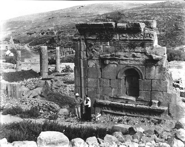
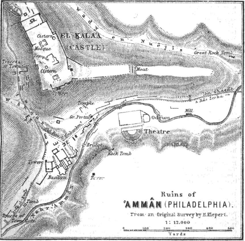
City and capital of Jordan on the Jabbok (Zarqa) River 48 miles ENE of Jerusalem (8). Amman lies at the head of a ravine in which the Jabbok takes its rise. Its elevation above the sea is 2,770 feet. It has been described as "a strong position shut in by high mountains and deep valleys ; an abundance of good water flowing through a narrow vale from the southwest to the northeast with a sufficient space on the left bank of the stream for edifices of all kinds, public and private ; while a large isolated hill some 300 feet high overhangs it on the northwest and north affording on its summit a broad platform for a large and almost unassailable citadel". The ruins of Amman cover a larger space than those of Jerash but they are not so well preserved. Traces of the ancient city of Ammon may be seen in the lower courses of the walls and in the substructures of the citadel (2). The earliest evidence of settlement in the area is a Neolithic site located on the outskirts of Amman known as Ain Ghazal. It was one of the largest Neolithic villages known in the Near East There is ceramic and flint tool evidence of human activity in Amman during the Chalcolithic Period (4500-3300 BC) but few remains of Chalcolithic settlements have been found to date (4). The focus of settlement from as early as the Early Bronze Age (3200–2000 BC) was the small high L-shaped plateau (modern Jabal Qalʿa) just north of the wadi (9). Fortified settlements have existed at the Amman Citadel since remote antiquity (6).
Amman derives its name from the 13th century BC when the Ammonites, a Semitic people frequently mentioned in the Bible named it "Rabbath Ammon" with the term Rabbath meaning the "Capital" (B). During this time it was engaged in a struggle with the Israelites that ended when King David captured the city circa 1010 BC. The “royal city” taken by King David’s general Joab (II Samuel 12:26) was the acropolis or citadel atop the plateau. The population of the Ammonite cities was much reduced under King David. Amman declined in later centuries. The history of Amman between the end of its Biblical references (around 585 BC) and the time of the Ptolemies is unclear (5). In the 3rd century bce it was conquered by Egypt’s King Ptolemy II Philadelphus (reigned 285–246 bce) and he renamed it Philadelphia after himself; the name was retained through Byzantine and Roman times ... The city later came under Seleucid and also Nabatean rule but the Roman general Pompey’s annexation of Syria in 64 BC and capture of Jerusalem one year later laid the foundations for the Decapolis League (4) ... Philadelphia was a city of the Decapolis, a Hellenistic league of the 1st century bce until the 2nd century ce. In ce 106 it was included in the Roman province of Arabia and rebuilt by the Romans; some fine ruins of their rule in this period have survived. With the coming of Christianity it became a bishopric among the sees of Palestina Tertia subject to Bostra. At the rise of Islam Amman was taken by the Arab general Yazīd ibn Abī Sufyān in ce 635; It was completely abandoned between the thirteenth and eleventh centuries from causes unknown to historians (6). Amman’s "modern" history began in the late 19th century when it was resettled by Circassians of the Shapsough tribe from the Caucasus in 1878 (A). They took refuge in the old ruins of Amman. Ottoman authorities encouraged them to settle in Amman and similar arable but abandoned areas in the hope of expanding the cultivated and hence taxable area of the Empire. This gave Amman a colloquial name that it bore only briefly: Khirbet Sharkas or the village/ruins of the Circassians (10). (7) Syria: the Desert & the Sown by Gertrude Lowthian Bell --- First Published 1907 ... Fellāh ul 'Isa and Namrud fell into an interesting discussion over the coffee, one that threw much light on the position of the tribes of the Belka. They are hard pressed by encroaching civilisation. Their summer quarters are gradually being filled up with fellahin and still worse, their summer watering places are now occupied by Circassian colonists settled by the Sultan in eastern Syria when the Russians turned them out of house and home in the Caucasus. The Circassians are a disagreeable people, morose and quarrelsome but industrious and enterprising beyond measure and in their daily contests with the Arabs they invariably come off victors. Recently they have made the drawing of water from the Zerka, on which the Bedouin are dependent during the summer, a casus belli and it is becoming more and more impossible to go down to Amman, the Circassian headquarters, for the few necessities of Arab life such as coffee and sugar and tobacco.
(1) East of the Jordan by Selah Merrill (1881)
The Roman road from Kulat Zerka to Amman can easily be traced at certain points. There are a few ruins in the valley and others among the hills both to the north and the south of it and one of these -- Rusaifeh -- on the north of the wady, must have been a city of importance. Along this valley many square miles which last year were covered with fine wheat are this year dry and barren. The land is allowed to lie idle one and sometimes two years. Then it is ploughed and irrigated and when seed is sown behold the desert plains become green and fruitful ! Below Amman a great many camels were feeding and there were hundreds of tents belonging to some of the Belka Arabs.
... It has been stated in some books that the bed of the Zerka, where it passes through Amman, was paved; but of such paving I find no traces. The natural bed is rocky and the stream is full of square blocks and broken columns that have fallen into it. There is evidence however that the stream, in portions at least, was covered and the space above levelled and perhaps paved, which would have added a great deal to the breadth and beauty of the city, to say nothing of the convenience to the inhabitants. CHAPTER XXXI --- A War-Cloud: Camp on the Shittim Plain March 28 1877 The whole region south of Amman and also north and west of it abounds in ruins. Amman itself was the chief city of the children of Ammon and it was also the chief city in that section of the country in Roman times. Jazer has been identified with Khurbet Sar, one mile west of Amman. If this identification is correct the "land of Jazer", famous for its cattle ranges, is the plateau region west of Rabbath Ammon (2). The Jazer region to the west of Amman, which the children of Reuben and Gad asked for because it was a place for cattle (Numbers xxxii), would be prized by agricultural people in any part of the world. It is not to be wondered at that the two and a half tribes were perfectly willing to stay on this side of the Jordan. Judea has no land to compare with it; neither has Samaria, except in very limited portions. Here common Arab trails broaden out into fine roads. Here are rich pasture lands and luxuriant fields of wheat and barley and the ignorant Bedawin who own the soil point with pride to the green acres that are spread out beneath the sun ...
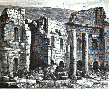
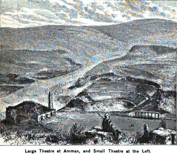
(3) Palestine and Syria: Handbook for Travellers by Karl Baedeker (Firm) 1876 History: Amman corresponds with the ancient Rabbath Ammon, the capital of the Ammonites. The sarcophagus of Og, the giant king of the Amorites, was once preserved here. The town consisted of a lower and an upper quarter. In consequence of an insult offered to the ambassadors of David it was besieged and taken by Joab. Later however it appears again to have belonged to the Ammonites. Ptolemy II (Philadelphus) of Egypt rebuilt it and added the name Philadelphia and for several centuries it was a thriving place belonging to the Decapolis of Peraea. It never quite lost its original name by which alone it was afterwards known to the Arabs. The destruction of Amman is chiefly to be attributed to earthquakes but notwithstanding all its misfortunes its ruins are still among the finest on the east side of Jordan. They are best described by De Saulcy (Voyage de la Terre Sainte 1865). The town lies in a fertile basin commanded by the ruins of a castle. On the right side of the brook, well stocked with fish, which intersects the town, lies the Theatre only with its back to the hill, a most impressive ruin and in excellent preservation. Descending the brook the traveller comes to the ruin of a mill. For a distance of 300 yards the banks of the stream are flanked with handsome Roman walls and the watercourse was once vaulted over here. The blocks lying in the water form convenient stepping-stones.
(2) The land of Israel; a text-book on the physical and historical geography of the Holy Land In the first reference to it in the Old Testament (Deuteronomy 3:11) it is called Rabbath of the children of Ammon. It was besieged by Joab two years before the lower city -- the city of waters -- was taken, and in front of its walls Uriah the Hittite was slain. (2 Samuel 11:16-17). The citadel was afterward taken by David. "And he took their king's crown from off his head, the weight whereof was a talent of gold with the precious stones: and it was set on David's head. And he brought forth the spoil of the city in great abundance" (2 SAMUEL 12:29-31). The prophetic denunciations against this city and its inhabitants have been strikingly and most literally fulfilled. (Jeremiah 49:1-2).
(11) A Handbook for Travellers in Syria and Palestine ... A short distance North of El-'Al (Biblical Elealeh) we enter the territory of the tribe of Gad which extended hence northward to the Jabbok. The road to Amman leads across the plateau, now bare and deserted but still capable of cultivation; and during the spring and early summer months covered with grass. Ruined towns are seen in every direction, generally situated on low hills. Rabbath-Ammon, Philadelphia, now Amman—The ruins of this ancient city are situated in a dreary valley on both sides of a little stream which in winter becomes a torrent. The source of the stream is a short distance to the west of the site and the water flows eastward. Nearly opposite the fountain another valley comes in from the north ; and on its eastern side at the point of junction rises up an isolated rugged hill on which stands the citadel commanding the town, and capable itself of separate defence. The aspect of the whole place is desolate in the extreme. The place is offensive too from its filth. The abundant waters attract the vast flocks that roam over the neighbouring plains and the deserted palaces and temples afford shelter to them during the noon day heat ; so that most of the buildings have something of the aspect and stench of an ill-kept farm-yard. Rabbath-Ammon is chiefly celebrated for the siege it stood against the Israelites under Joab during which the unsuspecting Uriah was slain through the contrivance of king David. Joab on his first attack took "the city of the waters" ; that is evidently the lower town situated along the banks of the river. But the citadel still held out; therefore messengers were sent to David asking for a reinforcement and the presence of the king himself; "lest" says Joab "I take the city and it be called by my name". David marched with an army and the citadel fell ...
(1) East of the Jordan by Selah Merrill (1881) (2) The land of Israel; a text-book on the physical and historical geography of the Holy Land embodying the results of recent research online by Robert Laird Stewart (1899) (3) Palestine and Syria: Handbook for Travellers by Karl Baedeker (Firm) 1876 (4) Amman: a brief guide to the antiquities by Rami Khouri (1988) (5) History: From Antiquity to Modernity --- Embassy of the Hashemite Kingdom of Jordan (6) Amman in ©2017 Encyclopćdia Britannica (7) Syria: the Desert & the Sown by Gertrude Lowthian Bell --- First Published 1907 (8) A list of Natural Syria's Leading Archaeological Sites by Adel Beshara (9) Jordan Treasure of Archaeological Sites in Copyright © 2012 Malhas Tours (10) The Exclusion of Amman from Jordanian National Identity by Ali Kassay in openedition.org (2011) (11) A Handbook for Travellers in Syria and Palestine by Josias Leslie Porter and John Murray (Firm) Part II 1868 Jordan by Carole French (2011) Ain Ghazal: A Major Neolithic Settlement in Central Jordan by Alan Simmons -- Ilse Köhler-Rollefson -- Gary O. Rollefson -- Rolfe Mandel and Zeidan Kafafi in Science Magazine (1988) 'Ain Ghazal / History of Amman in Wikipedia
|