|
Other Archaeological Sites / The Neolithic of the Levant (500 Page Book Online) Sumerian City-State Eridu and Ubaid Phase 1 (Tell Abu Shahrain) in Iraq ProofRead and Updated March 21st 2020
Excerpts and Definitions and Addendums: Sumerian myth tells how Enki built the house or temple E-Abzu for himself in Eridu, the oldest city in Sumer according to tradition --- the first of five cities founded before the Great Flood
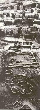
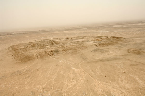
The earliest phase of occupation -- named the Eridu Phase -- is dated to begin circa 5400 BC; this is followed by the Hajji Muhammed Phase: both of these precede the fully developed Ubaid Cultural Period. They are often regarded as early or proto-Ubaid. The settlement at Eridu can also be regarded as proto-urban from the beginning; it grew into a substantial city by the Early Dynastic Period and two royal palaces of this period have been excavated. Outside the temple precinct a large cemetery of the late Ubaid Period was found; this contained perhaps 1000 graves of which circa 200 were excavated. Grave goods include painted pottery vessels, terracotta figurines and baked clay tools such as sickles and shaft-hole axes (ibid). The results of excavation on the main mound and the soundings made at the smaller mounds in the neighbourhood indicate that the area was inhabited continuously from the earliest known cultural period in Southern Iraq, namely the Eridu phase of culture (sixth millennium BC), down to approximately the end of the Achaemenid period (4th century BC) [Pages 30-1 4]. Eridu was abandoned for long periods [of time intermittently] before it was finally deserted and allowed to fall into ruin in the 6th century BC. The encroachment of neighbouring sand dunes and the rise of a saline water table set early limits to its agricultural base so in its later Neo-Babylonian development Eridu was rebuilt as a purely temple site in honour of its earliest history (11). ... Hence the temple platform was being used during the Jemdet Nasr Period (3100-2900 BC) even though the old abandoned city near the Eridu temple was buried under sand dunes. As Safar states [see 4 below] there was a settlement about a kilometer north of the temple mound. This may have been where the Enki priests lived after the old Eridu city became uninhabitable. There were also nearby coastal towns on the shore of the Persian Gulf that were occupied during the Jemdet Nasr Period (12). Eridu was reputedly founded by Enki the god of exceptional wisdom and strength who become the god of the subterranean sweet waters. The city’s importance was always more religious than political (2 and Page 34 4). In Sumerian literature Eridu is claimed as one of the most ancient cities in Mesopotamia, said to antedate the mythical Flood and to be the first city to hold kingship [albeit mythical] (Page 5 1). Eridu seems to have had no political significance and was never a seat of a ruling dynasty except for the first two legendary kings before the Deluge (4). After the kingship descended from heaven the kingship was in Eridug. In Eridug Alulim became king; he ruled for 28800 years. Alaljar ruled for 36000 years. 2 kings; they ruled for 64800 years. Then Eridug fell and the kingship was taken to Bad-tibira (Sumerian King List From The Electronic Text Corpus of Sumerian Literature). The Ubaid material culture complex in southern Mesopotamia is best exemplified by the material from Eridu. Nowhere else has such a complete architectural and ceramic sequence been recovered for this period (Preface Page 7 4). Eridu was one of the first centres of civilization in southern Mesopotamia and in its earliest phase was distinguished by a type of painted pottery otherwise unknown except for some unstratified sherds from Ur and Usaila near Eridu (ibid). ... Site number 8 is a flat patch of land on which Eridu phase sherds are scattered. It is situated at present in a shallow depression where rain water accumulates and hence shrubs grow here and water could easily be secured from pits dug by bedouins. For this reason it is called Usaila, meaning sweet water and although it is actually brackish nevertheless [it is] better than other places in the vicinity. This site is situated to the west of Abu Shahrein about 5-6 Kms away (Page 33 ibid). The steady development of this civilization is demonstrated by the repeated rebuilding of temples in the same place throughout the prehistoric period. The sequence of plan[s] recovered from the Temple Sounding starting as a simple one-roomed shrine in Level XVII just above virgin soil and ending as a huge and elaborate temple of the protoliterate period in Level I provides a vivid illustration of the evolution of religious architecture in Mesopotamia (Preface Page 7 ibid). At Eridu a sequence of sanctuaries underlies the large later sacred precinct of 2100-2000 BC, providing a continuity of temple building in the same spot from Ubaid 1 right through into the historical period. This is important evidence for cultural continuity despite the technological and political changes that occurred over 3000 years (Page 22 10). Ubaid 1 sometimes called Eridu (5400–4700 BCE) is a phase limited to the extreme south of Iraq on what was then the shores of the Persian Gulf. This phase, showing clear connection to the Samarra Culture to the north, saw the establishment of the first permanent settlement south of the 5 inch rainfall isohyet. These people pioneered the growing of grains in the extreme conditions of aridity thanks to the high water tables of Southern Iraq (6). ... The area lies beyond the rain-belt which made dry farming possible and was apparently shunned by farmers until the development of early irrigation systems in the middle of the sixth millennium. The earliest occupation hitherto discovered was at Eridu XIX-XV and is now known as the Eridu [phase of the Ubaid] culture. No building remains are known from the lowest level (XIX) and these may have been of a temporary nature. Four parallel walls of mud-brick mark level XVIII (sleeper walls 6) but above them a small rectangular shrine with two internal buttresses was erected in level XVII (Page 286 5 and Page 41 7). In this first phase, commonly designated the Ubaid I or Eridu Period, copious marsh resources were exploited in a sophisticated manner, part of a "broad-spectrum economy" that employed for instance canoes and nets for fishing. Ubaid origins on the southern alluvium were thus almost certainly around the marshes and watercourses: needless to say their *domesticates were not locally derived. Four sites of this phase are known: Eridu, Usaila, Ur and the type-site of Tell Ubaid itself (Page 128 8). Eridu, in spite of being located in a low-lying depression southwest of Ur, [has] an eight-meter scarp of the Upper Fats formation (the Hazim) running well to the north and south of it, possibly blocking any marine infilling into the depression. A survey of the Ubaid period in the region reveals that only four sites were occupied during the Ubaid 1 period including Ur and Eridu. While a marsh/riverine environment was exploited at Usaila (EP 104) west of Eridu there is no basis for suggesting that either of these two sites lay on a river channel or seashore. In later Ubaid times (Ubaid 3-4) it is clear that Ur lies on a major Euphrates channel and a series of sites northwest of Eridu could be interpreted as forming a possible southern channel. Eridu itself may have had close access to the sea since fish deposited in temples VIII-VI and the HM Sounding datable to the Late Ubaid period have been defined as marine or as sea-perch from brackish tidal waters. An actual southern channel of the Euphrates running through or by Eridu in fact is not known until later (9). But the sea in its climatic optimum of three metres higher than at present could probably just enter the depression by an opening at the Ridge of al Hazm to the west of Ur which is at present only about 9 feet above sea level. But more probably the water which filled the depression forming the great lagoons (Apsű) was fresh from the Euphrates ever existing at the head of Arabian Gulf. How long that rise of the three metres continued is not known but at Eridu the settlement which appeared for the first time outside Tell Abu Shahrein in the plain (in the Palace Sounding at the North Mound) in the middle of the Uruk Period in about 3300 B.C. may indicate that there was no more the threat of high water to the nearby plain (Page 33 4).
(4)
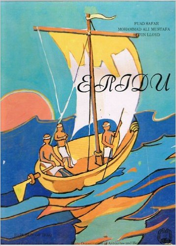
Eridu Fuʼād Safar, Mohammad Ali Mustafa, Seton Lloyd (1981) Access to the site, which had promised to present a major difficulty owing to the softness of the soil in the Abu Shahrein 'depression' was in the end greatly facilitated by the discovery of a causeway prepared for a road whose construction had apparently been abandoned at the outbreak of war in 1939 and which, crossing the depression in a southwesterly direction, passed within a few kilometres of the mound. When a track had been constructed connecting the site with the nearest point on this causeway, the railway station at Ur was brought within an easy one-hour drive by lorry, except after heavy rain, when the road would for some time become completely impassable (Page 29 4). In his memoirs Seton Lloyd wrote of “the almost total lack of building material” for “setting up base” at Eridu: “To solve this we [Lloyd and Safar] felt justified in looting the ruins of Wooley’s old expedition-house at Ur ten miles away and bringing in lorry-loads of baked bricks -- many of them stamped with royal names but beautifully intact (Footnote 10 Page 6 1). Eighteen successive levels of mud brick temple architecture dating from the Early Ubaid to the Late Uruk periods were exposed during the 1940's excavations on Mound 1; the painted pottery recovered provided the basis for the fourfold division of the Ubaid period. An extensive Ubaid period cemetery was also excavated. The remains of a ziggurat of the Ur III period dominate the centre of the mound. Early Dynastic palaces were excavated on mound 2 (Page 5 ibid). Excavations have uncovered 18 building levels of the remains of the temple of Enki, the earliest circa 5400 BC; a 12 X 15 foot room with an altar or offering table and a niche for the god’s statue -- features that endured throughout Mesopotamian temples. The temple was rebuilt in subsequent levels on a more ambitious plan and consisted of a central sanctuary and projecting lateral wings; [known as] the tripartite plan which became the characteristic architectural form for Mesopotamian temples (2). ... Eridu was probably founded close to the Persian Gulf near the mouth of the Euphrates but with the accumulation of silt over the centuries the remains are now some distance from the Gulf (ibid). See Therefore: "Based on the evidence that Eridu was a sea-port some four thousand years ago, though it is now perhaps a hundred and twenty-five miles from the Persian Gulf, one may calculate that about 7000 B. C. the Babylonian plain was just beginning to form and the site of later Babylon did not yet exist (3). On the other hand Sir William Willcocks has recently called attention to the fact that Eridu, though long an inland river town, might have been a sea-port on the river, like Bosra, and the fact that it was a port four thousand years ago does not show that it was on the Persian Gulf at that time (ibid). In response to my query regarding the distribution of the alluvium which had come down around Eridu in the last four thousand years, Sir William has very kindly written me explaining that in his judgment the delta had expanded sidewise [meaning, I take it, as one opens a lady's fan] and not by advance of the shore-line parallel with itself" (ibid). Eridu in History: In the Sumerian literature Eridu was on the sea shore at least in the time of Shulgi (2033-1988 BC) King of Ur according to the following cuneiform chronicle (Page 33 4). "Shulgi the son of Ur-Nammu cared greatly for the city of Eridu, which was on the shore of the sea" But was Eridu actually on the shore of the sea or was it on the shore of a great marsh [or lagoon] formed by the floods of the Euphrates ? Was the sea of Shulgi a mass of water regardless whether marine or fresh water? (ibid). Campbell Thompsons following statement has a bearing on these raised questions: "I think that the fresh water mussel shells which I found in great quantity in different strata when taken into consideration with the very few finds of marine shells will definitely compel us to give up the idea that Eridu was in ancient times actually on the sea-shore" (ibid). The conclusion of Thompson is confirmed by the fact that the main temple at Eridu was called E-Apsű, i.e. the temple of apsű or near by apsű which is the primeva[l] fresh water ocean (ibid). Nevertheless the possibility that the sea shore was [actually] near by Eridu could not be excluded since the geologists believe that the sea level in the climatic optimum in the middle of the fourth millennium B.C. was three metres higher than at present (ibid). The Cambridge Ancient History: But it is evident that in prehistoric times there must have been an abundance of fresh water -- the gift of Enki who dwelt in the apsű [water table] below the city. Something of this legacy still exists for in the low-lying ground at the foot of the mound the bedawin can still discover fresh water at a depth of about 6 ft. below the surface; this fresh water land is known by them as usaila. Although Eridu now lies nearly 150 miles distant from the Persian Gulf, at the time of its foundation and for many centuries thereafter it was probably directly connected with the seashore through a number of vast tidal lakes. Indeed the Sumerians themselves in their legends referred to the city in this way: ‘all the lands were sea ... then Eridu was made'. Geophysical investigations have however proved that these ancient historic statements need not be interpreted as meaning that Eridu was a maritime site but rather that it served as a port on a lagoon with direct communication to the Gulf. The evidence of stratification indicates that much of the ground in the neighbourhood was marshy (Page 331 5). * An animal or plant that has been domesticated
(1) Eridu Visit and Photos (Trustees of the British Museum)
AN ASSESSMENT OF ARCHAEOLOGICAL SITES IN JUNE 2008: (2) Tell Abu Shahrain (U.S. Department of Defense : Iraq : Cultural Property Training Resource) (3) Journal of the American Oriental Society Pages (1919) 178-9 (PDF) 49.4 MB
(4)
Eridu Fuʼād Safar, Mohammad Ali Mustafa, Seton Lloyd (1981) (5) The Cambridge Ancient History -- Volume 1 (6) Ubaid Period Wikipedia
(7) The Earliest Settlements in Western Asia:
(8) The Emergence of Civilisation: From Hunting and Gathering to Agriculture,
(9) The Early Settlement of Southern Mesopotamia: A Review of
(10)
Routledge History of the Ancient World : The Ancient Near East (11) Eridu (Wikipedia) (12) A BRILLIANCE HURTLED -- Evolutionary Origins by Appleton Schneider (2013) (13) Macmillan Dictionary of Archaeology Editor: Ruth Whitehouse (1983)
|