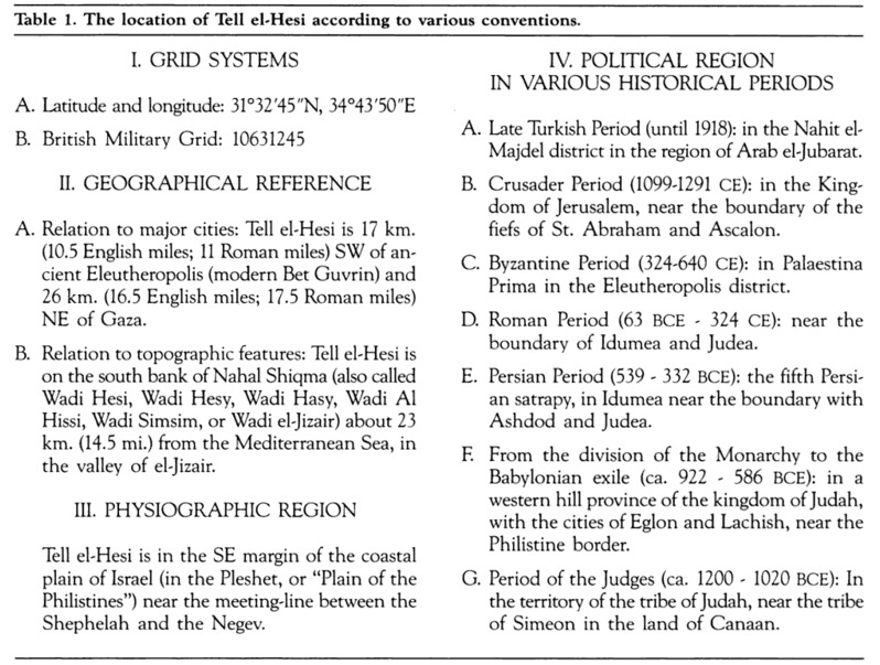
|
Other Archaeological Sites / The Neolithic of the Levant (500 Page Book Online) Tell el-Hesi Tell el-Hesi: Dictionary of the Ancient Near East -- Editors: Piotr Bienkowski and Alan Millard (2010) ProofRead and Updated April 23rd 2020
Note: Petrie identified Tell el-Hesi as the Biblical site of Lachish and Bliss accepted this identification; but it is no longer accepted. In 1924 W. F. Albright proposed that Tell el-Hesi was Biblical Eglon, an identification still accepted by Yohanan Aharoni in the 1970s. This identification too is unlikely and the site should be considered unidentified.
It was the first major site excavated in Palestine, first by Flinders Petrie in 1890 and later by Frederick Jones Bliss in 1891 and 1892 -- both sponsored by the Palestine Exploration Fund. Petrie's work there was the first stratigraphic excavation in Palestine (A and 3) ... A new era began with the work of Flinders Petrie at Tell el-Hesi in 1890. Petrie discovered from his examination of the mound of Tell el-Hesi first that tells were artificial, not natural mounds, formed by the accumulated strata of building debris over long periods of time; and second that each visible stratum of deposit contained its own distinctive types of pottery. Petrie produced a classified typology of the pottery taken from the different levels exposed on the mound. This gave a relative dating for the sequence of pottery which could then be used as an aid to dating similar levels elsewhere in Palestine; the discovery of Egyptian inscriptions or royal scarabs in a stratified context made it possible to link the scheme with the accepted Egyptian chronology and so produce a basic chronology for Palestinian material. The cross-linkage of stratified pottery with Egyptian and Assyrian inscriptional evidence remains vital to the establishment of the chronology of biblical history to this day (1) ... Tell el-Hesy by Sir William Matthew Flinders Petrie (1891)
CHAPTER I --- Introductory The work of excavation at Tell el-Hesy was the fruit of a permission which the Palestine Exploration Fund had long been endeavouring to obtain from the Turkish government ... I left Egypt and arrived in Syria in March 1890. On going to Jerusalem I found that the permission granted by the government had been delayed. I was thus detained for three weeks during which time I carefully examined the remains at Jerusalem (2). Having at last obtained the permission I went down to the village of Bureir, the nearest inhabited place to my area of work. After waiting for ten days more, at last the needful Turkish official arrived to watch the excavations and to take for the government all antiquities that might be found. I had while waiting at Bureir gone over the district allotted to me and seen each of the ancient sites ... Tell el-Hesy from its height and the pre-Greek style of its pottery seemed to me to be a very promising site; and I settled on attacking it although it was in the midst of the Bedawin and mostly cultivated. The Turkish official was here of use in doing all the communications with the innumerable Bedawi Shekhs and visitors who came about and so relieving me of much attention to them. I had six weeks of work there, including the whole of the month of Ramadan, when work is very difficult to the fasting and thirsty Muslims. But in that time and without disturbing the crop I succeeded in unravelling the history of the place and obtaining a long series of pottery approximately dated. It was well that I had not reckoned on continuing my work longer for at the last all my men deserted me to go to harvest and I could not get one even to guard my tents.
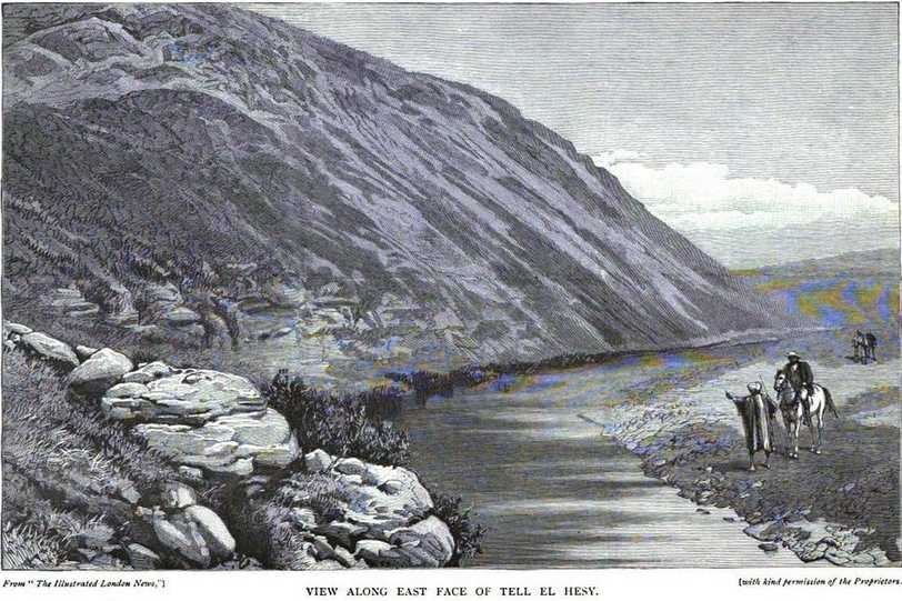
CHAPTER II --- Site of Tell el-Hesy The mound of Tell el-Hesy stands 16 miles east of Gaza, a little to the north: that is rather more than half way from Gaza to Beit Jibrin and a third of the distance from Gaza to Jerusalem. Though in the bottom of a valley, yet its height of over 100 feet makes it a conspicuous mark, both from the hill country when looking over the wide plain of Philistia -- and also in the view up the broad Wady Hesy from the west. This mound, for over 60 feet of its height, consists of successive ruins of towns piled one on the other. The houses were built of sun-dried clay bricks; every storm washed down somewhat from the walls and deposited the mud around the houses; every house that was ruined was partially broken down and helped to fill up the surrounding space; every gust of wind left some dust in the streets; and little by little the surface was thus raised, about half an inch each year until instead of a low swelling ground 50 or 60 feet above the stream at its foot, the mound when it was last occupied rose over 120 feet from the water. This gradual piling up of a mound of ruins is well known in Egypt where sun-dried mud bricks were also used; the mound of ruins of Damanhur is over 40 feet high and the mound of Tanis is as much as 80 feet. ... The surrounding soil and the top of the mound are now cultivated by the Bedawin; and it is only on its steeper sides that excavations can be made without the need of buying out the crops and of restoring the surface of the land for cultivation. CHAPTER VII --- The Pottery
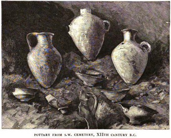
We now know that the varieties of Amorite pottery; combed-faced -- spouts -- ledge-handles -- hole mouths -- thick brimmed bowls and patterned burnishing are all peculiar to one period; that of the high civilisation which we see portrayed on the Egyptian monuments before the break up by the Israelite invasion. And so far as we know these styles are limited to Palestine. Neither Egypt on one hand nor Phoenicia on the other show any parallel to these peculiarities. Some of these varieties of Amorite pottery lingered on in a debased form during the Jewish monarchy; but as a whole they were first overthrown by the introduction of a desert race who cared little for pottery; and then the remnants were expelled by the Phoenician pottery style.
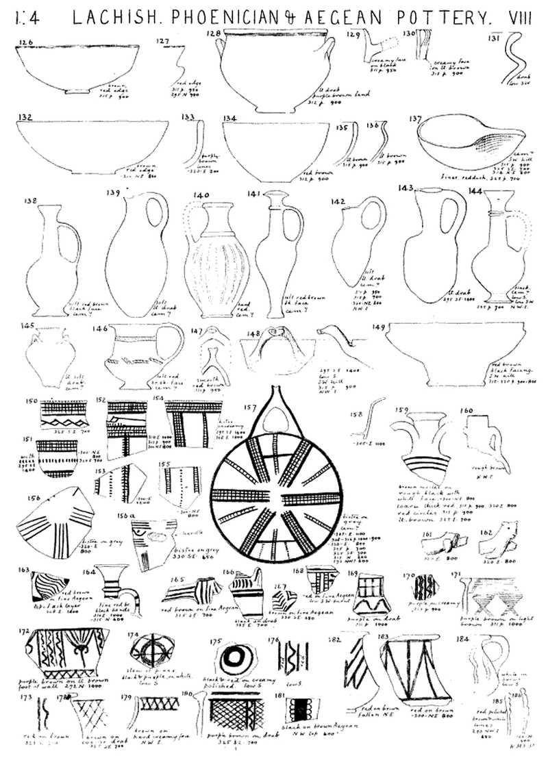
Phoenician Pottery -- We now come to a wholly
different style, the rough porous light brown bowls and jars which are found with characteristic Phoenician pottery. The
way in which these jars were buried has been described in mentioning the
cemetery. This pottery also supplies the earliest form of lamp, an open
bowl pinched up into a spout (137) ranging from 1000 to 600 B.C. and
supplanted by the Greek form of the same type. The thin black
faced is the most distinct Phoenician pottery. This is sometimes made of a softish brown-red body faced black; and sometimes of a hard homogeneous black paste of fine quality. The
vases of this form (138--141--144) are known to the Arabs by the name
of bilbil and it will be as well to use this for a name. They are common
in all Phoenician places, both in Cyprus and on the mainland, and are
found in Egypt as far up as Thebes. The Painted Aegean Pottery—Not many fragments of the early Greek style were found and these rather belong to the Aegean civilization before the rise of the Greek race. The pottery is certainly foreign by its fine hard paste and the painting is of the iron glaze. The earliest pieces are from about 1000 B.C. Some pieces of Aegean pottery with plain iron bands were found: buff with red brown lines from about 1000 B.C.; red bands on creamy-white face from about 800 B.C.; a buff and black handle from 750 B.C.; and a bowl with a broad red band inside from 700 B.C. All of these dates are within the period for Aegean pottery shown in Egypt, as there the geometrical Mykenae style is of 1400 to 1200 B.C. Jewish Pottery—By Jewish is here meant the styles which are neither pure Amorite nor Phoenician but which consist of a mixture of characters; they mostly have a uniform rough surface of red-brown pottery belonging to these later times of the Jewish monarchy. The Greek pottery begins to appear as early as 700 or 800 B.C. The most important case is that of the thick drab bowls with a smooth spherical inside and ribs outside. These are common at Naukratis on the west of the Delta, being found among the early dedications of the Apollo temple about 650 to 550 B.C. But they are wholly unknown in the Greek town of Defenneh on the Syrian road at just the same period. It is clear then that their use in Syria did not arise from the Greek settlements in Egypt, as they are distinctly absent on the line of communication, while common at a town much further off. They must therefore have resulted from a maritime intercourse; and the Greeks must have been trading with Joppa or Gaza, if indeed they had not settled in Judaea, as early as 700 B.C. This is not at all surprising as they were sufficiently strong to conquer Egypt under Psammetichos in 666 B.C. Seleucidan and Roman Pottery—It only remains for me to complete this history of the pottery by describing the later styles which were not found at Tell el-Hesy. The Seleucidan is generally of a hard warm light brown, smooth in texture but without any colouring -- facing or polishing. The Roman pottery is ribbed around on the outside of the vessels, sometimes so fine as to be a combing, sometimes in wide waves; this ribbing began in Egypt about 150 A.D. and is universal in the later Roman pottery of Palestine. It survived into Arab times here as well as in Egypt. The other characteristics of the Roman sites, which are the great majority in Palestine, are cubical white tesserae, glass of light green mainly, and of course Roman coins ...
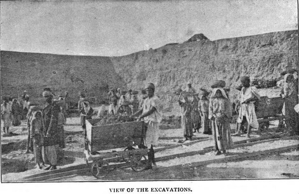
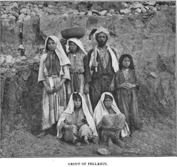
CHAPTER VII --- SKETCH OF THE EXPEDITION In the autumn of 1890 while staying in a lofty village of the Lebanon I was asked to carry on the excavations begun at Tell el-Hesy by Dr. Petrie. As work in Palestine could not properly be commenced before early spring I spent the month of January in a short apprenticeship to that most energetic of excavators at the pyramid of Meydun about forty miles south of Cairo. He was at once my inspiration and my despair; for his cordial patience in instructing my inexperience in the varied details of a digger's work was unfailing while his easy mastery of them all suggested a comparison in my own mind far from encouraging ... Towards the end of my stay his book on Lachish arrived and I retired with it for two days into the sculptured tomb of Ra-Hotep which furnished an atmosphere both artistic and serious, as befitted such archaeological studies. On February 16th I landed in Jaffa where I spent a wearisome five days arranging with a German carpenter of slow mental processes for the construction of a little tram-line and eight trucks. On arriving in Jerusalem I arranged with his Excellency Ibrahim Pasha for the services of an inspector of the excavations, required by the Turkish law, to take charge of the finds for the Imperial Museum at Constantinople. Violent storms detained us in Jerusalem till our patience was nearly exhausted but on March 5th we travelled to Ramleh. Since then I have easily ridden from Ramleh to Tell el Hesy in seven hours but our first journey took us all day as we had to hunt for the best places to cross the rain-swollen ditches. Towards sunset, approaching from the north-west, I had my first sight of the place that was to be my home for a good part of two years. About us was a world of rolling green broken only by the watercourses where the soil showed a rich bed; hardly a tree was to be seen; far away to the east stretched the pale-blue line of the rocky Judaean hills; below us wound the Wady el-Hesy and rising steeply above it was the tell with its rounded top, curiously marked by the trenches of Dr. Petrie. ... Not a house was in sight, only a few distant barns which the Bedawin build for their cattle and peasant-partners, disdaining to sleep in them even in the wildest weather; lines of their black tents stretched along the hollows here and there and at night we heard the sounds of merry chanting, the barking of dogs and the occasional report of a revolver. The west wind brought to our ears the boom of the sea fourteen miles away. Though we seemed to be so alone in the wilderness the news of our arrival spread and the very next morning peasants from Bureir (six miles off) appeared asking to be 'written down' as workmen. They were much impressed by my note-book with its lists borrowed from Petrie. 'Wullah they know everything' was the murmur of the bystanders when after inquiring a certain man's name I told him that we had no work for the lazy and the insolent.
Owing to the rain we did not break ground till
March 16th but meanwhile I spent my time at the
tell identifying Petrie's walls and other discoveries.
We began in the 'west city' with seventeen men each with a woman or girl to remove the earth in
baskets. An easy time the women had during the
first week as the men were working in trial trenches
which were afterwards refilled so that the earth
had merely to be tossed on one side. But the poor
women's turn came when we began work on the
tell. We began the work either at sunrise or a halfhour after and with an interval for lunch went on till within an hour and a half of sunset. The women had six miles to walk from Bureir before sunrise and six miles back at the close of the day when they had to draw water, grind corn and bake bread; so that it seemed only just to let them off before sunset. That first season the weather was most delightful with bracing nights, temperate days and few fierce winds. The party kept in fine health and spirits. When I closed the works on May 15th it was not because of the weather but from the lack of men who left for the wheat harvest; the best of them had gone three weeks before to reap the barley and the last day we had a small and sorry set of labourers; old men and young children, the maimed and the incompetent. If I could have kept a full force the work could have gone on quite comfortably for a month later. Early in October we were on the ground again. Very different appeared the country about Tell el-Hesy in the autumn. The green and red of the fields had faded into a dull monochrome of brown. No merry sounds reached our camp for the Arabs, fearing the deadly malaria which hung over the stagnant water below the tell, had withdrawn far away. Only at noon large herds of melancholy cows were driven to the wells in the stream-bed for their daily drink, to be driven away again on a hopeless search for nourishment from the barren fields. The work-people were dull and listless and one after another would fall ill during the hours of work. Out of our small camp of nine I was the only one to escape fever; the Effendi fell sick, my cook had to be sent to the Gaza Hospital, my foreman was laid up several times and the four guards were always giving out. It was a most sober season and as the days grew shorter and colder the amount of work done grew less and less ... In December the winter storms began in good earnest and we broke camp in time to spend Christmas in Gaza. On a clear cool day however the life of an excavator is enviable. To rise before the dawn breaks over the great still world; to precede the long picturesque line of workpeople to the tell: to follow from hour to hour the unearthing of a room; to see the handle of a pretty vase peeping out of the earth and to watch it brought out whole; to make the tour of the men towards the close of the day, marking the finds which should be brought to the tent; to blow the final whistle which releases the people, who plunge down the hill as eagerly as children run from school; to return to the tent for a cup of tea (blessed drink in the wilderness !) and for a quiet examination of the day's finds and then to take a glorious gallop on one's Arab colt, perhaps to meet the Gaza messenger who brings the precious post—these are joys as genuine as they are simple.
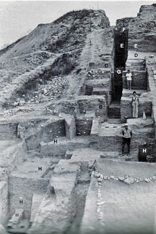
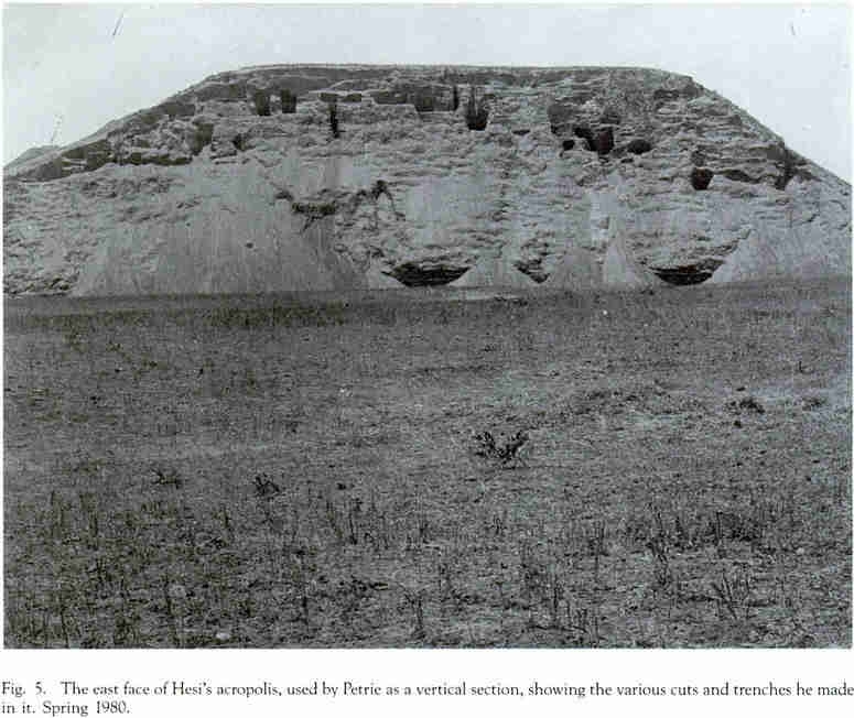
CHAPTER I --- THE ANATOMY OF A TELL In the rolling country which lies between the foot hills of the rocky Judaean mountains and the rich plain of Philistia, sixteen miles east of Gaza, a little to the north and twenty-three miles west of Hebron stands the mound called by the Bedawin Tell el-Hesy. A traveller approaching it from the north west in the early spring of 1890 would have been struck by its singular appearance. Other tells or mounds he would have passed, rounded usually on all sides; but Tell el Hesy, while gently rounded at the west, would have appeared to him steeper on its north and south sides but falling at the east almost precipitously 120 feet to the stream-bed below. This stream-bed is the Wady el-Hesy, joined a few hundred feet to the south-east of the tell by the Wady el-Kuneitreh. At all seasons of the year the water collects in pools from the brackish springs in the bed of the watercourse or stands in the purer basins scooped out to the depth of a few feet by the Arabs to reach the sweet water in other parts of the bed. Our traveller would have found the top and the west slope covered with a crop of barley while the east slope was a tangle of weeds and small bushes down to the rocky cliff of sandstone some forty feet above the stream-bed. A traveller of some 4,000 years ago however would have found no lofty hill commanding a view on every side but only a bluff some 60 feet above the stream-bed with a rolling country beyond. The visitor to the place to-day finds still another appearance which is indeed a combination of the other views. At the south and west the tell still preserves the high rounded sides it had in 1890; but its north east quarter appears as it did 2000 B.C. at the level of the bluff above the river-bed. Petrie had decided it was not worth the expense to buy the crops growing on top of the tell. It would have cost Ł4. He happily settled for the sides and especially for the eastern face which he saw as having great potential. “This is an excellent place to work as the storm floods have kept up so much scour as to leave the face a clean section from top to bottom so I can work at any period I wish”. He put groups of six men trenching on the slopes at different levels. One of the first fortification walls that appeared belonged to the earliest level of occupation which Petrie called “Amorite”, now known to belong to the Early Bronze Age (Page 43 5).
First: The earliest dwellings are not later than the seventeenth century B.C. and the latest belong to the fifth century B.C. Second: The great walls below the level of the ash-bed belong to the pre-Israelitish or Amorite times. The stones below the bed of ashes belong to the rude period of the Judges. The ashes represent a desolation when the tell was used by alkali-burners. The buildings above the ashes represent the cities of the various Jewish kings to the time of the Captivity. Third: The identification with Lachish, originally proposed by Major Conder [in the 1893 magazine Newbery House Magazine], was adopted for the following reasons: (I) The importance of its water supply as it commands the only springs in the region except those of Tell el-Nejileh 3 1/2 miles to the south; (2) its position, for it corresponds in general with the account in the 'Onomasticon' of the location of Lachish which was in the district of Daroma in the Shephelah or low country 7 miles from Eleutheropolis (Beit Jibrin) -- Tell el Hesy being about 10 miles from that place; (3) the correspondence of the remains in the tell with the historical notices of Lachish. The ancient name of Lachish, he thought, had been preserved in the later ruins of Umm Lakis, 3 miles to the north-west, perhaps occupied by the Jews when they returned from the Capitivity, too feeble to retake the more important site.
Jeffrey Blakely and Lawrence Toombs (1989)
 Archaeologists often referred to the importance of the work done by Petrie and Bliss and their pottery chronology and stratigraphic analyses continued to be influential but it was only in 1969 that serious consideration was given to renewed excavation at the site. From 1970 through 1983 the Joint Archaeological Expedition to Tell el-Hesi has conducted a total of eight seasons of excavation at the site in two four-season phases (1970-75 and 1977-83). Page 5 --- The earliest reference to the name Hesi is from the Third Crusade. Beha ed-Din reports that Richard Coeur de Lion rested his troops along the Wadi Hesi on his return (in June 1192) from the capture of ed-Darun (Beha ed-Din 1897: 337). Richard later used the Hesi region as a staging area for his attack on a caravan advancing against him from Egypt (ibid: 343). Page 11 --- When the mapping was done for their Survey of Western Palestine it was noted by Conder and Kitchener (1883: 256) that the Wadi Hesi formed the southern boundary for farming and that the region south of the wadi was left mainly for grazing. This apparently had been the practice in the past and many of the early pilgrims made comments about passing through fields of grain after crossing the Wadi Simsim (Wadi Hesi) northward. Traditional farming methods had to wait for the first rain to soften the ground before plowing. Much of the benefit of the early rains was lost. Since 1950 mechanized farming has allowed breaking of the ground before the first rain. This decreases the runoff of water and allows earlier planting. This in turn has allowed the farming to be pushed farther south so that the Wadi Hesi is no longer the southern farming limit. Farming here takes advantage of the region of highest dew (which reaches a maximum in the northern Negev where more than 250 days of dew occur each year). Survey of Western Palestine: Orography—Sheet XX includes 372.7 square miles of the plain of Philistia and of the low hills which bound it on the east. It is divided in the middle by the great valley called Wady el Hesy ... (6) North of this boundary-valley the plain is tilled by the inhabitants of the villages ; south of it the country is uncultivated and affords pasture to the Arabs. The hills are cultivated to about the same latitude. The average level of the plain is about 150 to 300 feet above the sea with a gradual slope down westwards. The eastern hills fall gradually towards the plain, being spurs from the Shephelah range. The hills are covered with scrub with a few olives round the villages. The plain is cultivated with corn ; and where there is water, with vegetables (ibid). HYDROGRAPHY—There is but little water in the plain or in the hills. Beit Jibrin is supplied by wells as are the villages near it. Those in the plain depend on cisterns and ponds. There is a brackish supply of water in Wady el Hesy for about 6 miles. The supply is however good and perennial (ibid).
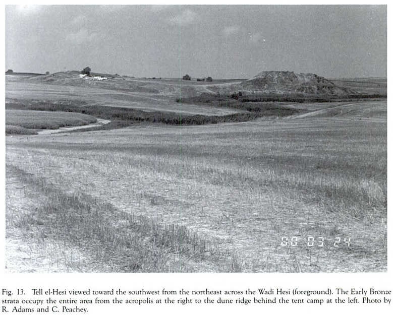
Page 21 --- Geomorphic History: the sharp 90° deflection in the course of the
Wadi Hesi just to the north of the tell has been
caused by ancient dune building along an abandoned Pleistocene shoreline of the Mediterranean
by processes similar to those that are producing the
present shore dunes. The record of past events is
well preserved in terrace-wall stratigraphy exposed
along the Wadi Hesi and in an excavation south
of Tell el-Hesi in a trench dug by Dr. David Gilard.
At the Gilard site evidence may have been
found of Upper Paleolithic pebble culture and horse
bones. This site represents a terrace remnant of a
swamp formed behind a dune complex that marked
an ancient Pleistocene shoreline. Such a swamp
environment existed behind the modern shore dunes
until quite recently when the swamps were drained
for malaria control. Page 25 --- Edward Robinson visited the tell in 1838 and described it as a “truncated cone with a fine plain on the top" (Robinson 1841: Volume II Page 390; 1856: Volume II Page 48). All written accounts of visits by pilgrims note the steep high slope on the eastern side. We now read starting from Page 44 of Biblical Researches in Palestine in the Year 1838 by Edward Robinson ...

Pages 26 and 27 --- The Basin: extending from the base of the tell
to the south and west is a broad low area which
has long been used for farming, but only in the
past few years has very deep plowing been done
there. Abundant sherds -- lithics and rock fragments
are found in the ash-rich soil over this whole
expanse and the annual plowing brings new
material to the surface each year. Into this basin
Petrie dug a series of probes to test the depth of
any occupation debris. He also traced
a segment of thick mud-brick wall at the basin’s
northern edge and he viewed both this and the
comparatively shallow layer of occupation debris
covering the basin as associated with the earliest
phase of occupation on the tell (Petrie 1891:31-32). A year later Bliss dug about 30 more probes into the basin west of the tell but he did not indicate their location or describe them except to state in one place that he dug over 17 feet to reach the underlying barren soil in his deepest probe (Bliss 1894: 22). Bliss also dug a 27.5 foot x 19.5 foot probe to a depth of 12 feet near the place where Petrie had found the wall on the crest of the north ridge. In this probe Bliss believed there could be as many as four phases of occupation representing the earliest occupation levels of the tell extending “probably to the period of the great bed of ashes"; which for him meant that these phases possibly included both the “Amorite” and the “Phoenician" periods; or (as this would be understood today) the Early Bronze and the Late Bronze periods respectively (Bliss 1894: 22-27 and 130). Petrie on the other hand had noted that pottery older than any found elsewhere on the site occurred in his probes of the basin. “The pottery found in the lower depths is not only Amorite in style but more archaic than any found in the city" (Petrie 1891: 31). The present expedition’s 1973 surface survey of the basin found a limited amount of Chalcolithic pottery in the area that supported Petrie's observation.
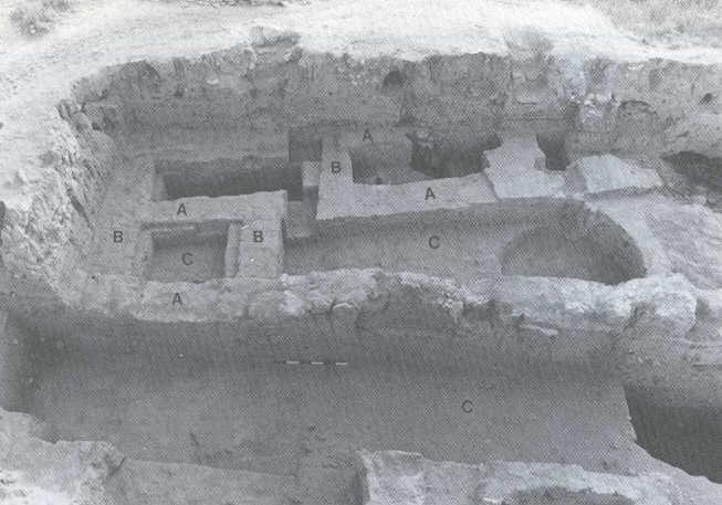
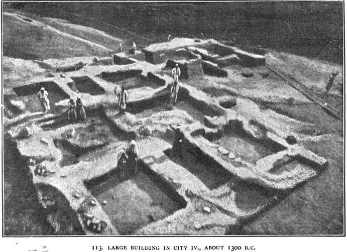
Structures of Stratum VIID built during the Iron II period. It is likely that in that period Hesi was one of a series of observations points to guard against invasions from Egypt or Edom and to protect the Judean farm lands. To aid this cause the height of the tell was raised by a series of walled chambers with fill placed in the middle. Evidence suggests that this took place during the reign of the Judean King Uzziah (783-742 BC) or possibly the reign of King Jehoshaphat (873-849 BC)
(A) Tel Ḥasi Encyclopćdia Britannica (7-20-1998)
(1) Archaeology and Biblical Interpretation by John R. Bartlett (2002)
(2) Tell el-Hesy by Sir William Matthew Flinders Petrie (1891)
(3) Tell el-Hesi Wikipedia
(4) A Mound of Many Cities or Tell el-Hesy Ecavated by Frederick Jones Bliss (1894)
(5) Tell El-Hesi: The Site and the Expedition by Jeffrey Blakely and Lawrence Toombs (1989)
(6) THE SURVEY OF WESTERN PALESTINE by CAPT CONDER and CAPT KITCHENER ---Volume III (1883)
(7) Biblical Researches in Palestine in the Year 1838: Revised Volume II by Edward Robinson (1856)
|