|
Other Archaeological Sites / The Neolithic of the Levant (500 Page Book Online) The Store-City of Pithom and the Route of the Exodus
Updated August 21th 2019
EGYPT EXPLORATION FUND (HathiTrust)
THE STORE-CITY OF PITHOM AND THE ROUTE OF THE EXODUS BY EDOUARD NAVILLE
WITH THIRTEEN PLATES AND TWO MAPS
Third Edition, Revised and Enlarged (1888) at HathiTrust ---
Fourth Edition, Revised and Enlarged (1903) at the Internet Archive ---
https://ancientneareast.tripod.com/PDF/The_Store_city_of_Pithom_and_the_Route_o.pdf
PREFACE The Memoir which I herewith have the honour of submitting to the public represents the first-fruits of the first excavations carried out by The Egypt Exploration Fund under the gracious authorization of His Highness the Khedive, during the spring-time of the year 1883.
I shall readily be believed when I assert that the life of the Egyptologist knows no keener delight than that of searching out the manifold secrets which yet lie hidden beneath the sands and mounds of Egypt. Of all pursuits which the hunting-grounds of his science have to offer him this is not only the most attractive and the most exciting but it is that which makes the largest demand upon our patience and which frequently rewards us in the most unexpected manner. In publishing therefore the results of this first expedition I hasten to seize the opportunity of paying a just tribute of gratitude to those founders and promoters of The Egypt Exploration Fund to whom I am indebted for my initiatory experience as an explorer in the Eastern Delta of the Nile. The first name which presents itself to my pen -- the name of Sir Erasmus Wilson, the enlightened patron of Egyptology in England and first President of The Egypt Exploration Fund -- recalls the heavy bereavement which the Society has recently sustained in the loss of that eminent man whose commanding intellect ranged over the widest domains of knowledge and whose nobleness of character and inexhaustible liberality have graven an ineffaceable record upon the age in which he lived. I also tender my acknowledgements to the members of the Committee and especially to the two Honorary Secretaries -- Miss Amelia B. Edwards and Mr. Reginald Stuart Poole -- to whose indefatigable zeal the foundation and popularization of the Society are due and to both of whom I am much indebted for their constant support
and also for their valuable assistance in the revision of this Memoir for the press. To my illustrious friend M. Maspero, Director-General of the Museums of Egypt, I offer my warm thanks for the cordiality "with which he welcomed me as a fellow-worker on Egyptian soil and for the invaluable way in which he furthered the objects of my mission by instructions to the local authorities. Nor must I omit the names of either M. Jaillon, the distinguished French engineer, or of my learned compatriot, Professor Paul Chaix; the first of whom not only furnished me with the necessary labourers but himself shared in the daily toils and anxieties of the work, while the second has kindly taken upon himself to prepare the Map by which this Memoir is illustrated.
In the deductions which I have drawn from the inscriptions discovered at Pithom I well know how much is conjectural; but I venture nevertheless to hope that this brief essay may at all events incline the public to appreciate the important ends to be attained by the exploration of Lower Egypt. Not mere antiquities for exhibition in the galleries of museums, not even works of art, no matter how great their artistic value, are the main objects of our quest; but rather the solution of important historical and geographical problems and the discovery of names, of facts and if possible, of dates.
My reward will be great should the perusal of these pages awaken a more general interest in Egyptology which, as a field of study, embraces a period of more than forty centuries and as a field of exploration is of vast extent, of unexampled wealth and in many parts comparatively unknown.
The plates and maps have been executed by the Typographic Etching Company
EDOUARD NAVILLE, Malagny, near Geneva, August 1884.
PREFACE TO THE THIRD EDITION
The first edition of this Memoir was, as I said in the Preface, the first-fruits of the work of the Egypt Exploration Fund which has since gone on from year to year in several parts of the Delta. While my friend and colleague Mr. Flinders Petrie discovered Naukratis and Daphnae I attempted several places in the Ouadi [Wadi] Tumilat. None of them except Bubastis, which I have only just begun, has given such important results as Pithom. However the work at Saft el Henneh, Tell Rotab and Tell el Yahoodieh has brought some additional light on several questions raised in this Memoir. When therefore the Committee of the Fund desired a new edition of this Memoir to be published, I thought it could not be done without a careful revision, completing the evidence, correcting the translations, filling up some gaps, answering objections put forward by high authorities and stating where my views may have been modified. The reader will see that a good deal more has been translated of the great tablet of Pithom. The text itself has been revised from a new set of paper casts. The Appendix I, which answered an article of Lepsius written nearly two years before the publication of the Memoir, has been replaced by another discussing objections raised by French and German scholars on my interpretation of Herodotus. The changes in my views bear only on questions of detail; in fact they consist chiefly in my admitting the existence of two Clusma and fixing the site of Serapiu Pikerehet a little farther south. It has necessitated the drawing of a new Map. But the main points of the paper are the same and especially what I consider to be the route of the Exodus. A more thorough knowledge of the country has not led me to alter the direction which I proposed and which seems to me in accordance with the circumstances and the nature of the land.
EDOUARD NAVILLE Malagny, near Geneva, November 1887
TELL EL MASKHUTAH On the south side of the sweet water canal which runs from Cairo to Suez through the Wadi Tumilat about twelve miles from Ismailiah are the ruins of European houses now abandoned but where a few years ago was a flourishing village. This was one of the chief settlements of the engineers and workmen who dug the Ismailiah canal and there was at that time a railway station at this point. The Arabic name of the place is Tell el Maskhutah -- "the mound of the statue". The French have called it Ramses.
None of these names are ancient. The Arabic Tell el Maskhutah is derived from a monolithic group in red granite representing a king sitting between two gods. This monolith has been described by the French engineers who surveyed Egypt at the end of the last century. The place was then called Abou Kachab or Abou Keycheyd. We know from the valuable memoir of the engineer Le Pere that "these ruins bore all the characteristics of an Egyptian city" among them being a very remarkable monument of which he speaks as follows : "It consists of a monolith of granite cut in the form of an arm-chair on which are seated three Egyptian
figures apparently belonging to the priestly order as one may judge from their costume and the caps they wear. The monument is still standing upright and the figures are turned towards the east. They were buried up to the waist; but having dug down to the feet we have been able to see the whole of them and to measure them. The back of the arm-chair is entirely covered with hieroglyphics which have the appearance of a regular and complete picture. Among the ruins are many blocks of sandstone and granite inscribed with hieroglyphics and all such remains as mark the sites of destroyed cities in Lower Egypt".
Since the above description was written the aspect of the place has changed. The numerous blocks of which the Frenchman speaks have been removed or covered by the sand ; and till a few years ago the site of the old city was indicated only by a hardly discernible mound or rather an undulation of the ground on the top of which stood the monolith; the size and execution of which showed that it must have belonged to a temple of some importance.
The inscriptions have been published and deciphered. They show that the three figures represent Rameses II between two solar gods, Ra
Page 2 The mound or Kom of Maskhutah is situated on the southern side of the present canal, the high banks of which are crowned by the earth works thrown up by Arabi Pacha's soldiers. Before the making of the Ismailiah canal this place was watered by an older work called the canal of the Wadi which is now only a marsh full of reeds. Moreover it is still possible to trace the bed and part of the banks of a much older channel, the canal of the Pharaohs, re-established by Ptolemy Philadelphos and again by the Emperor Trajan. It skirted the south-eastern side of the city. Standing on the bank of the canal and looking from Arabi's redoubt towards the desert, we first note two sides of a very thick wall meeting at right angles and constructed of very large bricks. The northern side rises above the sand to a height of some two or three yards. On the western side it used to be entirely covered by sand ; but it was laid bare a few years ago and its great width (eight yards) gives it the appearance of a causeway. The angle of the southern side is still discernible ; but that part is entirely covered by the villa Paponot. It is easy to trace the direction of the eastern side and to reconstruct the plan of the whole enclosure ; but on that side, owing to the vicinity of the old canal, the wall has very likely been destroyed to make way for the houses of the inhabitants. At the time when the villa was constructed nothing except the monolith and the northern side of the enclosure could be seen above the sand. One day however, in digging for the garden, the work men came across another monolith of the same size as the first; the pair having once stood symmetrically at the entrance of some edifice. Concluding that these monuments flanked each side of an avenue, M. Paponot continued the excavations in the same direction. The result was the discovery of two sphinxes in black granite, placed also on each side of the avenue or dromos ; then, farther on, a shrine or naos in red sandstone, very well executed and a large stele in red granite which was lying flat and had been used as the foundation of a Roman wall of baked bricks. The discovery of these monuments, which all belong to the reign of Rameses II, seemed to offer additional evidence in favour of Lepsius's theory that this was the site of Raamses. M. Maspero, who published some of them, came also to the conclusion that it was a city of Raamses; perhaps that of the Israelites, the starting point of the nation going to conquer the land of Canaan. This however was not yet a well established fact. The geography of the eastern part of the Delta is not nearly so well known as that of Upper Egypt. We are acquainted only by name with a great number of its cities, canals and lakes. Not only in the hieroglyphical lists of nomes which are inscribed in several temples but in the writings of the Greeks and Romans, we have a great deal of information regarding the Delta, which was visited by several invading armies and by a considerable number of traders Page 3 Owing to the uncertainty in the determination of localities, two very different theories have been started as to the route of the Exodus and the sea which the Israelites had to cross. The old theory makes them start from Wadi Tumilat and cross the sea somewhere in the neighbourhood of Suez. The new theory originated by Dr. Schleiden and Brugsch supposes them to have departed from the country round Tanis and maintains that the crossing of the sea must be under stood as meaning that the Israelites followed a narrow causeway between the Mediterranean and the Serbonian bog. That dangerous track still exists at present and is subject to be wholly washed over when there is a heavy sea. This last theory, which has been advocated with a great deal of learning and supported by very ingenious arguments, has occasioned much discussion, not only among Egyptologists, but also among those who take interest in biblical geography. On which side lay the truth? Would it ever be possible to arrive at any certain conclusion or at least to find one or two definite points of that famous route ? The desire to come nearer if possible to the solution of the Exodus problem induced the Society to choose Maskhutah from among the various localities where the kindness and the liberality of M. Maspero allowed excavations to be made. And thus the great task of the exploration of the Eastern Delta was begun. Before attempting to excavate it was necessary to study the monuments formerly discovered near M. Paponot's villa by the French engineer M. Jaillon and now deposited in one of the squares of Ismailiah. They consist, as has been said before, of a monolith of red granite ; a great tablet of the same stone ; two sphinxes in black granite ; and a broken naos of red sand stone of the same style and material as those which may be seen at San (Tanis). The naos is also a monolith but the inner part is not empty. It contains a recumbent sphinx with a human head, not detached, rising from the floor. One sees at first sight that all these monuments have been dedicated to the god Tum of whom the other form is Horemhku -- Harmachis, the same who was worshipped at Heliopolis. It is he who is represented on both sides of the tablet, once as with a human head bearing the double diadem and once as Harmachis with a hawk's head surmounted by a solar disk. Another emblem of Harmachis is the sphinx with a human head of which a gigantic example is seen in the sphinx near the Great Pyramid. Each time Rameses II is mentioned he is spoken of as the friend of Tum or Harmachis. It is clear therefore that Tum was the god of the city. It is true that the name of Pi Tum, the abode of Tum, is not to be found on the monuments of Ismailiah ; but it may have been carved on the
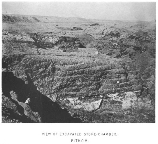
Page 4 The result of this preliminary study was therefore to show that according to all probability the city which would be discovered at Maskhutah was not Raamses but Pithom, the city or the abode of Tum. This conjecture has been entirely borne out by the results of the excavations. I began working on the 5th of February with the most obliging and effective help of M. Jaillon who brought with him a gang of about one hundred workmen ; a considerable facility in a place absolutely desert and where it was necessary to remove a great quantity of sand ; for as the monuments were neither very numerous nor very large it is likely that nothing at all would have been found had we only set a few labourers to dig here and there. We excavated first the south-eastern angle of the enclosure not far from the place where the former monuments had been discovered between the monolith and the enclosure. There the kom or mound rose to its greatest height ; and there also it seemed likely that we should find the remains of the old temple. We also worked much nearer the bank of the canal on a large undulating space separated from the enclosure by a sort of valley. Not far from there some rude stone coffins had been found while the canal was being made and it might have been thought that it was a necropolis. But this proved not to be the case. Although we went to a great depth under several of the mounds, we found nothing but crude brick of small size, clearly belonging to the Roman period. These were the house-walls of the ancient inhabitants. No monument of any importance was found there ; but only copper coins, fragments of hard stone which had been used as mortars and a great quantity of broken pottery of the coarsest description; cups, jugs and large anaphoras, some of which were perfect and are now in the Museum at Cairo. Within the area of what I regard as the sacred enclosure the excavations were carried northward in the line of the dromos of the temple ; and then beyond that area we laid open a large space of perfectly level ground which concealed the thick walls of the store-chambers. Shafts were also sunk in various places which brought to light everywhere brick walls of different periods which illustrate the history of the city of Pithom.
|