Wadi Tumilat --- G.D.MUMFORD

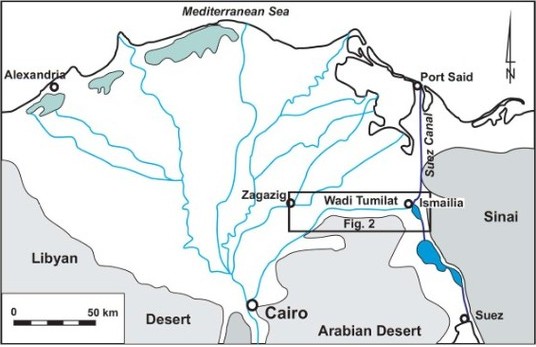
 The Wadi Tumilat today is a narrow intensively cultivated valley some 52 km long but
only 2-6 km wide leading eastward from the town of Abassa to Ismailia and the shores of
Lake Timsah. It is one of the two main overland routes leading from the Nile Delta to the
Sinai and western Asia and is heavily traversed today. Geologically it is the ancient bed
of a large Pleistocene river down-cutting through earlier Plio-Pleistocene deltaic sands
and gravels which today form the northern portions of the Eastern Desert. The Wadi is
bounded on the north by the Tell el-Kebir island, a turtleback of deltaic sands and
gravels, and on the south by a line of sand dunes bounding the northern edge of flat level
desert.
The Wadi Tumilat today is a narrow intensively cultivated valley some 52 km long but
only 2-6 km wide leading eastward from the town of Abassa to Ismailia and the shores of
Lake Timsah. It is one of the two main overland routes leading from the Nile Delta to the
Sinai and western Asia and is heavily traversed today. Geologically it is the ancient bed
of a large Pleistocene river down-cutting through earlier Plio-Pleistocene deltaic sands
and gravels which today form the northern portions of the Eastern Desert. The Wadi is
bounded on the north by the Tell el-Kebir island, a turtleback of deltaic sands and
gravels, and on the south by a line of sand dunes bounding the northern edge of flat level
desert.
Rainfall in the Wadi Tumilat is sparse and erratic, insufficient to sustain settled
occupation. Ordinary Nile floods regularly reached the western section of the Wadi,
which was bounded by a large natural dike, the Ras el-Wadi, in the region of Tell er-
Retabah and the modern Qassassin. Only exceptionally high Niles reached the central and
eastern sections of the Wadi, replenishing Lake Timsah to the east and the many small
lakes in the central section of the Wadi. As a consequence, the western end of the Wadi
(about 24km) was more heavily alluviated, and had more arable land. The depressed
central region of the Wadi probably contained a perennial marshy lake sustained by the
yearly Nile flood. Economic activities may have included farming, grazing, hunting and
fishing in and around the lake.
During much of antiquity, the Wadi Tumilat appears to have been largely deserted.
Settled occupation from the Middle Kingdom (?) onward is attested only at Tell er-
Retabah, located on high ground at roughly the Wadi’s midpoint; this site may have been
the “Walls of the Ruler” mentioned in the texts Sinuhe and the Prophecy of Neferti. The
only two periods in which the Wadi was intensively occupied were the Second
Intermediate Period, when there was a considerable Asiatic (Hyksos) presence in the
middle section of the Wadi, and the Late period, i.e. the later Saite through early Roman
periods. Neko II of the 26th Dynasty initiated the great sea-level canal linking the
Mediterranean to the Red Sea, a project successively given renewed effort by Darius the
Great, Ptolemy II and Trajan.
In the New Kingdom, the written evidence indicates that the Wadi Tumilat belonged
to a military zone, known as Tjeku (TkĄ), Both the orthography of the word and the
context of the references imply that Tjeku was a district rather than a town, although its
specific boundaries cannot be determined. The early occurrences of Tjeku all carry the
throw-stick and hill country determinatives, rather than the city determinative.
Identification of particular fortifications mentioned in the New Kingdom texts with
archaeological sites is difficult. The one exception is the “Fortress of Merneptah-Content-
with-Truth” of Papyrus Anastasi VI, which Redford has equated with Tell er-Retabah.
The archaeological data indicate the presence of a major stronghold at Retabah during
late New Kingdom times, and little or no occupation elsewhere in the Wadi. Inscribed