|
Other Archaeological Sites / The Neolithic of the Levant (500 Page Book Online) Neolithic Hajji Firuz Tepe in Iran
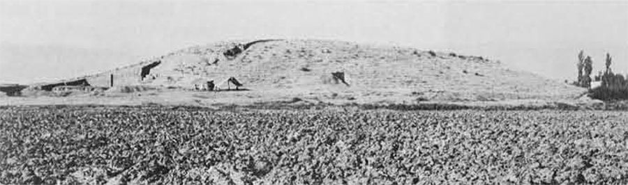
Hajji Firuz Tepe is a Neolithic village in Iran's northern Zagros Mountains. A major step forward in our understanding of Neolithic winemaking came from the analysis of a yellowish residue inside a jar excavated by Mary Voigt at the site. The jar was found together with five similar jars embedded in the earthen floor along one wall of a kitchen of a Neolithic mudbrick building dated to circa 5400-5000 BC (1).
(2) Hajji Firuz Tepe Iran: The Neolithic Settlement: Hasanlu Excavation Reports: Volume I Excerpts and Definitions and Addendums: (PDF Download Page) 650 MB [535 Pages] Bibliography (PDF) 41.2 MB [12 Pages] Chapter I: General Problems and Research Objectives (Page 1)
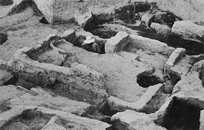
In order to obtain information bearing on these questions one site was chosen for intensive archaeological investigation. Hajji Firuz Tepe, a small mound located in the Solduz valley (south of Lake Urmia), was known to contain well preserved strata dating to the second half of the sixth millennium. Previous test excavations at this site had shown that architectural remains dating to the sixth millennium lay within a meter of the present surface of the mound in some areas so that a substantial portion of the early village could be cleared with a minimum of effort. New "area" excavations were therefore undertaken at Hajji Firuz Tepe in 1968. The research conducted in 1968 was designed to recover data which could be used in reconstructing all aspects of the material culture and behavior of the early villagers at Hajji Firuz; however a special emphasis was placed on the reconstruction of their subsistence system and on the economic organization of the community. The test excavations in 1958 and 1961 had provided little direct evidence for the kinds of plants and animals exploited by the sixth millennium villagers: animal bones were rare and no floral remains were recovered. T. Cuyler Young, who had directed the 1961 excavations at Hajji Firuz, nonetheless felt that agriculture was "strongly suggested” by the presence of large pottery storage vessels and the fact that a “permanent" (mud walled) settlement had been constructed (1962:707). Young's interpretation was based on Robert Braidwood's model of cultural evolution in the Near East which stated that sedentary communities were possible only when groups had some control over their food supply; that is they could rely to some extent on domesticated plants and/or animals. This model, supported by the results of Braidwood's field work in lraq, was widely accepted in the early sixties. The correlation of settlement type and subsistence economy was expressed in terms such as “established food-producing settled village type of economy" (Braidwood 1952:5) and "primary village farming community” (Braidwood and Howe 1960:1-5). Data collected between 1962 and 1968 forced a reconsideration of this ideal type. Sites such as Bouqras and Mureybat in Syria and Ain Mallaha in Israel yielded the remains of permanent structures but the groups which occupied these settlements apparently depended solely on wild plants and animals for subsistence (Ducos 1969; Reed 1969:367-368; Renfrew 1969b:158) (A). (A) The data from these sites in Syria and Israel have not only led to a rejection of the Braidwood model but have also been used in the formulation of a new evolutionary scheme which assumes that sedentary life is a precondition for plant and animal domestication (see Binford l968; Flannery 1969; Wright l979; but also Braidwood 1967:109-110). The fact that early villages could and did exist without the exploitation of cultivated plants and/or domesticated animals meant the subsistence economy of the villagers at Hajji Firuz had to be regarded as wholly unknown: although it was probable that they like the rest of the Zagros settlers were farmers, it was possible that they were collectors exploiting a new and highly favorable environment. Definition of the subsistence economy required that great care be taken during excavation in order to insure the recovery of floral and faunal remains. Initially it was thought that the use of flotation would be highly productive as it had been at Tepe Ali Kosh in southwestern Iran (Helbaek 1969). Unfortunately the soil at Hajji Firuz Tepe proved to be unsuitable for water flotation and only a small sample of seeds and vegetable fragments was recovered. Animal bone was also scarce and virtually all the faunal remains were picked up as the soil was loosened and removed rather than in sieving. Additional information on subsistence activities was obtained from an analysis of the tool kit but again the sample was small. Ideally the area around the village should have been tested in order to locate the sixth millennium fields or gardens. Such tests would however have to have been a meter or more in depth in order to penetrate relatively recent soil deposits on the plain surrounding the mound. Given the number of tests that might be necessary to locate a surface securely datable to the sixth millennium and that also bore evidence of cultivation, this type of research would have been feasible only with the aid of earth moving machinery --- a resource which was not available in Solduz in 1968. Thus the quantity of evidence recovered in the 1968 excavations from which the subsistence system could be inferred was disappointingly small; nevertheless it has permitted the formulation of a reconstruction which can be tested through further excavation and surface survey. A reconstruction of the economic organization of the village could be attempted if adequate information on settlement pattern and the distribution of artifacts and debris within the settlement was recovered. Young had defined a sequence of building levels in 1961 but he was not able to document the complete plan of any single structure: the lengths of mud wall which lay within his excavation area were difficult to interpret because of the lack of a complete building plan; that is a pattern against which fragments of structures could be matched. Clearance of a single occupation level over a large area was undertaken in 1968 resulting in the recovery of a relatively large number of structures and features. Regularities in plan, size and orientation could then be discerned as well as the spatial relationship of structures and features within the settlement or what has been called the ”community layout" (Trigger 1968:60-68). An attempt has also been made to isolate “activity areas” or to determine the location of specific types of behavior within the village. The function of both interior (roofed) and exterior (unroofed) areas is inferred in the analysis presented here from two types of data: 1) the plans of domestic structures and the location of features such as hearths, ovens, pottery kilns and storage facilities; and 2) the spatial distribution of artifacts for which specific functions can be suggested on the basis of ethnographic analogy and of the debris from the manufacture of artifacts. In theory it should be possible to reconstruct a variety of behavioral patterns by relating material remains to activities and then analyzing the distribution of such activities within a settlement. In fact, the excavated material from Hajji Firuz Tepe does permit inferences about patterns of economic behavior and therefore a reconstruction of the economic organization of the village. The second major problem set for the 1968 research was to determine the relationship between the group which occupied the settlement at Hajji Firuz and other groups in Greater Mesopotamia which were contemporary or which preceded them. The evidence available suggested that the Hajji Firuz villagers were colonists who moved into the Ushnu-Solduz valley some time after 6000 BC rather than indigenous hunters and gatherers who adopted a sedentary way of life. No evidence of an earlier occupation had ever been found in either Ushnu or Solduz despite surface surveys conducted by members of the Hasanlu Project. The only evidence for any human exploitation of the Urmia basin before the sixth millennium came from Tamtama Cave near the town of Urmia. Excavations by Carleton Coon at this site produced 24 chipped stone artifacts: 10 pieces of “use nibbled" flint and14 pieces of debitage (Coon 1951:36). The only conclusion that Coon was willing to draw from his data was that “man was there" at some time during the Pleistocene (1951:65). When the 1968 season of excavation at Hajji Firuz Tepe was planned and the research objectives were formulated the mountains and high valleys around Lake Urmia were virtually unknown archaeologically and most of the surrounding low valleys and plains had been surveyed only haphazardly. It therefore seemed possible that intensive surface survey might locate sites dating to the Pleistocene and early post-Pleistocene periods. During the summer of 1968 Ralph and Rose Solecki led a survey expedition which was specifically aimed at the recovery of Paleolithic and early village sites; however none were found in the valleys, hills and plains bordering the lake to the south and west (Solecki 1969:189). The area to the west and northwest of the lake was surveyed during 1968 by Regnar Kearton and again nothing predating the sixth millennium was found (Kearton 1969). Thus the hypothesis that the Hajji Firuz villagers were colonists from some other geographical region still stands, supported by additional negative evidence. These colonists appear to have occupied most of the Urmia basin, since Kearton’s surface material and the artifacts recovered from the basal deposits at Yanik Tepe to the east of Lake Urmia (Burney 1964) strongly suggest that all of the sixth millennium groups in the area shared a common ceramic tradition. The question of the origin of these groups (or of the “Hajji Firuz Culture") had been briefly dealt with by Dyson in 1965. He suggested that the pottery found at the sites in Azerbaijan might be “derivative from some early Hassuna or Hassuna-like culture in Mesopotamia" even though there were “some links" to Tepe Sarab, a site in the central Zagros (Dyson 1965a:218). Dyson's suggestions were based primarily on similarities between painted pottery found at Tell Hassuna and at Hajji Firuz. Young on the other hand chose to emphasize technological variables in the ceramic industry and considered “cultural connections between the pottery of Hajji Firuz and Tepe Sarab” to be an indication of contemporaneity and (presumably) cultural relationship despite other "striking dissimilarities" between these sites (1962:707). The excavations in 1968 provided a much larger and more varied sample of the archaeological assemblage at Hajji Firuz Tepe, allowing the comparison of multiple aspects of the material culture rather than concentration on a single industry. The artifact parallels documented in this site report indicate additional links with Hassuna groups and confirm Dyson's hypothesis of a relationship between the Hajji Firuz colonists and early Hassuna settlers in northern Mesopotamia. Major differences in the subsistence pattern and economic organization between Hajji Firuz and contemporary historically related groups in Mesopotamia (the later Hassuna and Samarra "cultures") have however been documented. These differences suggest that several types of adaptation evolved during the sixth millennium in Greater Mesopotamia and that the unilineal evolutionary model, which stresses the development of state societies dependent on intensive agricultural systems, is an over-simplification. In summary the goal of the field work undertaken at Hajji Firuz Tepe in 1968 was to clear a broad area of a sixth millennium village in order to obtain building plans and some idea of the overall plan of the settlement as well as a large sample of associated artifactual and non-artifactual remains. These data as well as information gathered from earlier excavations at the site and from surface surveys in Solduz and Ushnu have been used to fulfill the general goal of this research: a reconstruction of the economic activities carried out by the villagers and the way in which these activities were organized; and an assessment of the relationship of this economic system to the general history and evolution of culture in Greater Mesopotamia. Chapter II: The Excavations at Hajji Firuz Tepe: Description of the Mound (Page 7) Hajji Firuz Tepe is located in the northeastern portion of the Solduz valley approximately two kilometres to the southeast of Hasanlu Tepe. The modern village of Hajji Firuz lies well away from the ancient one (to the southwest) and at present the site is used only as a cemetery and as pasture. The mound at Hajji Firuz consists of a high relatively steeply sloping central section and a low gently sloping “outer flat". The summit lies approximately 10.3 metres above the present plain level but the archaeological deposit extends below the plain to an unknown depth. In plan the mound is oval measuring approximately 140 by 200 metres at the base; the maximum dimensions of both the central area and the flat fall on a northeast-southwest axis. Originally the mound must have extended farther to the west since surface material and the topography of the site at its western edge suggest that some of the deposit has been cut away, probably by villagers desirous of enlarging the area available for irrigation and planting. A second earth mining operation is visible on the northeastern edge of the mound adjacent to the area where excavation was focused. It was probably dug for soil to use in brick-making or as fertilizer. Previous Archaeological Investigations Surface Survey: 1936 --- The first archaeologist to walk over the surface of Hajji Firuz Tepe and to record its location was Sir Aurel Stein. Stein was on his way from Hasanlu Tepe to a village in the eastern end of Solduz when he made “a short detour” in order to visit “a small name-less mound to the east of Haji Firoz hamlet". From the surface of the site he collected a small amount of material which is now stored in the British Museum; none of the sherds in this sample dates to the sixth millennium, the period for which this was later to become a type site. Excavation: 1958 --- ln August 1958 a brief sondage was carried out by Charles Burney for the Hasanlu Project. Its purpose was to obtain a stratified sequence of sherds from the pro-Bronze Age occupation of Solduz. Hajji Firuz was selected for testing for two reasons. First, most of the pottery on the surface was vegetable tempered and was therefore assumed to be “early”. The scarcity of sherds which could be dated to the Bronze Age or later suggested that the deposits of these periods were relatively small in volume and that only a thin over- burden would have to be removed in order to reach earlier strata; this assessment of the stratification proved to be accurate. Second, the site is located within a fifteen minute walk of the dig house at Hasanlu. This proximity meant that Hajji Firuz Tepe could be investigated as an adjunct to the main excavation at Hasanlu Tepe, with a minimum expenditure of labor and funds. Excavation: 1960 --- The 1958 sondage demonstrated that it was possible to reach sixth millennium occupation levels, which seemed to have substantial architectural remains, simply by clearing away less than two metres of apparently featureless soil. In 1960 therefore a second season was conducted as a subsidiary to the regular work at Hasanlu Tepe. The goal was a better understanding of the Hajji Firuz or sixth millennium assemblage, especially its architecture. Excavation: 1961 --- An entire summer digging season was “devoted to a more complete clearance" of the three pre-Bronze Age periods (Hasanlu X-Vlll) which had been defined in Solduz (Young 1962). Excavations were conducted at Hajji Firuz which had well preserved and easily accessible deposits dating to one or more of the three earliest periods. The excavation at Hajji Firuz lasted from July 15 to August 6. The goal of this research was to obtain a sample of the architecture and non-ceramic industries for the Hajji Firuz period. Sixteen workmen, most of whom had had considerable archaeological experience at Hasanlu Tepe, were employed. Excavation: 1968 --- The Hasanlu Project planned a two-part season for the summer of 1968, working at sites in both the Ushnu and Solduz sections of the Gadar river valley. The director for the entire operation was Robert Dyson. In Solduz excavations were concentrated at Hajji Firuz (Dyson et al l969; Hamlin 1979a; Muscarella 1969 and 197l). The general plan for the summer’s work was to excavate at one site in each valley concurrently with some members of the staff travelling back and forth as needed. This allowed for the efficient use of specialists and at the same time provided experience at several different types of site for students on the staff. The excavation at Hajji Firuz was co-directed by Dyson and the author. Between June 21 and August 2 excavations were carried out at Hajji Firuz with a full staff. Voigt and two to three members of the field crew continued to record at the site until August 20 and pottery and artifact analysis continued until September 12 when the Hasanlu Project closed down for 1968.
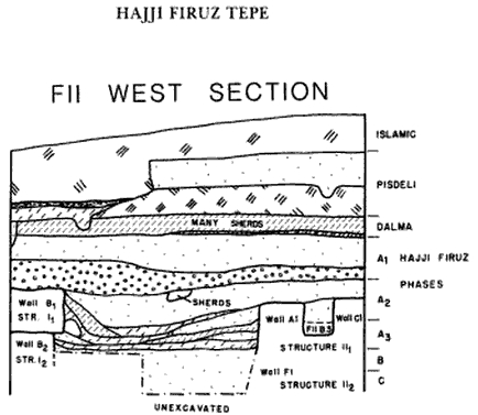
(3) Hasanlu V: The Late Bronze and Iron I Periods by Michael Danti The Ušnu-Solduz Valley and Lake Urmia region was extensively settled in the late Neolithic or Hasanlu Period X --- the Hajji Firuz Phase (see Voigt 1983). The beginning of the period may date to as early as the late 7th millennium BC and settled agricultural populations were well established in Ušnu-Solduz and in the area east of the lake in the 6th millennium (Burney 1964; Voigt 1983; Voigt and Dyson 1992:174). Various scholars have indicated this period is essentially a local variant of the Proto-Hassuna, Hassuna and possibly Samarran periods of northern Mesopotamia, citing similarities in ceramic assemblages and radiocarbon dates (Voigt and Dyson 1992:174). The Hasanlu Project excavated Hajji Firuz, the type-site for the period, in 1961 and 1968 and this archaeological culture has been documented at other sites by surveys (Voigt 1976, 1983; Young 1962) (3). The Chalcolithic is likewise well attested in Ušnu-Solduz and is divided into Hasanlu Period IX (Dalma Phase) and Hasanlu Period VIII (Pisdeli Phase). Dalma occupation was documented at the type-site of Dalma, excavated in 1961, as well as at Hajji Firuz, Pisdeli and at Hasanlu in the Well Sounding on the High Mound (Hamlin 1975; Voigt 1983:7-8, 17-18; Young 1962). Dalma represents a fairly widely distributed archaeological horizon in western Iran (Henrickson 1985, 1986; Kearton n.d.; Solecki and Solecki 1973) and exhibits strong affinities with and connections to the Ubaid archaeological horizon of northern Mesopotamia (Voigt and Dyson 1992:174-75). There is a smooth transition from Period IX to Period VIII. The Pisdeli Period is the local variant of the late Ubaid and early Uruk of Mesopotamia. Aside from the type-site of Pisdeli, which was sounded by the Hasanlu Project in 1961 (Dyson and Young 1960; Young 1962), Pisdeli occupations were documented at Hajji Firuz (Voigt 1983:8, 16-17) and in the Well Sounding at Hasanlu. As noted by Voigt and Dyson (l992:175), the depths of the excavated deposits at Hasanlu and Pisdeli indicate the period was quite long (ibid). Chapter III --- Results of the Excavations: The Haiji Firuz Settlement (Page 18) (2).
Following a long and continuous occupation by the Neolithic settlers the site was apparently abandoned for some time. When a new (Dalma) settlement was founded it was located on the central and western portions of the Neolithic mound. This area was occupied during the Pisdeli Period (and perhaps later), resulting in the formation of a high steep-sided mound with only a small flat area on its summit. During Bronze Age or early lron Age times mud brick structures were built in a new location adjacent to the eastern edge of the Neolithic and Chalcolithic mound; settlement continued in this area into the Islamic period. The northeastern portion of the Neolithic mound remained as a low open area throughout the later occupation of the site. Some soil accumulated above the Hajji Firuz deposit, presumably eroded from the central mound; however the main processes governing stratigraphy were soil removal and redeposition: from Dalma through Islamic times this area was used for a variety of activities, most of which seem to have involved digging holes. People dug small nondescript pits, large bell-shaped pits, burial pits and pits for industrial purposes. The result is chaotic. Later pits cut into earlier ones and removed the surfaces from which the latter had been dug: large chunks of the Hajji Firuz deposit were also carved away. Because of the amount of disturbance most of the post-Neolithic material from the main excavation area is not of great archaeological significance. The only definable living surfaces were in the Dalma and Pisdeli strata in square F11 and Trench F10 and Islamic deposits dated by radiocarbon and ceramics to the eleventh century AD. Chapter V --- The Sixth Millennium Environment (Page 272) The valley floor has been covered in the relatively recent past by a blanket of alluvium. Alluvial deposits dating to the late Quaternary period in the valleys and basins of northern and western Iran have been documented by Vita Finzi (1969). Two major deposits have been stratigraphically defined and archaeologically dated: the Tehran alluvium which was deposited between circa 50,000 years ago and the fourth millennium B.C.; and the Khorramabad alluvium which was deposited "largely if not wholly in the late Middle Ages" (Vita Finzi 1969:964). Although the total amount of alluvium deposited in the Gadar valley during the Quaternary is not known archaeological evidence indicates that there has been a rise in plain level of over one meter since the sixth millennium in the vicinity of Hajji Firuz Tepe. The earliest excavated structure at Hajji Firuz (XVIII) lies at a depth of 11.4 metres beneath the datum established on the summit of the mound; water accumulated in the excavation at this point so that the total depth of the archaeological deposit could not be determined. The present surface of the plain lies approximately 10.3 metres below the mound's summit. We can therefore infer a minimum rise in plain level of 1.1 metres since the early occupation of the settlement.
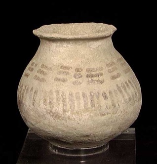
(4) Reconstructing Human-Landscape Interactions (Page 41-2) According to Vita-Finzi (1968) and supported by Krinsley (1970) there were 2 phases of alluvial deposition in Iran that were probably responsible for much of the basin and valley fill in the west and north. The earliest episode (the Tehran Alluvium) began no more than 50000 years ago and probably ended by the Fourth millennium BC (assigned a Late Pleistocene to Early Holocene age; Brookes 1989). This is generally a poorly sorted coarse consolidated alluvial deposit that ranges from silt and sand to pebble gravel and boulders (Krinsley 1970). After a period of erosion a second phase of deposition occurred between 900 and 1200 AD. Krinsley (1970) refers to this as the Khorramabad Alluvium which differs from the Tehran Alluvium by being mainly unconsolidated, finer-grained, better sorted and predominantly dark brown in colour. There is a distinct unconformity between the two and the later deposit is currently being eroded. Krinsley (1970) suggests that these 2 deposits are tentatively correlated with the Wurm Glacial and the Neoglacial respectively (4). The use of mud for the construction of settlements has resulted in the formation of artificial rises or mounds. These piles of cultural debris together with recent alluvium have obscured small natural rises on the plain. For example excavations at Agrab Tepe showed that this Iron Age site was built on a limestone outcrop (Muscarella 1973:47 Figure 1) and Baranu Tepe, an unexcavated settlement, was apparently founded on a sand and gravel ridge (see Appendix C). There is also some rather tenuous evidence which suggests that the village at Hajji Firuz was built on a low hillock or ridge (2). CLIMATE AND VEGETATION The climate and vegetation of the Ushnu-Solduz valley today are probably very different from those in the sixth millennium. In the first place human activities have changed the vegetation in Iran to the point where it is difficult to reconstruct the composition and distribution of natural ("climax") vegetation types (Bobek 1968:282). Second the postglacial vegetation in Iran was not at its optimum until the fourth millennium B.C. (Bobek 1968:293) following a stabilization in climate to approximately present conditions which occurred in western Iran sometime after circa 3500 B.C. (van Zeist 1967:310-311). If modern conditions were not established in western Iran until the fourth millennium B.C. what were the climate and vegetation like in the immediately preceding period? Both the Zeribar and Mirabad pollen cores indicate that during the period from approximately 8000 to 4000 B.C. (represented by pollen zone B) the central Zagros was covered by an oak-pistachio steppe forest which gradually thickened. After 4000 B.C. (pollen zone C) the Zagrosian oak forest which constitutes the climax vegetation of this area today was formed (van Zeist 1967:305 and 309 Figures 2-3). The palynological data from these two zones have been interpreted as indicating that the climate between circa 8000 and 4000 B.C. was drier than at present over most or all of western Iran (van Zeist 1969:43-44). Because many sites dating to the "driest" part of this period are located in areas which are at present marginal for dry farming of cereals, and because the inhabitants of these sites apparently relied on rainfall for the cultivation of cereals as well as other crops, van Zeist rejects the idea that "dryness" is to be equated with less precipitation per annum than at present. Instead he suggests that the growth of forests was inhibited by either a longer dry period or hotter summer temperatures. Such conditions would not affect the growth of cereals or other annuals which have completed their growth cycle before the onset of summer (van Zeist 1969:44; van Zeist et al 1975:140). Analyses of the populations of microfossils (Cladocera) present in the lacustrine deposits sampled by the cores "seem" to indicate that summer temperatures from circa 12,000 to 5,000 years ago were no warmer than at present (Megard 1967:188). The domestic plants represented at Hajji Firuz are among those commonly found at comtemporary sites in Greater Mesopotamia. One or more varieties of domesticated barley is present at nearly every agricultural site in this region (J. Renfrew 1969:Table 1; see also Bakhteyev and Yanushevich 1980:168-169; Harlan 1977:Table 2). Finds of lentil are more sporadic but this plant has been recovered from Çayönü (van Zeist 1972:11 Table 1) and it is well established at late sixth millennium sites such as Tepe Sabz (Sabz phase; Helbaek 1969:409), Choga Mami (Helbaek 1972b:40) and Hacilar (Helbaek 1970:224-225). Emmer wheat is so common at early agricultural and later sites that Helbaek considers it to be the "principal wheat of prehistoric and early historic times" (1970:207). Its tentative identification at Hajji Firuz is not surprising. Also conforming to a previously established pattern is the presence of bread wheat. Helbaek notes that while bread wheat has not been found at any of the early agricultural sites it "breaks out into the open in all finds of the early to mid-sixth millennium hitherto subjected to proper analysis" (1970:211; but see also Harlan 1977:364 and 367; van Zeist 1977:33-37). The animals that have been identified (Table 46) include a variety of small and large game, a few invertebrates and four domestic animals (sheep -- goat -- pig and dog). Only three species of small mammal are represented in the collection: hare -- badger and fox. The most common species of bird, the great bustard, is also the only one with a terrestrial habitat. Of the aquatic birds all but the heron and mallard are migratory species which were probably in Ushnu and Solduz during the late winter or spring. Large game animals represented in the sample include aurochs -- red deer and wild boar. The most commonly represented domesticated species are sheep and goat (Appendix G: Table 5). Survivorship curves suggest that very few caprines were killed before they reached circa 18 months and that more than half of the animals were fully mature when they died. While Meadow emphasizes the highly tentative nature of these data (see Appendix G) the pattern observed is "consistent with the use of caprines for meat while sustaining a viable breeding population" (Meadow 1975:277). Although three of the bones identified as Sus are so large that they must have come from wild boar the rest of the bone falls into ranges established for domestic pig. The survivorship curve, based on scanty data on epiphyseal fusion but supported by data on tooth eruption and wear, suggests that pigs were generally slaughtered when young (Appendix G). Again this is a pattern which might be expected in a domestic population (Meadow 1975:279-280). OTHER EVIDENCE FOR SUBSISTENCE ACTIVITIES The excavations at Hajji Firuz did not produce a single artifact that can be associated with the preparation of fields. Flint blades with sheen (CS-8) -- acceptable evidence for the harvesting of cereals -- are rare; it is probable however that some of the naturally shiny obsidian blades (CS-9) were used as sickle elements. Contrasting with the paucity of tools for the production of crops is the relative abundance of pottery vessels which were probably used for the storage of plant foods. The large jars or pithoi (Pottery FC-20) which were found set into house floors were almost certainly used for cereal storage. Smaller ceramic vessels were probably used for the storage of those kinds of plant foods which were kept in smaller quantities; for example pulses (Table 51). Site Distribution --- Survey Results The Hasanlu Project survey has recovered material dating to the Hajji Firuz period from the surface of five mounds: Hajji Firuz -- Baranu -- Tabiyeh East and Salman Tepes in Solduz and Gird-i-Allah in Ushnu (Figure 120). At two additional sites in Solduz, Dalma and Hasanlu Tepes, evidence of a Hajji Firuz occupation was found through excavation (Hamlin 1975:113; Dyson 1967:2952). With the exception of Hasanlu each of these mounds covers a relatively small area. It is however difficult to estimate the size of the Hajji Firuz settlements with any degree of accuracy since at each site there are later deposits. If we assume that the village at Hajji Firuz is "typical" then the average village in the sixth millennium probably covered an area of approximately one hectare. We can now summarize the available information on site distribution during the sixth millennium. Seven sites in the Ushnu-Solduz valley are known to have been occupied during the Hajji Firuz period. All these sites are mounds and presumably represent permanent village settlements similar to that at Hajji Firuz Tepe. The distribution of these sites is limited: with the exception of a single site adjacent to the River Gadar in the Ushnu valley the known sites occur in a pattern strung in a line which runs roughly east-west across the northeastern quadrant of Solduz. Although survey coverage and excavation were more intensive in this part of the valley than elsewhere the archaeological distribution should be representative of the actual distribution of sites on the valley floor with the exception of the meander belt of the river ... It seems likely that the resources which made this area so attractive to the sixth millennium settlers were the lakes and seasonally wet areas and associated vegetation types. The lake margins, the seasonally flooded land and the smaller marshy areas all support vegetation which remains green during the hot summer months when the rest of the plain and the lower parts of the hillsides are dry and dusty. The Hajji Firuz Subsistence Economy: A Reconstruction (Page 282) The floral and faunal remains recovered from Hajji Firuz Tepe indicate that the subsistence economy was based on the cultivation of cereals and pulses; the herding of sheep, goats and pigs; hunting and gathering; and perhaps fishing. The location of the known sites suggests that permanent water sources, seasonally flooded land and land with a high water table may have been important resources. The next step in reconstructing the subsistence system is to attempt to determine the techniques employed and their relative importance. Then inferences drawn will form the basis for speculation about land use patterns and the way in which the most important resources were exploited. Were it not for the existence of relatively capacious dry storage facilities the evidence for agriculture at Hajji Firuz Tepe would be tenuous at best. Because of the virtual absence of agricultural implements in the excavated area it might be argued that the grain recovered from the site was imported. This hypothesis is rejected here on the assumption that cereal cultivation was less laborious than the transportation of metric tons of food over long distances. The relative homogeneity of the environment within which all the known Hajji Firuz sites in Solduz are located makes it unlikely that these sites had specialized subsistence economies; if the grain recovered at Hajji Firuz Tepe was not produced locally and was not obtained through intravalley exchange then it would have had to come from a source outside the valley; that is from a distant source. A reliance on intervalley exchange for the procurement of a staple food which is easily produced is thus implausible. It seems preferable to assume that the Hajji Firuz villagers cultivated cereals but that their agricultural activities either did not involve the use of identifiable tools or that they employed tools which were not preserved archaeologically. The first factor which must be taken into account in any attempt to reconstruct the agricultural system at Hajji Firuz is the proposed identification of the bulk of the wheat recovered from this site as bread wheat. Helbaek has suggested that the establishment of bread wheat as a stable domesticate during the early to mid-sixth millennium depended on the use of controlled irrigation systems. The key to Helbaek's argument is the initial appearance of three cultigens -- flax, hexaploid wheat and six-row hulled barley -- in approximately contemporary contexts at Tepe Sabz and Tell Sawwan. He points out that flax could not be grown on the hot arid alluvial plains surrounding these sites without artificial watering; moreover the size of the flax seeds recovered indicates that they were grown under irrigation (Helbaek 1969:417-418; 1970:211-212). Direct evidence for the existence of controlled irrigation systems in the second half of the sixth millennium comes from Choga Mami where an irrigation canal has been excavated (Oates 1969:122-127). This site is intermediate geographically between Sabz and Sawwan and shows strong cultural ties with both of them. Large-seeded flax and bread wheat were found at Choga Mami but only one seed of hulled six-row barley was recovered (Helbaek 1972b:39). Because some of the earliest bread wheat (and hulled six-row barley) comes from these three sites where irrigation agriculture was evidently practiced and because all the finds known to Helbaek in 1972 came from sites near rivers (or in the case of Tepe Sabz a hypothetical river) he concluded that irrigation was necessary for the successful cultivation of these cereals (1969:421-423; 1970:212- 213; 1972b:39). Accordingly he contends that "controlled irrigation", that is dams, canals and/or drainage systems to manage water supplies must have been in use at all the sites where bread wheat and six-row hulled barley were found, including those which lie within the zone where rainfall farming was possible (Catal Huyuk and Hacilar) (Helbaek 1970:212-213, 240-241; 1972b:44-45). If the identification of bread wheat at Hajji Firuz is correct and if this crop was in fact grown in the vicinity of the site (rather than imported) then according to Helbaek's argument artificial water control must have been employed to grow it. There are several reasons for rejecting this hypothesis. First, Helbaek's reconstruction of the evolution and biological requirements of bread wheat are highly speculative and based entirely on the archaeological distribution of this form. There are however large geographical gaps in the archaeological record for the sixth millennium: at the time that Helbaek wrote the only plant remains available from the dry farming areas of Iraq, Iran and eastern Anatolia were a few seeds from Matarrah (see Renfrew 1969:Table I and compare with Oates 1973:Figure 1). More recently samples have been recovered from two additional sites -- Yarim Tepe I and Hajji Firuz Tepe. Second one might argue that the presence of bread wheat at Hacilar where "winter precipitation is extensive enough to allow cultivation of the whole of the rolling plain surrounding the village" (Helbaek 1972b:44) indicates that this crop could or might have been cultivated by dry farming. Moreover Helbaek himself originally concluded that uncontrolled flooding rather than controlled (canal) irrigation was used at Catal Huyuk (1964b:123). Finds of bread wheat at Yarim Tepe I and Hajji Firuz add to the roster of sites where irrigation may not have been required for the cultivation of bread wheat. To summarize bread wheat occurs at sixth millennium sites where rainfall cultivation is possible as well as at sites where irrigation is necessary. While it is feasible that early varieties of bread wheat did require "controlled" or artificial flooding to thrive this hydraulic technique must be inferred on the basis of evidence other than the archaeological distribution per se. A more positive argument for a broader definition of the ecological requirements of bread wheat may be proposed based on the Hajji Firuz settlement pattern. The location of the known Hajji Firuz sites in Solduz (well away from the river) and the pattern in which they are distributed (parallel to the river and across rather than along the predominant slope of the valley in this area) would appear to rule out the use of canals and river water for agricultural purposes. On the other hand these sites (as well as Gird-i-Allah in Ushnu) are located in a zone where other natural water resources are concentrated. We might return to Helbaek's first hypothesis about bread wheat cultivation and suggest that the areas subject to natural or uncontrolled flooding (the seasonally flooded land and/or the seasonal marshes) were used for the cultivation of bread wheat by the Hajji Firuz farmers. Alternatively we might choose another aspect of the environment as critical for agriculture: it is possible that the relatively high water table in the settled areas provided sufficient moisture for bread wheat and for reliable yields of other crops as well. Flannery (1969:81) has hypothesized that the early dry farmers consistently selected land with a high subsurface water table, using soil moisture to balance out fluctuations in precipitation and reduce the risk of crop failure. Even if we assume that the average annual precipitation in Ushnu and Solduz during the sixth millennium was circa 300 mm, well above the minimum needed for cereal cultivation, variation in the total amount of precipitation as well as its distribution during the growing season may have led to the selection of those areas where soil moisture content was relatively high. If cultivation was carried out on seasonally flooded land, either the mud flats in northeastern Solduz or the Gadar floodplain, the technology required would have been simple. The seed could have been broadcast and either left on the surface or perhaps poked into the mud, thus giving some protection against birds and rodents. According to Zeuner both the ancient Egyptians and the Greeks used pigs to "tread in the seed after floods or rain; with its somewhat pointed feet [the pig] made holes of the right depth suitable for germination" (1963:264). Presumably a herd of sheep or goats would have served the same purpose. The chief disadvantage of such a system is the potential loss of seed to the animals, a problem which the ancient farmers solved by muzzling their pigs (Zeuner 1963:264). Alternatively a wooden digging stick could have been used to poke the seed beneath the surface, a suggestion made by Smith and Young (1972:44). It is always difficult to assess the relative importance of plant foods as opposed to animal foods among prehistoric groups. In the case of Hajji Firuz Tepe however it may be possible to use the capacity of dry storage facilities in residential structures to estimate the contribution of the staple cultivated plants to the diet of the average household. During the latter part of the occupation (Phases E through A) large storage jars were apparently located in each house (Table 47). These jars or pithoi were usually set into pits cut into the house floor. The form, matte surface finish, size and location of these jars suggest that they were used to store plant food. Given the kinds of seeds recovered at the site, it seems highly likely that the jars were used for cereals or for a combination of cereals and pulses. Evidence for gathering activities is scanty. Only a few remains of eggs, reptiles, invertebrates, fish and wild food plants were recovered and none of the Hajji Firuz artifacts can be associated directly with the exploitation of such resources. On the basis of the data available we must conclude that gathering activities with the possible exception of the collection of wild pulses and/or land snails, were sporadic. There is no evidence that such wild foods were obtained from areas beyond the valley floor or perhaps the hillsides near the settled areas. The most important kinds of animal food were the meat of wild and domesticated artiodactyls and probably the milk of domesticated caprines. Although the faunal sample is small it provides some information on the relative importance of wild and domesticated animals as meat sources and therefore on the relative importance of hunting and herding as subsistence strategies. Small game animals are poorly represented in the excavated sample, suggesting that they were not systematically exploited. Large game animals (aurochs -- red deer -- wild pig) were more numerous. Depending on the method by which meat yields are calculated their contribution was approximately one-quarter to over one-half the total amount of meat represented in the sample (Meadow 1975:282). Even if we accept the minimum estimate of meat yields from large game animals it is clear that aurochs -- red deer and wild pig contributed a large amount of meat (Table 50); they were however eaten with far less frequency than the domesticated species (Appendix G: Page 401). The excavated sample therefore indicates that large game animals provided occasional gorges in a more regular (and regulated) diet of domesticated animals. On this basis alone we might infer that herding was more important than hunting and the significance of herding would be even greater if caprines were used to provide additional calories in the form of milk. The small number of game animals recovered suggests that hunting was a relatively infrequent activity; it was however undertaken with some regularity: wild animal bones were recovered from all chronological units excavated in 1968 and from all the excavated areas of the Hajji Firuz settlement (see Meadow 1975: Table 1). Birds and mammals were presumably hunted with bow and arrow, perhaps with the aid of dogs. The hunters need not have travelled any great distance in pursuit of their quarry. Water birds could have been obtained from the lake shores or along the Gadar. Meadow (1975:282) has suggested that the large artiodactyls (aurochs -- red deer -- wild boar) might have been hunted in the grain fields or near permanent water sources during the dry season; however these animals would also have been available across the uncultivated grasslands which must have covered most of the valley floor. Pastoral activities can be divided into two groups: those required for the exploitation of pigs and those required for the exploitation of caprines. Pig raising requires a variable amount of labor depending on the specific techniques employed. Because of their ability to ingest nearly anything pigs are generally able to forage for themselves and most systems of pig raising take advantage of this fact. If however the animals are to be kept from going feral, some sort of "management" must be imposed, either through human control of the food supply or human control of the movements of the animals Second, pastoral products supplied nutrients which were present only in small quantities in the staple crops. Most of the fat in the diet must have been obtained from the meat of domesticates, especially pork (Table 49). Milk was also a potential source of fat but this food would have been most valuable as a source of calcium and vitamin A. The only foods represented in the excavated sample from Hajji Firuz Tepe which would have had a similar calcium content are wild pulses (see Flannery 1969:Table 3) and there is no evidence from the site which suggests that these plants were consumed in large quantities. Lentils were probably cultivated and would have been a good source of vitamin A as well as a minor source of calcium (Flannery 1969:Table 3). To summarize, during the latter half of the sixth millennium the Ushnu-Solduz valley was occupied by groups which cultivated wheat and barley and herded sheep -- goats and pigs. They sometimes hunted and occasionally brought down large herbivores; however the bulk of their food supply was derived from domesticated plants and animals. They apparently used relatively simple techniques for cultivation and relied on precipitation and perhaps land with a high subsurface water table to provide sufficient moisture for cereal growth. Because of variations in the amount and timing of precipitation in this part of the Zagros there may have been a significant risk of crop failure. Pastoralism provided a hedge against serious food shortages caused by drought and a means of scheduling the utilization of food sources to avoid minor (seasonal) shortages. The Gadar River valley offered certain resources including freshwater lakes, extensive tracts of reed marsh and summer green vegetation on the valley bottom which were probably unusual in this part of the Zagros. The exploitation of these resources as pasture and water sources for herds of domestic animals would have made it possible to maintain at least some animals in the valley year round. The Hajji Firuz villagers would therefore have been able to rely heavily on their herds as a food source while expending a minimal amount of labor in their care. Chapter VI --- Cultural and Economic Diversification in the Sixth Millennium (Page 322) The village of Hajji Firuz was occupied in the latter half of the sixth millennium by a group of farmers and herders who lived in similar houses and performed similar activities. It can be characterized as an egalitarian society made up of self-sufficient households and as such can provide an archaeological baseline for the study of more complexly organized settlements. It is undoubtedly similar in organization to the earlier (seventh millennium) villages in the Zagros mountains; however the economy at Hajji Firuz differs from that of earlier villages in that it is one of several new types of agricultural systems which evolved within northern and central Mesopotamia and the northern Zagros during the sixth millennium. The economy of the early dry farmers in this area, documented at central Zagros sites such as Tepe Guran -- Tepe Sarab -- Jarmo and at Ali Kosh, a related site on the edge of the Khuzistan plain, has been well described by Flannery (1969:79-88; see also Sherratt 1980). The subsistence systems at these village sites included a strong emphasis on hunting and gathering as well as on cereal cultivation and caprine herding. The nature of the relationship between the early Zagros villages and the earliest known sites on the northern Mesopotamian plain is not clear. Using more or less the same data some archaeologists have stressed the parallels between Zagros and early Hassuna sites and proposed a lineal relationship between them while others have stressed differences between assemblages and rejected a Zagros origin for Hassuna (compare Braidwood and Howe 1960:161, Plate 15:18 with Mortensen 1964a:34-36). It is unlikely that any consensus will be reached until key sites such as Jarmo -- Umm Dabaghiyah -- Tell es-Sotto -- Yarim Tepe I and Cayonu have been fully published and there has been some archaeological investigation of the area along the northeastern and northern borders of Iraq. But whatever the ultimate solution to this problem of origins there is little doubt that by the second half of the sixth millennium Hassuna villages differed significantly from the early Zagros villages in their economy. Groups with a material culture similar to that found at Hajji Firuz Tepe appear to be distributed widely within the Urmia basin. Yanik Tepe, located on the eastern side of Lake Urmia, has produced similar pottery, chipped stone tools and bone artifacts as well as similar architecture (Burney 1964) and potsherds similar to those from Hajji Firuz have been found on a site in the Salmas valley to the northwest of the lake (Kearton 1969; 1970:122-124, Figures 27-28). We can therefore speak of a Hajji Firuz tradition in northwestern Iran which is contemporary with two traditions in northern Mesopotamia -- Hassuna and Samarra -- but which has a contrasting type of economy. But the subsistence system at Hajji Firuz is not just a late example of the type of system practiced by the early Zagros farmers: it is specifically adapted to resources in Solduz and probably involved a greater dependence on herding than in the seventh millennium. Even more significant is the fact that the Hajji Firuz settlers who migrated into the Gadar valley (and presumably the rest of the Urmia basin) in the first half of the sixth millennium were apparently closely related to the early Hassuna groups. The ceramic parallels between Hajji Firuz and early Hassuna sites are numerous and specific; however the Hajji Firuz material used to establish these parallels was manufactured more than a half a millennium later than the early Hassuna pottery. The most reasonable interpretation of the data available at present is that the group which colonized Ushnu and Solduz was closely related to early Hassuna groups, perhaps the settlers on the Mesopotamian plain or Hassuna groups in the uplands which lie between northern Mesopotamia and the Urmia basin. If this interpretation is valid then the Hajji Firuz villagers were clearly a conservative group that chose to move into an area that would require only minor changes in their subsistence pattern rather than the major changes required of the early Samarra groups. The change toward a more intensive subsistence system and a more complex type of economic (and consequently social and political) organization on the Mesopotamian plain is usually emphasized because of its importance to the evolution of politically and economically differentiated societies in this region. Sites such as Hajji Firuz however document the diverse kinds of new adaptation which characterize the sixth millennium in Greater Mesopotamia and provide an example of the variety of life styles which were evolved as groups colonized new areas and exploited new resources. Chapter IV Artifacts --- Introduction (Page 95) An attempt has been made to compare each class of artifacts with artifacts from other sites which date to the seventh or sixth millennium and which are located within neighboring geographical regions: the northern and central Zagros -- northern Mesopotamia and the Iranian plateau. This geographical coverage was broadened in the case of certain artifacts known to have been traded over long distances (for example some types of chipped and ground stone tools). Long distance parallels have also been documented when the artifacts in question are unusual as well as closely similar (for example scapula scrapers). In the discussion which follows the material from one site is considered to be the product of a group which shared the same general body of traditions as the group at Hajji Firuz Tepe. The assemblage from the "Late Neolithic" strata at Yanik Tepe located just to the east of Lake Urmia is very similar to that from Hajji Firuz in architecture -- pottery -- bone tools and (to a lesser degree) chipped stone tools (Burney 1964; Burney and Lang 1972). The cultural unit to which both can be assigned is referred to here (with a blatant lack of objectivity) as the "Hajji Firuz culture". The purpose of the excavation in 1961 was to establish the stratigraphic position of the Hajji Firuz assemblage as one of a series of qualitatively defined assemblages constituting the archaeological sequence in the Ushnu-Solduz valley. The Hajji Firuz material was viewed as a unit which was to be differentiated by means of stratigraphy and a set of distinctive artifact types from the succeeding Dalma material; variation with the Hajji Firuz assemblage was of minor importance. In 1968 one of the major goals was to obtain information on the kinds of activities involving ceramic vessels carried out at the site and if possible on the location of such activities within the settlement. The Hajji Firuz pottery is handmade and vegetable tempered. The paste is filled with impressions made when the chopped bits of chaff or wild grasses mixed. with the clay burnt out during firing. Usually grit inclusions are also visible in the vessel wall. In general, as the size of the vessel decreases the paste becomes finer in texture and the size of the grit inclusions decreases. Comparison with Other Ceramic Industries Comparison of the Hajji Firuz pottery with that from sixth and seventh millennium sites in adjacent regions is difficult because of the preliminary nature of the published descriptions of the ceramic industries of key sites. The discussion which follows is based on published information taken in conjunction with a study of relevant collections of sherds and vessels. THE NORTHERN AND CENTRAL ZAGROS During the seventh and sixth millennia this area was occupied by groups of farmers and herders who shared a distinctive tradition encompassing many aspects of material culture including ceramic technology and style. The best known sites within this tradition (referred to as the Zagros group) are Qalat Jarmo in northern Iraq and two sites in west-central Iran: Tepe Sarab located in the Kermanshah valley and Tepe Guran in the Hulailan valley (see Mortensen 1964a; Oates 1973:158-159). A deep sounding at Tepe Guran produced a well defined stratigraphic sequence spanning most of the seventh and the first half of the sixth millennium (Mortensen 1964b). Eighteen Neolithic occupation levels were distinguished, the first three of which (V-T) were aceramic. Mortensen's analysis of the pottery from the succeeding levels (S-D) shows change within the ceramic industry and provides a means of ordering other Zagros group sites in time. (See Mortensen 1964b: 113- 118 for type descriptions of the Guran pottery. These types can also be applied to the Sarab and Jarmo industries). The pottery which is usually considered characteristic of the Zagros group sites is that classified as Undecorated Buff Ware and Standard Painted Ware (with Jarmo-- Sarab and Guran variants); these "Zagros standard" wares predominate in the middle and upper levels at Guran (Mortensen 1964a:30-33 and Figure 7) as well as in the earlier of two components at Tepe Sarab and the early portion of the pottery-bearing deposit at Jarmo (see below). There are some general similarities between this material and the (later) pottery recovered from Hajji Firuz Tepe: shared characteristics include the use of chopped vegetable matter as a tempering agent, a relatively soft paste, burnished (as well as wet-smoothed) surfaces, light surface layers with gray cores, the use of a fugitive red paint and the use of geometric designs. There are however many differences between the Hajji Firuz pottery and Zagros standard pottery as represented in the collections from Guran and Sarab. Although there is some overlap between assemblages Zagros standard pottery usually has a finer vegetable temper than Hajji Firuz pottery; lime inclusions which may have been added to the paste as temper are rare in Hajji Firuz vessels but relatively common in Zagros standard vessels. Most of the pottery from Sarab and Guran is more completely oxidized than the Hajji Firuz pottery: Zagros standard sherds which have been fired to orange or buff throughout are common; when gray or unoxidized cores are present they are thin and relatively light in color. Friability is a rather subjective characteristic but my impression is that Zagros standard pottery is more crumbly than Hajji Firuz pottery and breaks into smaller pieces. Stylistically the large-scale linear designs painted on Hajji Firuz vessels contrast strongly with the dense overall designs (usually composed of geometric elements arranged along oblique lines) and the bands of negative lozenges or zigzags characteristic of Zagros Standard Painted Wares (see Mortensen 1964b:Figures 16-18; 1974a:Figure 7). Some simple bowl forms are shared by Hajji Firuz and Zagros group sites but there are major differences in the total range of forms. Particularly striking are: 1) differences in the profiles of carinated bowls, perhaps the result of different methods of vessel wall construction; and 2) the absence or rarity of necked vessels at Zagros group sites (see Braidwood and Howe 1960:Plate 15; Mortensen 1964b:Figure 16). The size range also varies: very large vessels similar in capacity to the large bowls and jars common at Hajji Firuz are apparently absent from the early deposit at Sarab and the middle levels at Guran. Globular storage jars with diameters as great as 60 cm were found at Jarmo (Matson 1960:64) but they are probably associated with the later pottery from the site rather than the early or Zagros standard pottery (see below and Braidwood and Howe 1960:44). There are few good ceramic parallels between Hajji Firuz Tepe and contemporary Late Neolithic or Early Chalcolithic occupations in Hulailan [Valley] but this might be expected given a divergence during the sixth millennium between the pottery of Guran and that from Tepe Sarab, located only 60 kilometres to the north in the Kermanshah valley. The separation of the material from Sarab into two components, one contemporary with the excavated strata at Hajji Firuz and one which predates Hajji Firuz, helps to clarify the relationship between these sites (see Dyson 1965a:217-218; Young 1962:707; Smith and Young 1972 with references). The collection of sherds from Sarab in the Royal Ontario Museum includes a small number which are similar to the Hajji Firuz painted pottery in technological as well as stylistic attributes. It is now apparent that these sherds are not anomalies within a Zagros Standard ceramic industry but are ordinary examples of Sarab Linear Ware derived from the later component at Sarab. Like the Hajji Firuz pottery Sarab Linear Ware has a coarser vegetable temper than Zagros Standard Painted Ware; vessel walls are thick and usually have a gray core. Among the most common Sarab Linear motifs are two which frequently occur at Hajji Firuz: nested chevrons, sometimes pendant from annular bands, and nested zigzags. The way in which motifs are arranged on the vessels also appears similar. Sarab Linear vessels are usually baglike but carinated forms also occur (Levine and McDonald 1977:40). I have examined only a few sherds from Jarmo but one of these, a body sherd decorated with a series of red-painted parallel lines, was indistinguishable from a typical Hajji Firuz painted sherd when the two were placed side by side. Without knowledge of the Jarmo ceramic industry as a whole and the degree to which this sherd is representative of the later group of vessels from the site, it is not possible to determine whether the identity of physical characteristics observed indicates exchange between the group at Jarmo and some Hajji Firuz community or a closer relationship between Jarmo and Hajji Firuz. The possibility of a shared ceramic tradition should be considered but there are significant differences in style (particularly vessel forms) between the Hajji Firuz and the late Jarmo ceramic industries. Whatever the nature of the relationship, contemporaneity of some portions of the excavated deposits at these sites is certainly implied and a date as late as circa 5500 B.C. is suggested for the latest material at Jarmo. Although many aspects of the relationship between Hajji Firuz and Zagros group communities remain obscure some general conclusions can be drawn. The pottery from Hajji Firuz and from Zagros group sites dating to the late seventh and early sixth millennium is similar with respect to broad technological characteristics; these similarities probably reflect a common origin within a widespread tradition of pottery manufacture rather than any close relationship between Zagros group societies and the people who migrated into the Urmia basin shortly after 6000 B.C. During the sixth millennium contemporary with the development of the Hajji Firuz ceramic tradition, distinct regional styles evolved within the previously homogeneous Zagros group tradition. Both technological and stylistic parallels can be drawn between the Hajji Firuz pottery and that from late Zagros group occupations in northern Iraq and the Kermanshah-Mahidasht valley. The archaeological significance of these parallels and the degree to which they reflect direct contacts between the groups living in the Urmia basin and in parts of the Zagros to the west and south cannot be determined until more is known about the origins of Late Neolithic painted wares at sites such as Sarab and Jarmo. It is possible that some or all the observed similarities in painting style result from independent contacts or relationships between mountain populations and adjacent Hassuna or Samarra settlements in Mesopotamia (see below; Braidwood and Howe 1960:44; Levine and McDonald 1977:44). Such a pattern would be consistent with the establishment of strong ties between the southernmost Zagros group settlements (in Hulailan) and communities in Khuzistan during the second half of the sixth millennium. MESOPOTAMIA Technologically the Hajji Firuz pottery seems to be most similar to that recovered from early Hassuna settlements such as Umm Dabaghiyah -- Tell es-Sotto and Telul eth-Thalathat (Levels XVI and XV).
The Undecorated Coarse Ware from Shimshara, a Samarran site located in the Zagros, is similar in paste composition and texture to the vegetable-tempered pottery from related lowland sites but it is closer to the Hajji Firuz pottery in color and perhaps in method of firing. The major differences between this Shimshara ceramic type and the Hajji Firuz pottery are: 1) Shimshara Underrated Coarse Ware is always wet-smoothed and never burnished or painted (Mortensen 1970b: 104); 2) it is apparently somewhat harder than similarly finished Hajji Firuz pottery; and 3) the Shimshara Underrated Coarse Ware vessels are much more crudely modelled and finished than most Hajji Firuz vessels. The pattern of relationships between Hajji Firuz and sixth millennium Mesopotamian ceramic industries suggested by a comparison of technological attributes is repeated when stylistic attributes are compared. The best parallels in vessel form and decoration are again with early Hassuna sites, particularly Umm Dabghiyah (Kirkbride 1972:Plates X-XII; 1973a:Plates 11:12-18) (B). (B) The stylistic parallels between Hajji Firuz and Umm Dabaghiyah are so numerous and so obvious that complete documentation in the form of vessel by vessel comparisons seem unnecessary pending the final report on Umm Dabaghiyah. Most of the bowl forms found at Hajji Firuz occur at Umm Dabaghiyah; moreover the carinated profile which is so characteristic of Hajji Firuz also dominates at both Umm Dabaghiyah and Telul eth-Thalathat (Kirkbride 1972:9; Fukai et al 1970:Plates LXXIX:13-14 and LXXX:6-7). Necked vessels were apparently not made by the early Hassuna potters but storage vessels with profiles typical of the Hajji Firuz pithoi (form 20) have been found at both Umm Dabaghiyah and Telul eth-Thalathat. The Umm Dabaghiyah jars are relatively small (up to 50 cm in height) but those from Telul eth-Thalathat have a size range similar to the Hajji Firuz form 20 jars (Fukai et al 1970:Plate LXXX:1 and 3-5; Kirkbride 1972:Plates XIV:a-c). The only other major difference in vessel form is the presence of oval vessels at the earlier sites (Fukai et al 1970:Plate LXXIX:11; Kirkbride 1973a:Plates II:17 and III:10). The painted pottery from Umm Dabaghiyah is similar to that from Hajji Firuz in the motifs used and in the way that design elements were placed on vessels (Kirkbride 1972:Plate X; 1973a:Plate III:9-13). Motifs found at both sites include annular bands (usually at the rim) -- vertical lines -- nested chevrons -- dots and solid triangles. Dots (which are rare at Hajji Firuz) and other curvilinear elements not found at Hajji Firuz occur only in the early part of the deposit at Umm Dabaghiyah (Kirkbride 1972:9-10). The only kind of plastic treatment of the surface which was used at both Hajji Firuz and early Hassuna sites is impression, restricted to the bottoms of husking trays; the finger impressions at Umm Dabaghiyah appear to be more shallow and widely spaced than those at Hajji Firuz (Kirkbride 1973a:Plates II:14 and X:c). A much smaller number of stylistic parallels can be drawn between Hajji Firuz and Tell Hassuna and most occur in the early part of the Hassuna sequence. The jar forms used for Hassuna Coarse Ware include collared carinated shapes with proportions similar to those of the Hajji Firuz collared jars (forms 18 and 19) as well as the neckless variant found at earlier Hassuna sites (Lloyd and Safar 1945:Figures 6:1-3 and 7 and 10-11 and 14; Plates XII 2:a -- XIII1:a and c). It is difficult to compare the Hassuna bowl forms with those from other sites because of a lack of information on vessel size and (consequently) proportions; few complete profiles have been documented and the diameters are not given for vessels represented only by sherds. Two precise parallels can be cited: a small Coarse Ware cup from Level Ia duplicates a common form at Hajji Firuz (Figures 73s; Lloyd and Safar 1945:Plate XII:1:b) and the husking trays from Hassuna and Hajji Firuz have the same types of basal impressions as well as similar profiles (Figures 80e -- 81 and Plate 20; Lloyd and Safar 1945: Figure 3:8-10 and PIate XVIII:1). There is probably a significant overlap in the range of bowl forms used at the two sites but the frequency of specific forms appears to be quite different. In general rounded and/or shallow forms seem to have been preferred for Hassuna Archaic and Standard Ware bowls while deeper more angular forms predominated at Hajji Firuz (see Table 23; Lloyd and Safar 1945:Plates XIV and XVI). The Samarra Ware bowls from Tell Hassuna often have carinated or S-curved walls but they are shallower than the majority of the Hajji Firuz bowls with similar profiles (Lloyd and Safar 1945:Plate XVII). All the grit-tempered jars from Hassuna have globular bodies (Lloyd and Safar 1945:Figures 2:1-6 and 3:1-2 and 4 and 6 and Plate XV; see also Merpert and Munchaev 1973:Plate XLI). With the exception of a few thickened and everted rims on Hassuna Archaic bowls (Lloyd and Safar 1945:Figures 7:21-27 and 8:3 and 5-6 and 9-12) the same simple rim forms were used at Hassuna and Hajji Firuz. Base forms are poorly represented at Hassuna but forms similar to those at Hajji Firuz were used for Matarrah Coarse Simple Ware (Smith 1952: Figure 10:16-22). To summarize, a comparison of the Hajji Firuz ceramic industry with those from early settlements in northern and central Mesopotamia suggests a series of relationships which follow a coherent chronological and geographical pattern. The pottery which is most similar in both style and technology to the Hajji Firuz material, including that from the latest excavated phases, comes not from contemporary Hassuna and Samarra settlements but from sites assigned to the early Hassuna period. The degree of similarity is such that the Hajji Firuz and early Hassuna ceramics can be considered products of a single broadly defined tradition of manufacture and decoration. The best reconstruction which can be offered at present is as follows: Shortly after 6000 B.C. groups of sedentary cultivators and herders moved into the Ushnu-Solduz valley, a previously unoccupied region. The ceramic evidence suggests that they emigrated from an area where they were in relatively close contact with early Hassuna groups or perhaps the populations ancestral to early Hassuna groups. The migration into the Urmia basin did not put an end to the exchange of ideas between the Hajji Firuz and Hassuna potters: designs similar and in one case identical to those recovered from Hajji Firuz Tepe occur on Archaic Painted pottery from Levels I and II at Tell Hassuna; strata with Archaic Painted wares at Yarim Tepe I have been dated to circa 5400-5300 B.C. (Merpert et al 1976:34 and 43; C14 dates corrected to 5730). Nevertheless the primary trend during the second half of the sixth millennium was a divergence among ceramic industries, both in technology and in style. The only evidence of direct contact between late Hajji Firuz and Mesopotamian groups is in the form of rare imported vessels (Pages 98-99 and 101-102). Most other parallels are between heavy cooking and storage vessels, types which changed little throughout the sixth millennium. The one site which may provide evidence of closer ties between Hajji Firuz and settlements to the west at the end of the sixth millennium is Shimshara, the only well known Samarran site in the mountains. The way in which this divergence came about is clear. The rate of change in ceramic industries in Mesopotamia differed radically from that in Solduz; whereas there were significant technological changes and concomitant shifts in style in Hassuna and Samarra industries, there was stability throughout the sequence at Hajji Firuz Tepe. The cultural processes which resulted in adherence to existing norms of behavior or in change cannot be fully specified but one variable which must have played an important role was the organization of ceramic production. Within the village of Hajji Firuz pottery was apparently made by women to fill the needs of their own households. A similar pattern may have existed in early Hassuna settlements; however by circa 5400 B.C. there is evidence that large-scale ceramic production, presumably carried out by specialists, had begun at Hassuna sites. This evidence is in the form of two-stage kilns, facilities which are unlikely to have been evolved or built in order to satisfy the limited needs of a single domestic unit (see also Oates and Oates 1976b:42-43). Such kilns occur as early as Level I at Yarim Tepe I where they are associated with Hassuna Archaic Ware (Merpert et al 1978:28 and 32-34). During the period when Hassuna Standard and Samarra wares were being produced the evidence for specialized craftsmen is stronger. In Level IV at Yarim Tepe I there was an area of the settlement set aside for pottery manufacture; it contained at least 13 domed kilns up to 2.0 metres in diameter, burnt pits which may have been used as bonfire kilns and wasters (Merpert and Munchaev 1973:96, Plate XXXVI. According to the excavators "not all of the kilns were in use at the same time but their arrangement in groups, sometimes marked off by boundary walls, suggests that this was an established industrial quarter . . ." (Merpert and Munchaev 1973:96). The presence of motifs interpreted as potters' marks and the general high quality and widespread distribution of Samarra ware long ago led to the interpretation of this pottery as the product of specialists (Braidwood 1945:258-259). Recently very large "vaulted" features interpreted as pottery kilns have been found at Tell es-Sawwan (Merpert and Munchaev 1973: 102, n. 27). THE IRANIAN PLATEAU The pottery from Yanik Tepe is much like that from Hajji Firuz Tepe in form and decoration and the published description of technological characteristics also indicates a lack of significant differences between sites (Burney 1964:56 and 60). There is however some stylistic variation. A small number of trade sherds and similarities between many nonceramic artifact types provide evidence of contact among the Ushnu-Solduz valley and areas in and across the mountains to the west. There are few ties to the south or east. Contact between groups in the Mahi Dasht and central Mesopotamia during the latter part of the sixth millennium has also been suggested (Page 163 above; Levine and McDonald 1977:44). But the Mahi Dasht is also linked to sites in the east. We thus have a chain of sites which stretches from central Mesopotamia through the Mahi Dasht to the central part of the Plateau. One plausible explanation of this pattern is that the east-west route known in later times as the Great Khorasan Road was in use by circa 5500 B.C. Movement from central Iran to the area around Tabriz is relatively easy. It is therefore likely that outside the Urmia basin the strongest ties of a settlement such as Yanik Tepe would be with groups to the southeast.
(1) The Origins and Ancient History of Wine: Neolithic Period -- "Chateau Hajji Firuz"
(2) Hajji Firuz Tepe Iran: The Neolithic Settlement --- Hasanlu Excavation Reports: Volume I
(3) Hasanlu V: The Late Bronze and Iron I Periods by Michael Danti (University of Pennsylvania Press) 2013
(4) Reconstructing Human-Landscape Interactions by Lucy Wilson -- Pam Dickinson -- Jason Jeandron (2009)
|