|
Other Archaeological Sites / The Neolithic of the Levant (500 Page Book Online) Ancient Mari (Tell Hariri) ProofRead and Updated June 11th 2019 See: Mari in Syria --- WikiPedia
Read the Mari Page from the Encyclopedia Judaica Second Edition -- Volume 13 (2007) Ancient city of Mesopotamia. It is on the middle Euphrates south of its junction with the Khabur. The site was discovered by chance in the early 1930s by Arabs digging graves and has subsequently been excavated by the French. The earliest evidence of habitation goes back to the Jemdet Nasr Period in the 3rd millennium BC and Mari remained prosperous throughout the Early Dynastic Period. The temple of Ishtar and other works of art show that Mari was at this time an artistic center with a highly developed style of its own. As the commercial and political focus of West Asia circa 1800 BC its power extended over 300 miles from the frontiers of Babylon proper up the Euphrates to the border of Syria. The inhabitants were referred to as Amorites in the Old Testament and spoke a language related to the Hebrew of the patriarchs. The archives of the great King Zimri-Lim, a contemporary of Hammurabi in the 18th century BC, were discovered in 1937. They contain over 20000 clay cuneiform documents which have made it possible to fix the dates of events in Mesopotamia in the 2nd millennium BC. Also found at Mari is the great palace complex of Zimri-Lim consisting of more than 200 rooms and covering 5 acres (2 hectares). Hammurabi conquered Mari circa 1700 BC and Babylon then became the center of West Asia. Mari never regained its former status ... Mari : capital of northern Mesopotamia in the third millennium BC : the archaeology of Tell Hariri on the Euphrates by Jean-Claude Margueron (2014)
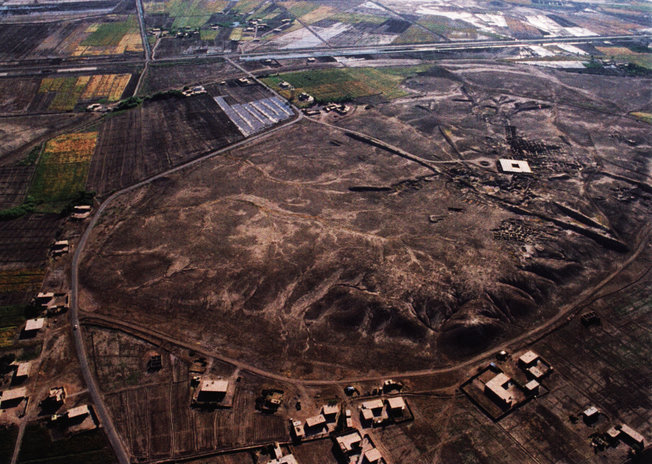
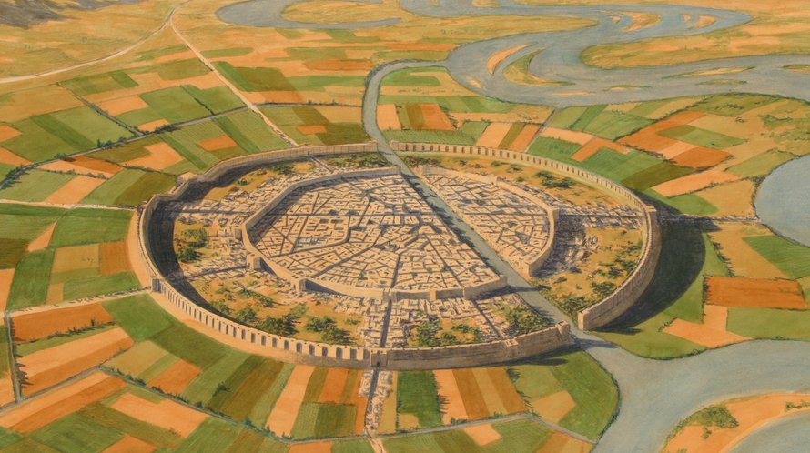
IMAGINING MARI: Jean-Claude Margueron and the Archaeology of Tell Hariri Just north of the Iraqi border in eastern Syria lies Tell Hariri, a half-circle shaped tell [mound] situated between the modern road and the Euphrates River. This ancient tell is the city of Mari, rediscovered in August of 1933 when locals accidentally recovered a massive fragmentary statue of a male figure wearing a mountain patterned kilt. During the six years preceding the Second World War (and a halt in archaeological work) French excavations at Tell Hariri directed by André Parrot unearthed important structures and sensational finds that made Mari one of the best-recognized cities of the ancient world. On the western edge of the tell the temple of Ishtar yielded gypsum votive statuary of a type already known from several Early Dynastic period Mesopotamian sites, including an inscribed example that gave the ancient name of the city. To the east the “Great Royal Palace” of the early second millennium B.C.E. was excavated along with several religious monuments of the same period -- the “temple of Lions” named after the bronze cast protomes of two lions found therein; and the “High Terrace” -- a large structure that Parrot associated with Mesopotamian ziggurats ... Thousands of cuneiform tablets were found also in the palace and have been assiduously published and interpreted by successive teams of experts over the intervening years. These tablets -- mostly administrative texts and letters dated to the early second millennium B.C.E. -- have helped reconstruct the political history of the period; shed light on the social history of tribes -- women -- artisans and other palace constituents; and provided Biblical scholars comparanda for vocabulary and social phenomena (such as prophecy) otherwise rarely attested in cuneiform writing. Mari is the most comprehensive English-language treatment of the city to date, offering a narrative of the city’s millennium-long history (circa 2950–1760 B.C.E.) based on Margueron’s thirty-five year research program. Richly illustrated with 180 figures and written for a broad audience, Mari is the kind of exemplary volume that will be of interest to ancient Near Eastern specialists and students -- educators and scholars researching ancient architecture or urban planning.
In Chapter I Margueron explains the foundation of Mari in circa 2950 B.C.E. -- at a site located in a region ill-suited for agriculture and near a river known for annual flooding -- as the result of a desire to control trade between the mineral-rich mountainous north and the cities of the south. Chapter II builds the argument that Mari was from the beginning a carefully planned urban center with circular walls and extensive hydraulic works. Margueron suggests that the city’s location -- 2 km away from the ancient course of the Euphrates -- was selected to mitigate the destructive effects of flooding. Circular walls, later used defensively, were built to divert floodwaters. Margueron reasons that the perfectly circular walls could only have been designed on a flat (unbuilt) surface. Aerial photographs and a survey conducted by Bernard Geyer revealed traces of a canal near the modern tell. This “linking” canal would have bisected the city and connected it to the Euphrates, providing necessary access to water.
Chapter III: The identification of City I (circa 2950–2650 B.C.E.) is one of the achievements of the excavations but little is known about this phase and major institutions have yet to be identified. City II (circa 2550–2220 B.C.E.), built following a possible period of abandonment, is archaeologically the best-preserved phase. Palace -- temples and dwellings of this phase show traces of being destroyed by fire. Margueron identifies this systematic destruction with the Akkadian ruler Naram-Sin but others suggest the destruction should date to his predecessor Sargon (Charpin 2005; Bretschneider -- Van Vyve and Jans 2010). City III (circa 2200–1760 B.C.E.) was slowly rebuilt by a dynasty of rulers called the Shakkanakku (šakkanakkum = “governor”); at the end of this phase Mari was ruled by two Amorite dynasties. Abundant textual documentation has given life to these rulers but erosion has stripped away much of the archaeological evidence. Mari was destroyed by the Babylonian King Hammurabi in circa 1760 B.C.E. and this destruction contributed to the preservation of tablets -- palace wall paintings and other artifacts. “Urbanism” or urban planning is the focus of Chapter IV. Margueron argues that the two circular walls linking canal and street layout were extant in all phases of occupation. Yet the city was also significantly restructured at the beginning of the City II phase when evidence for temples and the palace first appear in the archaeological record. City II institutions are largely maintained throughout the City III phase [but] with modifications. Compared with the wealth of evidence for urban planning relatively little is known about the population of Mari as only a handful of residential buildings are known from each phase. The dearth of residential buildings is partially explained by several factors: (1)uneven exploration of the tell -- (2)erosion of the top stratum and (3)the loss of the hypothetical northeastern half of the city --- the result of three millennia of erosion from the flooding of the Euphrates and the linking canal.
Water Engineering in Ancient Civilizations: 5,000 Years of History
|