|
Other Archaeological Sites / The Neolithic of the Levant (500 Page Book Online) Neolithic Tell Brak (Ancient Nagar or Nawar) on the Khabur River in NE Syria ProofRead and Updated April 9th 2020
Ceramics and chipped stone characteristic of, respectively, the earlier Halaf and Pre-Pottery Neolithic B periods suggest that the occupation of Tell Brak may go back to at least the seventh/eighth millennium BC (Page 32 in 1) ...
 How Agriculture Developed in Northern Mesopotamia --- Archaeology Magazine (October 03 2017)
TELL BRAK in SYRIA---Science Nordic reports that a new study of grains excavated from ancient cities in northern Mesopotamia is giving archaeologists a new picture of how agriculture developed in the area. A team led by Oxford University archaeologist Amy Styring measured the stable isotopes of 276 grain samples taken from the Syrian site of Tell Brak, as well as four other settlements dating from 6500 to 2000 B.C. They compared the results with modern samples grown under controlled conditions which allowed them to assess how much manure was used to cultivate the grains. Among their findings was that as the cities grew in size farmers cultivated larger areas and used less manure, in contrast with southern Mesopotamia where irrigation became widespread and the land was farmed very intensively. Urbanization at Tell Brak in Syria --- Archaeology Magazine (2008)
Archaeologists have long believed that the world's oldest cities lay along the fertile riverbanks of southern Mesopotamia in what is now Iraq. There in a land of plenty, went the idea, powerful kings began coercing their subjects to live together some 6000 years ago. Their great invention -- the city -- later spread throughout the Near East. But last August Harvard University archaeologist Jason Ur and two British colleagues turned that idea on its head. Their intensive field survey and surface collection of potsherds at the site of Tell Brak in northern Syria revealed that an ancient city rose there at exactly the same time as urban centers first sprouted up in southern Mesopotamia, but followed a very different model of development. "Urbanism" says Ur "is not one brilliant idea that occurred one place and then diffused.
Original Article: Isotope evidence for agricultural extensification reveals how
This study sheds light on the agricultural economy that underpinned the emergence of the first urban centres in northern Mesopotamia. Using δ13C and δ15N values of crop remains from the sites of Tell Sabi Abyad, Tell Zeidan, Hamoukar, Tell Brak and Tell Leilan (6500�2000 cal bc), we reveal that labour-intensive practices such as manuring/middening and water management formed an integral part of the agricultural strategy from the seventh millennium bc. Increased agricultural production to support growing urban populations was achieved by cultivation of larger areas of land, entailing lower manure/midden inputs per unit area�extensification. Our findings paint a nuanced picture of the role of agricultural production in new forms of political centralization. The shift towards lower-input farming most plausibly developed gradually at a household level, but the increased importance of land-based wealth constituted a key potential source of political power, providing the possibility for greater bureaucratic control and contributing to the wider societal changes that accompanied urbanization. The emergence of the first urban centres represents a pivotal moment in human history and much research has focused on changes in the political, social and productive economy that accompanied and likely contributed to this change. In this study we consider the stable carbon isotope (δ13C) and nitrogen isotope (δ15N) values of 276 charred cereal grain and 44 pulse seed samples from the sites of Tell Sabi Abyad -- Tell Zeidan -- Hamoukar -- Tell Brak and Tell Leilan, located in the Khabur and Balikh drainage basins in northern Mesopotamia and dating to between 6500 and 2000 BC. This allows us to investigate how the staple economy supported the new population centres that emerged in the fourth and third millennia BC in northern Mesopotamia and thus to reconsider wider debates surrounding the agroecology of early urbanism, its sustainability and the role of political centralisation in shaping some of the world�s earliest urbanized landscapes.
(1) A Thousand Years of Farming: Late Chalcolithic Agricultural Practices at Tell Brak in Northern Mesopotamia by Mette Marie Hald --- BAR International Series (2008) Abstract The present volume assesses the agricultural developments in Late Chalcolithic northern Mesopotamia from the perspective of the archaeological multi-period settlement of Tell Brak in modern northeast Syria (ancient northern Mesopotamia). Archaeobotanical material from the Late Chalcolithic levels on the site was analysed for this purpose. The crops grown and the methods used for growing them were assessed as were changes in crop preferences and crop husbandry methods through the Late Chalcolithic phases 5 to 2 ... There is very limited reported archaeobotanical data from Mesopotamia in general, which makes the rich finds of charred plant remains from Tell Brak all the more important to an assessment of Late Chalcolithic agriculture. Changes in crop husbandry practices in the Late Chalcolithic appear to be associated with an intensification of agriculture: crops from the later half of the Late Chalcolithic tend to have had better growing conditions and fields appear to have been tilled. This change corresponds chronologically with what appears to be the arrival of southern Mesopotamian settlers on the site though it cannot be determined whether agricultural intensification was a direct response to this event or whether it was the response to an isolated northern urban development, already underway by the time of the arrival of southern Mesopotamian material culture in the region. Chapter 1 Introduction The present volume focuses on the agricultural developments in Late Chalcolithic northern Mesopotamia from the perspective of a major settlement in the region, Tell Brak in modern northeast Syria (Figure 1.1).
Agriculture formed the basis of the economy of ancient
Near Eastern communities; a study of the crop
husbandry practices of Tell Brak can potentially
identify the plant economy of the site including the
crops present in the settlement and methods of crop
processsing and use. Any agricultural responses to
changes in the socio-political system, known from the
archaeological evidence to have taken place during the
Late Chalcolithic, can also be assessed. These
responses may be able to give us an indication of the
wider economic responses to societal change during the
Late Chalcolithic. The Late Chalcolithic is a period of far-reaching changes in many aspects of life in Mesopotamia. On the southern alluvial plain (present day Iraq) the first city states appear, among them the city of Uruk which grows to become the largest of the cities in the south. The growth of cities coincides with evidence for elaborate ritual building complexes, an increasingly class-stratified society, industrial specialisation and multi-tiered administration which includes the invention of writing.
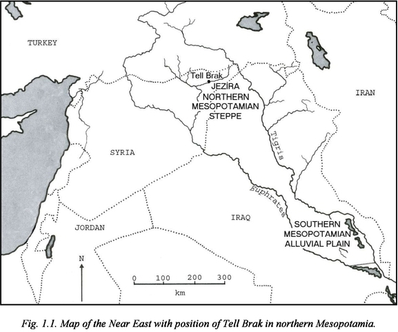
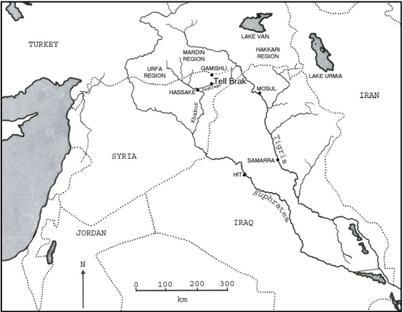
The archaeobotanical record of the Near East suffers from a lack of reported Late Chalcolithic plant remains. The large amounts of well-preserved charred plant remains at Tell Brak however provide us with much needed information on Late Chalcolithic agricultural practices. Comparisons can then be made with the limited amount of material recovered from other contemporary sites in the Near East. The archaeological focus of this volume, Tell Brak, is a multi-period settlement with extensive Late Chalcolithic occupation levels. An almost complete chronological sequence from the Late Chalcolithic has been excavated on the site which allows us to follow not only the growth of the settlement from a town to a regional centre in the beginning of the Late Chalcolithic but also, in the later half of the Late Chalcolithic, the arrival of southern Mesopotamian material culture -- possibly southern settlers -- to this northern settlement and the effects a southern presence may have had on the local community. Chapter 2 Environmental setting of the study 2.1. Introduction The main area of the present study is northern Mesopotamia. The geographical division between northern and southern Mesopotamia can be set along a line between the Euphrates and Tigris rivers by the towns of Hīt and Samarra (Fig. 2.1) where the southern alluvial plain meets the limestone plateau of the Jezira [Upper Mesopotamia] (Lloyd 1984:14). The environmental diversity of Mesopotamia is the cause of a material diversity in terms of the variation in number and range of natural resources which has again created a cultural division of north and south, which is visible throughout the history of the region (Frangipane 1997:46).
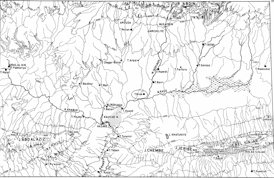
Tell Brak is situated in the southern part of the Khabur region by
the confluence of two wadis feeding off the Khabur River --
the Wadi Jaghjagh and Wadi Radd. Though the
Jaghjagh is only a small stream today the importance
of the wadi in the past can be seen from the number of
large tells situated along its banks (David Oates -- Joan Oates -- Helen McDonald 2001:xxvii).
There are no estimates of the size of the wadi in the past but it is thought to have
been of a �considerable� depth in the third millennium
BC as it was also observed to be during the
excavations at Tell Brak in the 1970s and 1980s (ibid:xxix). The limited size of the wadi today is partly
the result of the drop in the water table from the use of
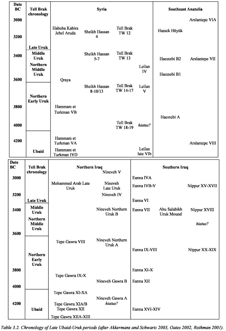
petrol-driven irrigation pumps (David Oates 1990:389). Regarding the agricultural potential of the region an important topographic feature is the wide plains of the area. Though in terms of per-unit cultivation dry-farming is considered half as productive as irrigation agriculture (Weiss 1986:95 and Wilkinson 1990:89) the much vaster amount of land available for cultivation in northern Mesopotamia compared to that in the south meant that the total amount of crops produced were potentially as great as or even greater than what could be achieved in southern Mesopotamia (Weiss 1986:74). 2.1.2. Geology and soils Northern Mesopotamia is formed mainly of Tertiary sedimentary rocks locally overlaid by Quaternary alluvial gravel fans and basalt lava flows (Wilkinson 1990:87). The most common soil type in the region is calcic xerosol, a semi-arid soil which is generally regarded as very fertile (ibid:89-90). Weiss (1986:81-2) describes the land around Tell Brak as consisting of �Mediterranean� brown and red calcareous soils on conglomerate. Guest (1966:71-2) observes that the soils of the moist steppe, that is steppe receiving 350-500 mm yearly rainfall, have been impoverished due to the continuation of dry-farming through millennia, with the soils suffering leaching and erosion. A similar point is made by Smith and Young (1972:48) arguing that increasingly shorter fallow intervals throughout the Holocene have resulted in a decline in soil fertility. French (2003:237) suggests that the silty clay alluvial soils along the Wadi Jaghjagh were rich in nutrients in the past and it is thus reasonable to assume that the soils in northern Mesopotamia were more fertile in the Late Chalcolithic than they are today. On the lower dry-steppe (receiving 200-350 mm rain annually) on the other hand, Guest (1966:71) notes that due to the irregularity of the rainfall and consequently the change between years of sufficient rain for dry-farming and years of drought, the soils have not been exhausted and are able to give high crop returns in good years. 2.1.3. Past and present climate The past climate of the region has been reconstructed mainly by pollen cores taken from lakes in Syria, Turkey and Iran (Bottema 1989, Willem van Zeist and Bottema 1982). The pollen data from Lake Ghab in northwestern Syria shows that around 11,000 BP the region saw increased precipitation levels and a rise in temperature, as indicated in the spread of forest in northwestern Turkey; the gradual increase in humidity appears to have reached modern levels by 5500 BP (Bottema 1989:6) ... The establishment of the present-day distribution of steppe and forest took place at 6000 BP. The general trends therefore indicate a wetter and warmer climate in Mesopotamia after 12,000 BC until the early third millennium BC, with denser oak forest in the Taurus and northern Zagros Mountains and a heavier grass cover on the steppe lands. The climate thus appears to have been wetter and warmer in the Late Chalcolithic than it is today (Miller 1997a:124), meaning that Late Chalcolithic farmers potentially would have been able to exploit a larger area for reliable dry-farming than at present (Wright 2001:128). While conditions overall may have been better in terms of dry-farming, it is still likely that there were minor climatic fluctuations throughout the Late Chalcolithic. From about 3200 BC global aridification appears to have set in, changing the climate in northern Mesopotamia towards a drier environment (Weiss et al 1993:1001). Weiss (2002) suggests that this abrupt climate change to a drier environment lasted for about 200 years. In the case of sites situated near the 300 mm isohyet [where dry-farming is possible without irrigation] that would mean a decrease to 225 mm, insufficient for a dry-farming economy (ibid). Even with a less precise estimate it is clear that any reduction in precipitation in this marginal area would have considerable effects on agricultural production. 2.1.4.2. Past vegetation Over most of northern Mesopotamia today the original steppe vegetation has been replaced by farming and grazing land ... Much of the Jezira was re-settled in the early 20th century and had until then been extensive nomadic pasture land (Wilkinson 1990:91). Smith and Young (1972:23) describe the region as �fairly inhospitable country deeply etched by wadis and marked with patches of marsh country, suitable primarily for exploitation by pastoralists� ... Much of Syria�s steppe areas were thus cultivated relatively recently. Pollen records (Bottema 1989:5-6) show that the Eastern Mediterranean and Near East were covered in steppe and desert-steppe about 15,000 years ago and that forests were found mainly in the Levant and along the Black Sea coast. Plant growth was restricted by lower levels of both temperature and humidity. By the Late Chalcolithic the region around Tell Brak is thought to have been that of open steppe with clusters of riverine forests and with heavily cultivated areas nearer to the cities, especially towards the north where higher rainfall levels than to the south were to be expected (Oates, Oates and McDonald 2001:xxviii-xxix). Towards the south the area was less densely inhabited and there may have been areas of marshland along the Wadi Radd (ibid). 2.1.5 Water resources and irrigation 2.1.5.1. Present Tell Brak is situated in the southern dry-steppe zone which averages annual rainfall of between 200 and 350 mm, at or below the limit of reliable dry-farming ... Reliability and timing of rainfall is more important to successful dry-farming than actual quantity of rain. Oates, Oates and McDonald (2001:xxviii) note that in the 1970s the dry-farming limit was said to lie at the latitude of Chagar Bazar, only some 20 km northwest of Tell Brak ... The timing of the rain through the crop growing period is of equal importance to a successful crop. Tell Brak lies just below the 300 mm rainfall isohyet. The area receives an average 284 mm annual rainfall, most of it in November-February, and is thus below the dry-farming limit in dry years. The location of Tell Brak close to several wadis means that the site may be lying on the watershed between two of these wadis, and at least part of the water consumption of the site may have been provided by drilling for ground water in the past. Wells have been excavated on-site from third millennium BC contexts, though no evidence for wells has been reported from the Late Chalcolithic levels. Apparently, until recently Tell Brak was known for the quality of its water, and one nearby village is named Bir Helu or �sweet water/well� (Wilkinson et al 2001:4). Late Chalcolithic rainfall levels are difficult to estimate with any precision; given the marginal position of Tell Brak, even minor fluctuations in annual rainfall levels could have had major consequences for the agricultural potential in the immediate environs of the site. However, there does appear to be indications of a warmer and wetter climate during this period than today, and annual rainfall levels may have been well over 300 mm in the Late Chalcolithic, possibly with a decrease towards the end of the period. 2.1.5.2. Irrigation in the past Evidence for the fields around Tell Brak having been irrigated in the past is ambiguous. The Euphrates and Tigris rivers, along with their tributaries, primarily the Balikh and Khabur rivers, are potentially useful for irrigation practices. Unlike southern Mesopotamia, where the Euphrates and Tigris have been known to rapidly change their courses, the rivers of northern Mesopotamia are securely situated in deep river beds, which means that they are potentially reliable sources for irrigation water to nearby settlements. The suggested wetter climate in the fourth millennium BC would have entailed higher water levels and height of the water table than today, and as the wadis Jaghjagh and Radd are thought to have been carrying more water in the past than today, irrigation should have been possible in the past. A relevant question to the discussion of the use of irrigation at Late Chalcolithic Tell Brak is whether this practice was at all necessary at the time. Climate reconstructions suggest that the fourth millennium BC may have seen a slightly wetter and warmer climate than today; and given the present position of Tell Brak on the margin of dry-farming land, even slight increases in rainfall levels to what they are now may have secured the dry-farming potential of the area around Tell Brak. The earliest direct archaeological evidence for irrigation in the Near East is from sixth-millennium BC Choga Mami in the Mandali area in southeast Iraq where a system of ancient water channels running off the Gangir and Ab-i-Naft rivers has been found (K�hne 1990:15, David Oates and Joan Oates 1976:125 and 128-132); given its later date and the connections with communities in southern Mesopotamia the inhabitants of the Late Chalcolithic settlement at Tell Brak would thus potentially have had the necessary skills and knowledge for the use of an irrigation system. In Syria Neolithic Mureybit has yielded archaeobotanical and palynological indications for irrigation in levels dating to the ninth and seventh millennia BC (Miller 1980:331). There is no archaeological evidence for canals in the Khabur Valley until the first millennium BC (McCorriston 1995:34), though K�hne (1990:15) suggests that irrigation systems may well have existed in the region from the Early Bronze Age onwards. The earliest textual evidence for irrigation agriculture in northern Mesopotamia is from the Old Assyrian period, i.e. late second millennium BC (Weiss 1986:80) and irrigation is not thought to have been used in the Euphrates valley west of the Khabur Valley until Roman times (van Zeist and Bakker-Heeres 1988:283). In modern times irrigation practices in northern Mesopotamia were unusual until the introduction of petrol driven pumps. Around Tell Brak no definite archaeological evidence in the shape of ancient artificial water channels has been uncovered to suggest that fields were irrigated in the past. The river Jaghjagh, which runs at a distance of roughly 3 kilometres from the site today, may have had some of its water directed towards Tell Brak via an artificial channel (Wilkinson et al 2001:2) though it has also been suggested from the evidence of satellite images that the wadi itself may have run next to the foot of the mound in the past (Sommerfield, Archi and Weiss 2004). Archaeological evidence for irrigation is thus inconclusive. 2.2. Traditional crop husbandry practices and crop yields in northern Mesopotamia The dominant crops in the region are winter wheat and barley, and in the more northerly parts of the region, also pulses (mainly lentils) and vines (Naval Intelligence Division 1943:255-6 and Wilkinson 1990:90). Flax is also mentioned as a winter crop in northern Iraq (Charles 1990:48). While wheat is grown for human consumption barley is primarily grown for fodder. In areas where irrigation is possible, e.g. along the rivers, fruit and vegetables such as melons and cucumbers are grown and summer crops such as cotton and sesame have been introduced. In northern Mesopotamia today most rain falls during the autumn and winter and modern crop sowing is timed according to the autumn rains. At the other end of the growing period the crop is dependent on the April rains in order for the grains to grow to a sufficient size (David Oates and Joan Oates 1976:113). Traditionally cereal crops are broadcast and fields may be cross ploughed afterwards to cover the seeds (Charles 1990:51). In the area around Tell Brak today most fields are irrigated by petrol driven pumps. Crops are usually sown in October-December and harvested in May-June. The sowing of winter cereal crops appears to have been the norm in ancient times as well with no mention of summer cereal crops in ancient texts (David Oates and Joan Oates 1976:117). In the recent past a third to half of the agricultural land was allowed to lie fallow for a year to regain its fertility and moisture content over the winter (Naval Intelligence Division 1943:251). Fallowing recovers the fertility of the land, thus making it possible to cultivate it for longer; it reduces salinisation of irrigated land and provides grazing land for livestock (Charles 1990:47-8). Wilkinson (1990:91) estimates that the practice of fallowing results in crop yield increases of 150-200%, i.e. growing crops every other year after a fallow period yields roughly as high a crop yield as annual harvesting but without exhausting the soil. [Therefore without irrigation] agriculture in northern Mesopotamia is dependent on a much larger area of agricultural land to grow a crop compared to southern Mesopotamia, but with much more land available in the north compared to the south, northern Mesopotamia is probably at least as productive agriculturally as the southern alluvial plain. Chapter 3 Archaeological and socio-political overview 3.1.1. Chronology of early Mesopotamian civilisations The chronological phases of Mesopotamia covered in this study are summarised in Tables 3.1 and 3.2 ...
 The Late Chalcolithic covers all of the fourth
millennium BC and is also named the Uruk period
after the largest city of that time in southern
Mesopotamia. The Uruk period is generally assumed to
have lasted roughly between 4200 and 3100 BC and is
divided into several phases, from Early to Late Uruk,
including in the north local sub-phases (northern
Uruk phases). "Late Chalcolithic� (with phases abbreviated
LC 1 to 5) and �Uruk period� are used interchangeably
and when discussing the data specifically from Tell
Brak the period designations used are those of the TW
sequence, i.e. including �northern Uruk� occupation
levels (Table 3.3).
The Late Chalcolithic covers all of the fourth
millennium BC and is also named the Uruk period
after the largest city of that time in southern
Mesopotamia. The Uruk period is generally assumed to
have lasted roughly between 4200 and 3100 BC and is
divided into several phases, from Early to Late Uruk,
including in the north local sub-phases (northern
Uruk phases). "Late Chalcolithic� (with phases abbreviated
LC 1 to 5) and �Uruk period� are used interchangeably
and when discussing the data specifically from Tell
Brak the period designations used are those of the TW
sequence, i.e. including �northern Uruk� occupation
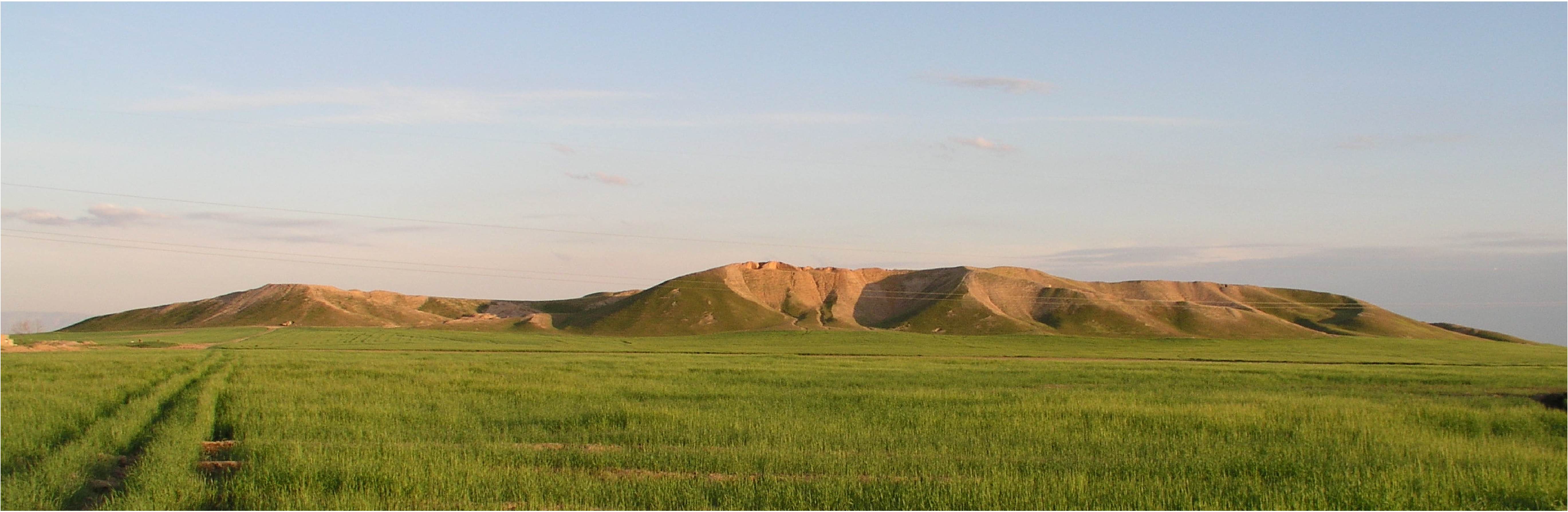
levels (Table 3.3). 3.1.2. The natural resources of Mesopotamia The contrasting geography of Mesopotamia and its neighbours to the north and east, and the unequal distribution of natural resources following this diversity, has been a major factor in shaping the history of the region ... The dependency on the rivers meant that changes in water courses and salinisation of fields due to irrigation, both of which were regular events, had major effects on the settlements; surveys have shown how abandoned settlements can often be seen along old river courses. 3.1.3. The role of exchange in the development of complex society During the middle and late phases of the Late Chalcolithic a number of sites to the north and east of the southern Mesopotamian alluvial plain were established, the material assemblages of which are indistinguishable from those of the cities to the south. The sites have been interpreted as southern Uruk colonies and as they are mainly located along major trade routes, such as the Euphrates and the gateways into the plains of Susiana and Anatolia, their purpose has primarily been explained in terms of long-distance exchange. This appearance of southern Uruk colonies has been described as the "Uruk Expansion� (Algaze 1993); as the term implies, southern Uruk culture has traditionally been viewed as the active agent of this event while the northern Mesopotamian communities were considered relatively passive hosts to this expansion from the south. 3.2. A brief look at the Ubaid period 3.2.1. Southern Mesopotamia The Ubaid period in southern Mesopotamia saw the organisation of small village communities, usually 5-10 hectares in size, into two or three-level settlement hierarchies (Stein 1994:38, Wright 1994:71), living on a mixed subsistence of farming and animal husbandry and hunting and gathering. Surveys in the vicinity of the Ubaid period towns of Eridu and Ur have indicated (from ceramics scatters) that the surrounding smaller settlements cultivated larger areas of land than needed for covering their basic subsistence needs; it has been suggested that these villages may have been providing larger towns with agricultural surplus (Stein 1994:42) and we may see here the beginnings of the Late Chalcolithic tributary economy. Animal bones from excavated sites show that sheep, goats, cattle and pigs were kept and that birds, gazelle and onager were hunted (Pollock 1999:81-3). Agricultural products included wheat and barley, flax, figs, lentils and other pulses and possibly also a variety of vegetables and fruit that rarely survive. 3.2.2. Northern Mesopotamia Ubaid period sites in the north are mainly restricted to areas along the Euphrates and its tributaries the Balikh and Khabur, and along the Tigris in modern northern Iraq. The sites are generally small � from less than one to four hectares but some as large as ten hectares � and may in some cases have formed part of two-tier settlement systems (Lupton 1996:34). The architecture found on the sites is mainly of a domestic character with associated bread ovens and granaries and the subsistence mode of mixed agriculture and hunting-gathering appears to be similar to that described for the south. The production of most commodities is thought to have taken place at the level of small local workshops and storage of cereals appears to have been at the household level (Akkermans and Schwartz 2003:171). 3.3. The Late Chalcolithic 3.3.1. Southern Mesopotamia Surface surveys in southern Mesopotamia (Adams 1981, Adams and Nissen 1972) have shown how the Ubaid period settlement pattern of widely dispersed small villages and towns changed dramatically during the Late Chalcolithic. The Early and Middle Uruk period (LC 2-4) saw a large increase in number of settlements on the Mesopotamian alluvium, mainly centred in the area around Nippur. 3.3.2. Northern Mesopotamia and the �Uruk Expansion� A study of north Mesopotamian settlement patterns (Lupton 1996) has indicated that the northern settlements were not affected to any large extent by the presence of southern Mesopotamian settlers. Lupton argues that the area around Tell Brak, for instance, most probably had a three-tier settlement system before contact with southerners (ibid 34) and that northern Mesopotamia in general was organised into hierarchically structured regional systems (ibid 99) with little change from contacts with southerners. The amount of influence southern Mesopotamia may have had on the formation of northern Mesopotamian complex society is, therefore, possibly of a lesser degree than initially anticipated. 3.3.3. Evidence for north-south interaction By the time of the Early Dynastic period, i.e. early third millennium BC, the southern Uruk colony sites had been abandoned. On many of the local northern Mesopotamian sites with southern Uruk material remains, there is either a discontinuation of occupation or a change to a completely local northern material culture at this time. At Tell Brak however north-south contacts seem to have continued, as evidenced by the presence of southern Jemdet Nasr pottery not usually found outside southern Mesopotamia (Akkermans and Schwartz 2003:207). Chapter 4 Tell Brak: Gateway between north and south 4.1. Tell Brak Tell Brak is situated in the Jezira region in northeast Syria some 50 km north of the modern city of Hassake. It is a multi-period settlement that appears to have been occupied continually for several millennia; the earliest occupation layers so far excavated (in the CH test trench) are dated to the Ubaid period or the fifth millennium BC and the tell appears to have been finally abandoned sometime between 1200 and 900 BC. Virgin soil has not been reached in any of the excavation areas so far; as the Ubaid levels in CH were found at a height of 12 metres above the plain the tell appears to have been of a considerable size already by then (Joan Oates and David Oates 1997:296) even considering the possibility that the settlement may have been founded on a natural high point on the plain. Ceramics and chipped stone characteristic of, respectively, the earlier Halaf and Pre-Pottery Neolithic B periods suggest that the occupation of Tell Brak may go back to at least the seventh/eighth millennium BC. The site was first excavated by Max Mallowan in 1937-8 (Mallowan 1947) and subsequent excavations have been carried out at Tell Brak regularly since 1976. Area CH: The earliest levels so far excavated date to the mid-fifth millennium BC (Late Ubaid and Late Chalcolithic 1 in Area CH). These levels include monumental buildings dating to at least as early as the end of the Ubaid Period (2). The long occupation of Tell Brak is reflected in the size of the central mound today, covering some 45 hectares and rising about 43 metres above the surrounding plain.The site is estimated to have covered about 50 hectares in the Late Chalcolithic 2 (Early Uruk period) and grew to over 130 hectares during the Late Chalcolithic 3-4 (Joan Oates et al 2007:597). This is thought to be roughly the same size as the largest contemporary cities on the southern alluvial plain (Joan Oates and David Oates 1997:290). LC2 (4200-3850 BC) For the Late Chalcolithic 2 period we have data from a range of sites across upper Mesopotamia. Calibrated radiocarbon dates suggest that the LC2 period ranges from circa 4200-3850 BC. Although the LC2 apparently overlaps at least partially with the Early Uruk period in Lower Mesopotamia there is no material evidence for southern cultural influences on the north in the late 5th to early 4th millennia BC. It is possible to identify a number of characteristic ceramic types (Figure 5) that link across from the Euphrates to the Khabur at Hacinebi, Zeidan, the �southern extension� of Hamoukar (Khirbat al-Fakhar) and Brak (Page 135 in 3).
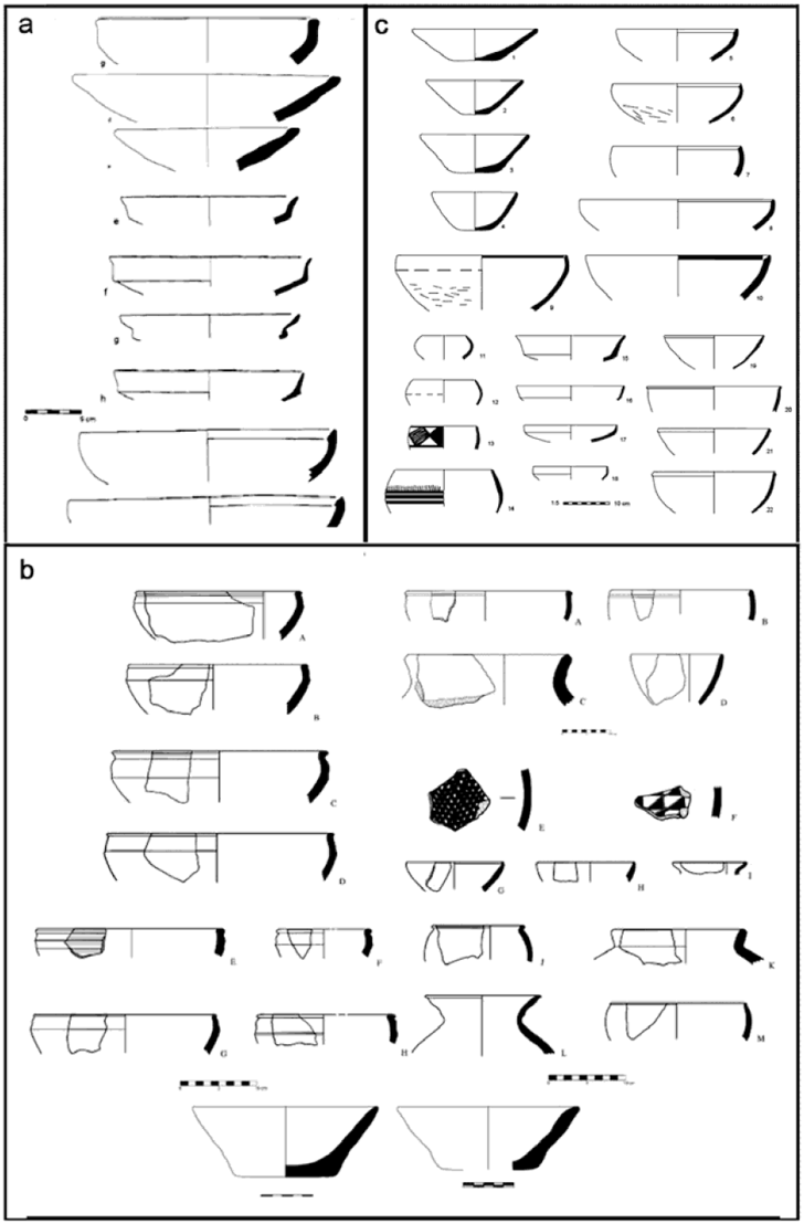 Figure 5 --- LC2 Ceramics at (a) Hacinebi -- (b) Zeidan -- (c) Hamoukar Southern Extension / Khirbat al-Fakhar (Page 134)
Fieldwork at sites such as Tell Brak and Hamoukar
(and its suburban area of Khirbat al-Fakhar) in Syria (Oates et al 2007)
has demonstrated that stable urban centers were present in the north by the late 5th
and 4th millennia BC. The idea of the temporal primacy of southern Mesopotamia
as the location of the first cities, long taken as a given in Near Eastern archaeology,
no longer holds (Page 562 in 4) ... A third millennium BC tablet from nearby Tell Beydar has revealed that the ancient name of Tell Brak was Nagar and that the city was an important regional centre during this time (Emberling and McDonald 2001:21). Later texts from Mari imply that Nagar may have held an important religious position in the region (Matthews and Eidem 1993:203). Tell Brak appears to have ruled over Tell Beydar and to have had commercial relations with other large regional centres like Mari and Ebla (from where texts have been found mentioning the city of Nagar), the latter of which appears to have depended on its supply of a type of equids, possibly onagers, from Tell Brak in exchange for oil (Archi 1998). The function of Tell Brak as an administrative centre during the Akkadian period (late third millennium BC) is reflected in the large �Naramsin Palace", a well fortified building containing narrow storage rooms, probably used for the storage of goods collected from the near region (Akkermans and Schwartz 2003:279, David Oates and Joan Oates 2001:19). The size of Tell Brak and the complexity of its architecture in the Late Chalcolithic certainly testify to the importance of Nagar during this time as well. Tell Brak appears to have been an urban centre within the Mitanni Empire in the 14th century BC (Oates, Oates and McDonald 1997). Monumental architecture like that of the Eye Temple (mid fourth millennium BC), the Naramsin Palace (circa 2200 BC) and the later Mitanni Palace (14th century BC) provide evidence for the significant role Tell Brak must have played throughout its history.
The importance of Tell Brak is probably due first of
all to its excellent strategic position: the city lies as a
gateway controlling not only access to the fertile
Khabur region from southern Mesopotamia but also
further access into the resource-rich Anatolian plateau.
To the east it guards the trade routes into Iran and
further on to Afghanistan from where precious
commodities like lapis lazuli made their way into
Mesopotamia from very early onwards. The trade
routes controlled by Tell Brak were in use for
millennia; part of a Roman road and castellum in the
vicinity of Tell Brak shows how the same routes were
still in use a thousand years after the city of Nagar was
finally abandoned. The major route of communication
between northern and southern Mesopotamia in the
fifth and fourth millennia BC appears to have been via
the Tigris coming up from the southern plains, crossing
the Jezira south of the Sinjar mountains and going via
the Khabur and Balikh rivers down to the Euphrates,
along which access to the Anatolian plain was possible
(Matthews 2003c:37). Alternatively access to the
Khabur plain and the southeastern Anatolian plain was
possible going up the Khabur past Tell Brak. The location of Tell Brak between the fertile plains to the north and the drier steppe lands to the south also meant that the site was situated between population groups involved in different kinds of economies; Tell Brak may have functioned as a centre for the exchange of goods between sedentary farmers and mobile pastoralists (Wilkinson et al 2001:1-2).
Tell Brak is situated about 3 km from the wadi
Jaghjagh, a tributary of the Khabur River. Though it
has been suggested that the Jaghjagh ran all the way up
to Tell Brak in the past (Sommerfield, Archi and Weiss
2004), this has not been finally proved and the
presence of a linear feature running up to the tell may
be the remains of an artificial channel running towards
the Jaghjagh (Wilkinson et al 2001:2). Nevertheless it
is likely that the Jaghjagh was used for the transport of
goods (Eidem and Warburton 1996:52-3, Wilkinson
1994:503). A late Akkadian period text mentions
40.000 litres of barley being shipped from Nagar to the
southern Mesopotamian city of Sippar, suggesting that
northern Mesopotamian agricultural produce was
collected at Tell Brak and from there transported by
donkey or river to the south (Sommerfield, Archi and
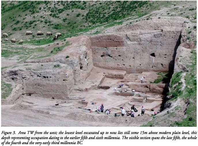
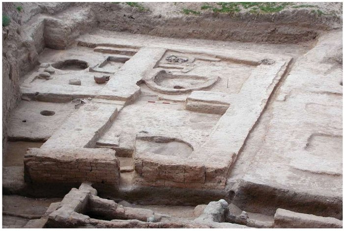
Weiss 2004). 4.2. Tell Brak during the Late Chalcolithic At Tell Brak occupation levels covering almost the entire Late Chalcolithic have been excavated. The excavators have designated some of the Late Chalcolithic phases northern (i.e. LC 2 = Northern Early Uruk and LC 3 = Northern Middle Uruk; David Oates and Joan Oates 1993:172) in order to distinguish levels with purely local northern material culture from those levels containing southern Mesopotamian material remains (Table 3.3). The finds at Tell Brak of large public structures and the fact that the site reaches a size of over 130 hectares already during the LC 3-4 suggest that Tell Brak was already a large regional centre within a complex settlement system by the time of contact with southerners, a settlement system that had developed independently in the north during the late fifth and early fourth millennia BC before any contact with southerners in the region. During the later half of the fourth millennium BC Tell Brak seems to have reached a size almost equal to that of the city of Uruk, the largest of the cities on the southern Mesopotamian alluvial plain. Excavations in area TW at Tell Brak have uncovered large monumental architecture dated to before contact with southern Mesopotamia, as well as a numerical tablet and pictographic dockets from Northern Middle Uruk levels, an earlier date than the one assigned to the pictographic tablets found in the city of Uruk in Eanna level IV and possibly reflecting a local administrative development (Jasim and Oates 1986:360, Joan Oates and David Oates 1997:289-91). Around the settlement mound eleven satellite sites have been investigated, all dated to the Northern Middle Uruk period (Emberling et al 1999, Emberling and McDonald 2001). It has been suggested that these sites functioned as specialised agricultural sites supplying the main settlement with agricultural produce on an either full-time basis or during dry years when the larger settlements were not able to produce sufficient crops for their inhabitants (Algaze 1993:24). The sites may have either produced the crops or administered and stored crops imported from a greater hinterland. A similar arrangement of smaller sites around a larger settlement is seen at contemporary Hamoukar. 4.2.1. Late Chalcolithic population density and carrying capacity of Tell Brak Though Tell Brak lies on the margin of reliable dry farming land, farmers at Tell Brak may have had more suitable conditions available in the fourth millennium BC due to a combination of higher levels of usable rainfall and a higher watertable, especially in the vicinity of the wadis Jaghjagh and Radd ... Tell Brak may however have depended on its hinterland to produce a sufficient agricultural crop to feed its citizens ... Wilkinson (1994:489-90) concludes that settlements in northern Mesopotamia were never too large for their agricultural surroundings but were always self-sufficient. Considering the agriculturally marginal situation of Tell Brak and estimating that agriculture in northern Mesopotamia would have needed a larger area of land than in the south, a 10 km radius of agricultural land around Tell Brak should be a reasonable amount of land for the settlement to be self-sufficient, which has also been suggested by Emberling (2003:264). This estimate would also leave room for agricultural land between the many smaller sites in a 20 km radius around Tell Brak that have been noted by recent survey work (Ur et al 2007). Preliminary results from the survey show that from the LC 1-2 135 sites have been observed while 168 sites were dated to LC 3-4/5. Even considering that these sites are unlikely to have been occupied all at the same time the region around Tell Brak was certainly far from empty of settlements during the Late Chalcolithic. 4.3. The excavation areas 4.3.1. TW Excavations in area TW were begun in 1981 and the area is still under investigation. TW covers nearly 600 square metres; over 10 metres of fourth and early third millennium BC deposits have been excavated so far from LC 2 (circa 4400-3900 BC) to early Ninevite V (circa 2800 BC) and so far twenty levels of deposits have been distinguished -- including twelve levels covering almost the entire Late Chalcolithic -- the only excavation area in the Near East to do so (Table 3.3).
4.3.4. Tell 2 Tell 2 is one of eleven satellite sites surrounding Tell Brak within a radius of between 500 and 1100 metres from the centre of Brak itself. A survey undertaken of the immediate region around Tell Brak showed that the smaller tells lying in a circle around the tell, none of them larger than 4 ha, had all been established in the Northern Middle Uruk period and are thus contemporary with the Level 18 Building and Level 16 Houses in TW. Subsequent excavation in 2000 of Tell 2 southeast of the main mound has produced evidence of private residences and of pottery production (Emberling and McDonald 2001:45).
(1) A Thousand Years of Farming: Late Chalcolithic Agricultural Practices at Tell Brak in Northern Mesopotamia by Mette Marie Hald --- BAR International Series (2008)
(2) Tell Brak Project --- McDonald Institute for Archaeological Research (University of Cambridge)
(3) Origini - XXXIV 2012: Prehistory and protohistory of ancient civilizations (Gangemi Editore SpA International Publishing)
(4) A Companion to the Archaeology of the Ancient Near East: Volume 1 --- Edited by D.T. Potts (2012)
Heartland of Cities: Surveys of Ancient Settlement and Land Use on the Central Floodplain of the Euphrates by Robert McCormick Adams --- University of Chicago Press (1981)
The Uruk Countryside: The Natural Setting of Urban Societies by Robert McCormick Adams and Hans Nissen --- University of Chicago Press (1972)
The Archaeology of Syria: From Complex Hunter-Gatherers to Early Urban Societies (circa 16,000-300 BC) by Peter Akkermans and Glenn Schwartz --- Cambridge University Press (2003)
The Uruk Expansion: Cross-cultural Exchange in Early Mesopotamian Civilization by Guillermo Algaze et al in Current Anthropology Pages 571-608 (1989)
The Uruk World System. The Dynamics of Expansion of Early Mesopotamian Civilization by Guillermo Algaze --- University of Chicago Press (1993)
The Regional State of Nagar According
to the Texts of Ebla by A. Arch in Subartu 4/2:1-15 (1998)
Notes on the prehistoric environment of the Syrian Djezireh by Sytze Bottema in To the Euphrates and Beyond: Archaeological Studies in Honour of Maurits van Loon Edited by O. M. C. Haex et al (1989)
Traditional Crop Husbandry in Southern Iraq 1900-1960 A.D. by M. Charles in Bulletin on Sumerian
Agriculture 5:47-64 (1990)
The Uruk Phenomenon: The role of social ideology in the expansion of the Uruk culture during the fourth millennium BC by Paul Collins (2000)
In the Land of Nagar: A Survey around Tell Brak by J. Eidem and D. Warburton in Iraq 58:51-64 (1996)
"Urban Social Transformations and the Problem of the First City" in The Social Construction of Ancient Cities by Geoff Emberling Pages 254-268 (2003)
Excavations at Tell Brak 2000: Preliminary Report by Geoff Emberling and Helen McDonald in Iraq 63:21-54 (2001)
Excavations at Tell Brak 1998: Preliminary Report by Emberling et al in Iraq 61:1-41 (1999)
A 4th-millennium temple/palace complex at Arslantepe/Malatya: North-south relations and the formation of early state
societies in the northern regions of Greater Mesopotamia by Marcella Frangipane in Pal�orient (1997)
Geoarchaeology in Action: Studies in Soil Micromorphology and Landscape Evolution by Charles French (2003)
Flora of Iraq Volume 1: Introduction to the flora by Evan Guest (1966)
Early tokens and tablets in Mesopotamia: new information from Tell Abada and Tell Brak by Sabah Abboud Jasim and Joan Oates in World Archaeology 17/3:348-362 (1986)
"The effects of irrigation agriculture: Bronze and Iron Age habitation along the
Khabur in Eastern Syria" by H. K�hne in Man's Role in the
Shaping of the Eastern Mediterranean Landscape Edited by S. Bottema -- G. Entjes-Nieborg -- Willem van Zeist Pages 15-30 (1990)
The Archaeology of Mesopotamia from the Old Stone Age to the Persian Conquest by Seton Lloyd (1984)
Stability and Change: Socio-political development in North Mesopotamia and South-East Anatolia 4000-2700 BC by Alan Lupton (1996)
Excavations at Brak and Chagar Bazar by M. E. L. Mallowan in Iraq 9:1-87 (1947)
Tell Brak and Nagar by Donald Matthews and Jesper Eidem in Iraq 55:201-207 (1993)
"Traces of Early Complexity: Late Fifth to Early Fourth millennia Investigations: the Early Northern Uruk Period" in Excavations at Tell Brak Volume 4: Exploring an Upper Mesopotamian regional centre by Roger Matthews Pages 25-51 (2003c)
Preliminary Archaeobotanical Analysis in the Middle Khabur Valley, Syria and Studies of
Socioeconomic Change in the Early Third Millennium BC in Bulletin of the Canadian Society for Mesopotamian Studies by J. McCorriston 29:33-46 (1995)
Farming and herding along the Euphrates: environmental constraint and cultural choice
(fourth to second millennia BC) by Naomi Miller in Subsistence and settlement in a marginal environment: Tell es-Sweyhat --- 1989-1995 preliminary report -- Pages 123-132 (1997)
Water use in Syria and Palestine from the Neolithic to the Bronze Age by Robert Miller in World Archaeology 11/3:331-341 (1980)
Naval Intelligence Division Syria: April (Great Britain) 1943
Innovations in Mud-Brick: Decorative and Structural Techniques in Ancient Mesopotamia by David Oates in World Archaeology Pages 388-406 (1990)
"Early irrigation agriculture in Mesopotamia" by David Oates and Joan Oates in Problems in
Economic and Social Archaeology Edited by G. Sieveking Pages 109-135 (1976)
Excavations at Tell Brak 1992-93 by David Oates and Joan Oates in Iraq 55:155-199 (1993)
Excavations at Tell Brak Volume 1: The Mitanni and Old Babylonian periods by David Oates -- Joan Oates -- Helen McDonald at the McDonald Institute for Archaeological Research at Cambridge (1997)
Excavations at Tell Brak Volume 2: Nagar in the third millennium BC by David Oates -- Joan Oates -- Helen McDonald at the McDonald Institute for Archaeological Research at Cambridge (2001)
"The Excavations" in Excavations at Tell Brak Volume 2: Nagar in the third millennium BC by David Oates and Joan Oates at the British School of Archaeology in Iraq --- Pages 15-98 (2001)
An Open Gate: Cities of the Fourth Millennium BC (Tell Brak 1997) by Joan Oates and David Oates Cambridge Archaeological Journal 7:287-307
Early Mesopotamian Urbanism: A New View from the North by Joan Oates et al in Antiquity 81:585-600 (2007)
Ancient Mesopotamia by Susan Pollock Cambridge University Press (1999)
The Evolution of Early Agriculture and Culture in Greater Mesopotamia: A Trial Model by Philip E. Smith and T. C. Young in Population Growth: Anthropological Implications Pages 1-63 (1972)
Why Dada Measured 40,000 liters of Barley from Nagar for Sippar by Walter Sommerfield -- Alonso Archi and Harvey Weiss Poster presented at 4th ICAANE at Berlin Germany (2004)
"Economy, Ritual and Power in Ubaid Mesopotamia" in Chiefdoms and Early States in the Near East: The Organizational Dynamics of Complexity
Edited by G. Stein and M. Rothman Pages 35-46 (1994)
Early urban development in the Near East by Jason Ur et al in Science 317: 1188 (2007)
The Origins of Tell Leilan and the Conquest of Space in Third Millennium Mesopotamia
in The Origins of Cities in Dry-Farming Syria and Mesopotamia in the Third Millennium B.C. Edited by Harvey Weiss Pages 71-108 (1986)
The Genesis and Collapse of Third Millennium North Mesopotamian Civilization by Harvey Weiss in Science 261:995-1004 (1993)
"Ninevite 5 Periods and Processes" in The Origins of North Mesopotamian Civilization: Ninevite 5 Chronology, Economy, Society --- Edited by Harvey Weiss and E. Rova (2002)
Soil development and early land use in the Jazira region, Upper Mesopotamia by Tony James Wilkinson in World Archaeology Pages 87-103 (1990)
The Structure and Dynamics of Dry-Farming States in Upper Mesopotamia by Tony James Wilkinson in Current Anthropology 35/5:483-520 (1994)
"Geoarchaeology, Landscape and the Region" by Tony James Wilkinson et al in Excavations at Tell Brak --- Volume 2: Nagar in the third millennium BC Pages 1-14 (2001)
"Prestate Political Formations" by Henry Wright in Chiefdoms and Early States in the Near East: The Organizational Dynamics of Complexity Edited by G. Stein and M. Rothman Pages 67-84 (1994)
Cultural Action in the Uruk World by Henry Wright in Uruk
Mesopotamia and Its Neighbors Edited by Mitchell Rothman -- Pages 123-147 (2001)
"Vegetational History of the Eastern Mediterranean and the Near East During the Last 20.000 Years"
by Willem van Zeist and S. Bottema in Palaeoclimates, Palaeoenvironments and Human Communities in the Eastern Mediterranean Region in Later Prehistory --- Edited by J. L. Bintliff and Willem van Zeist Pages 277-323 (1982)
Archaeobotanical studies in the Levant 4: Bronze Age sites on the north Syrian
Euphrates by Willem van Zeist and J. A. H. Bakker-Heeres in Palaeohistoria 27:247-316 (1988)
The History of the Ancient Near East Electronic Compendium |