|
Other Archaeological Sites / The Neolithic of the Levant (500 Page Book Online) Tell el-Farah (South) in Israel Updated July 16th 2020 Excerpts and Definitions and Addendums:
International Standard Bible Encyclopedia (1915)
Tell el-Farah (South) -- sometimes referred to as Tell Fara [10] -- is on the west side of Nahal Besor near Ein HaBesor. It was first excavated by Flinders Petrie in 1928 to 1929 ... As of 2013 it is under excavation again [12] ... Petrie first identified the site as Beth-Pelet (Joshua 15:27) and published the excavation reports under the names Beth-Pelet I and II [WikiPedia]
Beth-Pelet I (Tell Fara) by William Matthew Flinders Petrie (1930)
--- Page 1 ---
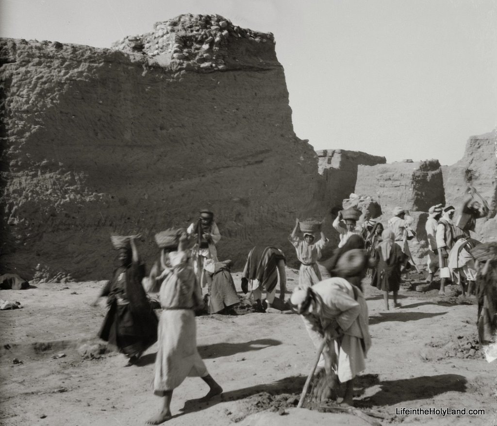
This site, on the west side of the Wady Ghuzzeh, occupies a hill a hundred feet high with nearly fifty feet of ruined towns on the top of it. Moreover it proved to have widely spread cemeteries on the west and north of the hill. It is eighteen miles south of Gaza with open wilderness between; food supply was obtained from there while drinking water was brought eleven miles from Khan Yunis. Though there is no usual camp of Bedawy in the place the former workers of Gerar flocked up and others from many miles round so that a camp was formed of about four hundred men, women and children. During two years in this wilderness there was never any friction with the people nor a single thing missing. CHAPTER I: THE POSITION OF BETH-PELET 1. The coast of Palestine is fringed with a belt of alluvial deposit washed down from the limestone hills and this forms a wide plain at the outflow from the Beersheba basin between the hills which range from the north-east round to the south. The plain has been scoured by the rains into a slightly wavy surface; but this is intersected by torrent beds cut out by the storms from the hills. The soil is fertile enough when there is sufficient rain, a brown marl full of chalky concretions. In historic times however it has always been a border land between the desert and fertility. The region was not classed with the ordinary settlements of the Israelites but was the Negeb [desert] or dry country which contained "the uttermost cities of Judah". Having become slightly drier in later ages it has been resigned entirely to the nomad Arabs, left to wring what they can from it in favourable years. 2. Under Turkish rule it [Palestine] was subject to frequent raids of the tribes from the south and east and only with an escort could it be safely visited. The survey made under Lawrence and Woolley in 1911 to 1914 is the first detailed account in modern times.
The Wilderness Of Zin By C Leonard Woolley And T. E. Lawrence (1914)
The British Museum Excavations at Karkemish (1911-1914 and 1920) edited by Nicol� Marchetti
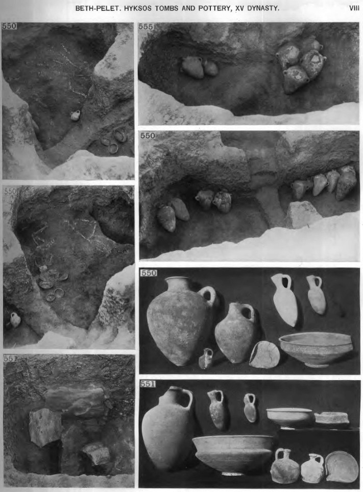
--- Pages 4 and 5 --- 10. The Hyksos pottery was distinctive unlike Egyptian and only distantly resembling that which followed it in the xviiith dynasty (see the Corpus of Palestinian Pottery). https://ancientneareast.tripod.com/PDF/ERA_49_Garrow_Corpus_of_dated_Palestinian_pottery_1930.pdf This Corpus has been built around the Gerar and Bethpelet collection of pottery and the classification adopted is that used by Sir Flinders Petrie there ...
The register of the pottery and other objects is given on Plates xiv and xv. Photographs of the finest groups are on Plate viii. The commonest form was the large water jar (type 43) seen in tombs 555 and 550 Plate viii. In the earlier tombs there is also a larger jar 28 to 31 inches high and 16 wide without handles; it is beautifully shaped for a bulky vessel and very thin for its size. Another type is the one-handled jar in the groups viii 550 and 551 which is also finely formed, better than any large jar of a later age. The bowls are strongly designed with a bold shoulder to stiffen the form and a lip for the edge. The most characteristic types of this age are the short cylindrical bottles and the flat lamps with only a slight spout; such are never seen later.
The most remarkable matter is the distribution of the black prick-pattern vases. They abound in the Hyksos graves at Yehudiyeh yet not one was found at Gerar or Beth-pelet while the scarabs in the graves are identical on each side. This points to an exclusive trade by sea to Egypt from the north. As Cypriote daggers are common at Beth-pelet Cyprus cannot be the source of the black ware but rather North Syria; a few have been found at Megiddo -- Gezer and Byblos. 11. The robbing and the collapse of the chambers had only left three tombs with the objects in position. Number 550 Plate xvii has five skeletons so placed that it is impossible for them to have been swathed for burial. The varied positions of the legs suggest that after death the body was left to stiffen and then carried out and buried as it was. The custom differed therefore from the Jewish -- Egyptian or Greek ideas.
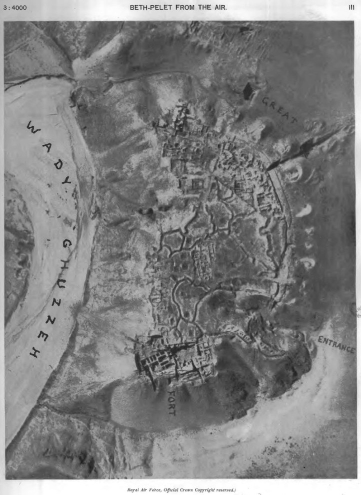
CHAPTER V: BURIALS IN CEMETERIES 100 AND 200 BY OLGA TUFNELL 33. The tombs of the Solomonic period at Tell Fara occupy the sloping ground leading up to the plain north of the Tell and the Beersheba-Khan Yunis road. This rough track descends rapidly to the bed of the Wady Ghuzzeh near Cemetery 100 which consists of late Philistine and Greek graves and it appears to be the southern limit of both burial-grounds. Repeated soundings on and directly south of the road produced no further graves. It is on the north-western end where the marl is close to the surface that the Solomonic tombs lie but the area is limited by deep sand-drifts which were not suitable for burial grounds. Due north a fairly large part was examined but the graves here gradually diminished so that it seems possible that only the crest of the small ridge was used for the elaborate tombs of Solomon's well-to-do subjects ... The cemeteries were separated from each other by roughly 150 feet of unproductive ground and Cemetery 100 borders the road. These earlier and later tombs were small and carelessly constructed and nearly all had been robbed anciently. 34. All the Solomonic graves, with the exception of 204-5 and 222, were stone-lined and covered with large slabs of limestone from the Wady Ghuzzeh. CHAPTER VII : THE FORTRESS 45. Having now traced the history of the place as best shown in the cemeteries we turn to the city itself. On the general plan Plate ii it will be seen how the city occupied a rise on the western side of the Wady Ghuzzeh. This is more graphically shown in the air view Plate iii.
which I owe to the kindness of Group-Captain Playfair. The stream makes a turn at that point and hence the hill being on the wearing side it has always been cut away steeply and forms a good defence on that face (see top Plate i). To the north and south the hill is bounded by two ravines. The mouth of the northern ravine (seen at top of Plate iv) curves round the hill and winds up into it (base of Plate i) ;
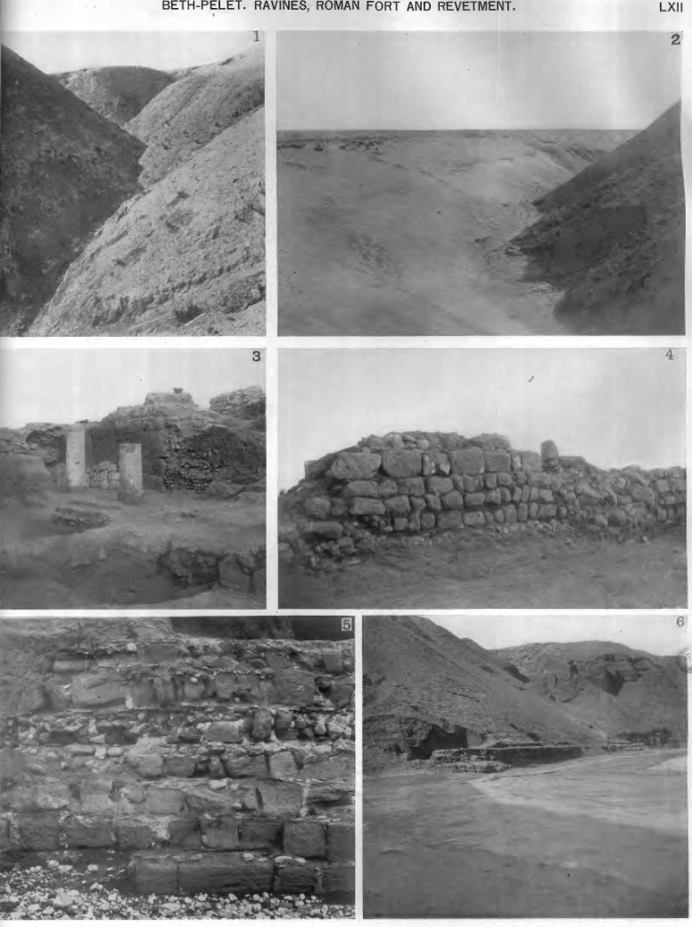
it forms the only access to the top. The southern ravine is not so long and ends bluffly. These ravines were apparently slighter in the natural form and have been deepened and the sides smoothed away to aid in the defence of the city. In lxii #2, looking down the northern ravine, it is seen how in the distance there are a few natural side-gullies near the mouth but the upper part is quite smooth. This is not a natural condition as the usual state of drainage valleys is shown in Plate lxii #1 with frequent side-gullies along the course.
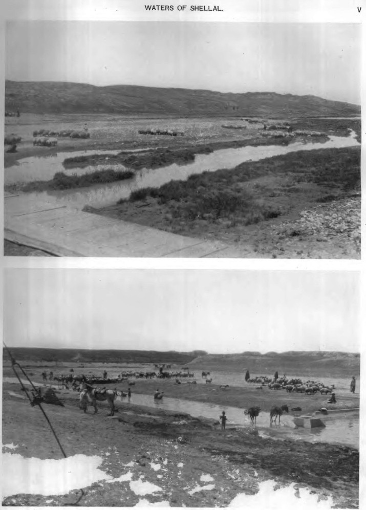
47. The first excavations made here in 1928 by Mr. Starkey and our students were on the south end of the hill. These exposed the remaining part of a fort which guarded the south ravine; from the pottery this is dated to the beginning of the xviiith dynasty. As only a small part was cleared to the bottom this is left to be described when further work is done on this end. In 1929 I felt that the north end of the hill was likely to give important results. First it was the most open to cool winds needed during the greater part of the year. Second it was near the entrance and would guard that. Third it was nearest to the valuable pasture and open water in the valley at Shellal (see Plate v above) about two miles to the north and commanded a wide view over that part of the country. This pasture is essential for a desert outpost being about 25 miles south of the Judaean grass land and would be necessarily held for the road toward Egypt. The views in Plate v I owe to Miss Tufnell as in consequence of the press of work I had no time to visit the spot. On the plan on Plate lii the sides of the Hyksos wall are marked as found to the west at about the middle of the north end, also just above the word "Hyksos" and again on the curve near the cast wall of the black building. The curve is drawn as seems probable through these points but has not been found continuously in the eastern part. The thin walls in open outline are what have been traced beneath the black building. By their levels they are doubtless of the Hyksos period but they do not seem to be parts of any uniform building.
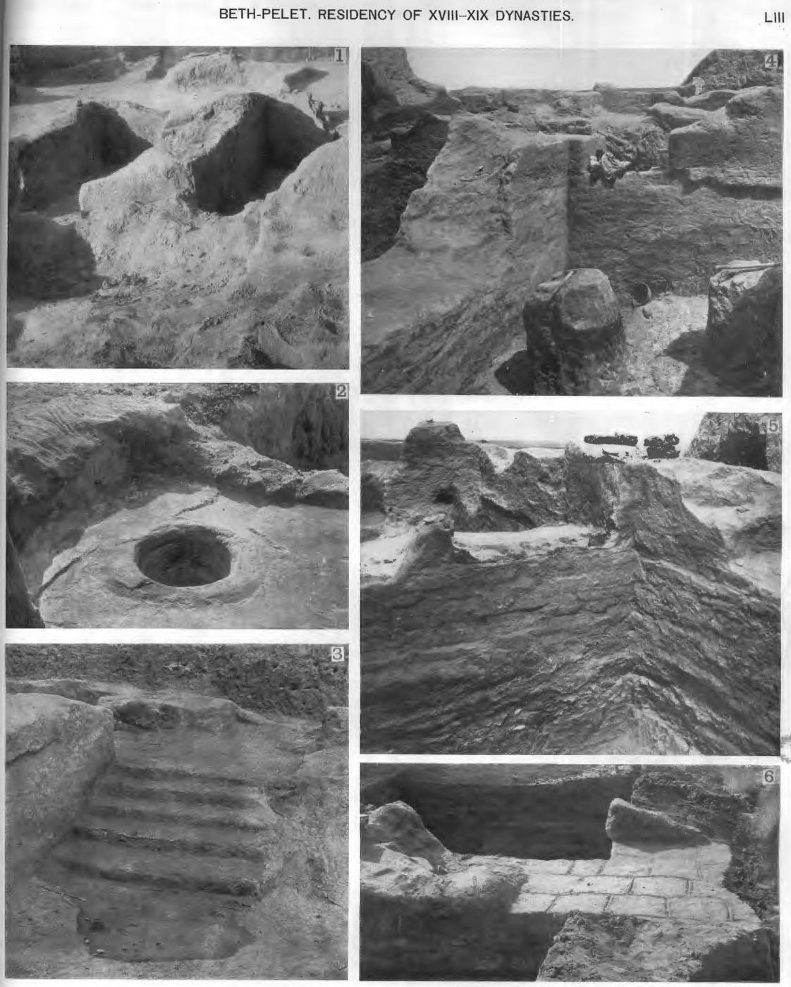
49. The large well-built block of halls which was built over the Hyksos work is doubtless the Egyptian Residency for a governor. All of the foundation walls on Plate lii are of brickwork for some four to six feet up to floor level. These will be seen also in Plate liii pictures 4 and 5: the floor level is marked by the doorways near the top of the walling. Below that the brickwork is regular and continuous.
Now, looking at Egyptian history, Ahomes I
drove the Hyksos out of this region at Sharuhen
(Tell Sheria) and pushed up into Zahi in Phoenicia.
It is probably to him that should be attributed the post-Hyksos fort at the South end with bricks of 22 X 15 1/2 inches and similar very fine yellow brickwork of the small west wall at 380 foot level on Plate xiii.
Thebes was the birthplace of the new kingdom. There ruled here, tributary to the Hyksos, a dynasty who may have been the descendants of the old kings ... When Ahmose came to the throne nearly the whole of the country was free and the country about Hatu'ar (See Footnote 4) (Avaris) alone remained in the hands of the Hyksos. Here they made a desperate stand and it was only in the third campaign that Hatu'ar was taken by storm. Ahmose made good use of his victory and immediately advanced eastwards as far as Sharuhen in the south of Palestine. This advance is important as the first step in the direction afterwards pursued during some centuries by the Egyptian policy. The time of conquest, the "New Empire", begins with Ahmose. The next recorded activity in Syria was by Tehutmes I fighting in the far north at Naharaina (Mesopotamia). [Can find nothing really substantive about Naharaina except in mythology and here:]
He is not likely to have troubled to fortify a place on the frontier next to Egypt. Then, under Tehutmes II and Hatshepsut, the hold on Syria had weakened and Tehutmes III had to assemble his army in Egypt before entering Syria as the chiefs of southern Syria were in revolt. His war would be the probable time for building a strong centre on the road to Palestine. The brickwork of the lower part of the fort is not of the fine yellow clay of the south fort but of browner earth and is of about 19 X 10 inch bricks. This fort of Tehutmes, built with deep foundations in 1480 B.C., remained till the revolt under Akhenaten, which would reach it about 1380. Then the walls above ground were broken down. On the reconquest by Sety I, marked by a stele of his 1st year at Beth-shan in 1326, the Residency would be renewed and to that date not only should the earth walls be assigned to this period but also the upper brick walls as the bricks there differ from those of the foundations, being about 22 X 14 inches. This building by Sety would have lasted on, as there is no sign of revolt there, as late as Rameses III and the line of Philistine lords goes on unchanged from Sety I to the end of the xxth dynasty in or after 1100 B.C. The evidence of pottery agrees with this. The earlier Philistine pottery is found on the floor level of the Residency with part of a massive hard pottery cartouche with a figure of Set and probably of Sety II from 1210 B.C. Lastly, who burnt the building? The Israelites do not seem to have reached this region which was still in the hands of Philistine lords as far as Ziklag about 1020 B.C. The slave raids of the Amalekites, in which they burnt Ziklag with fire and carried everything away, are very likely to have extended to an important place like Beth-pelet which was abandoned by the Egyptians. It is in the fighting in the close of Philistine power that we may date the fall of the old Residency.
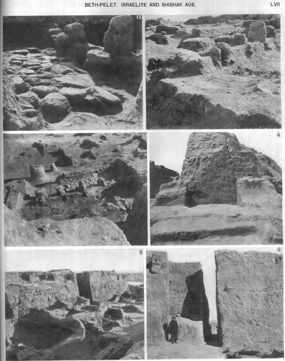
51. Plate LVI. The buildings immediately succeeding on the destruction of the Egyptian Residency are very confused in plan. The only definite unit was the portico VE. From VE to VK is a frontage wall facing north with a stone paving south of it (see above lvii:1): this part was therefore not roofed. South of this is a row of four blocks; these are seen in plate lvii:3 looked down upon from the south. The two in the middle of the row are higher, apparently door jambs (see the south view in lvii:2); the outer two stones are raised and of a smaller size as if they were the footing of two columns supporting the portico front.
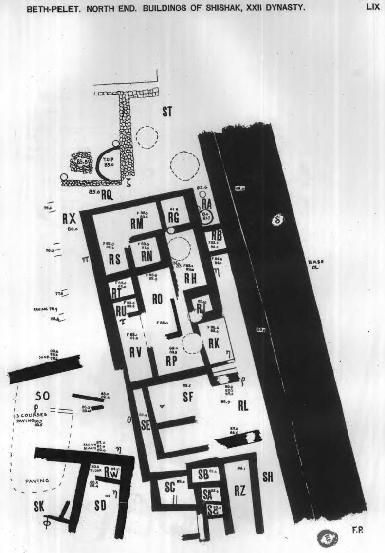
52. Plate LIX --- Here we reach again Egyptian civilisation and good order. The building is of the same style as that of Shishak at Gerar; the foundations are four or five courses deep, all laid in clean sand; the bricks are of 17 to 21 inches as at Gerar and of the same fine yellow clay. There is no other period of building with these characters.
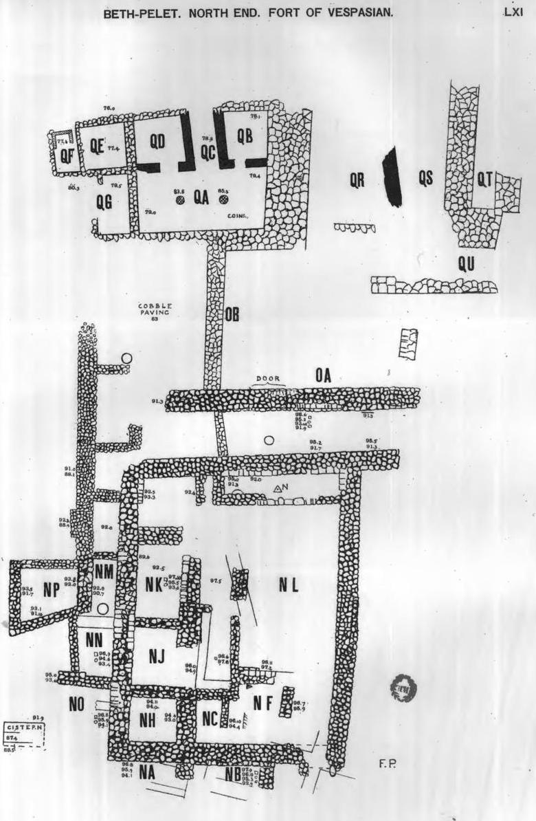
The grand scale and solid building of Shishak, here and at Gerar, gives a new sense of the importance of his conquest. It was not merely a raid on Judah but an occupation in force employing in the south thousands of brick-makers and putting up a great triumphal stele at Megiddo. The views of this great wall are on Plate lvii; 5 is the inner face; 6 shows our cut through it with the inner wall and ash bed removed so as to show the rough brick below the floor level and the smooth plastered face of the wall above F. On the inner wall the junction of the ash bed A with the brickwork B is marked. In view 4 the end of the deep foundation is shown resting on cobblestones and sunk down through the ash bed which is on the left hand. The rest of the foundation and upper part of the wall have been entirely denuded on the right hand by rains and wind on the north face. 54. Plate LXI. The final construction on the hill was the Roman fort. Of this only the cobble-stone foundations were complete and in a few places were some square-dressed blocks of sandstone of the visible walls. The main body is the square fort -- 51 feet by 66 feet; inside was an open court NL and on three sides of that were chambers ... On the west was another thick wall parallel in which was a wide gateway filled up with rough blocks. This wall is shown in lxii:4 with the blocked gate toward the right hand.
Further west the hill slopes down and contemporary buildings were at a lower level. The western hall has two sandstone columns in it (see lxii: 3) covered with white stucco. The brick walls (solid black) seem like a later addition; a tank in QF was probably a bath. On the floor of this hall, sunk just under the dust, were three hoards of coins of the first century. The latest of these was of the vth year of Nero, A.D. 58-9 and as there does not appear to be much coinage after that abundant supply, until the revolt in 66, we may infer that this mass of building was put up during the war of Vespasian and Titus in 67-70. A strong post here would be of use in the isolating of the Jews which was Vespasian's policy. To the same period must be assigned the great revetment wall at the fort of the hill marked in black on Plate li " Roman revetment "; see the view in Plate lxii:6. This view was taken during a flood in the wady and the rush of water hides the lower courses of the wall. It is faced with large well-squared blocks of sandstone; behind these is a mass of blocks (see lxii:5) in regular courses laid in hard lime concrete. 56. Plates LXIV-LXVII. The detailed plans of the cemeteries show how the tombs were grouped. In cemetery 500 the straight line of five great tombs of the Philistine lords is most striking. They proceed in age from north to south. The first (544) is larger than any private tomb and is followed by those of the largest size dated from 1320 to 1050 B.C. (562). The number of bodies indicate that these are family tombs, each containing two or three generations. They cover the period from the Egyptian resettlement under Sety I down to the beginning of the rise of Jewish power under David. To the south of these lies the Hyksos cemetery with a very different form of tomb and placed quite irregularly, opening from the north instead of the east. CHAPTER VIII: THE CONNECTIONS WITH LITERARY SOURCES 58. To realize the gain to knowledge by the results of the work here described we may summarise the bearings of it on the history which was already known. The period of the Hyksos or Shepherd Kings has long been one of the most obscure ages of Egypt. The hatred of the Egyptians had blotted out what might have given us their history and only half a dozen tombs and two earth forts, which I found, have witnessed to their work in Egypt. Otherwise we have only their scarabs without any further history. This is all that was known before the work at Beth-pelet. The first question about them is whether they were a whole population or only a ruling class like the Turks. In Egypt the pottery in their tombs is purely Egyptian; now, in Palestine, we find that it is purely Palestinian, the larger kinds being identical with those of Byblos. Therefore the styles which they followed were those of the country in which they happened to be and they had no distinctive pottery of their own. This seems to prove that they were only a ruling caste in Palestine and similarly, as we know, in Egypt. The earth fort was their mode of defence. The fortification of the mound of Beth-pelet is essentially by long steep slopes and not by a great wall; thus, though on a hill, it resembles the earth forts of Yehudiyeh and Heliopolis which are already recognized as Hyksos. This principle belongs to plain-dwellers as seen in other camps in North Syria and is at one with the Central Asian earth forts or Tepes of the Turkomans. This points to such an origin for the Hyksos; the Semite always thought of a city as walled. 60. On reaching Jewish times the list of 38 of "the uttermost cities of Judah" in the book of Joshua can be identified with modern names in half the instances. Their positions in this list show that Tell Fara is the ancient Beth-pelet. The exclusiveness of the Philistine in the supply of metals left the Israelites fixed in the neolithic stage and about 1100 B.C. they were still keeping up the regular neolithic type of hoe and were chipping flints on a large scale. 63. The jewellery of the Pelethites in the time of Solomon was much richer than that of the Egyptians of that period. This wealth of Palestine reflects the acquisition of the trade routes; both the southern route of Ezion-geber and the northern route by the Euphrates were in Solomon's hands. Thus holding all the traffic between east and west and acting as an astute merchant in horses and linen as recorded, Solomon readily made his land the richest of that age. The position of Shishak has been greatly underrated. Not only did he conquer Jerusalem but he was the greatest of builders in South Palestine. Tens of thousands of men must have been occupied in brick-making and building, for the great wall twenty-two feet thick and the town buildings of Beth-pelet; also the entire rebuilding of Gerar. His foundations are the deepest known and are laid in clean sand. His conquest extended to north of Megiddo as he put up there a colossal tablet of which a piece has been found. Later Vespasian fortified Beth-pelet heavily as a bridle on the Jews passing to Egypt, according to his policy of holding them till they could be overwhelmed. Thus for over two thousand years this place was of high political value and we have reaped much more Egyptian history about the darker ages than has ever been gathered before.
Beth-Pelet II: Prehistoric Fara by Eann MacDonald
https://ancientneareast.tripod.com/PDF/Beth-Pelet II.pdf
BETH-PELET II: PREHISTORIC FARA BY EANN MACDONALD
CHAPTER I: CONDITION OF THE SITES
I. Relation to the Wady Ghazzeh: The alluvial
deposit washed down from the limestone hills, ranging
from the north-east to the south of Beersheba,
forms a plain at the outflow from the Beersheba
basin. Since its formation, as has been stated in
Beth-pelet I, the rains have scoured it into a slightly
undulating surface whilst the flood-water from the
hills have cut a channel through to the sea. This
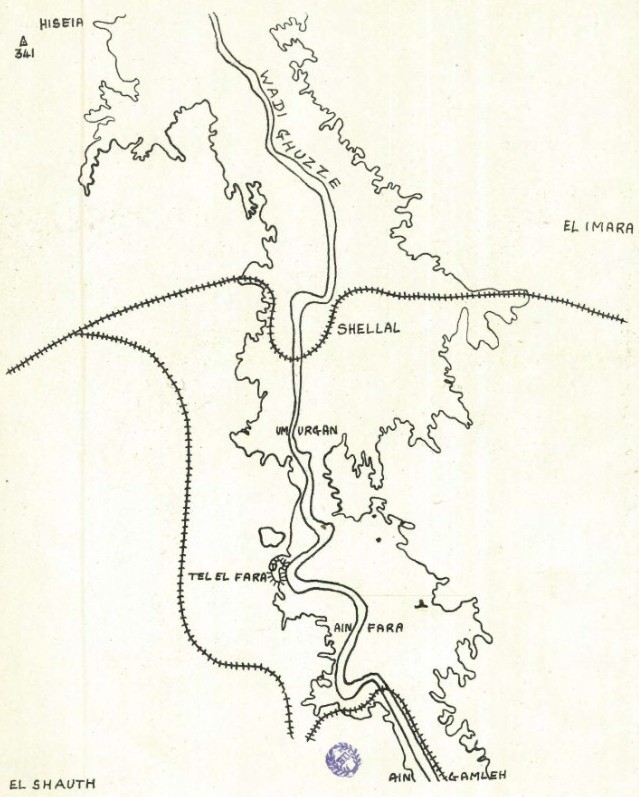
torrent bed is known as the Wady Ghazzeh (Gaza);
its mouth is five miles south of the modern town (Plate I).
CHAPTER IV: THE COPPER AGE
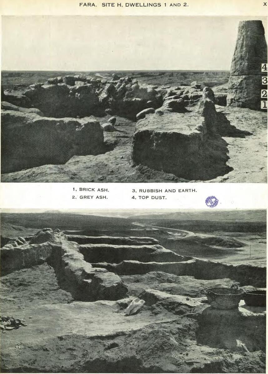
21. Site H The Dwellings : Construction
The peoples of sites D, 0, M, B and A were essentially
desert nomads, moving with their tents from
place to place ; and there was no indication whatsoever
in those sites of mud or brick-made huts.
Indeed, in many cases, the actual floors of the tents
could be traced out with the eye.
The inhabitants of site H however were not tent
dwellers but built rectangular huts (Plate x).
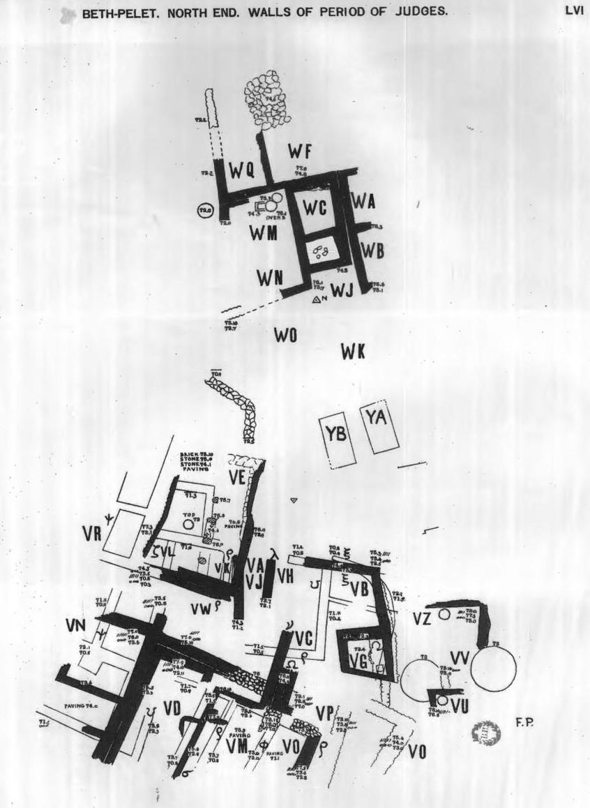
https://ancientneareast.tripod.com/PDF/257876.pdf Pre-History and Archaeology Glossary Abstract: This study reanalyzes the material from the excavations and survey of Eann Macdonald in the Wadi Ghazzeh in 1929-30 which are published in Beth Pelet II. Each site investigated by Macdonald is discussed and analyzed in terms of the stratigraphy recorded in Beth Pelet II and of the material remains gathered through his work ... Four cultural phases are distinguishable: a local ceramic Neolithic phase that is found priarily in Sites B and M; two Beer Sheba-Ghassul Chalcolithic phases in Sites B, E, 0, M, A, and B and an Early Bronze I phase in Site H. These phases are defined on the basis of the technological and typological attributes of the flaked stone and ceramic assemblages. Re-examination of the collections revealed a significant number of Egyptian and Egyptian style flints in Site H as well as the possibility that some of the pottery is a local imitation of Egyptian ceramics. Certain flaked stone artifacts in Chalcolithic contexts may also owe their existence to Egyptian influence ... The analyses are based upon a detailed study of almost 15,000 flaked stone and ceramic artifacts. INTRODUCTION: In 1929-30 Eann Macdonald, a young geologist, was brought out to Beth Pelet by Sir Flinders Petrie to "work" a series of small settlements which had been found during the previous season (Petrie,1932). A total of seven sites were excavated. As far as is discernible the excavated material was shipped back to England to University College with a small selection going to the British Museum, the Ashmolean Museum and the University of Manchester Museum. The final publication Beth Pelet II appeared in 1932. It became evident over the years as more and more work was done in the field that the original publication was inadequate for modern studies. It was therefore decided that the collection should be restudied in conjunction with a more recent research in the same area. This dissertation aims therefore to republish the Wadi Ghazzeh material in the format of a series of site reports using techniques current in prehistoric research and basing the analyses on typologies developed specifically for this proto-historic material.
The Data Base 1) The excavation techniques of Macdonald are unknown, not being recorded in any of the written material investigated. However certain assuptions can be made. The fact that two of the sites Macdonald excavated have been re-excavated (without results differing radically from his) implies that he did not strip the sites (and did not miss much). He was able to publish top plans and sections and discuss finds by provenance which indicates he dug stratigraphically. If it is doubtful that sieving was used, the "baksheesh system" [a tip or small amount of money for an object found] was and sees to have been effective judging by the large quantity of small artifacts and fragments thereof existing in the collection. Therefore it is concluded that he at least found a representative sample of what existed to be found. Tell el-Farah South in The Israel Antiquities Authority Archive 1919-1948 (Mandate Period) 2) The Mandate period file on Tell Fara (S) contains a list dividing the finds between the expedition and the Department of Antiquities. The absence of such a list for the Neolithic sites (nearby) versus the presence of the list for the tell (mound itself) material suggests that all the material was left with the excavators. In addition if any material was left in Israel it is unknown to Israeli archaeologists who specialize in the Chalcolithic and EB I periods. Therefore it is assumed that there was no division of the material and the expedition was free to ship as much of it as desired to England.
The Pottery Typology
THE WADI GHAZZEH
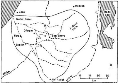
The Wadi Ghazzeh (Nahal Besor) is a seasonal stream which forms the main drainage artery of the Beersheba Basin (map 1) in which all the wadis flow directly or indirectly into the Nahal Besor. The wadi runs west from Har Haluqim in the Judean Hills to the Mediterranean Sea south of Gaza. Two important tributaries are Nahal Beersheba and Nahal Gerar. The area studied is in the semi-arid region lying between the 200 and 300 isohyets. Rain is restricted to the winter months when run-off gullies feed Into the wadi and carve out extensive paths in the country surface, creating badlands. Being in the desert fringe zone, the area is subject to variations in temperature and rainfall from year to year. Average daily temperature, studied over a three year period was found to range from a minimum temperature of 6 degrees C in January to a 20 degree C minimum in August (Bitan-Buttenweiser, 1967). This area of the Negev is one of its most fertile regions. Today over three hundred species of plants can be found (Price Williams, 1975). Much of the region is under cultivation with wheat and barley sown as winter crops. In 1946, before the current development of the Negev, the area was inhabited by Bedouin. It was the most densely inhabited region in the Negev with 12.79 tents and houses per square kilometer as opposed to 2.72 near Beersheba (Muhsam, 1966). Page 13 --- History of Archaeological Work in the Wadi Ghazzeh/Nahal Besor The Wadi Ghazzeh first appeared in published archaeological literature with the excavations of Sir Flinders Petrie at Beth Pelet (BP I). During the course of the excavations evidence of prehistoric settlements appeared.
Petrie's diary for 13th February 1929 records:
"The great development here is in flints. We have many hundreds from the paleolithic from the wady bed and as there is no details or knowledge of the sites -- the flints being washed down the wady -- we buy up all we can. For that reason many sites of settlement have come to light and we give 2 shillings for showing a site. These sites are mostly about First Dynasty time and before and have many pottery fragments. All that wants careful working which must wait till next year. It is a better field for flints than any in Egypt".
The subsequent excavations of seven sites were conducted by Eann
Macdonald in 1929-30.
The Flaked Stone Industry
The second -- Chalcolithic -- is the major industry present in the Wadi Ghazzeh. The tool kit is largely comparable to previously published reports from Beer Sheba-Ghassul culture sites. The quantity of material however allows the presentation of an over-all picture of such an industry. Page 359 --- The third industry present -- E.B. IA -- is almost entirely restricted to Site H with one tool appearing in Site M and sporadic surface occurrences.
The Ceramic Industry
The Chalcolithic phase is defined by ware of local loess with temper adjusted according to the requirements of the vessel under construction. General construction methods are by coils with or without a turned finish; turned; and specialized techniques for specific forms. The shapes and technology fit into the Beer Sheba-Ghassul range. As in the flint industry the ceramic assemblage exhibits the range of types and technology known from the general Beer Sheba-Ghassul culture. The E.B.I phase is almost totally restricted to Site H. It appears sporadically on surface sites. It is characterized by four types of ware, one a continuation of the ware current in the Chalcolithic phase, the others new. There is a strong association between ware type and form. The sherds are undecorated, slipped and/or burnished and may continue the impressed or incised decoration known from the previous phase. A few shapes continue from the Chalcolithic; most fall within the E.B.IA (P.U.A) range known from Azor -- Lachish -- Meser -- Jericho and Bab edh-Dhra. Certain forms are known from phases attributed to P.U.B at Arad and Ai; the painted decoration that appears on those pieces is virtually unknown at Site H. Certain forms, known at Azor and Tell Gat, are attributable to Predynastic Egypt. The Site H examples are however local imitations. The ceramic assemblage offers the same conclusion as the flint assemblage -- lack of a sharp break with the Chalcolithic, a repertoire of E.B.IA forms and decoration and an Egyptian element.
Architecture
Synthesis
Tell el-Far'ah (South) --- Israel Excavation Project
Tell el-Farah (South) --- WikiPedia
|